Showing 762 items
matching c. james
-
 Glen Eira Historical Society
Article - CARNEGIE
This file contains three items about the origin of Carnegie's name:. 1/Three page photocopied article The Town and the Tycoon, undated, by Stephen Collicoat. Brief history on Andrew Carnegie and his family. 2/Twenty one photocopied pages of correspondence between the Mayor and Councillors Edwin James, the secretary Victorian Railways, Fred Jowett, Retallack, J.F.A. Powell, C.A. McCallum dated from 01/08/1908 to 05/08/1969. 3/Photocopied photograph of Rosstown Hotel c.1910 with small article about hotel and licensee, undated and unknown.carnegie, collicoat stephen, rosstown, carnegie andrew, rosstown progress association, koornang, neerim road, maroona road, james edwin, valetta, kokaribb road, petallack j.a., iles mr., fielden mr., amos e.j., murrumbeena, dudley, jowett frederick, town clerk, mimosa road, kooyong, portreath, carnegie railway station, clark t., hotel, rosstown hotel, soames hotel, stage coaches, ross murray, rosstown junction railway, mill, verandahs, horse trough, hitching posts -
Glen Eira Historical Society
Document - Caulfield Sporting Club
This file contains one item. A handwritten report on the formation of the club on 07/03/1934, including company file number 18390, a list of subscribers to memorandum and articles of association, registered address, secretary members and directors year to 31/05/1939.caulfield sporting club, caulfield, subscribers, memorandum, articles of association, jackson william horace, webb arthur john, mccutcheon arthur robert, trusken james, way henry richard, normanby road caulfield, moodie road caulfield, kambrook road caulfield, railway avenue caulfield, stokes henry, hyland albert, williams john, march clifford, harris george, harris monty, v. r. c. trainer, bookmaker, agent, trainer, accountant, clubs, associations, societies, organisations, sports, recreations, competitions, entertainment, sports grounds, leisure, establishments, sports people, public record office, secretary, directors, victorian racing club -
Glen Eira Historical Society
Letter - Oak Avenue, 7, Elsternwick, 'Leongatha/ Corpach'
A typed copy of correspondence from Brighton Historical Society, dated 29/11/1988, detailing the history of residents from construction of 7 Oak Ave, Elsternwick in 1888 through to 1974. The letter also details the names Leongatha and Corpach, giving a brief history on the name Corpach. The second document is handwritten working notes with the same details as the correspondence.oak avenue, wimble h (mrs), hazard f.a., elsternwick, cuthbert kingston, weymuss charles, leongatha, cuthbert e (mrs), cameron william c., corpach, teague maggie, gardener hugh (rev), mcnaughton james, teague j.h. (mrs), sabelberg thomas, crawford edward, cameron margaret, platt james w, platt ellis. r, anderson a. m. (mrs), bullock h. (miss), landells rosalind., postal workers, depression 1890s, anglican church -
Glen Eira Historical Society
Article - Rockbrook Road, 16, St Kilda East
Two items about this property and environs: 1/Photocopy of a typed document, dated 29/02/1988, written by Hilary Bullock and Rosalind Landells of Brighton Historical Society, detailing the history and owners and occupiers of 16 Rockbrook Road, St Kilda East. Accompaying it is a handwritten working note of same with the information coming from 'Sand Swamp and Heath'. 2/A Wikipedia article with Bibliography of James Service, joint owner of Rock Brook, St Kilda East (article last modified 01/10/2009).rockbrook road, 'rock brook', gardiner william, st kilda east, the argus, stevenson william, hotham street, caulfield, taylor percy w., balaclava road, service street, brosnan john c., glen eira road, service james, brosnan l.c. mrs., brosnan m miss, vafeas g., bullock hilary, landells rosalind., industrial workers, merchants, commerce, sports and recreations, journalists, newspapers, roads and streets, houses, premiers, parliamentary representatives, land subdivision, house names -
Glen Eira Historical Society
Document - ‘KENLY’, Gladstone Parade, 34, Elsternwick
This file contains two items about this property: 1/Photocopy of Caulfield conservation study on ‘Kenly’ (1899) completed by Andrew Ward in October 1994. Includes a brief history of owners and tenants from 1888 to 1941 and a description of its architectural features as well as a black and white exterior photograph. 2/Two colour exterior photographs dated 13/10/2011gladstone parade, elsternwick, ‘kenly’, house names, 21-aug-18, mansions, hume c., kooyong park estate, clarence street, jackson thomas b., shoobra road, wells andrew, ford grylls, langwill p., henriques fred, pearson alfred, edmends james, williamson alfred, caulfield, ward andrew, architectural styles, victorian style, verandahs, brick houses, windows -
Glen Eira Historical Society
Document - Carnegie Methodist Church, Neerim Rd, 252- 254, Carnegie
Booklet Carnegie Methodist Church 70th Anniversary Back to Carnegie 1956. Includes history information and Office Bearers of the Church with sketch 130mm x 65mm. Booklet Carnegie Methodist Church, 80th anniversary Back to Carnegie 1966 includes a brief history of the Church. Includes sketch 130mm x 65mm. Booklet Neerim Road (Carnegie) Uniting Church of Australia Formerly Carnegie Methodist Church. Centenary 1886 – 1986 Includes order of Morning Service. Includes exterior photograph 150mm x 80mm.carnegie, carnegie methodist church, schools, parsonages, rosstown state school, churches, sunday schools, methodist church, religious groups, oakleigh circuit, uniting church, methodist circuit, neerim road, williams h. j. rev, wells w. p. rev, jamison mr., wade mr, webb mr, baker mr., wilton mr., pearson mr., barrett mr., evans mr, stables, edgar w. h., secomb w. e. rev, tratham j. rev, rowse j. w. rev., alday t. rev, turner e. rev, leslie j. rev., adamson t. rev., palamountain wid. rev, holtham w. h. rev, wellard w. e. rev, rankin f. j. rev, bridgborn w. c. rev, tregear g. rev., newbegin f. w., harris h. r rev., phillips c. r. rev., wise mr., barnett mr., woods mr., phillp. mr., retallick mr., amos mr., long mr., ellis mr., ralph mr, walker mr., butler mr., snell mr., chisholm mr., bruce mr., sparlio mr., beecham mr., spencer mr., pascoe mr, archer mr., watson mr., arneil r., harwood charles, dunn j. t., gordon r., bracher l. a., johnson a. mrs., welch don, rose frank, hussack francis, marshall noreen, newitam ron, watson lawry, mathias rex rev, churchward a. rev, wallace g. e., smith jack mrs., byron mrs., daniels mrs, williams h. j. mrs, green anne, huffer n. mrs., cawthorn h. a., hunt a. w., kemp w. r. rev, addinsall c. roy, harrison w. r. rev, addisall c. r. mrs, addisall joan, bone bob, johns mrs., gordon e., rodgers keith, govers mrs, watters graham, wesleyan chilf, wesley hall carne, mcconachy r. s. rev, williams les. mrs., festivals and celebrations, mac rae chris, moorhead k. h. rev, shepparson avenue, james street, glenhuntly, toolambool road, edgar w. h., secomb w. e., hillis geoff, barners peter, moyle bruce, barry warrick, kilgour alex, green kevin rev, mcmullin bruce, gaylard heather, byard trevor rev, wells w. p. rev, trathen j, rouse j. w, alday t, turner e, leslie j., adamson t, palamountain w. j., secomb w. e., holtham w. h, hooper r. e., lloyd g., tregear g., shackelly e, rankin f, tonkin e, churchward s, harris g. c, beckett r., hamlett j. b., camilatos p., macrae jenny -
Glen Eira Historical Society
Document - Grosmont
Four pages of undated and unattributed handwritten research notes on the past owners of Grosmont.grosmont, bambra road, bevan mr, hart john, hart family, london, caulfield, caulfield north, bevan james, bevan howard, bevan edward c, thompson walter, hart mrs, hart thomas, bevan james william, bevan james and co, bevan and co, caulfield road board, stables, servants, mansions, carriages and coaches -
Glen Eira Historical Society
Article - Long Street, 10, Elsternwick
Two items about this property: A type written letter dated 03/11/1988 from Rosalind Landells and Hilary Bullock regarding the history of the occupants of 10 Long Street Elsternwick from 1889-1974. Included is a handwritten page of working notes, undated and unattributed listing the occupant history. An advertisement unsourced, dated 26/5/2006 for the forthcoming auction of 10 Long Street. The advertisement describes key architectural and other features of the house and includes a copy of a colour photograph.elsternwick, long street, advertisements, victorian style, land sales, architectural features, auctions, depression 1890s, land subdivision, munro john p, reynolds i a miss, bainbridge f f, ebbs william h, hunt harry, turner m c miss, hobbs cecil h, mcgillivray e mrs, bowles james, place thomas e, murray herbert, mcbride george, homeman george e, answerth l. m mrs, newling arthur, swann herbert c, matheson alfred, hannett r e, sullivan j, bullock hillary, landells rosalind -
Glen Eira Historical Society
Document - Edward Street, 4, Elsternwick
Copy of Brighton Historical Society’s reports dated February 7, 1989 on the house of 4 Edward Street, Elsternwick. Includes a list of residents and a brief history of the house. Also includes a page of unsigned, handwritten research notes.castle george, povey frederick g., grigg thomas, russell george, taylor charles h., taylor annie l., mills m., kidd lesley, mitchell wilfred h., williams frederick, thompson james, devlin oliver o., ladgrove ethel, woolley allan r., stutterd rupert d., phillips j. e., arnett george, fisher g. d., evans g., perry bowker, perry m. g., staff h. c., morton street, terrace houses, world war 1939-1945, bullock hilary, landells rosalind, depression 1890s, depression 1929-1939, elsternwick, edward street -
Glen Eira Historical Society
Plan - Nettalie
... James J C... Montgomery L Parsons W James J C Sibon C Smith Sydney W Plans Maps ...An A4 photocopy of the 'Plan of the Caulfield Road District' dated 1867. This plan shows the location of the properties owned by A Shaw and Blundell on Balaclava and Orrong Roads where Nettalie is situated. The plan includes all the landowners listed where their property was, the street names and other landmarks of 1867 including railways, hotels and reserves.caulfield, caulfield north, elsternwick, st kilda east, parish of prahran, parish of moorabbin, caulfield road district, melbourne and brighton railway, rosstown railway, elsternwick railway station, caulfield railway station, rosstown railway station, murrumbeena railway station, baptist church, paddy’s swamp reserve, cemetery reserve, leman swamp reserve, caulfield racecourse reserve, brighton cemetery, the vine caulfield hotel, the tam o’shanter hotel, melbourne hunt hotel, royal hotel, hotham street, horne street, nepean highway, north road, orrong road, dandenong road, princes highway, kooyong road, alma road, inkerman road, balaclava road, glen eira road, glen huntly road, hawthorn road, cemetery road, bambra road, redan road, kambrook road, neerim road, booran road, racecourse road, grange road, koornang road, murrumbeena road, crosbie road, kangaroo road, poath road, ford w, lempriere, cople j, riddell j c, manifold j, testar t, billing r h, semple, blundell, shaw a, butchart g, stephen j w, stephen g sir, hart j, duncan g, blackie r, stephen f, mccombie t, woollaston h, higgins j, lloyd j c, daish j, mcleod j, hughes d, wilson a, jamieson g, webb g h, renwick s, pennington h, dunn j, kirkpatrick w, ricketson w, toad a, sayce j, watts t, widgery, store, guess j, anketell j, clack j, sissen w, clayton g, dickson d, bevan j, hart t, anderson j, hart mrs, webb h, masters s, waghorn j, hemming c, hiam c, farquhar w, newing t, payne t, cooper r, snipe s, chambers j, forster w, summers r, harriman b, warrick, o’connell, long j, peck r, cochrane c, murray ross w, evans c, kennedy j, maclean n, forster, lyall w, dean j, newton h, looker w, baker c, johnston, crosbie j, kerr, jones, parr, nelson c, montgomery l, parsons w, james j c, sibon c, smith sydney w, plans, maps, land subdivisions, land use, settlements, roads and streets, hotels, churches, police stations, post offices, land surveys, railway stations, railways, schoolhouses, commerce, clergy residences, official buildings, local government, road districts -
Glen Eira Historical Society
Plan - Centre Road, 734, Bentleigh East
A one page typed letter, dated 30/09/1970 addressed to S P Simmonds Estate Agency from William Lasica and Co Solicitors requesting a valuation of the property at 734 Centre Road, Bentleigh East. The file also includes four pages of handwritten, undated and unattributed working notes with property description, calculations and a rough plan (96mm x 94mm) of the ground floor of the building for the valuation. Also included in the file is a two page duplicate copy of a typed letter, dated 08/10/1970 from W V Scott to William and Lasica Co Solicitors containing the valuation of the relevant property and rental details. The file also includes a one page photocopy of a handwritten document dated 15/11/1967. It gives details of a previous mortgage. The file also includes a photocopy, dated 26/09/1970, of the Certificate of Title of Lot 6 of Subdivision No 60044 Parish of Moorabbin. It includes a plan of the property (139mm x 123mm).klauss anna sara, klauss edward, green william james, green margaret estelle, green william thomas, myers thomas lee, lombard joseph patrick, graham george kinnell, tobin thomas norman, mcintosh edward joseph, bentleigh east, east bentleigh, centre road, bentleigh station, omeo court, east boundary road, s p l constructions pty ltd, r k c nominees pty ltd, maryland street caulfield investors, flats, land values, land titles, rents, renting, \ -
Glen Eira Historical Society
Document - Craigellachie
... Thomson Emma Thomson Percy Elliot Sibley C Saint Pearl Roche James ...A documentary and physical investigation into the history and development of Craigellachie, located at 2B Lynedoch Avenue, St Kilda East, by Debra Lewis. Includes an examination of the house’s condition as at 2002, photocopies of photographs and plans of the house illustrating key architectural features and changes to the house. Includes a handwritten letter dated 08/02/2002 from Debra Lewis regarding the donation of the copy of her research paper.craigellachie, lynedoch avenue, st kilda east, lewis debra, gill j, lyall w, young william, smith w sydney, pearson william, orrong road, inkerman street, caulfield, italianate style, architectural styles, sawers john, mcculloch david, crawford minnie, crawford robert, thomson emma, thomson percy, elliot sibley c, saint pearl, roche james, yorston james, griffiths william, francis newton, francis marie, cocks norman, heisler geraldine, freeman julie, freeman richard, cast iron work, stained glass, bibliography, plans, architectural drawings, architectural features -
Glen Eira Historical Society
Letter - Crotonhurst
A letter from Mrs M Ring to the Caulfield Historical Society, dated 14/03/1986, conveying gratitude for the information provided about the house Crotonhurst located at the corner of Hawthorn Road and Glen Eira Road, Caulfield North, and requesting information about the Langdon and Webb families and the property Lirrewa. Enclosed with the letter is a copy of a two page report on the Life of George Frederick Webb. The file also includes a seven page report conducted by Irene Victoria Anderson in 1982 on the history of the Langdon and Webb families and the house Crotonhurst. Two earlier drafts of the same report are included and one of these has further handwritten notes.crotonhurst, rosecraddock, lirrewa, caulfield north, hawthorn road, langdon road, glen eira road, mitchell road, crotonhurst avenue, caulfield city hall, city of caulfield, polo ground, polo parade, neerim road, powderham road, walworth avenue, langdon family, webb family, rosecraddock family, webb george henry frederick, webb george henry webb justice, field matilda, agg sophia sarah, agg sophia sarah annie, webb sophie sarah annie, agg dottie, webb dottie, langdon william farrar, langdon willie, langdon bill, langdon h j mrs, langdon mrs, webb george edward, webb matilda elizabeth, webb isabella elizabeth, webb james hemming, murray peter r, wells john c, langdon marie, langdon clive, murdoch keith, egerton-warburton mr, yorston mr, yorston rita, langdon violet, langdon. philip, gillespie ray, lindsay joan, ring m, paterson mrs, coffey eileen, fitzsimmons eileen, ronald heather, william gluyas, maidment isobel, langdon rr, langdon charles, langdon r b, knox david, langdon dick, hart trevor, mclaughlin j, ballantyne r, webb matilda sarah, somers charles, mckenzie barbara, mcleod lexie, richards barbara, richards lexie, sims betty, anderson irene victoria, short hand writer, lawyers, phthisis, queen’s counsel, judge of the supreme court, court reporter, architectural features, world war 1914-1918, soldiers, point to point steeplechase, master of the hounds, organs, sculptor, statues, stained glass, crests and emblems, elsternwick congregational church, government shorthand writers’ department, eureka treason trials, swamp sand and heath, dickson and yorston, caulfield council, caulfield historical society, harrison ramsay, time without clocks, the hounds are running, melbourne hunt club, st mary’s church, geo. fincham and sons, city hall gallery, mansions -
Glen Eira Historical Society
Document - Eversley, Gladstone Parade, 36, Elsternwick
... William Barbeta Augustine Langwill P Ainslie James Henriques ...A two page photocopy from the Caulfield Conservation Study by Andrew Ward on the house Eversley at 36 Gladstone Parade. The study includes a brief description of the building, building history, a statement of significance and a black and white photograph (100mm x 155mm) of the exterior of the house. The file also includes a poor quality black and white photograph (88mm x 88mm) of the exterior of the house.architectural features, gladstone parade, nulmore, brampton, eversley, kooyong park estate, clarence street, jackson b thomas, architect, shoobra road, dalrymple william, barbeta augustine, langwill p, ainslie james, henriques frederick, hume c, jackson thomas b, ward andrew -
Glen Eira Historical Society
Article - Alnwick, Railway Parade,|11-11A,|Murrumbeena
Letters and research material regarding ‘Alnwick’, 11-11A Railway Parade, Murrumbeena. First two letters were sent by Fay Johnson to Dr. C. Kellaway at the ministry for planning and environment on 16/06/1988 and 10/08/1988. The latter includes research material regarding the ‘ALNWICK’ house including a brief description of the history of Sir James Patterson, photos of the house and a newspaper extract regarding its sale. The other letters were sent to the secretary of Caulfield Historical Society from the Historic Buildings Council inviting them to attend a hearing about ‘Alnwick’s’ classification. Almost identical letters, they were sent on 30/09/1988 and 07/02/1989.kellaway carlotta, johnson fay, kaeppel rose, kaeppel a. j., caulfield shire council, register of historic buildings, railway parade, shire of caulfield rate book, murrumbeena cres, anzac street, murrumbeena road, murrumbeena station, margaret street, caulfield historical society, historic buildings council, classification, historic buildings, historical societies, local history, dandenong road, fitzroy street, spencer david, ford hazel, patterson james sir, patterson james, burrough naomi, walton anna, murrumbeena, carnegie, politician, parliamentary representatives, slaughterman -
Glen Eira Historical Society
Document - Riddell Parade, 48, Elsternwick
Two items about this property: 1/A typed Research report on the history of the property at 48 Riddell Parade, Elsternwick, built in 1916/1917 on a subdivision of John Carre Riddell’s land. Prepared by Hilary Bullock and Rosalind Landells of the Brighton Historical Society, dated 14/08/1992. Includes a list of past owners and residents of the property. Their handwritten working notes, undated, are also included. 2/A plan of the subdivision of Riddell Estate from Sand Swamp and Heath (photocopy).cavers carre, riddell john carre, elsternwick, riddell parade, weedon james, walker alice o mrs, foley christina mrs, foley aileen c dr, 'carmel', house names, mcmillan archibald, mcmillan street, 'sand swamp and heath', carre street, gisborne street, landells rosalind, bullock hilary -
Glen Eira Historical Society
Document - Caulfield Fire Station, No 26, Tree Reserve, Dandenong Road
A three page photocopy of a handwritten memorandum of agreement dated 11/10/1894 between the municipalities of Caulfield and Malvern and the Metropolitan Fire Brigades Board consenting to the erection of a fire station on Tree Reserve. Also a three page photocopy of a handwritten agreement dated 11/10/1894 between owners of properties in the neighbourhood of the junction of Dandenong Road and Waverly Road and the Metropolitan Fire Bridgades Board to allow the Board to erect and use a fire station on Tree Reserve in Dandenong Road. The agreement was signed by the property owners.caulfield east, shire of caulfield, tree reserve, caulfield fire station, rs anderson and son, fire stations, legal documents, lloyd c d, jowett f, delves catherine , catani c, federal building society, st james building society, nathan philip, trustees of the late john nathan, adams j, bates j -
 Eltham District Historical Society Inc
Photograph, Tess Justine (Nillumbik Shire Council), Murray's Bridge over the Diamond Creek, Eltham North, 19 Feb 2022
Murray's Bridge over the Diamond Creek on the Diamond Creek Trail just prior to demolition and replacement with a new steel bridge. Heritage advice obtained by Nillumbik Shire Council, following a suggestion by the Eltham District Historical Society (EDHS), is that the original bridge appears to have been a simplified version of the Country Roads Board’s (CRB) standard timber bridge design of the early-to-mid 1920s. In c1990 Murray’s bridge was renovated with three recycled steel girders as part of a bike/pedestrian path in the reserve. During these alterations many parts of the bridge were removed, and some were replaced. Heritage advice indicates the condition of Murray’s bridge is poor. The remaining original parts are all in poor condition, with severe weathering, splitting and rot, especially to the stringers retained on the bridge. Heritage advice is that Murray’s Bridge does not have sufficient significance in the cultural history of the Nillumbik area to warrant inclusion in the Nillumbik Shire Heritage Overlay and also does not have sufficient significance as a rare survivor to warrant inclusion in the Nillumbik Shire Heritage Overlay. There are no indications in the historical record that this site was individually important to the cultural history of this area. EDHS is comfortable with the heritage advice provided to Council and has worked closely on this project with Council. EDHS has suggested some of the removed timbers be used in the vicinity of the bridge for landscaping and possibly seating, so as to retain these remnants close to the site of the original bridge, which is the last old timber bridge along the lower reaches of the Diamond Creek. Mary (Sweeney) Murray and John Wright Murray selected 80 acres, Lot C Section 16 and Lot 5 Section 17 Parish of Nillumbik, under an occupation license in 1866. John died in 1867 and freehold was granted to his son John in 1873. The farm was known as ‘Laurel Hill’. John Junior was an Eltham Shire councillor and sometime president from 1887 up until 1897. He added Lot A Section 16 to the farm in ca1888. John and his younger brother James arranged to rent/purchase Lot B Section 17, across Diamond Creek to the west, in ca1900. It appears that John and James farmed separately for a few years, with a new homestead built for James ad family on the high point of Lot B Section 17 in ca1910. John sold off Lot 5 Section 17 in 1912. When John died in 1912 James took over the land on both sides of the Diamond Creek. The old homestead on the west side of the Creek disappeared. A farm bridge over Diamond Creek from this period may have been located close to the northern boundary of the farm. John Langlands, owner of the farm known as ‘Ihurst’ on the west side of Diamond Creek to the south of the Murray’s land, died in 1907. In 1909 his land was then subdivided into 100 lots to become the ‘Glen Park Estate’. Other similar subdivisions of nineteenth century farms around Eltham in this period included the ‘Franktonia (or Beard’s) Estate’ to the northeast and ‘Bonsack’s Estate’ between Eltham and Greensborough. Soon after the opening of the railway extension line from Eltham to Hurstbridge in 1912, Glen Park and nearby residents including James Murray agitated for a railway station or siding to be located half-way between Eltham and Hurstbridge, so that the Glen Park residents who used the railway daily did not have to walk into the Eltham or Hurstbridge stations. Some believed Coleman’s Corner (opposite Edendale Farm) was an appropriate spot for the platform. James Murray was among those who thought the railway should be located on his land, closer to half-way between Eltham and Hurstbridge stations. The Railways Commissioners warned that the locals would have to fund these works themselves. The Glen Park Estate residents initially had difficulty accessing Eltham by road, with only an old low-level bridge over Diamond Creek at the south end of their estate. A new timber trestle bridge across the creek, now on Wattletree Road, was opened in 1915. Road access to the north was gained in 1927 when the new Murray’s Road, which crossed the Murray’s land, was built. Residents continued to agitate for a Glen Park station. By 1926 the Railways Commissioners’ preferred site was on the Murray’s land. They arranged an estimate of cost of a full-length platform. The estimate was too much for the locals, who in 1928 argued unsuccessfully for a shorter and hence cheaper platform. By 1929 Murray had agreed to donate the land, but the locals would still have to fund the works. Murray decided, unilaterally it would appear, to commence work on a timber trestle road bridge over Diamond Creek to link the new Murray Road to the proposed station. Late in 1929 he stopped work on the bridge, for reasons unknown, but started work again and completed the bridge in 1931. There is no further newspaper evidence of the campaign for the Glen Park station until 1939, when Murray and another local, Mr Maxwell, met the Railways Commissioner. The Glen Park locale now included 45 homes on the west side of the creek and 20 on the Eltham side. Most of the residents used the train every day. The Commissioner remained adamant that only a full-length platform could be built for safety reasons. It appears the campaign dissolved at this point. The increasing move to cars may have had an impact. There is no evidence of Murray’s bridge ever being connected to Murray’s Road, or of it having wide use for any purpose by locals. James Murray died in 1947 and the farm was taken over by his son James (Jim). Jim started to sell off parts of the farm in the 1980s, retaining a few acres around the ca1910 homestead and building a new house there. Recreation reserves were established along the creek. In ca1990 Murray’s bridge was renovated with steel girders as part of a bike/pedestrian path in the reserve. The old farmhouse was demolished in ca2014. * * * A theory posted on local community Facebook groups was that the bridge was built in the 1860s and was built to be more robust than was necessary for the movement of cows from one side of the creek to the other. It was suggested the robustness was necessary to support the weight of gold ore being transferred from a mine on Murray’s land to a railway siding near Murrays Bridge (presumably for transfer and processing at Diamond Creek). Perhaps this may have been one of the motivators for Murray, who really knows? Knowing when mining operations ceased on his land and how that fits the overall timeline would be useful but at the time the bridge was built, local gold production was minimal at best. The known facts are: • The railway line came to Eltham in 1902. • The extension of the railway from Eltham to Hurstbridge was constructed in 1912 so no railway line even existed through Murray's property until 1912 and the Victorian Railways maps at the time show no such siding on Murray’s property. • In 1923 a new company was formed in anticipation of the old Diamond Creek Gold Mine being re-opened. The mine had been previously closed and flooded. It was noted in the press at the time that the mine was within a mile of the railway. Nothing really came of this. • Construction of Murrays Bridge was commenced by James Murray in early 1929 in anticipation of a proposed flag station being nominated on his land, but work ceased shortly afterwards. The proposed flag station was commonly referred to as Glen Park as the residents of the Glen Park Estate wanted Option 1, located near them with the platform adjacent to Colemans corner. This was probably never going to fly as it was virtually in eyesight of Eltham station. Allandale Road was the third option, but the Commissioners' preferred option was No. 2 - on Murray's property. • The Railway Commissioners were not going to finance any such station and the works had to be funded by private landowners and residents, hence Murray investing in this himself. • Murray recommenced work two years later and finished his bridge in 1931 but unfortunately for him, the proposed flag station never eventuated. The bluestone siding you reference may well have been built by Murray as part of the proposed station platform. • Up until then, apart from the Main Road bridge, which was washed away in 1924, virtually all local crossings over the Diamond Creek were low lying bridges – Kaylocks Bridge at Brougham Street, Diamond Street bridge, Glen Park Road bridge. It is expected that Murray also had a low-lying bridge to connect his land either side of the creek. These were all washed away or severely damaged multiple times in the 1920s. Lessons were learnt, and Murrays Bridge appears to have been built in accordance with Country Road Board standards of the time. Flood damage was ongoing, and even more recently constructed raised bridges kept getting washed away, e.g., the new Wattle Tree Road bridge in 1958 just months after completion. Murray’s bridge was reinforced with steel some 30 years ago presumably to provide additional floodwater resistance, given the history of bridges disappearing in floodwaters. • In March 1932 it was reported in the Advertiser that there were still some prospectors operating around Eltham North who apart from further scarring the face of the earth over the previous two years had gained significant experience but little gold - hardly a driving factor for constructing a dedicated railway siding and bridge to transfer gold ore. It is far more probable that James Murray was hoping to have the railway station located on his property and invested his money by building the bridge to lead to it as well as a station platform. Had the station eventuated, it may well have driven up the value of his land for subdivision and new housing estates like the Glen Park Estate. That did not eventuate. Whilst the bridge was indeed old (90 years), the core structure being completed in 1931, it had been modified substantially from original and hence had no significant historic value – i.e., it was not a representative example of its type, construction, and age. Given that the bridge was not worthy of saving, the Eltham District Historical Society with Council’s support, and the Eltham Woodworkers group endeavoured to see what suitable sized timbers were salvageable to fabricate a commemorative seat. Unfortunately, the experts at the Woodworkers group were unable to salvage any suitable length/width timbers to fabricate the seat due to the presence of rot. Last remaining wooden trestle bridge on the Diamond Creek Trail just prior to demolition and replacementBorn digital image (27)diamond creek (creek), diamond creek trail, murrays bridge, ‘laurel hill’, john wright murray, mary (sweeney) murra, john murray jnr, james murray, john langlands, ‘ihurst’, ‘glen park estate’, beard's estate, franktonia, bonsack's estate, glen park estate, glen park railway station -
 Eltham District Historical Society Inc
Photograph, Tess Justine (Nillumbik Shire Council), Construction work on replacement of Murray's Bridge over the Diamond Creek, Eltham North, 31 Mar 2022
Construction work on replacement of Murray's Bridge over the Diamond Creek on the Diamond Creek Trail Mary (Sweeney) Murray and John Wright Murray selected 80 acres, Lot C Section 16 and Lot 5 Section 17 Parish of Nillumbik, under an occupation license in 1866. John died in 1867 and freehold was granted to his son John in 1873. The farm was known as ‘Laurel Hill’. John Junior was an Eltham Shire councillor and sometime president from 1887 up until 1897. He added Lot A Section 16 to the farm in ca1888. John and his younger brother James arranged to rent/purchase Lot B Section 17, across Diamond Creek to the west, in ca1900. It appears that John and James farmed separately for a few years, with a new homestead built for James ad family on the high point of Lot B Section 17 in ca1910. John sold off Lot 5 Section 17 in 1912. When John died in 1912 James took over the land on both sides of the Diamond Creek. The old homestead on the west side of the Creek disappeared. A farm bridge over Diamond Creek from this period may have been located close to the northern boundary of the farm. John Langlands, owner of the farm known as ‘Ihurst’ on the west side of Diamond Creek to the south of the Murray’s land, died in 1907. In 1909 his land was then subdivided into 100 lots to become the ‘Glen Park Estate’. Other similar subdivisions of nineteenth century farms around Eltham in this period included the ‘Franktonia (or Beard’s) Estate’ to the northeast and ‘Bonsack’s Estate’ between Eltham and Greensborough. Soon after the opening of the railway extension line from Eltham to Hurstbridge in 1912, Glen Park and nearby residents including James Murray agitated for a railway station or siding to be located half-way between Eltham and Hurstbridge, so that the Glen Park residents who used the railway daily did not have to walk into the Eltham or Hurstbridge stations. Some believed Coleman’s Corner (opposite Edendale Farm) was an appropriate spot for the platform. James Murray was among those who thought the railway should be located on his land, closer to half-way between Eltham and Hurstbridge stations. The Railways Commissioners warned that the locals would have to fund these works themselves. The Glen Park Estate residents initially had difficulty accessing Eltham by road, with only an old low-level bridge over Diamond Creek at the south end of their estate. A new timber trestle bridge across the creek, now on Wattletree Road, was opened in 1915. Road access to the north was gained in 1927 when the new Murray’s Road, which crossed the Murray’s land, was built. Residents continued to agitate for a Glen Park station. By 1926 the Railways Commissioners’ preferred site was on the Murray’s land. They arranged an estimate of cost of a full-length platform. The estimate was too much for the locals, who in 1928 argued unsuccessfully for a shorter and hence cheaper platform. By 1929 Murray had agreed to donate the land, but the locals would still have to fund the works. Murray decided, unilaterally it would appear, to commence work on a timber trestle road bridge over Diamond Creek to link the new Murray Road to the proposed station. Late in 1929 he stopped work on the bridge, for reasons unknown, but started work again and completed the bridge in 1931. There is no further newspaper evidence of the campaign for the Glen Park station until 1939, when Murray and another local, Mr Maxwell, met the Railways Commissioner. The Glen Park locale now included 45 homes on the west side of the creek and 20 on the Eltham side. Most of the residents used the train every day. The Commissioner remained adamant that only a full-length platform could be built for safety reasons. It appears the campaign dissolved at this point. The increasing move to cars may have had an impact. There is no evidence of Murray’s bridge ever being connected to Murray’s Road, or of it having wide use for any purpose by locals. James Murray died in 1947 and the farm was taken over by his son James (Jim). Jim started to sell off parts of the farm in the 1980s, retaining a few acres around the ca1910 homestead and building a new house there. Recreation reserves were established along the creek. In ca1990 Murray’s bridge was renovated with steel girders as part of a bike/pedestrian path in the reserve. The old farmhouse was demolished in ca2014. Born digital image (5)diamond creek (creek), diamond creek trail, murrays bridge, ‘laurel hill’, john wright murray, mary (sweeney) murra, john murray jnr, james murray, john langlands, ‘ihurst’, ‘glen park estate’, beard's estate, franktonia, bonsack's estate, glen park estate, glen park railway station -
 Eltham District Historical Society Inc
Photograph, Willis Vale on the north bank of the Plenty River, Church Street, Greensborough, c.1950
Photo sourced from Heidelberg Historical Society reproduced on p63 of The Diamond Valley Story by Dianne H. Edwards, Shire of Diamond Valley 1979. "Willis Vale, Greensborough, situated on the north bank of the Plenty River at the end of Church Street. The home wasa built about 1840 by Jame Willis Mayger from bricks hand-made nearby. It was later passed to the Partington family and when this photo was taken the building was deserted. Vandals and finally a bushfire destroyed Willis Vale in the 1950s." Greensborough Historical Society has same image with more accurate information on the date/cause of fire damage https://victoriancollections.net.au/items/585b6c96d0ce2c1268f1c96b "House built by Edward Maygar, Robert Whatmough lived there mid 19th century and later sold to Partington family. It was located on the Plenty River at Partington's Flat Greensborough. The derelict Willis Vale house was destroyed in 1964 when a fire originating from North Plenty Gorge - Kurrak Road - was lit by two teenage boys and made its way several kilometres down to Partington's Flat Greensborough."Black and white copy of photo printed on glossy photographic paper 30.5 x 40.5 cm (12 x 16 inch); image size approx. 18.5 x 28 cmchurch street, diamond valley story, greensborough, james willis mayger, partington family, willis vale -
 Eltham District Historical Society Inc
Photograph, Willis Vale on the north bank of the Plenty River, Church Street, Greensborough, c.1950
Photo probably sourced from Heidelberg Historical Society, Similar photo reproduced on p63 of The Diamond Valley Story by Dianne H. Edwards, Shire of Diamond Valley 1979. Black and white copy of photo printed on glossy photographic paper 30.5 x 40.5 cm (12 x 16 inch); image size approx. 18.5 x 28 cmchurch street, diamond valley story, greensborough, james willis mayger, partington family, willis vale -
 Eltham District Historical Society Inc
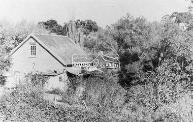
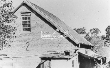
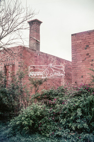
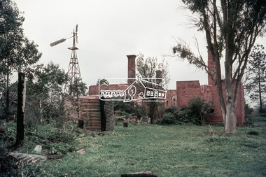
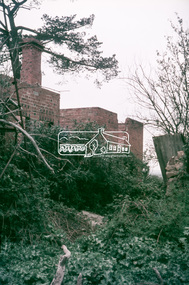
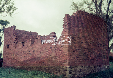
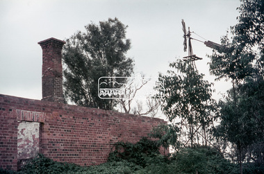
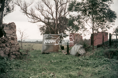
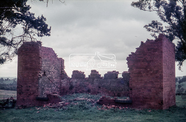
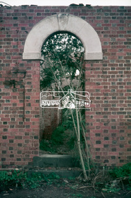
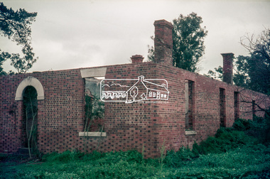
Slide, "Kangaroo Hall" (c.1843-1969), Donaldsons Road, Kangaroo Ground, which was destroyed during the January 8, 1969 bushfire; c.1975, 1975c
Built by James and Isabella Donaldson at the centre of their 1 square mile property southwest of the present day Presbyterian Church. The Donaldsons first arrived in Port Phillip on 17 December 1841. Their first house was a bark hut which was replaced by this substantial brick home around the mid 1840s. James Donladson died 1856. Kangaroo Ground Presbyterian Church http://kgpc.pcvic.org.au/history-2.html Pictures of the farm and homestead (rented by Mr E. Hobson) were published in The Weekly Times, 18 March 1911, p27 1911 'MR. E. HOBSON'S FARM AT KANGAROO GROUND.', Weekly Times (Melbourne, Vic. : 1869 - 1954), 18 March, p. 27. , viewed 29 Feb 2020, http://nla.gov.au/nla.news-article222243528 A letter from Mr Hobson published in the following edition clarified that he only rented the property and that the owner was Mr John Donaldson of Sandringham 1911 'KANGAROO GROUND.', Weekly Times (Melbourne, Vic. : 1869 - 1954), 25 March, p. 47. , viewed 29 Feb 2020, http://nla.gov.au/nla.news-article22224117935 mm colour positive transparency Mount - Agfacolor Service (Blue)bushfire, donaldson home, donaldsons road, isabella donaldson, james donaldson, kangaroo ground, kangaroo hall, victorian bushfires - 1969 -
 Eltham District Historical Society Inc
Slide, "Kangaroo Hall" (c.1843-1969), Donaldsons Road, Kangaroo Ground, which was destroyed during the January 8, 1969 bushfire; c.1975, 1975c
Built by James and Isabella Donaldson at the centre of their 1 square mile property southwest of the present day Presbyterian Church. The Donaldsons first arrived in Port Phillip on 17 December 1841. Their first house was a bark hut which was replaced by this substantial brick home around the mid 1840s. James Donladson died 1856. Kangaroo Ground Presbyterian Church http://kgpc.pcvic.org.au/history-2.html Pictures of the farm and homestead (rented by Mr E. Hobson) were published in The Weekly Times, 18 March 1911, p27 1911 'MR. E. HOBSON'S FARM AT KANGAROO GROUND.', Weekly Times (Melbourne, Vic. : 1869 - 1954), 18 March, p. 27. , viewed 29 Feb 2020, http://nla.gov.au/nla.news-article222243528 A letter from Mr Hobson published in the following edition clarified that he only rented the property and that the owner was Mr John Donaldson of Sandringham 1911 'KANGAROO GROUND.', Weekly Times (Melbourne, Vic. : 1869 - 1954), 25 March, p. 47. , viewed 29 Feb 2020, http://nla.gov.au/nla.news-article22224117935 mm colour positive transparency Mount - Agfacolor Service (Blue)bushfire, donaldson home, donaldsons road, isabella donaldson, james donaldson, kangaroo ground, kangaroo hall, victorian bushfires - 1969