Showing 273 items
matching campus map
-
 Federation University Historical Collection
Map, Town of Buninyong, 1927, 09/1927
The date of this map is September 1927 revised from the original 1910 map. Buninyong was created a district on 09 July 1858, proclaimed a Shire on 16 February 1864, and the Buninyong Borough united on 01 October 1915.Township plan of the Town of Buninyong showing government roads and crown allotments. Earlier detail pencilled on (commercial buildings, etc) appears to be from an 1850 survey. Scale: 4 chains to 1 inch (1:3168)buninyong, map, buninyong botanical gardens, tannery dam, buninyong reservoir, chapel school, rev. hastie -
 Federation University Historical Collection
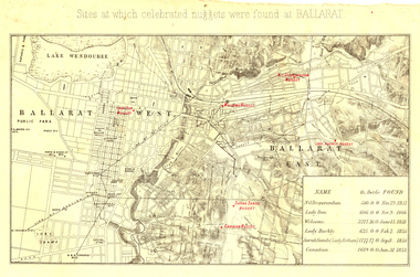
Map, Sites at which celebrated nuggets were found at Ballarat
Foolscap map showing the streets of Ballarat with sites of large gold nuggets found in the 1850s indicated in red. The gold nuggets are the Nil Desperandum Nugget, the Lady Don Nugget, the Welcome Nugget, the Lady Barkly Nugget, the Sarah Sands Nugget (or Lady Hotham Nugget), and the Canadian Nugget, and their weight and date of discovery are gballarat, gold nuggets, nil desperandum nugget, lady don nugget, welcome nugget, lady barkly nugget, sarah sands nugget, lady hotham nugget, canadian nugget, cgt -
Federation University Historical Collection
Map - Framed image, Public Record Office Victoria, Eureka Treason Trial Map (printed copy), 1855
The persecution produced the original of this map as an exhibit for the Treason Trials of thirteen of the Eureka Stockade in Melbourne in 1855. Witnesses at the time accepted that the map showed the location of the stockade at Ballarat and the route taken by the military and police when the stockade was attacked on 03 December 1854. The original of this work is held by the Public Record Office Victoria.Printed copy of the plan used at the Eureka Treason Trials in 1855.eureka stockade, treason trial map, ballarat, lydiard street north, camp street, paroompi, yarrowee creek -
 Federation University Historical Collection
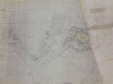
Program, Booklet, Newspaper Cuttings, Map, Mount Lyell Contour Map
Copy of a contour map of Mount Lyell, Tasmania, showing the mining areas of West Lyell, Glen Lyell. Gormanston, Cape Horn and Comstock.mount lyell, tasmania, contour map -
 Federation University Historical Collection
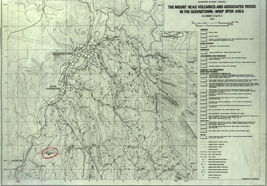
Map, The Mount Read Volcanics and Associated Rocks in the Queenstown - Whip Spur Area, 1978, 1978
Contour map of the Queenstown area in Tasmania, Australia.department of mines tasmania, volcanics, mount read, queesntown, whip spur, mining, king river, gormanston, mt owen, lynchford -
 Federation University Historical Collection
Booklet, Luplau, Hewood & Riderm Printers, The School of Mines Ballaarat Annual Report 1883, 1883
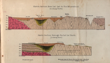
The School of Mines Ballaarat. Annual Report 1883. Statement of Receipts and expenditure, general balance sheet, and list of subscriptions donations 1882. Sketch of School of Mines. Sketch Section from Lal Lal to the Moorabool (looking north) Geological map of Lal Lal. In the County of Grant. Annual Report, Balance Sheet, Certificates granted by the Council, Examination Papers - Elementary Science Classes (Appendix), Extracts from Visitors' Book, Fees, Form of Bequest, Honorary Correspondents. Life Governors, Museum - open to visitors, Notes on the Geology of Lal Lal (with Geological Plan & Sections), Obituary, Office Bearers, Paper of Particulars, Rules of the Ballaarat Field Club and Science Society (Appendix), Report of the Curator of the Museum and Library, Report of the Superintendent of Laboratories, Report of the Lecturer in Mathematics, Report of the Lecturer in Mechanical Engineering, Report of the Lecturer in Telegraphy, Report of the Lecturer in Materia Medica, Statement of Receipts and Expenditure for the year 1882, Subjects and Lectures, Subjects and Examiners, Subscriptions and Donations, from 1st January to 31st December 1882.Ballaarat School of Mines annual Report. Hard cover red book of 101 pages. Includes plans on Lal Lal and surrounds. ballarat school of mines, annual report, balance sheet, certificates granted by the council, examination papers, extracts from the visitors' book, fees, form of bequest, honorary correspondents, life governors, museum, notes on the geology of lal lal, obituary: charles william thomas. one of the examiners in mining and surveying, office bearers, paper of particulars, rules of the ballaarat field club and science society, report of the curator of the museum and library, report of the superintendent of laboratories, report of the lecturer in mathematics, report of the lecturer in mechanical engineering, report of the lecturer in telegraphy, report of the lecturer in materia medica, statement of receipts and expenditure for the year 1882, subjects and lectures, subjects and examiners, subcriptions and donations, from 1st january to 31st december 1882, alf. mica smith, professor of chemistry, alf. mica smith, metallurgy, f. m. krause - professor of geology, mineralogy, scientific mining, t. h. thompson, practical mining, w. h. shaw mechanical engineering, h. reid, mechanical enginnering, phoenix foundry company (limited), a. a. buley, mathematics, f. m. krause, land, mining and engineering surveying, w. d. campbell, telegraphy, james oddie, vice-president, alf. mica smith, natural philosophy (elementary mechanics and hydrostatics, magnetism and electricty, sound, light and heat), j. f. usher, materia medica, pharmacy and physiology, examiner, professor h. m. andrew, m. a., examiner, h. d. de la poer wall, m. a, c. e., examiner, thomas mann, b. a., examiner, p. c. fitzpatrick, c. s., examiner, h. rosale, j.p., f.g.s, m.e. and m, examiner, john lewis, examiner, w. c. kernot, m.a., c.e., examiner, professor mccoy, examiner, j. cosmo newbery, c.m.g., b. sc., examiner, baron von mueller, k.c.m.g., m. et ph. d., f. r.s., examiner, sam. w. macgowan, examiner, w. p. bechervaise, examiner, r. l. j. ellery, f.r.s. govt. astronomer, examiner, f. m. krause, c.e., examiner, j. m. bickett, examiner, n. kent, examiner, a. martin, examiner, r. s. mitchell, examiner, w. h. keast, examiner, p. matthews, examiner, d. milliken, examiner, j. t. richards, examiner, jonathan robinson, examiner, t. h. thompson, examiner, h. brookes allen, m.d., examiner, joseph bosisto, examiner, c. r. blackett, m.l.a., examiner, wm. johnson, analyst to the government of victoria, ferdinand krause, ballarat field naturalists club, ferdinand von mueller, thomas mann, a.a. buley, ferrdinand krause, alfred mica smith, james oddie, william johnson, jonathan robinson, james bickett, r.l.j. ellery, cosmo newbery, ballarat field naturalists -
Federation University Historical Collection
Book, Maldon Historic Reserve Management Plan, 1989, 1989
This book was prepared by the Royal Botanic Gardens, Mebourne Soft covered report of 83 pages, including 10 folded leaves of plates , and 11 maps (some coloured). maldon, geology, flora, vermin, parkin's reef, derby hill, beehive reef, long gully, union hill, mount tarrengower, eaglehawk gully, porcupine flat, neggetty range, peg leg gully, sandy creek, smiths creek, landscape -
Federation University Historical Collection
Book, Wendy Jacobs et al, Maldon Conservation Study, 1977, 1977
Brown soft covered book of 94 pages. It includes pull out maps and plans. conservation, maldon, planning, john templeton, porcupine flat, tarrengower, mining, architecture, town and country planning board, wendy jacobs, miles lewis, gary vines -
Federation University Historical Collection
DVD, British Film Institute, South - Sir Ernest Shackleton's Heroic Expedition to the Antartic, 2002
A story of British pluck, self-sacrifice and indomitable courage brought to life by Australian Cameraman Frank Hurley Audio Commentary by Film Historian Luke McKernan Shackleton's Funeral Recently Discovered Footage - The Ross Sea Party with commentary by Kelly Tyler, Additional footage from South Map of the Expedition with narrative by Kelly Tyler Umbrella Propaganda DVD in hard covered DVD Box. Photo of Sir Ernest Shackleton and a ship on the front cover.sir ernest shackleton, antarctic, expedition, map, south pole, the endurance, shakleton's funeral -
Federation University Historical Collection
Book, Allen & Unwin Australia Pty Ltd et al, The Last Antarctic Heros by Lennard Bickel, 1989
The Last Antarctic Heros. This journey is without parallel in the annals of polar expedition....a task almost beyond human endurance. Lennard Bickel has made a career of writing little-known epics of human triumphs over adversity, triumphs that have brought benefit to mankind.Green book with titles in white font, 230 pages.sir ernest shackleton, antarctic, maps, roald amundsen, douglas mawson, captain scott, ernerst shackleton, frank hurley, captain aeneas mackintosh, ernest mills joyce, ernie wild, dick richards, reverend a. p. spencer-smith, irvine gaze, keith jack, aurora, endurance, weddell seals, scott's 1910 hut, cape evans, cape evans, r.w. richards -
Federation University Historical Collection
Book, City of Ballaarat Planning Scheme Review: Planning Policies Identification Summary Report, 1980, 02/1980
Brown soft covered book outlining the City of Ballarat Planning Scheme Review . Includes black and white images and a map.city of ballaarat, city of ballarat planning, planning scheme review, map -
 Federation University Historical Collection
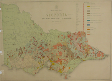
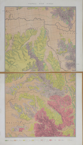
Map, Department of Mines - Victoria, Geological Map of Victoria, 1936, 1936
Printed colour geological map of Victoria.victoria, geology, map, geological map -
 Federation University Historical Collection
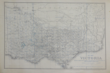
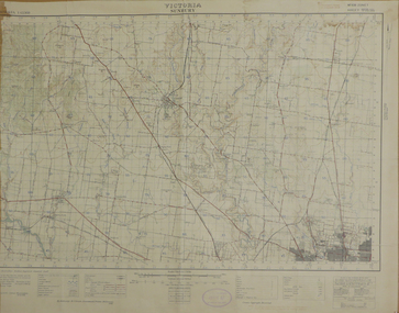
Map, Key Map of Victoria, 1917, 13/12/1917
Printed colour mapvictoria -
 Federation University Historical Collection
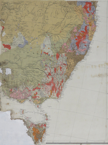
Map, South East Australia, not dated
Printed colour maptasmania, new south wales, victoria -
 Federation University Historical Collection
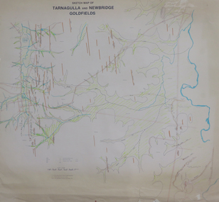
Plan, Sketch Map of Tarnagulla and Newbridge Goldfields, 1979, 1979
Pmap on paper with hand colouringtarnagulla, newbridge, map -
 Federation University Historical Collection
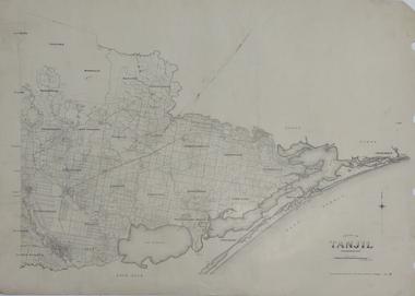
Map, County of Tanjil, 23/11/1906
Printed map on papertanjil -
 Federation University Historical Collection
Map, Sunbury, 1938
Printed colour map on papersunbury -
 Federation University Historical Collection
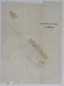
Map, Gold Mining Lease Blocks at St Arnaud, not dated
Printed map on paper with shadingst arnaud, lexell creek, st arnaud creek, wilsons hill, lord nelson -
 Federation University Historical Collection
Map, Stawell, Victoria, 1878
Printed colour map on paper, edged in masking tape stawell, e.r. morris, william collard smith -
 Federation University Historical Collection
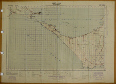
Map, Sorrento, 1931, 03/1931
Printed colour map on paper showing Sorrento and surroundssorrento, point nepean, point lonsdale, queenscliff, port phillip bay -
 Federation University Historical Collection
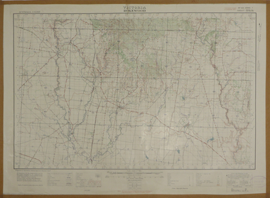
Map, Rokewood, 1937, 02/1937
printed colour map on paperrokewood, illabrook, woady yaloak river -
 Federation University Historical Collection
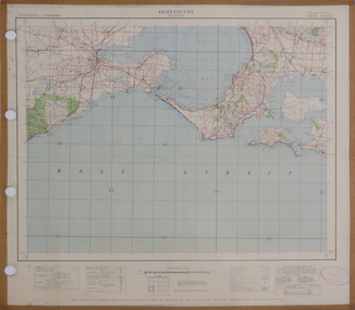
Map, Queenscliff, 1942, 1942
Two copies of printed colour map on paper showing Queenscliff and surrounds"This map in an official document, if found, it must be handed in to the nearest military headquarters or police station."queenscliff, portsea, point nepean, point lonsdale, barwon heads, geelong, corio bay, port phillip bay -
 Federation University Historical Collection
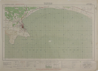
Map, Portland, 1942, 1942
Printed colour map on paper"This map is an official document. If found, it must be handed in to the nearest military headquarters or police. porland, cape nelson, lawrence rock, point danger, whaler's point -
 Federation University Historical Collection
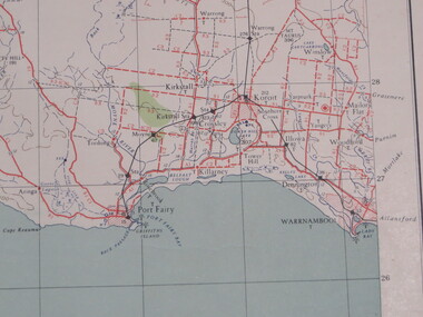
Map, Portland, 1941, 1941
Printed colour map on paperportland, port fairy, warrnambool, kirkstall, crossley, koroit, tower hill, woolsthorp -
 Federation University Historical Collection
Map, Port Fairy, 1942
Printed colour mapport fairy, tower hill, killarney, armstrong bay, crossley, southern cross, kirkstall -
 Federation University Historical Collection
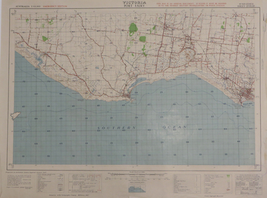
Map, Port Campbell, 1942, 1942
Printed colour map on paperport campbell -
 Federation University Historical Collection
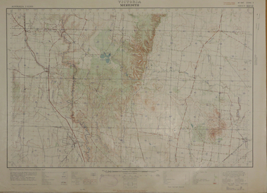
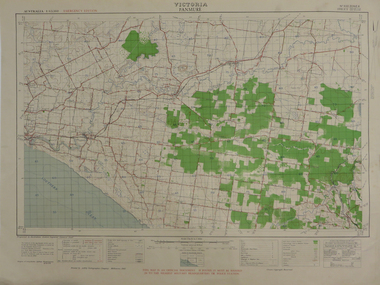
Map, Meredith, 1936, 08/1936
Printed colour mapmeredith, lethbridge, steiglitz, little river -
 Federation University Historical Collection
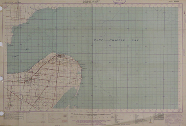
Map, Portarlington, 1929, 09/1929
Printed colour mapport arlington, corio bay, port phillip bay, clifton springs, swan bay, swan island, duck island, point wilson -
 Federation University Historical Collection
Map, Panmure, 1942, 1942
Printed colour map on paperpanmure, garvoc, curdie, allansford, bushfield, hopkins river -
 Federation University Historical Collection
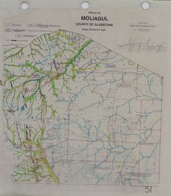
Map, Moliagul
printed map with hand colouringmoliagul, welcome stranger nugget