Showing 535 items
matching concrete constructions
-
 Greensborough Historical Society
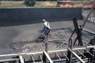
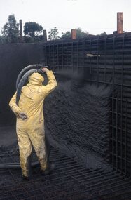
Photograph - Digital Image, Watsonia High School Pool, Construction 1976. Spraying concrete 2, 12/12/1976
... Watsonia High School Pool, Construction 1976. Spraying... spraying concrete onto the pool floor. While the school has gone ...The swimming pool at Watsonia High School was commenced in 1976 and opened in 1977. This photo shows spraying concrete onto the pool floor.While the school has gone, the pool remains in 2019, operating as Yarra Swim School, Liat Way GreensboroughDigital copy of colour photograph, scanned from slide. Slide set at Item 6513.watsonia high school, swimming pools greensborough -
 Greensborough Historical Society
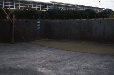
Photograph - Digital Image, Watsonia High School Pool, Construction 1976. Concrete complete, 12/12/1976
... Watsonia High School Pool, Construction 1976. Concrete..., Construction 1976. Concrete complete Photograph - Digital Image Herb ...The swimming pool at Watsonia High School was commenced in 1976 and opened in 1977. This photo shows the completed concrete of the pool.While the school has gone, the pool remains in 2019, operating as Yarra Swim School, Liat Way GreensboroughDigital copy of colour photograph, scanned from slide. Slide set at Item 6513.watsonia high school, swimming pools greensborough, yarra swim school -
 Greensborough Historical Society
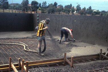
Photograph - Digital Image, Watsonia High School Pool, Construction 1976. Spraying concrete 3, 12/12/1976
... Watsonia High School Pool, Construction 1976. Spraying..., Construction 1976. Spraying concrete 3. Photograph - Digital Image Herb ...The swimming pool at Watsonia High School was commenced in 1976 and opened in 1977. This photo shows spraying concrete onto the pool floor.While the school has gone, the pool remains in 2019, operating as Yarra Swim School, Liat Way GreensboroughDigital copy of colour photograph, scanned from slide. Slide set at Item 6513.watsonia high school, swimming pools greensborough, yarra swim school -
 Greensborough Historical Society
Photograph - Digital Image, Watsonia High School Pool, Construction 1976. The deep end sprayed, 12/12/1976
The swimming pool at Watsonia High School was commenced in 1976 and opened in 1977. This photo shows the completed concrete on the deep end of the pool.While the school has gone, the pool remains in 2019, operating as Yarra Swim School, Liat Way GreensboroughDigital copy of colour photograph, scanned from slide. Slide set at Item 6513.watsonia high school, swimming pools greensborough, yarra swim school -
 Greensborough Historical Society
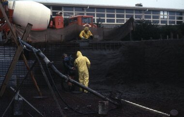
Photograph - Digital Image, Watsonia High School Pool, Construction 1976. Concrete truck and workers spraying concrete, 12/12/1976
... Watsonia High School Pool, Construction 1976. Concrete.... Watsonia High School Pool, Construction 1976. Concrete truck ...The swimming pool at Watsonia High School was commenced in 1976 and opened in 1977. This photo shows a concrete truck and workers spraying concrete onto the pool.While the school has gone, the pool remains in 2019, operating as Yarra Swim School, Liat Way GreensboroughDigital copy of colour photograph, scanned from slide. Slide set at Item 6513.watsonia high school, swimming pools greensborough, yarra swim school -
 Greensborough Historical Society
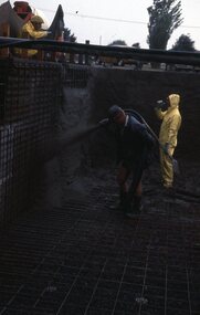
Photograph - Digital Image, Watsonia High School Pool, Construction 1976. Spraying concrete onto the walls of the pool 1, 12/12/1976
... Watsonia High School Pool, Construction 1976. Spraying..., Construction 1976. Spraying concrete onto the walls of the pool 1 ...The swimming pool at Watsonia High School was commenced in 1976 and opened in 1977. This photo shows workers spraying concrete onto the pool.While the school has gone, the pool remains in 2019, operating as Yarra Swim School, Liat Way GreensboroughDigital copy of colour photograph, scanned from slide. Slide set at Item 6513.watsonia high school, swimming pools greensborough, yarra swim school -
 Greensborough Historical Society
Photograph - Digital Image, Watsonia High School Pool, Construction 1976. Spraying concrete onto the walls of the pool 2, 12/12/1976
... Watsonia High School Pool, Construction 1976. Spraying..., Construction 1976. Spraying concrete onto the walls of the pool 2 ...The swimming pool at Watsonia High School was commenced in 1976 and opened in 1977. This photo shows workers spraying concrete onto the pool.While the school has gone, the pool remains in 2019, operating as Yarra Swim School, Liat Way GreensboroughDigital copy of colour photograph, scanned from slide. Slide set at Item 6513.watsonia high school, swimming pools greensborough, yarra swim school -
 Greensborough Historical Society
Photograph - Digital Image, Watsonia High School Pool, Construction 1976. Spraying concrete onto the walls of the pool 3, 12/12/1976
... Watsonia High School Pool, Construction 1976. Spraying.... Watsonia High School Pool, Construction 1976. Spraying concrete ...The swimming pool at Watsonia High School was commenced in 1976 and opened in 1977. This photo shows workers spraying concrete onto the pool (distance shot).While the school has gone, the pool remains in 2019, operating as Yarra Swim School, Liat Way GreensboroughDigital copy of colour photograph, scanned from slide. Slide set at Item 6513.watsonia high school, swimming pools greensborough, yarra swim school -
 Greensborough Historical Society
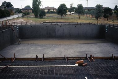
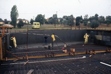
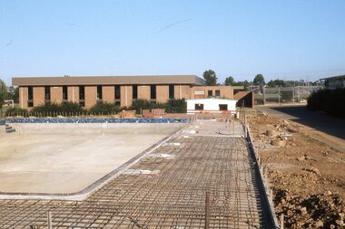
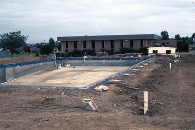
Photograph - Digital Image, Watsonia High School Pool, Construction 1976. Concretee pool and surrounds under construction 1, 12/12/1976
The swimming pool at Watsonia High School was commenced in 1976 and opened in 1977. This photo shows the concrete pool and surrounds under construction with Library building in background..While the school has gone, the pool remains in 2019, operating as Yarra Swim School, Liat Way GreensboroughDigital copy of colour photograph, scanned from slide. Slide set at Item 6513.watsonia high school, swimming pools greensborough, yarra swim school -
 Greensborough Historical Society
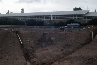
Photograph - Digital Image, Watsonia High School Pool, Construction 1976. Concretee pool and surrounds under construction 2, 12/12/1976
The swimming pool at Watsonia High School was commenced in 1976 and opened in 1977. This photo shows the concrete pool and surrounds under construction with classrooms in background..While the school has gone, the pool remains in 2019, operating as Yarra Swim School, Liat Way GreensboroughDigital copy of colour photograph, scanned from slide. Slide set at Item 6513.watsonia high school, swimming pools greensborough, yarra swim school -
 Greensborough Historical Society
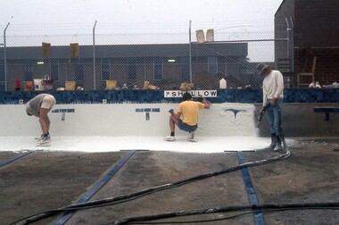
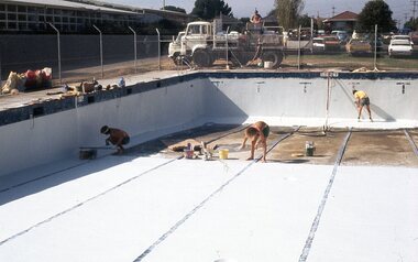
Photograph - Digital Image, Watsonia High School Pool, Construction 1976. Lining the pool 2, 12/12/1976
The swimming pool at Watsonia High School was commenced in 1976 and opened in 1977. This photo shows workers spraying a lining on the concrete pool.While the school has gone, the pool remains in 2019, operating as Yarra Swim School, Liat Way GreensboroughDigital copy of colour photograph, scanned from slide. Slide set at Item 6513.watsonia high school, swimming pools greensborough, yarra swim school -
 Greensborough Historical Society
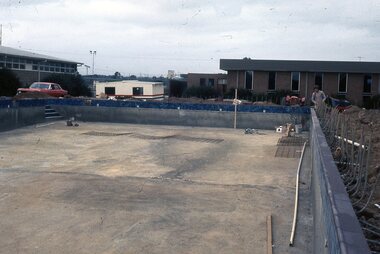
Photograph - Digital Image, Watsonia High School Pool, Construction 1976. Concrete complete, 12/12/1976
... Watsonia High School Pool, Construction 1976. Concrete... Pool, Construction 1976. Concrete complete. Photograph ...The swimming pool at Watsonia High School was commenced in 1976 and opened in 1977. This photo shows the completed concrete base and sides of the pool.While the school has gone, the pool remains in 2019, operating as Yarra Swim School, Liat Way GreensboroughDigital copy of colour photograph, scanned from slide. Slide set at Item 6513.watsonia high school, swimming pools greensborough, yarra swim school -
 Greensborough Historical Society
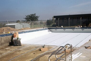
Photograph - Digital Image, Watsonia High School Pool, Construction 1976. Pool lining nearing completion 3, 12/12/1976
The swimming pool at Watsonia High School was commenced in 1976 and opened in 1977. This photo shows a spray lining being applied to the concrete pool.While the school has gone, the pool remains in 2019, operating as Yarra Swim School, Liat Way GreensboroughDigital copy of colour photograph, scanned from slide. Slide set at Item 6513.watsonia high school, swimming pools greensborough, yarra swim school -
 Greensborough Historical Society
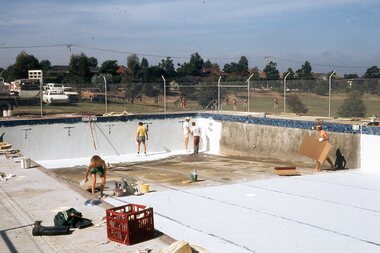
Photograph - Digital Image, Watsonia High School Pool, Construction 1976. Pool lining nearing completion 4, 12/12/1976
The swimming pool at Watsonia High School was commenced in 1976 and opened in 1977. This photo shows a spray lining being applied to the concrete pool.While the school has gone, the pool remains in 2019, operating as Yarra Swim School, Liat Way GreensboroughDigital copy of colour photograph, scanned from slide. Slide set at Item 6513.watsonia high school, swimming pools greensborough, yarra swim school -
 Greensborough Historical Society
Photograph - Digital Image, Watsonia High School Pool, Construction 1976. Pool lining nearing completion 5, 12/12/1976
The swimming pool at Watsonia High School was commenced in 1976 and opened in 1977. This photo shows a spray lining being applied to the concrete pool.While the school has gone, the pool remains in 2019, operating as Yarra Swim School, Liat Way GreensboroughDigital copy of colour photograph, scanned from slide. Slide set at Item 6513.watsonia high school, swimming pools greensborough, yarra swim school -
 Greensborough Historical Society
Photograph - Digital Image, Watsonia High School Pool, Construction 1976. Concrete and tiled edges complete, 12/12/1976
... Watsonia High School Pool, Construction 1976. Concrete and.... Watsonia High School Pool, Construction 1976. Concrete and tiled ...The swimming pool at Watsonia High School was commenced in 1976 and opened in 1977. This photo shows a spray lining being applied to the concrete pool.While the school has gone, the pool remains in 2019, operating as Yarra Swim School, Liat Way GreensboroughDigital copy of colour photograph, scanned from slide. Slide set at Item 6513.watsonia high school, swimming pools greensborough, yarra swim school -
 Greensborough Historical Society
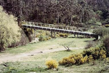
Photograph - Digital Image, Aqueduct Greensborough, 1960c
The Pipe Bridge at Greensborough is a significant and highly visible part of the system. It was constructed to carry the wrought iron aqueduct pipes over the Plenty River. The use of wrought iron meant the pipes were 75% lighter than cast iron, with the bridge construction reflecting this innovation. Photograph of the Maroondah Aqueduct pipe bridge at Greensborough. The Pipe Bridge is 210 feet long, divided into 4 spans. The main girders are light lattice 11 feet deep and 11 ft 4 inches apart. The bridge carried two wrought iron tubular mains, 53 inches in diameter, supported at intervals by cross girders and chairs, placed between the main girders. The bridge is carried on braced cast-iron columns, 18 inches in diameter, set on concrete foundations, with a clear headway of 20 feet above the Plenty River. The eastern side of the bridge is reinforced with a bluestone abutment at the river bank.Digital copy of colour photograph.maroondah aqueduct, aqueduct pipe bridge greensborough -
 Glenelg Shire Council Cultural Collection
Slide - Slide - Construction Portland/Cashmore Airport, c. 1980
Coloured slide. Deep squirish hole, muddy water in bottom. Rough wooden steps down to water, left hand side of hole. Large concrete pipe on right attached to metal structure which is embedded in bottom of hole. -
Glenelg Shire Council Cultural Collection
Slide - Slide - Construction Portland/Cashmore airport, c. 1980
Coloured slide. A diffrent view of the square concrete drain in 5285. -
Glenelg Shire Council Cultural Collection
Photograph - Photograph - Main Breakwater Construction, n.d
Port of Portland Authority Archivesport of portland archives -
Glenelg Shire Council Cultural Collection
Photograph - Photograph - Main Breakwater under Construction, 10/02/1959
... construction. Grid of concrete & concrete piles. Wooden piles along... construction. Grid of concrete & concrete piles. Wooden piles along ...Port of Portland Authority ArchivesBack: Purple stamp '10 Feb 1959'port of portland archives -
Glenelg Shire Council Cultural Collection
Slide - Slide - Construction Portland/Cashmore airport, c. 1980
Coloured slide. View looking at top of square concrete drain set vertically in ground. Grate on right. -
Glenelg Shire Council Cultural Collection
Slide - Slide - Construction Portland/Cashmore Airport, c. 1980
Coloured slide. Same worksite as 5264, 5265. Opening at end of drain visible. Trench has been filled in up both sides of drain, so level. Some concrete form work at mouth of drain. -
Glenelg Shire Council Cultural Collection
Slide - Slide - Cashmore Airport, Portland, 1980s
Coloured slide. Semi-trailer loaded with seven sections of rectangular concrete drain at the Cashmore airport construction site.portland airport, cashmore airport, construction portland development, air travel -
Glenelg Shire Council Cultural Collection
Slide - Slide - Construction Portland/Cashmore Airport, c. 1980
... concrete drain. Slide Slide - Construction Portland/Cashmore ...Coloured slide. Deep trench on left. Several semi-trailers and a crane on rigth of trench. Semi-trailers loaded with sections of rectangular concrete drain. -
Glenelg Shire Council Cultural Collection
Slide - Slide - Cashmore Airport, Portland, 1980s
Coloured slide. Trench with rectangular concrete drain, running north south. The trench is open at the south end.portland airport, cashmore airport, air travel, portland construction, development -
Glenelg Shire Council Cultural Collection
Slide - Slide - Cashmore Airport, Portland, 1980s
Coloured slide. Deep trench with concrete barrier at one end. Cashmore airport construction site.portland airport, cashmore, air travel, portland development, construction -
Glenelg Shire Council Cultural Collection
Slide - Slide - Cashmore Airport, Portland, 1980s
Coloured slide. Concrete retaining wall at end of trench. Tunnel through concrete to allow water flow. Cashmore airport construction site.portland airport, cashmore airport, air travel, development -
Glenelg Shire Council Cultural Collection
Slide - Slide - Cashmore Airport, Portland, 1980s
Coloured slide. Three people standing to left of drain full of water. Concrete slab across drain. Roller on right. Cashmore airport construction.portland airport, cashmore, engineering, construction, portland development -
Glenelg Shire Council Cultural Collection
Photograph - Photograph - Portland Library, Victoria, 26/08/1999
Photographs of Portland Library - late 1990s to early 2000s, showing activities at the library and construction of additions to the building.Coloured photo. Portland Library. Woman sweeping concrete outside entrance.Front: '99 8 26'