Showing 157 items
matching cultural landscape
-
 Friends of Ballarat Botanical Gardens History Group
Work on paper - Victoria Park Precinct, City of Ballarat, Victorian Heritage Database place details -19/9/2017, 19/9/2017
... cultural landscape" in the city of Ballarat. This parkland ...Victoria Park is associated with gold mining in the 1860's, military manoevres in the late 19th century; as an army base during World War 2 and a recreation area.Victoria Park is a "landmark cultural landscape" in the city of Ballarat. This parkland established 1890-1910, was modelled on English country estates and London Parks. It demonstrates the civic pride of Ballarat citizens and is an important parkland for the local community. There is a collection of exotic and early planted native trees and areas of native grasslands.6 pages of print. p.1. is a front page with a map and Victoria Park marked in purple with a bibliography on p.4 and footnotes on p.6.None.john garner, victoria park, friends of ballarat botanical gardens, heritage overlay, gold mining, parkland, late nineteenth century, native grasslands, exotic and native trees, royal park, mullock heap, mount holled-smith, arbor day, messrs clegg&nicholls, william guilfoyle, w.o.allen, significant tree register, john garner collection, gardens, ballarat -
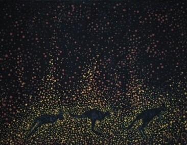 City of Whittlesea Art Collection
Painting - Acrylic on canvas, Bushfire, 2020
Acquired from the artist for Council's Cultural Collection in June 2022MVRbushfire in the australian landscape -
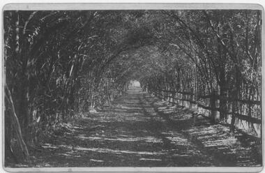 Bacchus Marsh & District Historical Society
Photograph, Osage Orange Avenue Taverner Street Bacchus Marsh
A.C. (Arthur Charles) Simon a pioneer orchardist in the Bacchus Marsh district planted this avenue of Osage orange trees in about 1883, creating an imposing entrance to his property from Taverner Street. Simon also believed that the trees on his orchard property would provide a protective shelter for his other plants. Osage orange trees (Maclura pomifera) are a small deciduous tree or large shrub, native to the south-central United States. It usually grows to about 8 to 15 metres high. The distinctive fruit, a multiple fruit that resembles an immature orange, is roughly spherical in shape, about 8 to 15 centimetres in diameter, and turns bright yellow-green in the autumn. A. C. Simon is believed to have imported the Osage orange seeds from America around the 1860s and later used them to plant the trees depicted in this image. The date of this image is not certain but it probably shows the trees around the 1900s or 1910s. The avenue of trees was known for many years in Bacchus Mars as 'Simons Avenue', and were featured in a Rose series postcard dating from around 1900-1920. The remnants of this avenue or grove of trees can be seen on some of the properties on the north side of Taverner Street Bacchus Marsh and along the Werribee River west of the FIsken Street bridge.The Bacchus Marsh Heritage Study of 1995 described the Osage Orange Tree avenue as being of regional historical significance as a landscaping practice, pioneering of its type, It was also described as of local significance as a well-known landmark due to it be being represented on widely distributed post cards which depicted scenes of Bacchus Marsh in the early part of the twentieth century. This early photographic image is evidence of this social and cultural significance.A black and white photograph print mounted on mounting board showing an avenue of Osage orange trees. trees, osage orange trees, simon family bacchus marsh, arthur charles simon 1833-1924, orchardists -
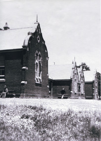 The Beechworth Burke Museum
Photograph, c. 1900
This black and white photograph shows the front view of the Ovens Benevolent Home with one person sitting on a bench seat against the nearest part of the building and another person walking on the grass. This photo is estimated to have been taken in the early 1900’s when the Ovens Benevolent home would have still been fairly contemporary. According to Woods (p. 121) in the 1860’s the government spent considerable sums to establish several public buildings such as the Benevolent Asylum, the Hospital and Insane Asylum to support those in need of care in the area directly after the Indigo gold rush which had left Beechworth, a fairly remote regional and newly formed township (Gold was first discovered in Beechworth in 1852) with a number of infirm and destitute people in its wake and which due to the support and establishment of these facilities ‘made Beechworth a significant social welfare centre in Victoria’ (Woods, p. 121). Originally named the Benevolent Asylum, the building was renamed as The Ovens Benevolent Asylum in 1935 and again to The Ovens and Murray Home in 1954. The building construction began in 1862 and was unique in its features of Flemish Gothic Revival style which utilised red brick and granite, ‘the main facade is dominated by four curved, Flemish gable ends, […] incorporates paired windows of pointed Gothic form and dark brick diaperwork patterning. The adjacent J. A. Wallace Wing of 1899 was designed by Donald Fiddes as a separate building. Also constructed of red brick, Fiddes adopted a conservative approach, designing a simple domestic scale building with central projecting gable porch and flanking bull nosed verandahs.’ (https://vhd.heritagecouncil.vic.gov.au/places/118). Initially established to provide housing and care for aged, orphaned or widowed members of the population, over time the Ovens Benevolent Home focused more on the age care responsibility which functioned as such up until 2005.The Ovens Benevolent Home is significance due to its association with the early development of Beechworth. It shows the civic, social welfare development that took place in the town after the peak of the gold rush which helps to establish the character of the community being built at the time and their cultural values at play. This photograph also clearly shows the early functioning landscape of that building and its purpose as well as the significant elements of its aesthetic significance and unique and striking architectural forms of the building.Black and white rectangular photograph [copy from slide]Reverse: / 7588 /housing and care, aged care, donald fiddes, ovens benevolent home, flemish gable, brick diaperwork, photograph, black and white photograph, public building, benevolent asylum, indigo gold rush, beechworth, the ovens and murray home -
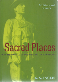 Warrnambool and District Historical Society Inc.
Book, Kenneth Stanley Inglis, Sacred Places War Memorials in the Australian Landscape
This book looks at the war memorials in Australia and traces the development of the Anzac cult and the reasons that the war memorials are increasingly cherished in Australian society. It is an important treatise on a unique aspect of Australia cultural life.This is a paperback book of 521 pages. The cover is multi-coloured with an image of an Australian soldier on the front and spine.non-fictionThis book looks at the war memorials in Australia and traces the development of the Anzac cult and the reasons that the war memorials are increasingly cherished in Australian society. It is an important treatise on a unique aspect of Australia cultural life.war memorials in australia, monuments -
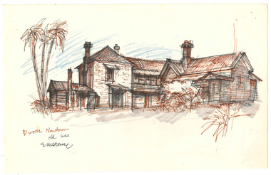 The Beechworth Burke Museum
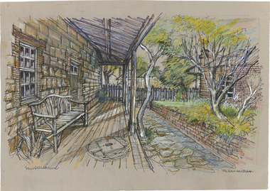
Drawing, Ernest Marcuse, Beechworth Newtown, c1983
Ernest Heinrich Marcuse was born on the 1st of December 1900 to Hedwig and Siegmund Marcuse in Berlin Germany. While Marcuse's artistic talent was apparent from a younger age, his earliest existing artwork was from when he was approximately 20 years old. Ernest's formal art training commenced in 1918 with a three year course at the Berlin school of Interior design. After completion he found work until 1924 when Germany's Great Depression took effect. To broaden his career opportunities he undertook a further 12 months study of fashion, drawing and advertising at Berlin's Reiman school of art. From 1925 to 1934 Ernest was primarily a freelance press artist specialising in industrial, architectural and figurative drawing. Prominent newspaper The Berliner Morgenpost was his largest client along with Gross Deutsche Rundfunaustellung (Germany's organisation for major trade shows). During this period he would create many significant works. Two months after Hitler and the Nazi part came to power in 1933, Ernest received a life changing letter stating that being Jewish he could no longer continue employment in Germany. Up until 1938 he would only be able to undertake private commissions and occasional unofficial work as a book illustrator and games designer. This was by arrangement with non Jewish artists who claimed his work as their own, they would then share the income with Ernest. With increasing unrest in Germany during late 1938 Ernest decided to move to London and there he married his girlfriend Lotte. In late 1939 Ernest and Lotte Marcuse embarked on an eight week journey to their new home in Australia where they had been accepted as refugees. Shortly after arriving in Australia Ernest presented his portfolio to an editor at the Argus newspaper and gained employment as a war events illustrator. He soon became well respected and known in particular for his detailed illustrations and cross sections of ships , artillery and aircrafts. His detailed depictions of battles were displayed on the front pages of The Argus newspaper on a number of occasions. In May 1940 as the war intensified Ernest was dismissed from The Argus newspaper due to his Australian government classification of 'stateless person of enemy origin' and was considered a potential security risk. The editor of the time commented "don't blame us, blame Hitler". Marcuse then began to establish himself as a commercial artist. Ernest was de-classified as a 'stateless person of enemy origin' and in early 1942. The Australian army heard of Ernest's artistic abilities and began to utilize his designs for visual training aids and posters. Ernest became Private E.H Marcuse V377746, his first army posting was as staff artist at The infantry officer's training school at Bonegilla. When off duty he was inspired by the beauty of the surrounding area creating the works in North east Victoria 'Kiewa river bridge', 'Hume weir', ' Dried up river bed' and 'Hawksview gold reef mine' from his 1942-1943 period at Bonegilla Victoria. Ernest returned to the area to create drawings and paintings from 1948 to 1983 in locations including Bright, Wandilligong, Bogong High plains and Wallace's Hut, Mt Buffalo, Beechworth, Pretty valley, Kiewa Hydro, Yackandandah and Bontherambo homestead. These sketches were often completed on location, photographs were also taken onsite to assist the works back at the studio. Occasionally Marcuse also painted in the field. Ernest's preferred choice of medium was pencil and ink. Up until 1952 he would often incorporate watercolour into his work. Later into his career he began introducing pastels, acrylic and mixed media. In earlier years Ernest Marcuse often signed his work Mar, later on the signing of works ranged from Marcuse, E.Marcuse, Ernest Marcuse, EHM or simply EM . If a work was considered incomplete or Marcuse did not like the work it would remain unsigned. From Bonegilla Marcuse was transferred to Woodside South Australia before his final posting in Melbourne until the end of 1945. Ernest's work from within his army posting 'Troop Train at Night' from his 1945 exhibition Australia at War are part of the permanent collection at Canberra's War Museum. Between 1946 and 1969 Ernest largely worked from home and concentrated on a career as a freelance commercial artist and graphic designer. During that time he created work for well known household names including CRA/Conzinc, Vacuum oil (Caltex), Cottee's Brand (Schweppes and Heinz), Home Beautiful magazine Fulton garden supplies, International Iveco trucks, Ego pharmaceuticals, QV and Sunsense. After retirement Ernest concentrated on his true love of fine art and focused on painting images of personal interest both across Australia and Internationally. Earnest never drove a car. He would often walk or use public transport or enlist in the help of family or artist friends to drive him. Throughout his career Ernest Marcuse's artworks were purchase by private collectors these included ACTU, Melbourne City council, Holland Constructions, Melbourne Metropolitan Tramways Board, GJ Coles and Australian Resources Bank. Ernest Marcuse permanent collections can be viewed at The National Gallery of Victoria , Sydney Jewish Museum, Jewish Holocaust Centre Melbourne, Canberra's War Museum, City of Melbourne, Shire of Yarra ranges and now the Burke Museum. © 2020 Art by Marcuse https://www.artbymarcuse.com.au/aboutDonated to the Burke Museum through the Australian Government's Cultural Gifts Program by Peter and Evelyn MarcusePen and pencil landscape drawing on paper.Obverse: B'WORTH NEWTOWN / OLD HOUSE / E MARCUSE Reverse: B 11/ 023 / BEECHWORTH NOSTALGIA / BW - 04 ernest marcuse, marcuse, art, artbymarcuse, beechworth, burke museum, indigo shire, landscape, illustration, drawing, pen and pencil, australian army, war events illustrator, the age, the sun, the argus, germany, refugee, industrial drawing, architectual drawing, figure drawing, berliner morgenpost, grosse deutsche rundfunaustellung, berlin’s reiman school of art., cultural gifts program -
 The Beechworth Burke Museum
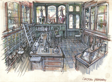
Drawing, Ernest Marcuse, Chiltern, c1983
Ernest Heinrich Marcuse was born on the 1st of December 1900 to Hedwig and Siegmund Marcuse in Berlin Germany. While Marcuse's artistic talent was apparent from a younger age, his earliest existing artwork was from when he was approximately 20 years old. Ernest's formal art training commenced in 1918 with a three year course at the Berlin school of Interior design. After completion he found work until 1924 when Germany's Great Depression took effect. To broaden his career opportunities he undertook a further 12 months study of fashion, drawing and advertising at Berlin's Reiman school of art. From 1925 to 1934 Ernest was primarily a freelance press artist specialising in industrial, architectural and figurative drawing. Prominent newspaper The Berliner Morgenpost was his largest client along with Gross Deutsche Rundfunaustellung (Germany's organisation for major trade shows). During this period he would create many significant works. Two months after Hitler and the Nazi part came to power in 1933, Ernest received a life changing letter stating that being Jewish he could no longer continue employment in Germany. Up until 1938 he would only be able to undertake private commissions and occasional unofficial work as a book illustrator and games designer. This was by arrangement with non Jewish artists who claimed his work as their own, they would then share the income with Ernest. With increasing unrest in Germany during late 1938 Ernest decided to move to London and there he married his girlfriend Lotte. In late 1939 Ernest and Lotte Marcuse embarked on an eight week journey to their new home in Australia where they had been accepted as refugees. Shortly after arriving in Australia Ernest presented his portfolio to an editor at the Argus newspaper and gained employment as a war events illustrator. He soon became well respected and known in particular for his detailed illustrations and cross sections of ships , artillery and aircrafts. His detailed depictions of battles were displayed on the front pages of The Argus newspaper on a number of occasions. In May 1940 as the war intensified Ernest was dismissed from The Argus newspaper due to his Australian government classification of 'stateless person of enemy origin' and was considered a potential security risk. The editor of the time commented "don't blame us, blame Hitler". Marcuse then began to establish himself as a commercial artist. Ernest was de-classified as a 'stateless person of enemy origin' and in early 1942. The Australian army heard of Ernest's artistic abilities and began to utilize his designs for visual training aids and posters. Ernest became Private E.H Marcuse V377746, his first army posting was as staff artist at The infantry officer's training school at Bonegilla. When off duty he was inspired by the beauty of the surrounding area creating the works in North east Victoria 'Kiewa river bridge', 'Hume weir', ' Dried up river bed' and 'Hawksview gold reef mine' from his 1942-1943 period at Bonegilla Victoria. Ernest returned to the area to create drawings and paintings from 1948 to 1983 in locations including Bright, Wandilligong, Bogong High plains and Wallace's Hut, Mt Buffalo, Beechworth, Pretty valley, Kiewa Hydro, Yackandandah and Bontherambo homestead. These sketches were often completed on location, photographs were also taken onsite to assist the works back at the studio. Occasionally Marcuse also painted in the field. Ernest's preferred choice of medium was pencil and ink. Up until 1952 he would often incorporate watercolour into his work. Later into his career he began introducing pastels, acrylic and mixed media. In earlier years Ernest Marcuse often signed his work Mar, later on the signing of works ranged from Marcuse, E.Marcuse, Ernest Marcuse, EHM or simply EM . If a work was considered incomplete or Marcuse did not like the work it would remain unsigned. From Bonegilla Marcuse was transferred to Woodside South Australia before his final posting in Melbourne until the end of 1945. Ernest's work from within his army posting 'Troop Train at Night' from his 1945 exhibition Australia at War are part of the permanent collection at Canberra's War Museum. Between 1946 and 1969 Ernest largely worked from home and concentrated on a career as a freelance commercial artist and graphic designer. During that time he created work for well known household names including CRA/Conzinc, Vacuum oil (Caltex), Cottee's Brand (Schweppes and Heinz), Home Beautiful magazine Fulton garden supplies, International Iveco trucks, Ego pharmaceuticals, QV and Sunsense. After retirement Ernest concentrated on his true love of fine art and focused on painting images of personal interest both across Australia and Internationally. Earnest never drove a car. He would often walk or use public transport or enlist in the help of family or artist friends to drive him. Throughout his career Ernest Marcuse's artworks were purchase by private collectors these included ACTU, Melbourne City council, Holland Constructions, Melbourne Metropolitan Tramways Board, GJ Coles and Australian Resources Bank. Ernest Marcuse permanent collections can be viewed at The National Gallery of Victoria , Sydney Jewish Museum, Jewish Holocaust Centre Melbourne, Canberra's War Museum, City of Melbourne, Shire of Yarra ranges and now the Burke Museum. © 2020 Art by Marcuse https://www.artbymarcuse.com.au/aboutDonated to the Burke Museum through the Australian Government's Cultural Gifts Program by Peter and Evelyn MarcusePen and pencil landscape drawing on paper.Obverse: Reverse: CHILTERN ? / (SAME (illegible), SAME PAPER + COLOURS AS CHILTERN PHARMACY / BOTH MAY HAVE BEEN 1981 WHEN IN YACKANDANDAH? / ernest marcuse, marcuse, art, artbymarcuse, beechworth, burke museum, indigo shire, landscape, illustration, drawing, pen and pencil, australian army, war events illustrator, the age, the sun, the argus, germany, refugee, industrial drawing, architectual drawing, figure drawing, berliner morgenpost, grosse deutsche rundfunaustellung, berlin’s reiman school of art., cultural gifts program -
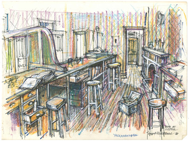
 The Beechworth Burke Museum
Drawing, Ernest Marcuse, Yackandandah II, c1983
Ernest Heinrich Marcuse was born on the 1st of December 1900 to Hedwig and Siegmund Marcuse in Berlin Germany. While Marcuse's artistic talent was apparent from a younger age, his earliest existing artwork was from when he was approximately 20 years old. Ernest's formal art training commenced in 1918 with a three year course at the Berlin school of Interior design. After completion he found work until 1924 when Germany's Great Depression took effect. To broaden his career opportunities he undertook a further 12 months study of fashion, drawing and advertising at Berlin's Reiman school of art. From 1925 to 1934 Ernest was primarily a freelance press artist specialising in industrial, architectural and figurative drawing. Prominent newspaper The Berliner Morgenpost was his largest client along with Gross Deutsche Rundfunaustellung (Germany's organisation for major trade shows). During this period he would create many significant works. Two months after Hitler and the Nazi part came to power in 1933, Ernest received a life changing letter stating that being Jewish he could no longer continue employment in Germany. Up until 1938 he would only be able to undertake private commissions and occasional unofficial work as a book illustrator and games designer. This was by arrangement with non Jewish artists who claimed his work as their own, they would then share the income with Ernest. With increasing unrest in Germany during late 1938 Ernest decided to move to London and there he married his girlfriend Lotte. In late 1939 Ernest and Lotte Marcuse embarked on an eight week journey to their new home in Australia where they had been accepted as refugees. Shortly after arriving in Australia Ernest presented his portfolio to an editor at the Argus newspaper and gained employment as a war events illustrator. He soon became well respected and known in particular for his detailed illustrations and cross sections of ships , artillery and aircrafts. His detailed depictions of battles were displayed on the front pages of The Argus newspaper on a number of occasions. In May 1940 as the war intensified Ernest was dismissed from The Argus newspaper due to his Australian government classification of 'stateless person of enemy origin' and was considered a potential security risk. The editor of the time commented "don't blame us, blame Hitler". Marcuse then began to establish himself as a commercial artist. Ernest was de-classified as a 'stateless person of enemy origin' and in early 1942. The Australian army heard of Ernest's artistic abilities and began to utilize his designs for visual training aids and posters. Ernest became Private E.H Marcuse V377746, his first army posting was as staff artist at The infantry officer's training school at Bonegilla. When off duty he was inspired by the beauty of the surrounding area creating the works in North east Victoria 'Kiewa river bridge', 'Hume weir', ' Dried up river bed' and 'Hawksview gold reef mine' from his 1942-1943 period at Bonegilla Victoria. Ernest returned to the area to create drawings and paintings from 1948 to 1983 in locations including Bright, Wandilligong, Bogong High plains and Wallace's Hut, Mt Buffalo, Beechworth, Pretty valley, Kiewa Hydro, Yackandandah and Bontherambo homestead. These sketches were often completed on location, photographs were also taken onsite to assist the works back at the studio. Occasionally Marcuse also painted in the field. Ernest's preferred choice of medium was pencil and ink. Up until 1952 he would often incorporate watercolour into his work. Later into his career he began introducing pastels, acrylic and mixed media. In earlier years Ernest Marcuse often signed his work Mar, later on the signing of works ranged from Marcuse, E.Marcuse, Ernest Marcuse, EHM or simply EM . If a work was considered incomplete or Marcuse did not like the work it would remain unsigned. From Bonegilla Marcuse was transferred to Woodside South Australia before his final posting in Melbourne until the end of 1945. Ernest's work from within his army posting 'Troop Train at Night' from his 1945 exhibition Australia at War are part of the permanent collection at Canberra's War Museum. Between 1946 and 1969 Ernest largely worked from home and concentrated on a career as a freelance commercial artist and graphic designer. During that time he created work for well known household names including CRA/Conzinc, Vacuum oil (Caltex), Cottee's Brand (Schweppes and Heinz), Home Beautiful magazine Fulton garden supplies, International Iveco trucks, Ego pharmaceuticals, QV and Sunsense. After retirement Ernest concentrated on his true love of fine art and focused on painting images of personal interest both across Australia and Internationally. Earnest never drove a car. He would often walk or use public transport or enlist in the help of family or artist friends to drive him. Throughout his career Ernest Marcuse's artworks were purchase by private collectors these included ACTU, Melbourne City council, Holland Constructions, Melbourne Metropolitan Tramways Board, GJ Coles and Australian Resources Bank. Ernest Marcuse permanent collections can be viewed at The National Gallery of Victoria , Sydney Jewish Museum, Jewish Holocaust Centre Melbourne, Canberra's War Museum, City of Melbourne, Shire of Yarra ranges and now the Burke Museum. © 2020 Art by Marcuse https://www.artbymarcuse.com.au/aboutDonated to the Burke Museum through the Australian Government's Cultural Gifts Program by Peter and Evelyn MarcusePen and pencil landscape drawing on paper.Obverse: YACKANDANDAH / MARCUSE / 83 Reverse: YACKANDANDAH / Y 911/ 022 ernest marcuse, marcuse, art, artbymarcuse, beechworth, burke museum, indigo shire, landscape, illustration, drawing, pen and pencil, australian army, war events illustrator, the age, the sun, the argus, germany, refugee, industrial drawing, architectual drawing, figure drawing, berliner morgenpost, grosse deutsche rundfunaustellung, berlin’s reiman school of art., cultural gifts program -
 The Beechworth Burke Museum
Drawing, Ernest Marcuse, Yackandandah III, c1983
Ernest Heinrich Marcuse was born on the 1st of December 1900 to Hedwig and Siegmund Marcuse in Berlin Germany. While Marcuse's artistic talent was apparent from a younger age, his earliest existing artwork was from when he was approximately 20 years old. Ernest's formal art training commenced in 1918 with a three year course at the Berlin school of Interior design. After completion he found work until 1924 when Germany's Great Depression took effect. To broaden his career opportunities he undertook a further 12 months study of fashion, drawing and advertising at Berlin's Reiman school of art. From 1925 to 1934 Ernest was primarily a freelance press artist specialising in industrial, architectural and figurative drawing. Prominent newspaper The Berliner Morgenpost was his largest client along with Gross Deutsche Rundfunaustellung (Germany's organisation for major trade shows). During this period he would create many significant works. Two months after Hitler and the Nazi part came to power in 1933, Ernest received a life changing letter stating that being Jewish he could no longer continue employment in Germany. Up until 1938 he would only be able to undertake private commissions and occasional unofficial work as a book illustrator and games designer. This was by arrangement with non Jewish artists who claimed his work as their own, they would then share the income with Ernest. With increasing unrest in Germany during late 1938 Ernest decided to move to London and there he married his girlfriend Lotte. In late 1939 Ernest and Lotte Marcuse embarked on an eight week journey to their new home in Australia where they had been accepted as refugees. Shortly after arriving in Australia Ernest presented his portfolio to an editor at the Argus newspaper and gained employment as a war events illustrator. He soon became well respected and known in particular for his detailed illustrations and cross sections of ships , artillery and aircrafts. His detailed depictions of battles were displayed on the front pages of The Argus newspaper on a number of occasions. In May 1940 as the war intensified Ernest was dismissed from The Argus newspaper due to his Australian government classification of 'stateless person of enemy origin' and was considered a potential security risk. The editor of the time commented "don't blame us, blame Hitler". Marcuse then began to establish himself as a commercial artist. Ernest was de-classified as a 'stateless person of enemy origin' and in early 1942. The Australian army heard of Ernest's artistic abilities and began to utilize his designs for visual training aids and posters. Ernest became Private E.H Marcuse V377746, his first army posting was as staff artist at The infantry officer's training school at Bonegilla. When off duty he was inspired by the beauty of the surrounding area creating the works in North east Victoria 'Kiewa river bridge', 'Hume weir', ' Dried up river bed' and 'Hawksview gold reef mine' from his 1942-1943 period at Bonegilla Victoria. Ernest returned to the area to create drawings and paintings from 1948 to 1983 in locations including Bright, Wandilligong, Bogong High plains and Wallace's Hut, Mt Buffalo, Beechworth, Pretty valley, Kiewa Hydro, Yackandandah and Bontherambo homestead. These sketches were often completed on location, photographs were also taken onsite to assist the works back at the studio. Occasionally Marcuse also painted in the field. Ernest's preferred choice of medium was pencil and ink. Up until 1952 he would often incorporate watercolour into his work. Later into his career he began introducing pastels, acrylic and mixed media. In earlier years Ernest Marcuse often signed his work Mar, later on the signing of works ranged from Marcuse, E.Marcuse, Ernest Marcuse, EHM or simply EM . If a work was considered incomplete or Marcuse did not like the work it would remain unsigned. From Bonegilla Marcuse was transferred to Woodside South Australia before his final posting in Melbourne until the end of 1945. Ernest's work from within his army posting 'Troop Train at Night' from his 1945 exhibition Australia at War are part of the permanent collection at Canberra's War Museum. Between 1946 and 1969 Ernest largely worked from home and concentrated on a career as a freelance commercial artist and graphic designer. During that time he created work for well known household names including CRA/Conzinc, Vacuum oil (Caltex), Cottee's Brand (Schweppes and Heinz), Home Beautiful magazine Fulton garden supplies, International Iveco trucks, Ego pharmaceuticals, QV and Sunsense. After retirement Ernest concentrated on his true love of fine art and focused on painting images of personal interest both across Australia and Internationally. Earnest never drove a car. He would often walk or use public transport or enlist in the help of family or artist friends to drive him. Throughout his career Ernest Marcuse's artworks were purchase by private collectors these included ACTU, Melbourne City council, Holland Constructions, Melbourne Metropolitan Tramways Board, GJ Coles and Australian Resources Bank. Ernest Marcuse permanent collections can be viewed at The National Gallery of Victoria , Sydney Jewish Museum, Jewish Holocaust Centre Melbourne, Canberra's War Museum, City of Melbourne, Shire of Yarra ranges and now the Burke Museum. © 2020 Art by Marcuse https://www.artbymarcuse.com.au/aboutDonated to the Burke Museum through the Australian Government's Cultural Gifts Program by Peter and Evelyn MarcusePen and pencil landscape drawing on paper.Obverse: Reverse: YACKANDANDAH / Y 9 / 021 ernest marcuse, marcuse, art, artbymarcuse, beechworth, burke museum, indigo shire, landscape, illustration, drawing, pen and pencil, australian army, war events illustrator, the age, the sun, the argus, germany, refugee, industrial drawing, architectual drawing, figure drawing, berliner morgenpost, grosse deutsche rundfunaustellung, berlin’s reiman school of art., cultural gifts program -
 The Beechworth Burke Museum
Drawing, Ernest Marcuse, Yackandandah IV, c1983
Ernest Heinrich Marcuse was born on the 1st of December 1900 to Hedwig and Siegmund Marcuse in Berlin Germany. While Marcuse's artistic talent was apparent from a younger age, his earliest existing artwork was from when he was approximately 20 years old. Ernest's formal art training commenced in 1918 with a three year course at the Berlin school of Interior design. After completion he found work until 1924 when Germany's Great Depression took effect. To broaden his career opportunities he undertook a further 12 months study of fashion, drawing and advertising at Berlin's Reiman school of art. From 1925 to 1934 Ernest was primarily a freelance press artist specialising in industrial, architectural and figurative drawing. Prominent newspaper The Berliner Morgenpost was his largest client along with Gross Deutsche Rundfunaustellung (Germany's organisation for major trade shows). During this period he would create many significant works. Two months after Hitler and the Nazi part came to power in 1933, Ernest received a life changing letter stating that being Jewish he could no longer continue employment in Germany. Up until 1938 he would only be able to undertake private commissions and occasional unofficial work as a book illustrator and games designer. This was by arrangement with non Jewish artists who claimed his work as their own, they would then share the income with Ernest. With increasing unrest in Germany during late 1938 Ernest decided to move to London and there he married his girlfriend Lotte. In late 1939 Ernest and Lotte Marcuse embarked on an eight week journey to their new home in Australia where they had been accepted as refugees. Shortly after arriving in Australia Ernest presented his portfolio to an editor at the Argus newspaper and gained employment as a war events illustrator. He soon became well respected and known in particular for his detailed illustrations and cross sections of ships , artillery and aircrafts. His detailed depictions of battles were displayed on the front pages of The Argus newspaper on a number of occasions. In May 1940 as the war intensified Ernest was dismissed from The Argus newspaper due to his Australian government classification of 'stateless person of enemy origin' and was considered a potential security risk. The editor of the time commented "don't blame us, blame Hitler". Marcuse then began to establish himself as a commercial artist. Ernest was de-classified as a 'stateless person of enemy origin' and in early 1942. The Australian army heard of Ernest's artistic abilities and began to utilize his designs for visual training aids and posters. Ernest became Private E.H Marcuse V377746, his first army posting was as staff artist at The infantry officer's training school at Bonegilla. When off duty he was inspired by the beauty of the surrounding area creating the works in North east Victoria 'Kiewa river bridge', 'Hume weir', ' Dried up river bed' and 'Hawksview gold reef mine' from his 1942-1943 period at Bonegilla Victoria. Ernest returned to the area to create drawings and paintings from 1948 to 1983 in locations including Bright, Wandilligong, Bogong High plains and Wallace's Hut, Mt Buffalo, Beechworth, Pretty valley, Kiewa Hydro, Yackandandah and Bontherambo homestead. These sketches were often completed on location, photographs were also taken onsite to assist the works back at the studio. Occasionally Marcuse also painted in the field. Ernest's preferred choice of medium was pencil and ink. Up until 1952 he would often incorporate watercolour into his work. Later into his career he began introducing pastels, acrylic and mixed media. In earlier years Ernest Marcuse often signed his work Mar, later on the signing of works ranged from Marcuse, E.Marcuse, Ernest Marcuse, EHM or simply EM . If a work was considered incomplete or Marcuse did not like the work it would remain unsigned. From Bonegilla Marcuse was transferred to Woodside South Australia before his final posting in Melbourne until the end of 1945. Ernest's work from within his army posting 'Troop Train at Night' from his 1945 exhibition Australia at War are part of the permanent collection at Canberra's War Museum. Between 1946 and 1969 Ernest largely worked from home and concentrated on a career as a freelance commercial artist and graphic designer. During that time he created work for well known household names including CRA/Conzinc, Vacuum oil (Caltex), Cottee's Brand (Schweppes and Heinz), Home Beautiful magazine Fulton garden supplies, International Iveco trucks, Ego pharmaceuticals, QV and Sunsense. After retirement Ernest concentrated on his true love of fine art and focused on painting images of personal interest both across Australia and Internationally. Earnest never drove a car. He would often walk or use public transport or enlist in the help of family or artist friends to drive him. Throughout his career Ernest Marcuse's artworks were purchase by private collectors these included ACTU, Melbourne City council, Holland Constructions, Melbourne Metropolitan Tramways Board, GJ Coles and Australian Resources Bank. Ernest Marcuse permanent collections can be viewed at The National Gallery of Victoria , Sydney Jewish Museum, Jewish Holocaust Centre Melbourne, Canberra's War Museum, City of Melbourne, Shire of Yarra ranges and now the Burke Museum. © 2020 Art by Marcuse https://www.artbymarcuse.com.au/aboutDonated to the Burke Museum through the Australian Government's Cultural Gifts Program by Peter and Evelyn MarcusePen and pencil landscape drawing on paper.Obverse: Marcuse / YACKANDANDAH / Reverse: YACKANDANDAH / Y 8 / 020 ernest marcuse, marcuse, art, artbymarcuse, beechworth, burke museum, indigo shire, landscape, illustration, drawing, pen and pencil, australian army, war events illustrator, the age, the sun, the argus, germany, refugee, industrial drawing, architectual drawing, figure drawing, berliner morgenpost, grosse deutsche rundfunaustellung, berlin’s reiman school of art., cultural gifts program -
 The Beechworth Burke Museum
Drawing, Ernest Marcuse, Chiltern, c1983
Ernest Heinrich Marcuse was born on the 1st of December 1900 to Hedwig and Siegmund Marcuse in Berlin Germany. While Marcuse's artistic talent was apparent from a younger age, his earliest existing artwork was from when he was approximately 20 years old. Ernest's formal art training commenced in 1918 with a three year course at the Berlin school of Interior design. After completion he found work until 1924 when Germany's Great Depression took effect. To broaden his career opportunities he undertook a further 12 months study of fashion, drawing and advertising at Berlin's Reiman school of art. From 1925 to 1934 Ernest was primarily a freelance press artist specialising in industrial, architectural and figurative drawing. Prominent newspaper The Berliner Morgenpost was his largest client along with Gross Deutsche Rundfunaustellung (Germany's organisation for major trade shows). During this period he would create many significant works. Two months after Hitler and the Nazi part came to power in 1933, Ernest received a life changing letter stating that being Jewish he could no longer continue employment in Germany. Up until 1938 he would only be able to undertake private commissions and occasional unofficial work as a book illustrator and games designer. This was by arrangement with non Jewish artists who claimed his work as their own, they would then share the income with Ernest. With increasing unrest in Germany during late 1938 Ernest decided to move to London and there he married his girlfriend Lotte. In late 1939 Ernest and Lotte Marcuse embarked on an eight week journey to their new home in Australia where they had been accepted as refugees. Shortly after arriving in Australia Ernest presented his portfolio to an editor at the Argus newspaper and gained employment as a war events illustrator. He soon became well respected and known in particular for his detailed illustrations and cross sections of ships , artillery and aircrafts. His detailed depictions of battles were displayed on the front pages of The Argus newspaper on a number of occasions. In May 1940 as the war intensified Ernest was dismissed from The Argus newspaper due to his Australian government classification of 'stateless person of enemy origin' and was considered a potential security risk. The editor of the time commented "don't blame us, blame Hitler". Marcuse then began to establish himself as a commercial artist. Ernest was de-classified as a 'stateless person of enemy origin' and in early 1942. The Australian army heard of Ernest's artistic abilities and began to utilize his designs for visual training aids and posters. Ernest became Private E.H Marcuse V377746, his first army posting was as staff artist at The infantry officer's training school at Bonegilla. When off duty he was inspired by the beauty of the surrounding area creating the works in North east Victoria 'Kiewa river bridge', 'Hume weir', ' Dried up river bed' and 'Hawksview gold reef mine' from his 1942-1943 period at Bonegilla Victoria. Ernest returned to the area to create drawings and paintings from 1948 to 1983 in locations including Bright, Wandilligong, Bogong High plains and Wallace's Hut, Mt Buffalo, Beechworth, Pretty valley, Kiewa Hydro, Yackandandah and Bontherambo homestead. These sketches were often completed on location, photographs were also taken onsite to assist the works back at the studio. Occasionally Marcuse also painted in the field. Ernest's preferred choice of medium was pencil and ink. Up until 1952 he would often incorporate watercolour into his work. Later into his career he began introducing pastels, acrylic and mixed media. In earlier years Ernest Marcuse often signed his work Mar, later on the signing of works ranged from Marcuse, E.Marcuse, Ernest Marcuse, EHM or simply EM . If a work was considered incomplete or Marcuse did not like the work it would remain unsigned. From Bonegilla Marcuse was transferred to Woodside South Australia before his final posting in Melbourne until the end of 1945. Ernest's work from within his army posting 'Troop Train at Night' from his 1945 exhibition Australia at War are part of the permanent collection at Canberra's War Museum. Between 1946 and 1969 Ernest largely worked from home and concentrated on a career as a freelance commercial artist and graphic designer. During that time he created work for well known household names including CRA/Conzinc, Vacuum oil (Caltex), Cottee's Brand (Schweppes and Heinz), Home Beautiful magazine Fulton garden supplies, International Iveco trucks, Ego pharmaceuticals, QV and Sunsense. After retirement Ernest concentrated on his true love of fine art and focused on painting images of personal interest both across Australia and Internationally. Earnest never drove a car. He would often walk or use public transport or enlist in the help of family or artist friends to drive him. Throughout his career Ernest Marcuse's artworks were purchase by private collectors these included ACTU, Melbourne City council, Holland Constructions, Melbourne Metropolitan Tramways Board, GJ Coles and Australian Resources Bank. Ernest Marcuse permanent collections can be viewed at The National Gallery of Victoria , Sydney Jewish Museum, Jewish Holocaust Centre Melbourne, Canberra's War Museum, City of Melbourne, Shire of Yarra ranges and now the Burke Museum. © 2020 Art by Marcuse https://www.artbymarcuse.com.au/aboutDonated to the Burke Museum through the Australian Government's Cultural Gifts Program by Peter and Evelyn MarcusePen and pencil landscape drawing on paper.Obverse: CHILTERN PHARMACY / Reverse: 025 / ernest marcuse, marcuse, art, artbymarcuse, beechworth, burke museum, indigo shire, landscape, illustration, drawing, pen and pencil, australian army, war events illustrator, the age, the sun, the argus, germany, refugee, industrial drawing, architectual drawing, figure drawing, berliner morgenpost, grosse deutsche rundfunaustellung, berlin’s reiman school of art., cultural gifts program -
Glen Eira Historical Society
Article - Glen Eira Parks and Gardens
This file contains four items. 1/ An article in the Glen Eira News reporting on a new park with indigenous planting and an interpretive walk being developed to link Duncan McKinnon Reserve and Packer Park in Murrumbeena, dated September 2000. 2/ An article from the Glen Eira Leader on the converting of sports grounds from cool season to warm season grasses, as well as the installation of subsurface drip irrigation at Princes Park, Caulfield South, dated March 2012. 3/ An article from the Caulfield/Port Phillip leader reporting Caulfield RSL military historian Carl Johnson’s appeal to have a “lone pine” in Caulfield Park designated as a war memorial, dated 11/9/2012 4/ An article from the Glen Eira/Port Phillip Leader reporting on the Friends of Caulfield Park organising the first band stand concert in over twenty years with the City of Glen Eira Band, dated 6/11/2012glen eira council, hawthorn rd caulfield, glen eira rd caulfield, glen eira, caulfield, parks, reserves, leila rd caulfield, glen eira city council, landscaping, memorial park, kooyong rd caulfield north, caulfield recreation tennis club, murrumbeena rd caulfield, churchill green housing estate, north rd caulfield, boake street caulfield, exservices organisation, rsl clubs, sporting clubs, recreations, sportsgrounds, clubs, tennis clubs, associations, leisure, cultural events, cultural activities, sports establishments, recreations establishments, irrigation, water conservation, conservation of natural resources, water supply, ovals, playing fields, tennis courts, murrumbeena park, school concerts, musical activities, musical events, glen eira artists society, dimarco lisa, st. aloysius college, band rotundas, entertainment structures, musical ensembles, city of glen eira band, bands, the friends of caulfield park, gallipoli lone pine, princes park, packer park, duncan mckinnon reserve, king george reserve, caulfield park, glenhuntly park, glen huntly park, bentleigh reserve, victory park, schools, education establishments, recycling, water disposal, cultural structures, cultural establishments, caulfield rsl, johnson carl, war memorials, monuments, memorials, avenue of honour, “lone pine”, glen eira leader, glen eira news, caulfield/port phillip leader, glen eira leader -
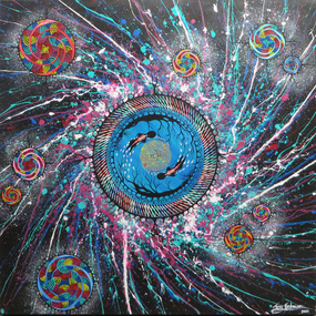 Federation University Art Collection
Painting - Artwork, Troy Firebrace, 'A Galaxy Swirl' by Troy Firebrace, 2015
Troy FIREBRACE (c1994-) Country/Language: Yorta Yorta Troy is a Shepparton born Yorta Yorta man, whose career is on the rise after winning the prestigious Federation University Acquisitive Award for Work by a Victorian Regional Artist at the 10th Victorian Indigenous Art Awards. He completed Year Twelve at Shepparton Secondary College in 2010, and in 2015 Troy was studying Creative Arts at La Trobe University, Bendigo where he has pursued his interest in his Aboriginal identity and art. He is largely influenced by the art of his Uncle Chris Firebrace and he enjoys the design aspects of creating a painting. Usually Troyʼs works contain a narrative, or at least hint of a meaning that he would like to convey to people. Influenced by the imagery of his Aboriginal cultural background he works at bringing together references of landscape, environmental processes and concerns, looking at the way in which we as humans relate to the natural world. Troy seeks to find and demonstrate a connection between humanity and the environment, exploring the idea of harmonious co-existence. Artist's statement: "‘Stories are being told and shared like particles in the universe, a constant swirl of words filled with emotions creating a pattern — explosions — smashing into each other creating a layering effect — creating worlds, planets — well nourished and suited to sustain life, and from this life new stories will emerge, to be told, to be shared — a continuous galaxy swirl. I like the idea that we are a part of something bigger — yes, the earth is massive, but we are just a speck of something far beyond the Milky Way itself.” The work was inspired by the work of abstract expressionist painter Jackson Pollock, science and space. This work won the 2015 Victorian Indigenous Art Awards Federation University Acquisitive Award for work by a Victorian regional artist. His canvas 'A Galaxy Swirl' was described by judges as ‘‘a vibrant and dynamic painting that, as the artist explains, epitomises a bringing together of modernism and Aboriginal arts’’.victorian indigenous art awards, troy firebrace, artwork, artist, indigenous, aboriginal, painting, indigenous artist -
 The Beechworth Burke Museum
Drawing, Ernest Marcuse, Yackandandah V, c1983
Ernest Heinrich Marcuse was born on the 1st of December 1900 to Hedwig and Siegmund Marcuse in Berlin Germany. While Marcuse's artistic talent was apparent from a younger age, his earliest existing artwork was from when he was approximately 20 years old. Ernest's formal art training commenced in 1918 with a three year course at the Berlin school of Interior design. After completion he found work until 1924 when Germany's Great Depression took effect. To broaden his career opportunities he undertook a further 12 months study of fashion, drawing and advertising at Berlin's Reiman school of art. From 1925 to 1934 Ernest was primarily a freelance press artist specialising in industrial, architectural and figurative drawing. Prominent newspaper The Berliner Morgenpost was his largest client along with Gross Deutsche Rundfunaustellung (Germany's organisation for major trade shows). During this period he would create many significant works. Two months after Hitler and the Nazi part came to power in 1933, Ernest received a life changing letter stating that being Jewish he could no longer continue employment in Germany. Up until 1938 he would only be able to undertake private commissions and occasional unofficial work as a book illustrator and games designer. This was by arrangement with non Jewish artists who claimed his work as their own, they would then share the income with Ernest. With increasing unrest in Germany during late 1938 Ernest decided to move to London and there he married his girlfriend Lotte. In late 1939 Ernest and Lotte Marcuse embarked on an eight week journey to their new home in Australia where they had been accepted as refugees. Shortly after arriving in Australia Ernest presented his portfolio to an editor at the Argus newspaper and gained employment as a war events illustrator. He soon became well respected and known in particular for his detailed illustrations and cross sections of ships , artillery and aircrafts. His detailed depictions of battles were displayed on the front pages of The Argus newspaper on a number of occasions. In May 1940 as the war intensified Ernest was dismissed from The Argus newspaper due to his Australian government classification of 'stateless person of enemy origin' and was considered a potential security risk. The editor of the time commented "don't blame us, blame Hitler". Marcuse then began to establish himself as a commercial artist. Ernest was de-classified as a 'stateless person of enemy origin' and in early 1942. The Australian army heard of Ernest's artistic abilities and began to utilize his designs for visual training aids and posters. Ernest became Private E.H Marcuse V377746, his first army posting was as staff artist at The infantry officer's training school at Bonegilla. When off duty he was inspired by the beauty of the surrounding area creating the works in North east Victoria 'Kiewa river bridge', 'Hume weir', ' Dried up river bed' and 'Hawksview gold reef mine' from his 1942-1943 period at Bonegilla Victoria. Ernest returned to the area to create drawings and paintings from 1948 to 1983 in locations including Bright, Wandilligong, Bogong High plains and Wallace's Hut, Mt Buffalo, Beechworth, Pretty valley, Kiewa Hydro, Yackandandah and Bontherambo homestead. These sketches were often completed on location, photographs were also taken onsite to assist the works back at the studio. Occasionally Marcuse also painted in the field. Ernest's preferred choice of medium was pencil and ink. Up until 1952 he would often incorporate watercolour into his work. Later into his career he began introducing pastels, acrylic and mixed media. In earlier years Ernest Marcuse often signed his work Mar, later on the signing of works ranged from Marcuse, E.Marcuse, Ernest Marcuse, EHM or simply EM . If a work was considered incomplete or Marcuse did not like the work it would remain unsigned. From Bonegilla Marcuse was transferred to Woodside South Australia before his final posting in Melbourne until the end of 1945. Ernest's work from within his army posting 'Troop Train at Night' from his 1945 exhibition Australia at War are part of the permanent collection at Canberra's War Museum. Between 1946 and 1969 Ernest largely worked from home and concentrated on a career as a freelance commercial artist and graphic designer. During that time he created work for well known household names including CRA/Conzinc, Vacuum oil (Caltex), Cottee's Brand (Schweppes and Heinz), Home Beautiful magazine Fulton garden supplies, International Iveco trucks, Ego pharmaceuticals, QV and Sunsense. After retirement Ernest concentrated on his true love of fine art and focused on painting images of personal interest both across Australia and Internationally. Earnest never drove a car. He would often walk or use public transport or enlist in the help of family or artist friends to drive him. Throughout his career Ernest Marcuse's artworks were purchase by private collectors these included ACTU, Melbourne City council, Holland Constructions, Melbourne Metropolitan Tramways Board, GJ Coles and Australian Resources Bank. Ernest Marcuse permanent collections can be viewed at The National Gallery of Victoria , Sydney Jewish Museum, Jewish Holocaust Centre Melbourne, Canberra's War Museum, City of Melbourne, Shire of Yarra ranges and now the Burke Museum. © 2020 Art by Marcuse https://www.artbymarcuse.com.au/aboutDonated to the Burke Museum through the Australian Government's Cultural Gifts Program by Peter and Evelyn MarcusePen and pencil landscape drawing on paper.Obverse: Marcuse / YACKANDANDAH / 83 Reverse: YACKANDANDAH / Y 7 / 019 ernest marcuse, marcuse, art, artbymarcuse, beechworth, burke museum, indigo shire, landscape, illustration, drawing, pen and pencil, australian army, war events illustrator, the age, the sun, the argus, germany, refugee, industrial drawing, architectual drawing, figure drawing, berliner morgenpost, grosse deutsche rundfunaustellung, berlin’s reiman school of art., cultural gifts program -
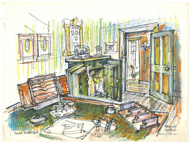
 The Beechworth Burke Museum
Drawing, Ernest Marcuse, Bank of Victoria – Yackandandah II, c1982
Ernest Heinrich Marcuse was born on the 1st of December 1900 to Hedwig and Siegmund Marcuse in Berlin Germany. While Marcuse's artistic talent was apparent from a younger age, his earliest existing artwork was from when he was approximately 20 years old. Ernest's formal art training commenced in 1918 with a three year course at the Berlin school of Interior design. After completion he found work until 1924 when Germany's Great Depression took effect. To broaden his career opportunities he undertook a further 12 months study of fashion, drawing and advertising at Berlin's Reiman school of art. From 1925 to 1934 Ernest was primarily a freelance press artist specialising in industrial, architectural and figurative drawing. Prominent newspaper The Berliner Morgenpost was his largest client along with Gross Deutsche Rundfunaustellung (Germany's organisation for major trade shows). During this period he would create many significant works. Two months after Hitler and the Nazi part came to power in 1933, Ernest received a life changing letter stating that being Jewish he could no longer continue employment in Germany. Up until 1938 he would only be able to undertake private commissions and occasional unofficial work as a book illustrator and games designer. This was by arrangement with non Jewish artists who claimed his work as their own, they would then share the income with Ernest. With increasing unrest in Germany during late 1938 Ernest decided to move to London and there he married his girlfriend Lotte. In late 1939 Ernest and Lotte Marcuse embarked on an eight week journey to their new home in Australia where they had been accepted as refugees. Shortly after arriving in Australia Ernest presented his portfolio to an editor at the Argus newspaper and gained employment as a war events illustrator. He soon became well respected and known in particular for his detailed illustrations and cross sections of ships , artillery and aircrafts. His detailed depictions of battles were displayed on the front pages of The Argus newspaper on a number of occasions. In May 1940 as the war intensified Ernest was dismissed from The Argus newspaper due to his Australian government classification of 'stateless person of enemy origin' and was considered a potential security risk. The editor of the time commented "don't blame us, blame Hitler". Marcuse then began to establish himself as a commercial artist. Ernest was de-classified as a 'stateless person of enemy origin' and in early 1942. The Australian army heard of Ernest's artistic abilities and began to utilize his designs for visual training aids and posters. Ernest became Private E.H Marcuse V377746, his first army posting was as staff artist at The infantry officer's training school at Bonegilla. When off duty he was inspired by the beauty of the surrounding area creating the works in North east Victoria 'Kiewa river bridge', 'Hume weir', ' Dried up river bed' and 'Hawksview gold reef mine' from his 1942-1943 period at Bonegilla Victoria. Ernest returned to the area to create drawings and paintings from 1948 to 1983 in locations including Bright, Wandilligong, Bogong High plains and Wallace's Hut, Mt Buffalo, Beechworth, Pretty valley, Kiewa Hydro, Yackandandah and Bontherambo homestead. These sketches were often completed on location, photographs were also taken onsite to assist the works back at the studio. Occasionally Marcuse also painted in the field. Ernest's preferred choice of medium was pencil and ink. Up until 1952 he would often incorporate watercolour into his work. Later into his career he began introducing pastels, acrylic and mixed media. In earlier years Ernest Marcuse often signed his work Mar, later on the signing of works ranged from Marcuse, E.Marcuse, Ernest Marcuse, EHM or simply EM . If a work was considered incomplete or Marcuse did not like the work it would remain unsigned. From Bonegilla Marcuse was transferred to Woodside South Australia before his final posting in Melbourne until the end of 1945. Ernest's work from within his army posting 'Troop Train at Night' from his 1945 exhibition Australia at War are part of the permanent collection at Canberra's War Museum. Between 1946 and 1969 Ernest largely worked from home and concentrated on a career as a freelance commercial artist and graphic designer. During that time he created work for well known household names including CRA/Conzinc, Vacuum oil (Caltex), Cottee's Brand (Schweppes and Heinz), Home Beautiful magazine Fulton garden supplies, International Iveco trucks, Ego pharmaceuticals, QV and Sunsense. After retirement Ernest concentrated on his true love of fine art and focused on painting images of personal interest both across Australia and Internationally. Earnest never drove a car. He would often walk or use public transport or enlist in the help of family or artist friends to drive him. Throughout his career Ernest Marcuse's artworks were purchase by private collectors these included ACTU, Melbourne City council, Holland Constructions, Melbourne Metropolitan Tramways Board, GJ Coles and Australian Resources Bank. Ernest Marcuse permanent collections can be viewed at The National Gallery of Victoria , Sydney Jewish Museum, Jewish Holocaust Centre Melbourne, Canberra's War Museum, City of Melbourne, Shire of Yarra ranges and now the Burke Museum. © 2020 Art by Marcuse https://www.artbymarcuse.com.au/aboutDonated to the Burke Museum through the Australian Government's Cultural Gifts Program by Peter and Evelyn MarcusePen and pencil landscape drawing on paper.Obverse: BANK OF VICTORIA / YACKANDANDAH / ERNEST MARCUSE / Reverse: Y 4 / 015 ernest marcuse, marcuse, art, artbymarcuse, beechworth, burke museum, indigo shire, landscape, illustration, drawing, pen and pencil, australian army, war events illustrator, the age, the sun, the argus, germany, refugee, industrial drawing, architectual drawing, figure drawing, berliner morgenpost, grosse deutsche rundfunaustellung, berlin’s reiman school of art., cultural gifts program -
 The Beechworth Burke Museum
Drawing, Ernest Marcuse, Yackandandah VII, c1983
Ernest Heinrich Marcuse was born on the 1st of December 1900 to Hedwig and Siegmund Marcuse in Berlin Germany. While Marcuse's artistic talent was apparent from a younger age, his earliest existing artwork was from when he was approximately 20 years old. Ernest's formal art training commenced in 1918 with a three year course at the Berlin school of Interior design. After completion he found work until 1924 when Germany's Great Depression took effect. To broaden his career opportunities he undertook a further 12 months study of fashion, drawing and advertising at Berlin's Reiman school of art. From 1925 to 1934 Ernest was primarily a freelance press artist specialising in industrial, architectural and figurative drawing. Prominent newspaper The Berliner Morgenpost was his largest client along with Gross Deutsche Rundfunaustellung (Germany's organisation for major trade shows). During this period he would create many significant works. Two months after Hitler and the Nazi part came to power in 1933, Ernest received a life changing letter stating that being Jewish he could no longer continue employment in Germany. Up until 1938 he would only be able to undertake private commissions and occasional unofficial work as a book illustrator and games designer. This was by arrangement with non Jewish artists who claimed his work as their own, they would then share the income with Ernest. With increasing unrest in Germany during late 1938 Ernest decided to move to London and there he married his girlfriend Lotte. In late 1939 Ernest and Lotte Marcuse embarked on an eight week journey to their new home in Australia where they had been accepted as refugees. Shortly after arriving in Australia Ernest presented his portfolio to an editor at the Argus newspaper and gained employment as a war events illustrator. He soon became well respected and known in particular for his detailed illustrations and cross sections of ships , artillery and aircrafts. His detailed depictions of battles were displayed on the front pages of The Argus newspaper on a number of occasions. In May 1940 as the war intensified Ernest was dismissed from The Argus newspaper due to his Australian government classification of 'stateless person of enemy origin' and was considered a potential security risk. The editor of the time commented "don't blame us, blame Hitler". Marcuse then began to establish himself as a commercial artist. Ernest was de-classified as a 'stateless person of enemy origin' and in early 1942. The Australian army heard of Ernest's artistic abilities and began to utilize his designs for visual training aids and posters. Ernest became Private E.H Marcuse V377746, his first army posting was as staff artist at The infantry officer's training school at Bonegilla. When off duty he was inspired by the beauty of the surrounding area creating the works in North east Victoria 'Kiewa river bridge', 'Hume weir', ' Dried up river bed' and 'Hawksview gold reef mine' from his 1942-1943 period at Bonegilla Victoria. Ernest returned to the area to create drawings and paintings from 1948 to 1983 in locations including Bright, Wandilligong, Bogong High plains and Wallace's Hut, Mt Buffalo, Beechworth, Pretty valley, Kiewa Hydro, Yackandandah and Bontherambo homestead. These sketches were often completed on location, photographs were also taken onsite to assist the works back at the studio. Occasionally Marcuse also painted in the field. Ernest's preferred choice of medium was pencil and ink. Up until 1952 he would often incorporate watercolour into his work. Later into his career he began introducing pastels, acrylic and mixed media. In earlier years Ernest Marcuse often signed his work Mar, later on the signing of works ranged from Marcuse, E.Marcuse, Ernest Marcuse, EHM or simply EM . If a work was considered incomplete or Marcuse did not like the work it would remain unsigned. From Bonegilla Marcuse was transferred to Woodside South Australia before his final posting in Melbourne until the end of 1945. Ernest's work from within his army posting 'Troop Train at Night' from his 1945 exhibition Australia at War are part of the permanent collection at Canberra's War Museum. Between 1946 and 1969 Ernest largely worked from home and concentrated on a career as a freelance commercial artist and graphic designer. During that time he created work for well known household names including CRA/Conzinc, Vacuum oil (Caltex), Cottee's Brand (Schweppes and Heinz), Home Beautiful magazine Fulton garden supplies, International Iveco trucks, Ego pharmaceuticals, QV and Sunsense. After retirement Ernest concentrated on his true love of fine art and focused on painting images of personal interest both across Australia and Internationally. Earnest never drove a car. He would often walk or use public transport or enlist in the help of family or artist friends to drive him. Throughout his career Ernest Marcuse's artworks were purchase by private collectors these included ACTU, Melbourne City council, Holland Constructions, Melbourne Metropolitan Tramways Board, GJ Coles and Australian Resources Bank. Ernest Marcuse permanent collections can be viewed at The National Gallery of Victoria , Sydney Jewish Museum, Jewish Holocaust Centre Melbourne, Canberra's War Museum, City of Melbourne, Shire of Yarra ranges and now the Burke Museum. © 2020 Art by Marcuse https://www.artbymarcuse.com.au/aboutDonated to the Burke Museum through the Australian Government's Cultural Gifts Program by Peter and Evelyn MarcusePen and pencil landscape drawing on paper.Obverse: ERNEST MARCUSE / YACKANDANDAH / Reverse: Y 10 / 016 ernest marcuse, marcuse, art, artbymarcuse, beechworth, burke museum, indigo shire, landscape, illustration, drawing, pen and pencil, australian army, war events illustrator, the age, the sun, the argus, germany, refugee, industrial drawing, architectual drawing, figure drawing, berliner morgenpost, grosse deutsche rundfunaustellung, berlin’s reiman school of art., cultural gifts program -
 The Beechworth Burke Museum
Drawing, Ernest Marcuse, Yackandandah VI, c1980
Ernest Heinrich Marcuse was born on the 1st of December 1900 to Hedwig and Siegmund Marcuse in Berlin Germany. While Marcuse's artistic talent was apparent from a younger age, his earliest existing artwork was from when he was approximately 20 years old. Ernest's formal art training commenced in 1918 with a three year course at the Berlin school of Interior design. After completion he found work until 1924 when Germany's Great Depression took effect. To broaden his career opportunities he undertook a further 12 months study of fashion, drawing and advertising at Berlin's Reiman school of art. From 1925 to 1934 Ernest was primarily a freelance press artist specialising in industrial, architectural and figurative drawing. Prominent newspaper The Berliner Morgenpost was his largest client along with Gross Deutsche Rundfunaustellung (Germany's organisation for major trade shows). During this period he would create many significant works. Two months after Hitler and the Nazi part came to power in 1933, Ernest received a life changing letter stating that being Jewish he could no longer continue employment in Germany. Up until 1938 he would only be able to undertake private commissions and occasional unofficial work as a book illustrator and games designer. This was by arrangement with non Jewish artists who claimed his work as their own, they would then share the income with Ernest. With increasing unrest in Germany during late 1938 Ernest decided to move to London and there he married his girlfriend Lotte. In late 1939 Ernest and Lotte Marcuse embarked on an eight week journey to their new home in Australia where they had been accepted as refugees. Shortly after arriving in Australia Ernest presented his portfolio to an editor at the Argus newspaper and gained employment as a war events illustrator. He soon became well respected and known in particular for his detailed illustrations and cross sections of ships , artillery and aircrafts. His detailed depictions of battles were displayed on the front pages of The Argus newspaper on a number of occasions. In May 1940 as the war intensified Ernest was dismissed from The Argus newspaper due to his Australian government classification of 'stateless person of enemy origin' and was considered a potential security risk. The editor of the time commented "don't blame us, blame Hitler". Marcuse then began to establish himself as a commercial artist. Ernest was de-classified as a 'stateless person of enemy origin' and in early 1942. The Australian army heard of Ernest's artistic abilities and began to utilize his designs for visual training aids and posters. Ernest became Private E.H Marcuse V377746, his first army posting was as staff artist at The infantry officer's training school at Bonegilla. When off duty he was inspired by the beauty of the surrounding area creating the works in North east Victoria 'Kiewa river bridge', 'Hume weir', ' Dried up river bed' and 'Hawksview gold reef mine' from his 1942-1943 period at Bonegilla Victoria. Ernest returned to the area to create drawings and paintings from 1948 to 1983 in locations including Bright, Wandilligong, Bogong High plains and Wallace's Hut, Mt Buffalo, Beechworth, Pretty valley, Kiewa Hydro, Yackandandah and Bontherambo homestead. These sketches were often completed on location, photographs were also taken onsite to assist the works back at the studio. Occasionally Marcuse also painted in the field. Ernest's preferred choice of medium was pencil and ink. Up until 1952 he would often incorporate watercolour into his work. Later into his career he began introducing pastels, acrylic and mixed media. In earlier years Ernest Marcuse often signed his work Mar, later on the signing of works ranged from Marcuse, E.Marcuse, Ernest Marcuse, EHM or simply EM . If a work was considered incomplete or Marcuse did not like the work it would remain unsigned. From Bonegilla Marcuse was transferred to Woodside South Australia before his final posting in Melbourne until the end of 1945. Ernest's work from within his army posting 'Troop Train at Night' from his 1945 exhibition Australia at War are part of the permanent collection at Canberra's War Museum. Between 1946 and 1969 Ernest largely worked from home and concentrated on a career as a freelance commercial artist and graphic designer. During that time he created work for well known household names including CRA/Conzinc, Vacuum oil (Caltex), Cottee's Brand (Schweppes and Heinz), Home Beautiful magazine Fulton garden supplies, International Iveco trucks, Ego pharmaceuticals, QV and Sunsense. After retirement Ernest concentrated on his true love of fine art and focused on painting images of personal interest both across Australia and Internationally. Earnest never drove a car. He would often walk or use public transport or enlist in the help of family or artist friends to drive him. Throughout his career Ernest Marcuse's artworks were purchase by private collectors these included ACTU, Melbourne City council, Holland Constructions, Melbourne Metropolitan Tramways Board, GJ Coles and Australian Resources Bank. Ernest Marcuse permanent collections can be viewed at The National Gallery of Victoria , Sydney Jewish Museum, Jewish Holocaust Centre Melbourne, Canberra's War Museum, City of Melbourne, Shire of Yarra ranges and now the Burke Museum. © 2020 Art by Marcuse https://www.artbymarcuse.com.au/aboutDonated to the Burke Museum through the Australian Government's Cultural Gifts Program by Peter and Evelyn MarcusePen and pencil landscape drawing on paper.Obverse: YACKANDANDAH / 80 Reverse: Y 5 / 018 ernest marcuse, marcuse, art, artbymarcuse, beechworth, burke museum, indigo shire, landscape, illustration, drawing, pen and pencil, australian army, war events illustrator, the age, the sun, the argus, germany, refugee, industrial drawing, architectual drawing, figure drawing, berliner morgenpost, grosse deutsche rundfunaustellung, berlin’s reiman school of art., cultural gifts program -
 The Beechworth Burke Museum
Drawing, Ernest Marcuse, Bank of Victoria – Yackandandah I, c1983
Ernest Heinrich Marcuse was born on the 1st of December 1900 to Hedwig and Siegmund Marcuse in Berlin Germany. While Marcuse's artistic talent was apparent from a younger age, his earliest existing artwork was from when he was approximately 20 years old. Ernest's formal art training commenced in 1918 with a three year course at the Berlin school of Interior design. After completion he found work until 1924 when Germany's Great Depression took effect. To broaden his career opportunities he undertook a further 12 months study of fashion, drawing and advertising at Berlin's Reiman school of art. From 1925 to 1934 Ernest was primarily a freelance press artist specialising in industrial, architectural and figurative drawing. Prominent newspaper The Berliner Morgenpost was his largest client along with Gross Deutsche Rundfunaustellung (Germany's organisation for major trade shows). During this period he would create many significant works. Two months after Hitler and the Nazi part came to power in 1933, Ernest received a life changing letter stating that being Jewish he could no longer continue employment in Germany. Up until 1938 he would only be able to undertake private commissions and occasional unofficial work as a book illustrator and games designer. This was by arrangement with non Jewish artists who claimed his work as their own, they would then share the income with Ernest. With increasing unrest in Germany during late 1938 Ernest decided to move to London and there he married his girlfriend Lotte. In late 1939 Ernest and Lotte Marcuse embarked on an eight week journey to their new home in Australia where they had been accepted as refugees. Shortly after arriving in Australia Ernest presented his portfolio to an editor at the Argus newspaper and gained employment as a war events illustrator. He soon became well respected and known in particular for his detailed illustrations and cross sections of ships , artillery and aircrafts. His detailed depictions of battles were displayed on the front pages of The Argus newspaper on a number of occasions. In May 1940 as the war intensified Ernest was dismissed from The Argus newspaper due to his Australian government classification of 'stateless person of enemy origin' and was considered a potential security risk. The editor of the time commented "don't blame us, blame Hitler". Marcuse then began to establish himself as a commercial artist. Ernest was de-classified as a 'stateless person of enemy origin' and in early 1942. The Australian army heard of Ernest's artistic abilities and began to utilize his designs for visual training aids and posters. Ernest became Private E.H Marcuse V377746, his first army posting was as staff artist at The infantry officer's training school at Bonegilla. When off duty he was inspired by the beauty of the surrounding area creating the works in North east Victoria 'Kiewa river bridge', 'Hume weir', ' Dried up river bed' and 'Hawksview gold reef mine' from his 1942-1943 period at Bonegilla Victoria. Ernest returned to the area to create drawings and paintings from 1948 to 1983 in locations including Bright, Wandilligong, Bogong High plains and Wallace's Hut, Mt Buffalo, Beechworth, Pretty valley, Kiewa Hydro, Yackandandah and Bontherambo homestead. These sketches were often completed on location, photographs were also taken onsite to assist the works back at the studio. Occasionally Marcuse also painted in the field. Ernest's preferred choice of medium was pencil and ink. Up until 1952 he would often incorporate watercolour into his work. Later into his career he began introducing pastels, acrylic and mixed media. In earlier years Ernest Marcuse often signed his work Mar, later on the signing of works ranged from Marcuse, E.Marcuse, Ernest Marcuse, EHM or simply EM . If a work was considered incomplete or Marcuse did not like the work it would remain unsigned. From Bonegilla Marcuse was transferred to Woodside South Australia before his final posting in Melbourne until the end of 1945. Ernest's work from within his army posting 'Troop Train at Night' from his 1945 exhibition Australia at War are part of the permanent collection at Canberra's War Museum. Between 1946 and 1969 Ernest largely worked from home and concentrated on a career as a freelance commercial artist and graphic designer. During that time he created work for well known household names including CRA/Conzinc, Vacuum oil (Caltex), Cottee's Brand (Schweppes and Heinz), Home Beautiful magazine Fulton garden supplies, International Iveco trucks, Ego pharmaceuticals, QV and Sunsense. After retirement Ernest concentrated on his true love of fine art and focused on painting images of personal interest both across Australia and Internationally. Earnest never drove a car. He would often walk or use public transport or enlist in the help of family or artist friends to drive him. Throughout his career Ernest Marcuse's artworks were purchase by private collectors these included ACTU, Melbourne City council, Holland Constructions, Melbourne Metropolitan Tramways Board, GJ Coles and Australian Resources Bank. Ernest Marcuse permanent collections can be viewed at The National Gallery of Victoria , Sydney Jewish Museum, Jewish Holocaust Centre Melbourne, Canberra's War Museum, City of Melbourne, Shire of Yarra ranges and now the Burke Museum. © 2020 Art by Marcuse https://www.artbymarcuse.com.au/aboutDonated to the Burke Museum through the Australian Government's Cultural Gifts Program by Peter and Evelyn MarcusePen and pencil landscape drawing on paper.Obverse: BANK OF VICTORIA / YACKANDANDAH / Reverse: Y 6 / 017 ernest marcuse, marcuse, art, artbymarcuse, beechworth, burke museum, indigo shire, landscape, illustration, drawing, pen and pencil, australian army, war events illustrator, the age, the sun, the argus, germany, refugee, industrial drawing, architectual drawing, figure drawing, berliner morgenpost, grosse deutsche rundfunaustellung, berlin’s reiman school of art., cultural gifts program -
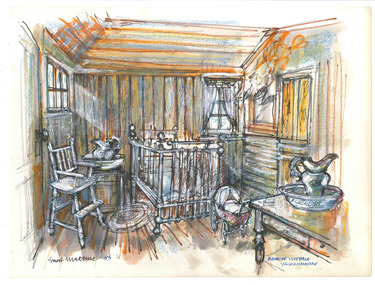 The Beechworth Burke Museum
Drawing, Ernest Marcuse, Bank of Victoria – Yackandandah III, c1983
Ernest Heinrich Marcuse was born on the 1st of December 1900 to Hedwig and Siegmund Marcuse in Berlin Germany. While Marcuse's artistic talent was apparent from a younger age, his earliest existing artwork was from when he was approximately 20 years old. Ernest's formal art training commenced in 1918 with a three year course at the Berlin school of Interior design. After completion he found work until 1924 when Germany's Great Depression took effect. To broaden his career opportunities he undertook a further 12 months study of fashion, drawing and advertising at Berlin's Reiman school of art. From 1925 to 1934 Ernest was primarily a freelance press artist specialising in industrial, architectural and figurative drawing. Prominent newspaper The Berliner Morgenpost was his largest client along with Gross Deutsche Rundfunaustellung (Germany's organisation for major trade shows). During this period he would create many significant works. Two months after Hitler and the Nazi part came to power in 1933, Ernest received a life changing letter stating that being Jewish he could no longer continue employment in Germany. Up until 1938 he would only be able to undertake private commissions and occasional unofficial work as a book illustrator and games designer. This was by arrangement with non Jewish artists who claimed his work as their own, they would then share the income with Ernest. With increasing unrest in Germany during late 1938 Ernest decided to move to London and there he married his girlfriend Lotte. In late 1939 Ernest and Lotte Marcuse embarked on an eight week journey to their new home in Australia where they had been accepted as refugees. Shortly after arriving in Australia Ernest presented his portfolio to an editor at the Argus newspaper and gained employment as a war events illustrator. He soon became well respected and known in particular for his detailed illustrations and cross sections of ships , artillery and aircrafts. His detailed depictions of battles were displayed on the front pages of The Argus newspaper on a number of occasions. In May 1940 as the war intensified Ernest was dismissed from The Argus newspaper due to his Australian government classification of 'stateless person of enemy origin' and was considered a potential security risk. The editor of the time commented "don't blame us, blame Hitler". Marcuse then began to establish himself as a commercial artist. Ernest was de-classified as a 'stateless person of enemy origin' and in early 1942. The Australian army heard of Ernest's artistic abilities and began to utilize his designs for visual training aids and posters. Ernest became Private E.H Marcuse V377746, his first army posting was as staff artist at The infantry officer's training school at Bonegilla. When off duty he was inspired by the beauty of the surrounding area creating the works in North east Victoria 'Kiewa river bridge', 'Hume weir', ' Dried up river bed' and 'Hawksview gold reef mine' from his 1942-1943 period at Bonegilla Victoria. Ernest returned to the area to create drawings and paintings from 1948 to 1983 in locations including Bright, Wandilligong, Bogong High plains and Wallace's Hut, Mt Buffalo, Beechworth, Pretty valley, Kiewa Hydro, Yackandandah and Bontherambo homestead. These sketches were often completed on location, photographs were also taken onsite to assist the works back at the studio. Occasionally Marcuse also painted in the field. Ernest's preferred choice of medium was pencil and ink. Up until 1952 he would often incorporate watercolour into his work. Later into his career he began introducing pastels, acrylic and mixed media. In earlier years Ernest Marcuse often signed his work Mar, later on the signing of works ranged from Marcuse, E.Marcuse, Ernest Marcuse, EHM or simply EM . If a work was considered incomplete or Marcuse did not like the work it would remain unsigned. From Bonegilla Marcuse was transferred to Woodside South Australia before his final posting in Melbourne until the end of 1945. Ernest's work from within his army posting 'Troop Train at Night' from his 1945 exhibition Australia at War are part of the permanent collection at Canberra's War Museum. Between 1946 and 1969 Ernest largely worked from home and concentrated on a career as a freelance commercial artist and graphic designer. During that time he created work for well known household names including CRA/Conzinc, Vacuum oil (Caltex), Cottee's Brand (Schweppes and Heinz), Home Beautiful magazine Fulton garden supplies, International Iveco trucks, Ego pharmaceuticals, QV and Sunsense. After retirement Ernest concentrated on his true love of fine art and focused on painting images of personal interest both across Australia and Internationally. Earnest never drove a car. He would often walk or use public transport or enlist in the help of family or artist friends to drive him. Throughout his career Ernest Marcuse's artworks were purchase by private collectors these included ACTU, Melbourne City council, Holland Constructions, Melbourne Metropolitan Tramways Board, GJ Coles and Australian Resources Bank. Ernest Marcuse permanent collections can be viewed at The National Gallery of Victoria , Sydney Jewish Museum, Jewish Holocaust Centre Melbourne, Canberra's War Museum, City of Melbourne, Shire of Yarra ranges and now the Burke Museum. © 2020 Art by Marcuse https://www.artbymarcuse.com.au/aboutDonated to the Burke Museum through the Australian Government's Cultural Gifts Program by Peter and Evelyn MarcusePen and pencil landscape drawing on paper.Obverse: ERNEST MARCUSE / BANK OF VICTORIA / YACKANDANDAH Reverse: Y 2 / 013 ernest marcuse, marcuse, art, artbymarcuse, beechworth, burke museum, indigo shire, landscape, illustration, drawing, pen and pencil, australian army, war events illustrator, the age, the sun, the argus, germany, refugee, industrial drawing, architectual drawing, figure drawing, berliner morgenpost, grosse deutsche rundfunaustellung, berlin’s reiman school of art., cultural gifts program -
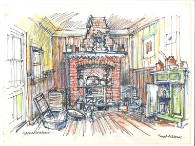 The Beechworth Burke Museum
Drawing, Ernest Marcuse, Yackandandah XI, c1972-1976
Ernest Heinrich Marcuse was born on the 1st of December 1900 to Hedwig and Siegmund Marcuse in Berlin Germany. While Marcuse's artistic talent was apparent from a younger age, his earliest existing artwork was from when he was approximately 20 years old. Ernest's formal art training commenced in 1918 with a three year course at the Berlin school of Interior design. After completion he found work until 1924 when Germany's Great Depression took effect. To broaden his career opportunities he undertook a further 12 months study of fashion, drawing and advertising at Berlin's Reiman school of art. From 1925 to 1934 Ernest was primarily a freelance press artist specialising in industrial, architectural and figurative drawing. Prominent newspaper The Berliner Morgenpost was his largest client along with Gross Deutsche Rundfunaustellung (Germany's organisation for major trade shows). During this period he would create many significant works. Two months after Hitler and the Nazi part came to power in 1933, Ernest received a life changing letter stating that being Jewish he could no longer continue employment in Germany. Up until 1938 he would only be able to undertake private commissions and occasional unofficial work as a book illustrator and games designer. This was by arrangement with non Jewish artists who claimed his work as their own, they would then share the income with Ernest. With increasing unrest in Germany during late 1938 Ernest decided to move to London and there he married his girlfriend Lotte. In late 1939 Ernest and Lotte Marcuse embarked on an eight week journey to their new home in Australia where they had been accepted as refugees. Shortly after arriving in Australia Ernest presented his portfolio to an editor at the Argus newspaper and gained employment as a war events illustrator. He soon became well respected and known in particular for his detailed illustrations and cross sections of ships , artillery and aircrafts. His detailed depictions of battles were displayed on the front pages of The Argus newspaper on a number of occasions. In May 1940 as the war intensified Ernest was dismissed from The Argus newspaper due to his Australian government classification of 'stateless person of enemy origin' and was considered a potential security risk. The editor of the time commented "don't blame us, blame Hitler". Marcuse then began to establish himself as a commercial artist. Ernest was de-classified as a 'stateless person of enemy origin' and in early 1942. The Australian army heard of Ernest's artistic abilities and began to utilize his designs for visual training aids and posters. Ernest became Private E.H Marcuse V377746, his first army posting was as staff artist at The infantry officer's training school at Bonegilla. When off duty he was inspired by the beauty of the surrounding area creating the works in North east Victoria 'Kiewa river bridge', 'Hume weir', ' Dried up river bed' and 'Hawksview gold reef mine' from his 1942-1943 period at Bonegilla Victoria. Ernest returned to the area to create drawings and paintings from 1948 to 1983 in locations including Bright, Wandilligong, Bogong High plains and Wallace's Hut, Mt Buffalo, Beechworth, Pretty valley, Kiewa Hydro, Yackandandah and Bontherambo homestead. These sketches were often completed on location, photographs were also taken onsite to assist the works back at the studio. Occasionally Marcuse also painted in the field. Ernest's preferred choice of medium was pencil and ink. Up until 1952 he would often incorporate watercolour into his work. Later into his career he began introducing pastels, acrylic and mixed media. In earlier years Ernest Marcuse often signed his work Mar, later on the signing of works ranged from Marcuse, E.Marcuse, Ernest Marcuse, EHM or simply EM . If a work was considered incomplete or Marcuse did not like the work it would remain unsigned. From Bonegilla Marcuse was transferred to Woodside South Australia before his final posting in Melbourne until the end of 1945. Ernest's work from within his army posting 'Troop Train at Night' from his 1945 exhibition Australia at War are part of the permanent collection at Canberra's War Museum. Between 1946 and 1969 Ernest largely worked from home and concentrated on a career as a freelance commercial artist and graphic designer. During that time he created work for well known household names including CRA/Conzinc, Vacuum oil (Caltex), Cottee's Brand (Schweppes and Heinz), Home Beautiful magazine Fulton garden supplies, International Iveco trucks, Ego pharmaceuticals, QV and Sunsense. After retirement Ernest concentrated on his true love of fine art and focused on painting images of personal interest both across Australia and Internationally. Earnest never drove a car. He would often walk or use public transport or enlist in the help of family or artist friends to drive him. Throughout his career Ernest Marcuse's artworks were purchase by private collectors these included ACTU, Melbourne City council, Holland Constructions, Melbourne Metropolitan Tramways Board, GJ Coles and Australian Resources Bank. Ernest Marcuse permanent collections can be viewed at The National Gallery of Victoria , Sydney Jewish Museum, Jewish Holocaust Centre Melbourne, Canberra's War Museum, City of Melbourne, Shire of Yarra ranges and now the Burke Museum. © 2020 Art by Marcuse https://www.artbymarcuse.com.au/aboutDonated to the Burke Museum through the Australian Government's Cultural Gifts Program by Peter and Evelyn MarcusePen and pencil landscape drawing on paper.Obverse: YACKANDANDAH / ERNEST MARCUSE Reverse: Y 1 / 012 ernest marcuse, marcuse, art, artbymarcuse, beechworth, burke museum, indigo shire, landscape, illustration, drawing, pen and pencil, australian army, war events illustrator, the age, the sun, the argus, germany, refugee, industrial drawing, architectual drawing, figure drawing, berliner morgenpost, grosse deutsche rundfunaustellung, berlin’s reiman school of art., cultural gifts program -
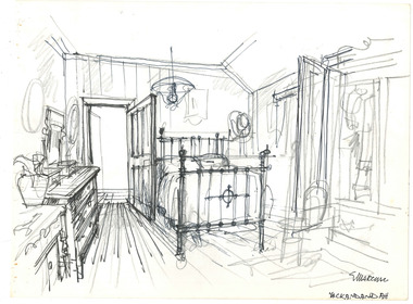 The Beechworth Burke Museum
Drawing, Ernest Marcuse, Yackandandah VIII, c1983
Ernest Heinrich Marcuse was born on the 1st of December 1900 to Hedwig and Siegmund Marcuse in Berlin Germany. While Marcuse's artistic talent was apparent from a younger age, his earliest existing artwork was from when he was approximately 20 years old. Ernest's formal art training commenced in 1918 with a three year course at the Berlin school of Interior design. After completion he found work until 1924 when Germany's Great Depression took effect. To broaden his career opportunities he undertook a further 12 months study of fashion, drawing and advertising at Berlin's Reiman school of art. From 1925 to 1934 Ernest was primarily a freelance press artist specialising in industrial, architectural and figurative drawing. Prominent newspaper The Berliner Morgenpost was his largest client along with Gross Deutsche Rundfunaustellung (Germany's organisation for major trade shows). During this period he would create many significant works. Two months after Hitler and the Nazi part came to power in 1933, Ernest received a life changing letter stating that being Jewish he could no longer continue employment in Germany. Up until 1938 he would only be able to undertake private commissions and occasional unofficial work as a book illustrator and games designer. This was by arrangement with non Jewish artists who claimed his work as their own, they would then share the income with Ernest. With increasing unrest in Germany during late 1938 Ernest decided to move to London and there he married his girlfriend Lotte. In late 1939 Ernest and Lotte Marcuse embarked on an eight week journey to their new home in Australia where they had been accepted as refugees. Shortly after arriving in Australia Ernest presented his portfolio to an editor at the Argus newspaper and gained employment as a war events illustrator. He soon became well respected and known in particular for his detailed illustrations and cross sections of ships , artillery and aircrafts. His detailed depictions of battles were displayed on the front pages of The Argus newspaper on a number of occasions. In May 1940 as the war intensified Ernest was dismissed from The Argus newspaper due to his Australian government classification of 'stateless person of enemy origin' and was considered a potential security risk. The editor of the time commented "don't blame us, blame Hitler". Marcuse then began to establish himself as a commercial artist. Ernest was de-classified as a 'stateless person of enemy origin' and in early 1942. The Australian army heard of Ernest's artistic abilities and began to utilize his designs for visual training aids and posters. Ernest became Private E.H Marcuse V377746, his first army posting was as staff artist at The infantry officer's training school at Bonegilla. When off duty he was inspired by the beauty of the surrounding area creating the works in North east Victoria 'Kiewa river bridge', 'Hume weir', ' Dried up river bed' and 'Hawksview gold reef mine' from his 1942-1943 period at Bonegilla Victoria. Ernest returned to the area to create drawings and paintings from 1948 to 1983 in locations including Bright, Wandilligong, Bogong High plains and Wallace's Hut, Mt Buffalo, Beechworth, Pretty valley, Kiewa Hydro, Yackandandah and Bontherambo homestead. These sketches were often completed on location, photographs were also taken onsite to assist the works back at the studio. Occasionally Marcuse also painted in the field. Ernest's preferred choice of medium was pencil and ink. Up until 1952 he would often incorporate watercolour into his work. Later into his career he began introducing pastels, acrylic and mixed media. In earlier years Ernest Marcuse often signed his work Mar, later on the signing of works ranged from Marcuse, E.Marcuse, Ernest Marcuse, EHM or simply EM . If a work was considered incomplete or Marcuse did not like the work it would remain unsigned. From Bonegilla Marcuse was transferred to Woodside South Australia before his final posting in Melbourne until the end of 1945. Ernest's work from within his army posting 'Troop Train at Night' from his 1945 exhibition Australia at War are part of the permanent collection at Canberra's War Museum. Between 1946 and 1969 Ernest largely worked from home and concentrated on a career as a freelance commercial artist and graphic designer. During that time he created work for well known household names including CRA/Conzinc, Vacuum oil (Caltex), Cottee's Brand (Schweppes and Heinz), Home Beautiful magazine Fulton garden supplies, International Iveco trucks, Ego pharmaceuticals, QV and Sunsense. After retirement Ernest concentrated on his true love of fine art and focused on painting images of personal interest both across Australia and Internationally. Earnest never drove a car. He would often walk or use public transport or enlist in the help of family or artist friends to drive him. Throughout his career Ernest Marcuse's artworks were purchase by private collectors these included ACTU, Melbourne City council, Holland Constructions, Melbourne Metropolitan Tramways Board, GJ Coles and Australian Resources Bank. Ernest Marcuse permanent collections can be viewed at The National Gallery of Victoria , Sydney Jewish Museum, Jewish Holocaust Centre Melbourne, Canberra's War Museum, City of Melbourne, Shire of Yarra ranges and now the Burke Museum. © 2020 Art by Marcuse https://www.artbymarcuse.com.au/aboutDonated to the Burke Museum through the Australian Government's Cultural Gifts Program by Peter and Evelyn MarcusePen and pencil landscape drawing on paper.Obverse: MARCUSE / YACKANDANDAH / Reverse: Y 3 / 014 / ernest marcuse, marcuse, art, artbymarcuse, beechworth, burke museum, indigo shire, landscape, illustration, drawing, pen and pencil, australian army, war events illustrator, the age, the sun, the argus, germany, refugee, industrial drawing, architectual drawing, figure drawing, berliner morgenpost, grosse deutsche rundfunaustellung, berlin’s reiman school of art., cultural gifts program -
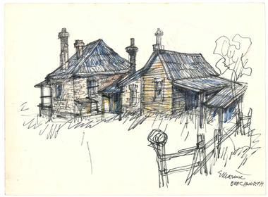 The Beechworth Burke Museum
Drawing, Ernest Marcuse, Beechworth II, c1972-1976
Ernest Heinrich Marcuse was born on the 1st of December 1900 to Hedwig and Siegmund Marcuse in Berlin Germany. While Marcuse's artistic talent was apparent from a younger age, his earliest existing artwork was from when he was approximately 20 years old. Ernest's formal art training commenced in 1918 with a three year course at the Berlin school of Interior design. After completion he found work until 1924 when Germany's Great Depression took effect. To broaden his career opportunities he undertook a further 12 months study of fashion, drawing and advertising at Berlin's Reiman school of art. From 1925 to 1934 Ernest was primarily a freelance press artist specialising in industrial, architectural and figurative drawing. Prominent newspaper The Berliner Morgenpost was his largest client along with Gross Deutsche Rundfunaustellung (Germany's organisation for major trade shows). During this period he would create many significant works. Two months after Hitler and the Nazi part came to power in 1933, Ernest received a life changing letter stating that being Jewish he could no longer continue employment in Germany. Up until 1938 he would only be able to undertake private commissions and occasional unofficial work as a book illustrator and games designer. This was by arrangement with non Jewish artists who claimed his work as their own, they would then share the income with Ernest. With increasing unrest in Germany during late 1938 Ernest decided to move to London and there he married his girlfriend Lotte. In late 1939 Ernest and Lotte Marcuse embarked on an eight week journey to their new home in Australia where they had been accepted as refugees. Shortly after arriving in Australia Ernest presented his portfolio to an editor at the Argus newspaper and gained employment as a war events illustrator. He soon became well respected and known in particular for his detailed illustrations and cross sections of ships , artillery and aircrafts. His detailed depictions of battles were displayed on the front pages of The Argus newspaper on a number of occasions. In May 1940 as the war intensified Ernest was dismissed from The Argus newspaper due to his Australian government classification of 'stateless person of enemy origin' and was considered a potential security risk. The editor of the time commented "don't blame us, blame Hitler". Marcuse then began to establish himself as a commercial artist. Ernest was de-classified as a 'stateless person of enemy origin' and in early 1942. The Australian army heard of Ernest's artistic abilities and began to utilize his designs for visual training aids and posters. Ernest became Private E.H Marcuse V377746, his first army posting was as staff artist at The infantry officer's training school at Bonegilla. When off duty he was inspired by the beauty of the surrounding area creating the works in North east Victoria 'Kiewa river bridge', 'Hume weir', ' Dried up river bed' and 'Hawksview gold reef mine' from his 1942-1943 period at Bonegilla Victoria. Ernest returned to the area to create drawings and paintings from 1948 to 1983 in locations including Bright, Wandilligong, Bogong High plains and Wallace's Hut, Mt Buffalo, Beechworth, Pretty valley, Kiewa Hydro, Yackandandah and Bontherambo homestead. These sketches were often completed on location, photographs were also taken onsite to assist the works back at the studio. Occasionally Marcuse also painted in the field. Ernest's preferred choice of medium was pencil and ink. Up until 1952 he would often incorporate watercolour into his work. Later into his career he began introducing pastels, acrylic and mixed media. In earlier years Ernest Marcuse often signed his work Mar, later on the signing of works ranged from Marcuse, E.Marcuse, Ernest Marcuse, EHM or simply EM . If a work was considered incomplete or Marcuse did not like the work it would remain unsigned. From Bonegilla Marcuse was transferred to Woodside South Australia before his final posting in Melbourne until the end of 1945. Ernest's work from within his army posting 'Troop Train at Night' from his 1945 exhibition Australia at War are part of the permanent collection at Canberra's War Museum. Between 1946 and 1969 Ernest largely worked from home and concentrated on a career as a freelance commercial artist and graphic designer. During that time he created work for well known household names including CRA/Conzinc, Vacuum oil (Caltex), Cottee's Brand (Schweppes and Heinz), Home Beautiful magazine Fulton garden supplies, International Iveco trucks, Ego pharmaceuticals, QV and Sunsense. After retirement Ernest concentrated on his true love of fine art and focused on painting images of personal interest both across Australia and Internationally. Earnest never drove a car. He would often walk or use public transport or enlist in the help of family or artist friends to drive him. Throughout his career Ernest Marcuse's artworks were purchase by private collectors these included ACTU, Melbourne City council, Holland Constructions, Melbourne Metropolitan Tramways Board, GJ Coles and Australian Resources Bank. Ernest Marcuse permanent collections can be viewed at The National Gallery of Victoria , Sydney Jewish Museum, Jewish Holocaust Centre Melbourne, Canberra's War Museum, City of Melbourne, Shire of Yarra ranges and now the Burke Museum. © 2020 Art by Marcuse https://www.artbymarcuse.com.au/aboutDonated to the Burke Museum through the Australian Government's Cultural Gifts Program by Peter and Evelyn MarcusePen and pencil landscape drawing on paper.Obverse: (illegible) / BEECHWORTH Reverse: BEECHWORTH / MARCUSE BEECHWORTH NOSTALGIA BW-06 / B10 ernest marcuse, marcuse, art, artbymarcuse, beechworth, burke museum, indigo shire, landscape, illustration, drawing, pen and pencil, australian army, war events illustrator, the age, the sun, the argus, germany, refugee, industrial drawing, architectual drawing, figure drawing, berliner morgenpost, grosse deutsche rundfunaustellung, berlin’s reiman school of art., cultural gifts program -
 The Beechworth Burke Museum
Drawing, Ernest Marcuse, Beechworth Carriage Museum II, c1972-1976
Ernest Heinrich Marcuse was born on the 1st of December 1900 to Hedwig and Siegmund Marcuse in Berlin Germany. While Marcuse's artistic talent was apparent from a younger age, his earliest existing artwork was from when he was approximately 20 years old. Ernest's formal art training commenced in 1918 with a three year course at the Berlin school of Interior design. After completion he found work until 1924 when Germany's Great Depression took effect. To broaden his career opportunities he undertook a further 12 months study of fashion, drawing and advertising at Berlin's Reiman school of art. From 1925 to 1934 Ernest was primarily a freelance press artist specialising in industrial, architectural and figurative drawing. Prominent newspaper The Berliner Morgenpost was his largest client along with Gross Deutsche Rundfunaustellung (Germany's organisation for major trade shows). During this period he would create many significant works. Two months after Hitler and the Nazi part came to power in 1933, Ernest received a life changing letter stating that being Jewish he could no longer continue employment in Germany. Up until 1938 he would only be able to undertake private commissions and occasional unofficial work as a book illustrator and games designer. This was by arrangement with non Jewish artists who claimed his work as their own, they would then share the income with Ernest. With increasing unrest in Germany during late 1938 Ernest decided to move to London and there he married his girlfriend Lotte. In late 1939 Ernest and Lotte Marcuse embarked on an eight week journey to their new home in Australia where they had been accepted as refugees. Shortly after arriving in Australia Ernest presented his portfolio to an editor at the Argus newspaper and gained employment as a war events illustrator. He soon became well respected and known in particular for his detailed illustrations and cross sections of ships , artillery and aircrafts. His detailed depictions of battles were displayed on the front pages of The Argus newspaper on a number of occasions. In May 1940 as the war intensified Ernest was dismissed from The Argus newspaper due to his Australian government classification of 'stateless person of enemy origin' and was considered a potential security risk. The editor of the time commented "don't blame us, blame Hitler". Marcuse then began to establish himself as a commercial artist. Ernest was de-classified as a 'stateless person of enemy origin' and in early 1942. The Australian army heard of Ernest's artistic abilities and began to utilize his designs for visual training aids and posters. Ernest became Private E.H Marcuse V377746, his first army posting was as staff artist at The infantry officer's training school at Bonegilla. When off duty he was inspired by the beauty of the surrounding area creating the works in North east Victoria 'Kiewa river bridge', 'Hume weir', ' Dried up river bed' and 'Hawksview gold reef mine' from his 1942-1943 period at Bonegilla Victoria. Ernest returned to the area to create drawings and paintings from 1948 to 1983 in locations including Bright, Wandilligong, Bogong High plains and Wallace's Hut, Mt Buffalo, Beechworth, Pretty valley, Kiewa Hydro, Yackandandah and Bontherambo homestead. These sketches were often completed on location, photographs were also taken onsite to assist the works back at the studio. Occasionally Marcuse also painted in the field. Ernest's preferred choice of medium was pencil and ink. Up until 1952 he would often incorporate watercolour into his work. Later into his career he began introducing pastels, acrylic and mixed media. In earlier years Ernest Marcuse often signed his work Mar, later on the signing of works ranged from Marcuse, E.Marcuse, Ernest Marcuse, EHM or simply EM . If a work was considered incomplete or Marcuse did not like the work it would remain unsigned. From Bonegilla Marcuse was transferred to Woodside South Australia before his final posting in Melbourne until the end of 1945. Ernest's work from within his army posting 'Troop Train at Night' from his 1945 exhibition Australia at War are part of the permanent collection at Canberra's War Museum. Between 1946 and 1969 Ernest largely worked from home and concentrated on a career as a freelance commercial artist and graphic designer. During that time he created work for well known household names including CRA/Conzinc, Vacuum oil (Caltex), Cottee's Brand (Schweppes and Heinz), Home Beautiful magazine Fulton garden supplies, International Iveco trucks, Ego pharmaceuticals, QV and Sunsense. After retirement Ernest concentrated on his true love of fine art and focused on painting images of personal interest both across Australia and Internationally. Earnest never drove a car. He would often walk or use public transport or enlist in the help of family or artist friends to drive him. Throughout his career Ernest Marcuse's artworks were purchase by private collectors these included ACTU, Melbourne City council, Holland Constructions, Melbourne Metropolitan Tramways Board, GJ Coles and Australian Resources Bank. Ernest Marcuse permanent collections can be viewed at The National Gallery of Victoria , Sydney Jewish Museum, Jewish Holocaust Centre Melbourne, Canberra's War Museum, City of Melbourne, Shire of Yarra ranges and now the Burke Museum. © 2020 Art by Marcuse https://www.artbymarcuse.com.au/aboutDonated to the Burke Museum through the Australian Government's Cultural Gifts Program by Peter and Evelyn MarcusePen and pencil landscape drawing on paper.Obverse: Charatome / Corning Buggy / Braise & Drag / believed to (illegible) built by Crawford and (illegible) / COBB & CO / WAGONETTE / B'WORTH MUSEUM Reverse: BEECHWORTH NOSTALGIA / BW-07(a) / B 8 / ernest marcuse, marcuse, art, artbymarcuse, beechworth, burke museum, indigo shire, landscape, illustration, drawing, pen and pencil, australian army, war events illustrator, the age, the sun, the argus, germany, refugee, industrial drawing, architectual drawing, figure drawing, berliner morgenpost, grosse deutsche rundfunaustellung, berlin’s reiman school of art., cultural gifts program -
 The Beechworth Burke Museum
Drawing, Ernest Marcuse, Beechworth Carriage Museum III, c1972-1976
Ernest Heinrich Marcuse was born on the 1st of December 1900 to Hedwig and Siegmund Marcuse in Berlin Germany. While Marcuse's artistic talent was apparent from a younger age, his earliest existing artwork was from when he was approximately 20 years old. Ernest's formal art training commenced in 1918 with a three year course at the Berlin school of Interior design. After completion he found work until 1924 when Germany's Great Depression took effect. To broaden his career opportunities he undertook a further 12 months study of fashion, drawing and advertising at Berlin's Reiman school of art. From 1925 to 1934 Ernest was primarily a freelance press artist specialising in industrial, architectural and figurative drawing. Prominent newspaper The Berliner Morgenpost was his largest client along with Gross Deutsche Rundfunaustellung (Germany's organisation for major trade shows). During this period he would create many significant works. Two months after Hitler and the Nazi part came to power in 1933, Ernest received a life changing letter stating that being Jewish he could no longer continue employment in Germany. Up until 1938 he would only be able to undertake private commissions and occasional unofficial work as a book illustrator and games designer. This was by arrangement with non Jewish artists who claimed his work as their own, they would then share the income with Ernest. With increasing unrest in Germany during late 1938 Ernest decided to move to London and there he married his girlfriend Lotte. In late 1939 Ernest and Lotte Marcuse embarked on an eight week journey to their new home in Australia where they had been accepted as refugees. Shortly after arriving in Australia Ernest presented his portfolio to an editor at the Argus newspaper and gained employment as a war events illustrator. He soon became well respected and known in particular for his detailed illustrations and cross sections of ships , artillery and aircrafts. His detailed depictions of battles were displayed on the front pages of The Argus newspaper on a number of occasions. In May 1940 as the war intensified Ernest was dismissed from The Argus newspaper due to his Australian government classification of 'stateless person of enemy origin' and was considered a potential security risk. The editor of the time commented "don't blame us, blame Hitler". Marcuse then began to establish himself as a commercial artist. Ernest was de-classified as a 'stateless person of enemy origin' and in early 1942. The Australian army heard of Ernest's artistic abilities and began to utilize his designs for visual training aids and posters. Ernest became Private E.H Marcuse V377746, his first army posting was as staff artist at The infantry officer's training school at Bonegilla. When off duty he was inspired by the beauty of the surrounding area creating the works in North east Victoria 'Kiewa river bridge', 'Hume weir', ' Dried up river bed' and 'Hawksview gold reef mine' from his 1942-1943 period at Bonegilla Victoria. Ernest returned to the area to create drawings and paintings from 1948 to 1983 in locations including Bright, Wandilligong, Bogong High plains and Wallace's Hut, Mt Buffalo, Beechworth, Pretty valley, Kiewa Hydro, Yackandandah and Bontherambo homestead. These sketches were often completed on location, photographs were also taken onsite to assist the works back at the studio. Occasionally Marcuse also painted in the field. Ernest's preferred choice of medium was pencil and ink. Up until 1952 he would often incorporate watercolour into his work. Later into his career he began introducing pastels, acrylic and mixed media. In earlier years Ernest Marcuse often signed his work Mar, later on the signing of works ranged from Marcuse, E.Marcuse, Ernest Marcuse, EHM or simply EM . If a work was considered incomplete or Marcuse did not like the work it would remain unsigned. From Bonegilla Marcuse was transferred to Woodside South Australia before his final posting in Melbourne until the end of 1945. Ernest's work from within his army posting 'Troop Train at Night' from his 1945 exhibition Australia at War are part of the permanent collection at Canberra's War Museum. Between 1946 and 1969 Ernest largely worked from home and concentrated on a career as a freelance commercial artist and graphic designer. During that time he created work for well known household names including CRA/Conzinc, Vacuum oil (Caltex), Cottee's Brand (Schweppes and Heinz), Home Beautiful magazine Fulton garden supplies, International Iveco trucks, Ego pharmaceuticals, QV and Sunsense. After retirement Ernest concentrated on his true love of fine art and focused on painting images of personal interest both across Australia and Internationally. Earnest never drove a car. He would often walk or use public transport or enlist in the help of family or artist friends to drive him. Throughout his career Ernest Marcuse's artworks were purchase by private collectors these included ACTU, Melbourne City council, Holland Constructions, Melbourne Metropolitan Tramways Board, GJ Coles and Australian Resources Bank. Ernest Marcuse permanent collections can be viewed at The National Gallery of Victoria , Sydney Jewish Museum, Jewish Holocaust Centre Melbourne, Canberra's War Museum, City of Melbourne, Shire of Yarra ranges and now the Burke Museum. © 2020 Art by Marcuse https://www.artbymarcuse.com.au/aboutDonated to the Burke Museum through the Australian Government's Cultural Gifts Program by Peter and Evelyn MarcusePen and pencil landscape drawing on paper.Obverse: ABBOT BAGGY / B'WORTH / CARRIAGE MUSEUM Reverse: B7 / Beechworth Nostalgia / BW - 07 B (crossed out) / 008ernest marcuse, marcuse, art, artbymarcuse, beechworth, burke museum, indigo shire, landscape, illustration, drawing, pen and pencil, australian army, war events illustrator, the age, the sun, the argus, germany, refugee, industrial drawing, architectual drawing, figure drawing, berliner morgenpost, grosse deutsche rundfunaustellung, berlin’s reiman school of art., cultural gifts program -
 The Beechworth Burke Museum
Drawing, Ernest Marcuse, Beechworth Carriage Museum I, c1972-1976
Ernest Heinrich Marcuse was born on the 1st of December 1900 to Hedwig and Siegmund Marcuse in Berlin Germany. While Marcuse's artistic talent was apparent from a younger age, his earliest existing artwork was from when he was approximately 20 years old. Ernest's formal art training commenced in 1918 with a three year course at the Berlin school of Interior design. After completion he found work until 1924 when Germany's Great Depression took effect. To broaden his career opportunities he undertook a further 12 months study of fashion, drawing and advertising at Berlin's Reiman school of art. From 1925 to 1934 Ernest was primarily a freelance press artist specialising in industrial, architectural and figurative drawing. Prominent newspaper The Berliner Morgenpost was his largest client along with Gross Deutsche Rundfunaustellung (Germany's organisation for major trade shows). During this period he would create many significant works. Two months after Hitler and the Nazi part came to power in 1933, Ernest received a life changing letter stating that being Jewish he could no longer continue employment in Germany. Up until 1938 he would only be able to undertake private commissions and occasional unofficial work as a book illustrator and games designer. This was by arrangement with non Jewish artists who claimed his work as their own, they would then share the income with Ernest. With increasing unrest in Germany during late 1938 Ernest decided to move to London and there he married his girlfriend Lotte. In late 1939 Ernest and Lotte Marcuse embarked on an eight week journey to their new home in Australia where they had been accepted as refugees. Shortly after arriving in Australia Ernest presented his portfolio to an editor at the Argus newspaper and gained employment as a war events illustrator. He soon became well respected and known in particular for his detailed illustrations and cross sections of ships , artillery and aircrafts. His detailed depictions of battles were displayed on the front pages of The Argus newspaper on a number of occasions. In May 1940 as the war intensified Ernest was dismissed from The Argus newspaper due to his Australian government classification of 'stateless person of enemy origin' and was considered a potential security risk. The editor of the time commented "don't blame us, blame Hitler". Marcuse then began to establish himself as a commercial artist. Ernest was de-classified as a 'stateless person of enemy origin' and in early 1942. The Australian army heard of Ernest's artistic abilities and began to utilize his designs for visual training aids and posters. Ernest became Private E.H Marcuse V377746, his first army posting was as staff artist at The infantry officer's training school at Bonegilla. When off duty he was inspired by the beauty of the surrounding area creating the works in North east Victoria 'Kiewa river bridge', 'Hume weir', ' Dried up river bed' and 'Hawksview gold reef mine' from his 1942-1943 period at Bonegilla Victoria. Ernest returned to the area to create drawings and paintings from 1948 to 1983 in locations including Bright, Wandilligong, Bogong High plains and Wallace's Hut, Mt Buffalo, Beechworth, Pretty valley, Kiewa Hydro, Yackandandah and Bontherambo homestead. These sketches were often completed on location, photographs were also taken onsite to assist the works back at the studio. Occasionally Marcuse also painted in the field. Ernest's preferred choice of medium was pencil and ink. Up until 1952 he would often incorporate watercolour into his work. Later into his career he began introducing pastels, acrylic and mixed media. In earlier years Ernest Marcuse often signed his work Mar, later on the signing of works ranged from Marcuse, E.Marcuse, Ernest Marcuse, EHM or simply EM . If a work was considered incomplete or Marcuse did not like the work it would remain unsigned. From Bonegilla Marcuse was transferred to Woodside South Australia before his final posting in Melbourne until the end of 1945. Ernest's work from within his army posting 'Troop Train at Night' from his 1945 exhibition Australia at War are part of the permanent collection at Canberra's War Museum. Between 1946 and 1969 Ernest largely worked from home and concentrated on a career as a freelance commercial artist and graphic designer. During that time he created work for well known household names including CRA/Conzinc, Vacuum oil (Caltex), Cottee's Brand (Schweppes and Heinz), Home Beautiful magazine Fulton garden supplies, International Iveco trucks, Ego pharmaceuticals, QV and Sunsense. After retirement Ernest concentrated on his true love of fine art and focused on painting images of personal interest both across Australia and Internationally. Earnest never drove a car. He would often walk or use public transport or enlist in the help of family or artist friends to drive him. Throughout his career Ernest Marcuse's artworks were purchase by private collectors these included ACTU, Melbourne City council, Holland Constructions, Melbourne Metropolitan Tramways Board, GJ Coles and Australian Resources Bank. Ernest Marcuse permanent collections can be viewed at The National Gallery of Victoria , Sydney Jewish Museum, Jewish Holocaust Centre Melbourne, Canberra's War Museum, City of Melbourne, Shire of Yarra ranges and now the Burke Museum. © 2020 Art by Marcuse https://www.artbymarcuse.com.au/aboutDonated to the Burke Museum through the Australian Government's Cultural Gifts Program by Peter and Evelyn MarcusePen and pencil landscape drawing on paper.Obverse: BEECHWORTH CARRIAGE MUSEUM / MARCUSE Reverse: BEECHWORTH NOSTALGIA / BW-08 / B 9 ernest marcuse, marcuse, art, artbymarcuse, beechworth, burke museum, indigo shire, landscape, illustration, drawing, pen and pencil, australian army, war events illustrator, the age, the sun, the argus, germany, refugee, industrial drawing, architectual drawing, figure drawing, berliner morgenpost, grosse deutsche rundfunaustellung, berlin’s reiman school of art., cultural gifts program -
 The Beechworth Burke Museum
Drawing, Ernest Marcuse, Beechworth Carriage Museum IV, c1972-1976
Ernest Heinrich Marcuse was born on the 1st of December 1900 to Hedwig and Siegmund Marcuse in Berlin Germany. While Marcuse's artistic talent was apparent from a younger age, his earliest existing artwork was from when he was approximately 20 years old. Ernest's formal art training commenced in 1918 with a three year course at the Berlin school of Interior design. After completion he found work until 1924 when Germany's Great Depression took effect. To broaden his career opportunities he undertook a further 12 months study of fashion, drawing and advertising at Berlin's Reiman school of art. From 1925 to 1934 Ernest was primarily a freelance press artist specialising in industrial, architectural and figurative drawing. Prominent newspaper The Berliner Morgenpost was his largest client along with Gross Deutsche Rundfunaustellung (Germany's organisation for major trade shows). During this period he would create many significant works. Two months after Hitler and the Nazi part came to power in 1933, Ernest received a life changing letter stating that being Jewish he could no longer continue employment in Germany. Up until 1938 he would only be able to undertake private commissions and occasional unofficial work as a book illustrator and games designer. This was by arrangement with non Jewish artists who claimed his work as their own, they would then share the income with Ernest. With increasing unrest in Germany during late 1938 Ernest decided to move to London and there he married his girlfriend Lotte. In late 1939 Ernest and Lotte Marcuse embarked on an eight week journey to their new home in Australia where they had been accepted as refugees. Shortly after arriving in Australia Ernest presented his portfolio to an editor at the Argus newspaper and gained employment as a war events illustrator. He soon became well respected and known in particular for his detailed illustrations and cross sections of ships , artillery and aircrafts. His detailed depictions of battles were displayed on the front pages of The Argus newspaper on a number of occasions. In May 1940 as the war intensified Ernest was dismissed from The Argus newspaper due to his Australian government classification of 'stateless person of enemy origin' and was considered a potential security risk. The editor of the time commented "don't blame us, blame Hitler". Marcuse then began to establish himself as a commercial artist. Ernest was de-classified as a 'stateless person of enemy origin' and in early 1942. The Australian army heard of Ernest's artistic abilities and began to utilize his designs for visual training aids and posters. Ernest became Private E.H Marcuse V377746, his first army posting was as staff artist at The infantry officer's training school at Bonegilla. When off duty he was inspired by the beauty of the surrounding area creating the works in North east Victoria 'Kiewa river bridge', 'Hume weir', ' Dried up river bed' and 'Hawksview gold reef mine' from his 1942-1943 period at Bonegilla Victoria. Ernest returned to the area to create drawings and paintings from 1948 to 1983 in locations including Bright, Wandilligong, Bogong High plains and Wallace's Hut, Mt Buffalo, Beechworth, Pretty valley, Kiewa Hydro, Yackandandah and Bontherambo homestead. These sketches were often completed on location, photographs were also taken onsite to assist the works back at the studio. Occasionally Marcuse also painted in the field. Ernest's preferred choice of medium was pencil and ink. Up until 1952 he would often incorporate watercolour into his work. Later into his career he began introducing pastels, acrylic and mixed media. In earlier years Ernest Marcuse often signed his work Mar, later on the signing of works ranged from Marcuse, E.Marcuse, Ernest Marcuse, EHM or simply EM . If a work was considered incomplete or Marcuse did not like the work it would remain unsigned. From Bonegilla Marcuse was transferred to Woodside South Australia before his final posting in Melbourne until the end of 1945. Ernest's work from within his army posting 'Troop Train at Night' from his 1945 exhibition Australia at War are part of the permanent collection at Canberra's War Museum. Between 1946 and 1969 Ernest largely worked from home and concentrated on a career as a freelance commercial artist and graphic designer. During that time he created work for well known household names including CRA/Conzinc, Vacuum oil (Caltex), Cottee's Brand (Schweppes and Heinz), Home Beautiful magazine Fulton garden supplies, International Iveco trucks, Ego pharmaceuticals, QV and Sunsense. After retirement Ernest concentrated on his true love of fine art and focused on painting images of personal interest both across Australia and Internationally. Earnest never drove a car. He would often walk or use public transport or enlist in the help of family or artist friends to drive him. Throughout his career Ernest Marcuse's artworks were purchase by private collectors these included ACTU, Melbourne City council, Holland Constructions, Melbourne Metropolitan Tramways Board, GJ Coles and Australian Resources Bank. Ernest Marcuse permanent collections can be viewed at The National Gallery of Victoria , Sydney Jewish Museum, Jewish Holocaust Centre Melbourne, Canberra's War Museum, City of Melbourne, Shire of Yarra ranges and now the Burke Museum. © 2020 Art by Marcuse https://www.artbymarcuse.com.au/aboutDonated to the Burke Museum through the Australian Government's Cultural Gifts Program by Peter and Evelyn MarcusePen and pencil landscape drawing on paper.Obverse: B'worth / Marcuse Reverse: B6 / Beechworth Nostalgia / BW - 07 (crossed out)ernest marcuse, marcuse, art, artbymarcuse, beechworth, burke museum, indigo shire, landscape, illustration, drawing, pen and pencil, australian army, war events illustrator, the age, the sun, the argus, germany, refugee, industrial drawing, architectual drawing, figure drawing, berliner morgenpost, grosse deutsche rundfunaustellung, berlin’s reiman school of art., cultural gifts program -
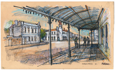 The Beechworth Burke Museum
Drawing, Ernest Marcuse, Beechworth III, c1972-1976
Ernest Heinrich Marcuse was born on the 1st of December 1900 to Hedwig and Siegmund Marcuse in Berlin Germany. While Marcuse's artistic talent was apparent from a younger age, his earliest existing artwork was from when he was approximately 20 years old. Ernest's formal art training commenced in 1918 with a three year course at the Berlin school of Interior design. After completion he found work until 1924 when Germany's Great Depression took effect. To broaden his career opportunities he undertook a further 12 months study of fashion, drawing and advertising at Berlin's Reiman school of art. From 1925 to 1934 Ernest was primarily a freelance press artist specialising in industrial, architectural and figurative drawing. Prominent newspaper The Berliner Morgenpost was his largest client along with Gross Deutsche Rundfunaustellung (Germany's organisation for major trade shows). During this period he would create many significant works. Two months after Hitler and the Nazi part came to power in 1933, Ernest received a life changing letter stating that being Jewish he could no longer continue employment in Germany. Up until 1938 he would only be able to undertake private commissions and occasional unofficial work as a book illustrator and games designer. This was by arrangement with non Jewish artists who claimed his work as their own, they would then share the income with Ernest. With increasing unrest in Germany during late 1938 Ernest decided to move to London and there he married his girlfriend Lotte. In late 1939 Ernest and Lotte Marcuse embarked on an eight week journey to their new home in Australia where they had been accepted as refugees. Shortly after arriving in Australia Ernest presented his portfolio to an editor at the Argus newspaper and gained employment as a war events illustrator. He soon became well respected and known in particular for his detailed illustrations and cross sections of ships , artillery and aircrafts. His detailed depictions of battles were displayed on the front pages of The Argus newspaper on a number of occasions. In May 1940 as the war intensified Ernest was dismissed from The Argus newspaper due to his Australian government classification of 'stateless person of enemy origin' and was considered a potential security risk. The editor of the time commented "don't blame us, blame Hitler". Marcuse then began to establish himself as a commercial artist. Ernest was de-classified as a 'stateless person of enemy origin' and in early 1942. The Australian army heard of Ernest's artistic abilities and began to utilize his designs for visual training aids and posters. Ernest became Private E.H Marcuse V377746, his first army posting was as staff artist at The infantry officer's training school at Bonegilla. When off duty he was inspired by the beauty of the surrounding area creating the works in North east Victoria 'Kiewa river bridge', 'Hume weir', ' Dried up river bed' and 'Hawksview gold reef mine' from his 1942-1943 period at Bonegilla Victoria. Ernest returned to the area to create drawings and paintings from 1948 to 1983 in locations including Bright, Wandilligong, Bogong High plains and Wallace's Hut, Mt Buffalo, Beechworth, Pretty valley, Kiewa Hydro, Yackandandah and Bontherambo homestead. These sketches were often completed on location, photographs were also taken onsite to assist the works back at the studio. Occasionally Marcuse also painted in the field. Ernest's preferred choice of medium was pencil and ink. Up until 1952 he would often incorporate watercolour into his work. Later into his career he began introducing pastels, acrylic and mixed media. In earlier years Ernest Marcuse often signed his work Mar, later on the signing of works ranged from Marcuse, E.Marcuse, Ernest Marcuse, EHM or simply EM . If a work was considered incomplete or Marcuse did not like the work it would remain unsigned. From Bonegilla Marcuse was transferred to Woodside South Australia before his final posting in Melbourne until the end of 1945. Ernest's work from within his army posting 'Troop Train at Night' from his 1945 exhibition Australia at War are part of the permanent collection at Canberra's War Museum. Between 1946 and 1969 Ernest largely worked from home and concentrated on a career as a freelance commercial artist and graphic designer. During that time he created work for well known household names including CRA/Conzinc, Vacuum oil (Caltex), Cottee's Brand (Schweppes and Heinz), Home Beautiful magazine Fulton garden supplies, International Iveco trucks, Ego pharmaceuticals, QV and Sunsense. After retirement Ernest concentrated on his true love of fine art and focused on painting images of personal interest both across Australia and Internationally. Earnest never drove a car. He would often walk or use public transport or enlist in the help of family or artist friends to drive him. Throughout his career Ernest Marcuse's artworks were purchase by private collectors these included ACTU, Melbourne City council, Holland Constructions, Melbourne Metropolitan Tramways Board, GJ Coles and Australian Resources Bank. Ernest Marcuse permanent collections can be viewed at The National Gallery of Victoria , Sydney Jewish Museum, Jewish Holocaust Centre Melbourne, Canberra's War Museum, City of Melbourne, Shire of Yarra ranges and now the Burke Museum. © 2020 Art by Marcuse https://www.artbymarcuse.com.au/aboutDonated to the Burke Museum through the Australian Government's Cultural Gifts Program by Peter and Evelyn MarcusePen and coloured pencil landscape drawing on paper.Obverse: BEECHWORTH / VIC. / MARCUSE Reverse: BEECHWORTH NOSTALGIA / BW – 03 (on masking tape) 003 (pencil) ernest marcuse, marcuse, art, artbymarcuse, beechworth, burke museum, indigo shire, landscape, illustration, drawing, pen and pencil, australian army, war events illustrator, the age, the sun, the argus, germany, refugee, industrial drawing, architectual drawing, figure drawing, berliner morgenpost, grosse deutsche rundfunaustellung, berlin’s reiman school of art., cultural gifts program -
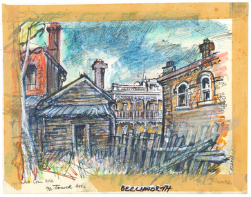 The Beechworth Burke Museum
Drawing, Ernest Marcuse, Beechworth – Opposite Crown Hotel (Tanswell Hotel), c1972-1976
Ernest Heinrich Marcuse was born on the 1st of December 1900 to Hedwig and Siegmund Marcuse in Berlin Germany. While Marcuse's artistic talent was apparent from a younger age, his earliest existing artwork was from when he was approximately 20 years old. Ernest's formal art training commenced in 1918 with a three year course at the Berlin school of Interior design. After completion he found work until 1924 when Germany's Great Depression took effect. To broaden his career opportunities he undertook a further 12 months study of fashion, drawing and advertising at Berlin's Reiman school of art. From 1925 to 1934 Ernest was primarily a freelance press artist specialising in industrial, architectural and figurative drawing. Prominent newspaper The Berliner Morgenpost was his largest client along with Gross Deutsche Rundfunaustellung (Germany's organisation for major trade shows). During this period he would create many significant works. Two months after Hitler and the Nazi part came to power in 1933, Ernest received a life changing letter stating that being Jewish he could no longer continue employment in Germany. Up until 1938 he would only be able to undertake private commissions and occasional unofficial work as a book illustrator and games designer. This was by arrangement with non Jewish artists who claimed his work as their own, they would then share the income with Ernest. With increasing unrest in Germany during late 1938 Ernest decided to move to London and there he married his girlfriend Lotte. In late 1939 Ernest and Lotte Marcuse embarked on an eight week journey to their new home in Australia where they had been accepted as refugees. Shortly after arriving in Australia Ernest presented his portfolio to an editor at the Argus newspaper and gained employment as a war events illustrator. He soon became well respected and known in particular for his detailed illustrations and cross sections of ships , artillery and aircrafts. His detailed depictions of battles were displayed on the front pages of The Argus newspaper on a number of occasions. In May 1940 as the war intensified Ernest was dismissed from The Argus newspaper due to his Australian government classification of 'stateless person of enemy origin' and was considered a potential security risk. The editor of the time commented "don't blame us, blame Hitler". Marcuse then began to establish himself as a commercial artist. Ernest was de-classified as a 'stateless person of enemy origin' and in early 1942. The Australian army heard of Ernest's artistic abilities and began to utilize his designs for visual training aids and posters. Ernest became Private E.H Marcuse V377746, his first army posting was as staff artist at The infantry officer's training school at Bonegilla. When off duty he was inspired by the beauty of the surrounding area creating the works in North east Victoria 'Kiewa river bridge', 'Hume weir', ' Dried up river bed' and 'Hawksview gold reef mine' from his 1942-1943 period at Bonegilla Victoria. Ernest returned to the area to create drawings and paintings from 1948 to 1983 in locations including Bright, Wandilligong, Bogong High plains and Wallace's Hut, Mt Buffalo, Beechworth, Pretty valley, Kiewa Hydro, Yackandandah and Bontherambo homestead. These sketches were often completed on location, photographs were also taken onsite to assist the works back at the studio. Occasionally Marcuse also painted in the field. Ernest's preferred choice of medium was pencil and ink. Up until 1952 he would often incorporate watercolour into his work. Later into his career he began introducing pastels, acrylic and mixed media. In earlier years Ernest Marcuse often signed his work Mar, later on the signing of works ranged from Marcuse, E.Marcuse, Ernest Marcuse, EHM or simply EM . If a work was considered incomplete or Marcuse did not like the work it would remain unsigned. From Bonegilla Marcuse was transferred to Woodside South Australia before his final posting in Melbourne until the end of 1945. Ernest's work from within his army posting 'Troop Train at Night' from his 1945 exhibition Australia at War are part of the permanent collection at Canberra's War Museum. Between 1946 and 1969 Ernest largely worked from home and concentrated on a career as a freelance commercial artist and graphic designer. During that time he created work for well known household names including CRA/Conzinc, Vacuum oil (Caltex), Cottee's Brand (Schweppes and Heinz), Home Beautiful magazine Fulton garden supplies, International Iveco trucks, Ego pharmaceuticals, QV and Sunsense. After retirement Ernest concentrated on his true love of fine art and focused on painting images of personal interest both across Australia and Internationally. Earnest never drove a car. He would often walk or use public transport or enlist in the help of family or artist friends to drive him. Throughout his career Ernest Marcuse's artworks were purchase by private collectors these included ACTU, Melbourne City council, Holland Constructions, Melbourne Metropolitan Tramways Board, GJ Coles and Australian Resources Bank. Ernest Marcuse permanent collections can be viewed at The National Gallery of Victoria , Sydney Jewish Museum, Jewish Holocaust Centre Melbourne, Canberra's War Museum, City of Melbourne, Shire of Yarra ranges and now the Burke Museum. © 2020 Art by Marcuse https://www.artbymarcuse.com.au/aboutDonated to the Burke Museum through the Australian Government's Cultural Gifts Program by Peter and Evelyn MarcusePen and coloured pencil landscape drawing on paper.Obverse: Opposite Crown Hotel / Tanswell Hotel / BEECHWORTH / (on tape) Reverse: BEECHWORTH NOSTALGIA / BW – 05 (on masking tape) 004 (pencil) ernest marcuse, marcuse, art, artbymarcuse, beechworth, burke museum, indigo shire, landscape, illustration, drawing, pen and pencil, australian army, war events illustrator, the age, the sun, the argus, germany, refugee, industrial drawing, architectual drawing, figure drawing, berliner morgenpost, grosse deutsche rundfunaustellung, berlin’s reiman school of art., cultural gifts program -
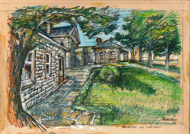 The Beechworth Burke Museum
Drawing, Ernest Marcuse, Beechworth – Old Court House, 1972
Ernest Heinrich Marcuse was born on the 1st of December 1900 to Hedwig and Siegmund Marcuse in Berlin Germany. While Marcuse's artistic talent was apparent from a younger age, his earliest existing artwork was from when he was approximately 20 years old. Ernest's formal art training commenced in 1918 with a three year course at the Berlin school of Interior design. After completion he found work until 1924 when Germany's Great Depression took effect. To broaden his career opportunities he undertook a further 12 months study of fashion, drawing and advertising at Berlin's Reiman school of art. From 1925 to 1934 Ernest was primarily a freelance press artist specialising in industrial, architectural and figurative drawing. Prominent newspaper The Berliner Morgenpost was his largest client along with Gross Deutsche Rundfunaustellung (Germany's organisation for major trade shows). During this period he would create many significant works. Two months after Hitler and the Nazi part came to power in 1933, Ernest received a life changing letter stating that being Jewish he could no longer continue employment in Germany. Up until 1938 he would only be able to undertake private commissions and occasional unofficial work as a book illustrator and games designer. This was by arrangement with non Jewish artists who claimed his work as their own, they would then share the income with Ernest. With increasing unrest in Germany during late 1938 Ernest decided to move to London and there he married his girlfriend Lotte. In late 1939 Ernest and Lotte Marcuse embarked on an eight week journey to their new home in Australia where they had been accepted as refugees. Shortly after arriving in Australia Ernest presented his portfolio to an editor at the Argus newspaper and gained employment as a war events illustrator. He soon became well respected and known in particular for his detailed illustrations and cross sections of ships , artillery and aircrafts. His detailed depictions of battles were displayed on the front pages of The Argus newspaper on a number of occasions. In May 1940 as the war intensified Ernest was dismissed from The Argus newspaper due to his Australian government classification of 'stateless person of enemy origin' and was considered a potential security risk. The editor of the time commented "don't blame us, blame Hitler". Marcuse then began to establish himself as a commercial artist. Ernest was de-classified as a 'stateless person of enemy origin' and in early 1942. The Australian army heard of Ernest's artistic abilities and began to utilize his designs for visual training aids and posters. Ernest became Private E.H Marcuse V377746, his first army posting was as staff artist at The infantry officer's training school at Bonegilla. When off duty he was inspired by the beauty of the surrounding area creating the works in North east Victoria 'Kiewa river bridge', 'Hume weir', ' Dried up river bed' and 'Hawksview gold reef mine' from his 1942-1943 period at Bonegilla Victoria. Ernest returned to the area to create drawings and paintings from 1948 to 1983 in locations including Bright, Wandilligong, Bogong High plains and Wallace's Hut, Mt Buffalo, Beechworth, Pretty valley, Kiewa Hydro, Yackandandah and Bontherambo homestead. These sketches were often completed on location, photographs were also taken onsite to assist the works back at the studio. Occasionally Marcuse also painted in the field. Ernest's preferred choice of medium was pencil and ink. Up until 1952 he would often incorporate watercolour into his work. Later into his career he began introducing pastels, acrylic and mixed media. In earlier years Ernest Marcuse often signed his work Mar, later on the signing of works ranged from Marcuse, E.Marcuse, Ernest Marcuse, EHM or simply EM . If a work was considered incomplete or Marcuse did not like the work it would remain unsigned. From Bonegilla Marcuse was transferred to Woodside South Australia before his final posting in Melbourne until the end of 1945. Ernest's work from within his army posting 'Troop Train at Night' from his 1945 exhibition Australia at War are part of the permanent collection at Canberra's War Museum. Between 1946 and 1969 Ernest largely worked from home and concentrated on a career as a freelance commercial artist and graphic designer. During that time he created work for well known household names including CRA/Conzinc, Vacuum oil (Caltex), Cottee's Brand (Schweppes and Heinz), Home Beautiful magazine Fulton garden supplies, International Iveco trucks, Ego pharmaceuticals, QV and Sunsense. After retirement Ernest concentrated on his true love of fine art and focused on painting images of personal interest both across Australia and Internationally. Earnest never drove a car. He would often walk or use public transport or enlist in the help of family or artist friends to drive him. Throughout his career Ernest Marcuse's artworks were purchase by private collectors these included ACTU, Melbourne City council, Holland Constructions, Melbourne Metropolitan Tramways Board, GJ Coles and Australian Resources Bank. Ernest Marcuse permanent collections can be viewed at The National Gallery of Victoria , Sydney Jewish Museum, Jewish Holocaust Centre Melbourne, Canberra's War Museum, City of Melbourne, Shire of Yarra ranges and now the Burke Museum. © 2020 Art by Marcuse https://www.artbymarcuse.com.au/aboutDonated to the Burke Museum through the Australian Government's Cultural Gifts Program by Peter and Evelyn MarcusePen and coloured pencil landscape drawing on paper.Obverse: Marcuse / Beechworth Old Courthouse / Reverse: B4 / BEECHWORTH OLD COURTHOUSE / BW - 09 (on masking tape) COURTHOUSE / BEECHWORTH / VICTORIA / NATIONAL TRUST / CLASS (A) ERNEST MARCUSE / 17 CADDOCK AVE / CAUFIELD / VIC / 53-7374 001 (pencil) ernest marcuse, marcuse, art, artbymarcuse, beechworth, burke museum, indigo shire, landscape, illustration, drawing, pen and pencil, australian army, war events illustrator, the age, the sun, the argus, germany, refugee, industrial drawing, architectual drawing, figure drawing, berliner morgenpost, grosse deutsche rundfunaustellung, berlin’s reiman school of art., cultural gifts program -
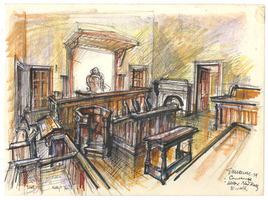 The Beechworth Burke Museum
Drawing, Ernest Marcuse, Courthouse - Beechworth, 1974
Ernest Heinrich Marcuse was born on the 1st of December 1900 to Hedwig and Siegmund Marcuse in Berlin Germany. While Marcuse's artistic talent was apparent from a younger age, his earliest existing artwork was from when he was approximately 20 years old. Ernest's formal art training commenced in 1918 with a three year course at the Berlin school of Interior design. After completion he found work until 1924 when Germany's Great Depression took effect. To broaden his career opportunities he undertook a further 12 months study of fashion, drawing and advertising at Berlin's Reiman school of art. From 1925 to 1934 Ernest was primarily a freelance press artist specialising in industrial, architectural and figurative drawing. Prominent newspaper The Berliner Morgenpost was his largest client along with Gross Deutsche Rundfunaustellung (Germany's organisation for major trade shows). During this period he would create many significant works. Two months after Hitler and the Nazi part came to power in 1933, Ernest received a life changing letter stating that being Jewish he could no longer continue employment in Germany. Up until 1938 he would only be able to undertake private commissions and occasional unofficial work as a book illustrator and games designer. This was by arrangement with non Jewish artists who claimed his work as their own, they would then share the income with Ernest. With increasing unrest in Germany during late 1938 Ernest decided to move to London and there he married his girlfriend Lotte. In late 1939 Ernest and Lotte Marcuse embarked on an eight week journey to their new home in Australia where they had been accepted as refugees. Shortly after arriving in Australia Ernest presented his portfolio to an editor at the Argus newspaper and gained employment as a war events illustrator. He soon became well respected and known in particular for his detailed illustrations and cross sections of ships , artillery and aircrafts. His detailed depictions of battles were displayed on the front pages of The Argus newspaper on a number of occasions. In May 1940 as the war intensified Ernest was dismissed from The Argus newspaper due to his Australian government classification of 'stateless person of enemy origin' and was considered a potential security risk. The editor of the time commented "don't blame us, blame Hitler". Marcuse then began to establish himself as a commercial artist. Ernest was de-classified as a 'stateless person of enemy origin' and in early 1942. The Australian army heard of Ernest's artistic abilities and began to utilize his designs for visual training aids and posters. Ernest became Private E.H Marcuse V377746, his first army posting was as staff artist at The infantry officer's training school at Bonegilla. When off duty he was inspired by the beauty of the surrounding area creating the works in North east Victoria 'Kiewa river bridge', 'Hume weir', ' Dried up river bed' and 'Hawksview gold reef mine' from his 1942-1943 period at Bonegilla Victoria. Ernest returned to the area to create drawings and paintings from 1948 to 1983 in locations including Bright, Wandilligong, Bogong High plains and Wallace's Hut, Mt Buffalo, Beechworth, Pretty valley, Kiewa Hydro, Yackandandah and Bontherambo homestead. These sketches were often completed on location, photographs were also taken onsite to assist the works back at the studio. Occasionally Marcuse also painted in the field. Ernest's preferred choice of medium was pencil and ink. Up until 1952 he would often incorporate watercolour into his work. Later into his career he began introducing pastels, acrylic and mixed media. In earlier years Ernest Marcuse often signed his work Mar, later on the signing of works ranged from Marcuse, E.Marcuse, Ernest Marcuse, EHM or simply EM . If a work was considered incomplete or Marcuse did not like the work it would remain unsigned. From Bonegilla Marcuse was transferred to Woodside South Australia before his final posting in Melbourne until the end of 1945. Ernest's work from within his army posting 'Troop Train at Night' from his 1945 exhibition Australia at War are part of the permanent collection at Canberra's War Museum. Between 1946 and 1969 Ernest largely worked from home and concentrated on a career as a freelance commercial artist and graphic designer. During that time he created work for well known household names including CRA/Conzinc, Vacuum oil (Caltex), Cottee's Brand (Schweppes and Heinz), Home Beautiful magazine Fulton garden supplies, International Iveco trucks, Ego pharmaceuticals, QV and Sunsense. After retirement Ernest concentrated on his true love of fine art and focused on painting images of personal interest both across Australia and Internationally. Earnest never drove a car. He would often walk or use public transport or enlist in the help of family or artist friends to drive him. Throughout his career Ernest Marcuse's artworks were purchase by private collectors these included ACTU, Melbourne City council, Holland Constructions, Melbourne Metropolitan Tramways Board, GJ Coles and Australian Resources Bank. Ernest Marcuse permanent collections can be viewed at The National Gallery of Victoria , Sydney Jewish Museum, Jewish Holocaust Centre Melbourne, Canberra's War Museum, City of Melbourne, Shire of Yarra ranges and now the Burke Museum. © 2020 Art by Marcuse https://www.artbymarcuse.com.au/aboutDonated to the Burke Museum through the Australian Government's Cultural Gifts Program by Peter and Evelyn MarcusePen and coloured pencil landscape drawing on paper.Obverse: Marcuse 74 / Courthouse / Visitor Ned Kelly . B'worth Reverse: BEECHWORTH / COURTHOUSE / B5 / 06 ernest marcuse, marcuse, art, artbymarcuse, beechworth, burke museum, indigo shire, landscape, illustration, drawing, pen and pencil, australian army, war events illustrator, the age, the sun, the argus, germany, refugee, industrial drawing, architectual drawing, figure drawing, berliner morgenpost, grosse deutsche rundfunaustellung, berlin’s reiman school of art., cultural gifts program