Showing 148 items matching "department of land and survey"
-
 University of Melbourne, Burnley Campus Archives
Plan, [Historical Maps of Richmond Park], 1862-2000
(1) Proposed reserve for Horticultural & Experimental Garden in the Survey paddock Richmond. R.19A (1865). Shows Swan Street Extension. Gazettals 1877, 1887. (2) As (1). Half of map only Annotation by A. Purchas, 9 October, 1862. (3) Plan of Richmond park. A.L. Martin Authorised Surveyor, 31st August, 1872. [Dept. of lands & Survey Melbourne, J. Noone, 6th September 1872.] Map in 4 sheets. (4) Richmond Park. Surveyed by Geo. Black, Authorised Surveyor 13.8.91 (2 copies). (5) [Richmond Park] Shows road alignments gazetted 1871 & 1881 (part copy only - Neg. 18375). (6) City of Richmond Parish of Jika Jika County of Bourke. Department of lands & Survey, 1919 (annotations i.e. Melb. City Link, Amrad, etc. to 1994.) (7) Burnley gardens, 2000. Produced by P. Tulk, Institute of Land & Food Resources, Burnley College, 2000 (re area proposed for heritage listing.)richmond park, survey paddock -
 City of Greater Bendigo - Civic Collection
Instrument - Gunter Chain, not known
Gunter's chain (also known as Gunter’s measurement) is a distance measuring device used for surveying. It was designed and introduced in 1620 by English clergyman and mathematician Edmund Gunter (1581–1626). It enabled plots of land to be accurately surveyed and plotted, for legal and commercial purposes. The provenance of this particular Gunter Chain is unknown but it is believed to be used either by the City of Bendigo / Sandhurst or the Lands Department locally when measuring and laying out plots and streets locally. A 66-foot (20.1 m) chain divided into 100 links, marked off into groups of 10 by brass rings or tags. Each link is 7.92 inches (201 mm) long. A quarter chain, or 25 links, measures 16 feet 6 inches (5.03 m) also called a a rod (or pole) measure. Ten chains measure a furlong and 80 chains measure a statute mile. city of greater bendigo surveying -
 City of Greater Bendigo - Civic Collection
Administrative record - Land Sales, A. J. Mullet Government Printer et al, 1927
This type of album was made by agents auctioning and selling land.Large portfolio style album with dark green / black cloth cover bound with three large metal pins. Forty eight pages with twenty seven Department of Lands and Survey maps and newspaper clippings about land sales and auction details pasted in. Index page. Maps have handwritten notes and markings throughout in pencil and pen. Covers the County's of Gunbower and Tatchera. Includes a receipt slip with hand written notes on reverse on William Wallace & Co letterhead. city of bendigo commerce -
 City of Greater Bendigo - Civic Collection
Administrative record - Land Sales, Department of Lands and Survey et al, 1929
... . Administrative record Land Sales Department of Lands and Survey A. J ...This type of album was created by agents auctioning and selling land.Large portfolio style album with green cloth cover bound with three large metal pins. One hundred and then pages with thirty three Department of Lands and Survey maps pasted in. Index page. Maps have handwritten notes and markings throughout in pencil and pen. Covers the Counties of Bendigo, Rodney, Talbot, Gunbower, Gladstone, Tatchera and Karkarooc, Shires of East Loddon and Huntly and Swan Hill District. -
 City of Greater Bendigo - Civic Collection
Administrative record - Land Sales, A. J. Mullet Government Printer, 1927
This type of album was created by agents auctioning and selling land.Large portfolio style album with black cloth cover bound with three large metal pins. Blue marbled pastedown endpapers. Seventy nine pages, seventy five with Department of Lands and Survey maps attached. No index page. Maps have handwritten notes and markings throughout in pencil and pen. Covers the Counties of Bendigo, Rodney, Gladstone and Talbot and Parishes of Kerang, Salisbury, Mandurang and Tarnagulla. Includes a hand written note on William Wallace & Co letterhead. city of bendigo commerce -
 City of Kingston
Photograph - Black and white, 20 December 1945
Cheltenham is a suburb in the City of Kingston that was originally established as a rural market gardening community. The area is bordered by Highett, Mentone and Heatherton. The market gardens, farms and paddocks have gradually been sub-divided into housing and industrial estates. The Southland shopping centre is a major feature of the area.Cheltenham was established as a rural market gardening community. The Le Page family lived in Cheltenham since 1854 when Nicholas Le Page, a tailor from the Channel Island of Guernsey, bought two acres of land on Chesterville Road near Bernard Street to establish a market garden. Over the years the Le Pages purchased more land in the area. In 1875-76 Nicholas' son Frank and his wife Mary built 'Daphne Cottage' near the corner of Bernard and Wilson Streets. n the 1940s Frank's son, Everest Le Page, bought five more lots of land in Chesterville Road from the Tuck family. The Le Pages grazed horses, ponies and cows on this land, and grew pumpkins, carrots, parsnips, onions, potatoes and cabbages. Many buildings and locations within in Cheltenham commemorate the Le Page family's contribution to the Cheltenham community.Aerial photograph taken in 1945 of the Cheltenham district within the City of Kingston. The image includes Chesterville Road, the future site of Turner Road pool (now Waves) and Highett Reserve, (top left), Jellicoe Street, Argus Street, Bernard Street, Wilson Street, the Methodist Children Homes (now Southland), McIvor Street, Goulburn Street, Nepean Highway, Jamieson Street and Barker Street (bottom left), market gardens and paddocks. In the top centre of the image, "Daphne Cottage", the home of Frank T. Le Page is visible on the corner of Bernard and Wilson Streets. Much of the land depicted in this image was owned by the Le Page family. This image is possibly from the collection of aerial photographs commissioned by the Department of Crown Lands and Survey and taken by Adastra Airways.Black and white ink: 57250 White print: VIC-170 57250 20.12.45 Run 6 PROJ. No. 5 MELB. METROP AREA Black type 10200 FTS 30' LENS 20.12.45cheltenham, market gardens, industry, le page family -
 City of Kingston
Photograph - Black and white, 20 December 1945
This aerial photograph depicts the changing landscape of Cheltenham and Highett since WWII. Photographed in 1945, there is a mix of urban dwellings and industrial development and precedes the major transformation of Cheltenham with the development of the Southland shopping centre in the 1960s and expansion in the 1990s.A large part of Cheltenham was originally established as a rural market gardening community. The railway line and station brought urban development to the area and in the north, the Highett area was dominated by the Highett Gas Works. Cheltenham became a major destination for shopping in the 1960s with the opening of Southland.Aerial photograph taken in 1945 of Cheltenham and Highett within the City of Kingston. The image includes the Highett Reserve, (top right), the Methodist Children Homes (now Southland), Nepean Highway and Jamieson Street. Highett Gas Works is visible in the top left and the land now named William Fry Reserve at the intersection of Bay Road and Nepean Highway. A visible large parcel of land on the corner of Bay Road and Nepean Highway was developed in the 1990s as the west side addition to Southland. The densely vegetated area in the upper right sector of the image is now dense with housing. Tulip Grove, Heather Grove and Gilford Street are visible bottom left. This image is possibly from the collection of aerial photographs commissioned by the Department of Crown Lands and Survey and taken by Adastra Airways.Black ink: 57252 White lettering: VIC-10 57252 20.12.45 [lens information indecipherable] PROJ. No.5 MELB. METROP AREA Black pencil: 80highett, cheltenham, highett gas works, urbanisation -
 City of Kingston
Photograph - Black and white, 20 December 1945
This aerial photograph depicts the changing landscape of Cheltenham and Highett since WWII. Photographed in 1945, there is a mix of urban dwellings and industrial development and precedes the major transformation of Cheltenham with the development of the Southland shopping centre in the 1960s and expansion in the 1990s.A large part of Cheltenham was originally established as a rural market gardening community. The railway line and station brought urban development to the area and in the north, the Highett area was dominated by the Highett Gas Works. Cheltenham became a major destination for shopping in the 1960s with the opening of Southland.Aerial photograph taken in 1945 of Cheltenham and Highett within the City of Kingston. The image includes the Highett Reserve, (top right), the Methodist Children Homes (now Southland), Nepean Highway and Jamieson Street. Highett Gas Works is visible in the top left and the land now named William Fry Reserve at the intersection of Bay Road and Nepean Highway. A visible large parcel of land on the corner of Bay Road and Nepean Highway was developed in the 1990s as the west side addition to Southland. The densely vegetated area in the upper right sector of the image is now dense with housing. Tulip Grove, Heather Grove and Gilford Street are visible bottom left. This image is possibly from the collection of aerial photographs commissioned by the Department of Crown Lands and Survey and taken by Adastra Airways.Black type: Reverse lettering VIC-10 57252 20.12.45 [lens information indecipherable] PROJ. No.5 MELB. METROP AREA White lettering: Reverse writing 57252cheltenham, highett, highett gas works, urbanisation -
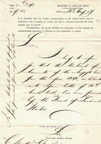 Linton and District Historical Society Inc
Letter, Paper manufactured by T. Edmonds 1890 (watermark), Department of Lands and Survey, Argyle Common, Linton, 1897, 18.05.1897
Letter written on behalf of Tho. MacGibbon, Secretary for Lands, to C. Stratton, Secretary, Argyle Common, Linton. Acknowledging receipt of Argyle Common accounts for 1896, and informing of their passing by the Board of Land and Parks. Also requesting that in future the accounts should be prepared on the prescribed form, a copy of which was enclosed. Found in the home of Miss Margaret Gorman after her death. See form sent with letter - Registration No. 1617Handwritten letter on grey paper headed Department of Lands and Survey, dated 18th May 1897. Addressee C. Stratton Esq.-Secretary-Argyle Common-Linton.argyle common linton, animal grazing, agricultural activity -
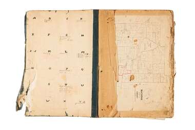
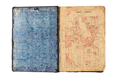
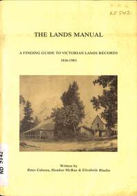 Whitehorse Historical Society Inc.
Manual - Government (Lands Dept), Royal Historical Society of Victoria, The Lands Manual - A Finding Guide to Victorian Land Records 1836 - 1983, March 1989
The manual documents the archives of the Department of Crown Lands and Survey (Lands Department) between 1836 to 1983 and explains how they can be used for historical research.The manual documents the archives of the Department of Crown Lands and Survey (Lands Department) and explains how they can be used for historical research.The manual documents the archives of the Department of Crown Lands and Survey (Lands Department) between 1836 to 1983 and explains how they can be used for historical research.crown lands, victoria. department of crown lands and survey -
 Bacchus Marsh & District Historical Society
Map, Village allotments, Parish of Myrniong, County of Bourke
Myrniong is a village 9 kilometers west of Bacchus Marsh. Prior to 1863 the area was known as Blow's Flat. This map which was produced in 1903 and according to the catalogue record of this map held at the State Library of Victoria was based on an earlier map created in 1861. The early layout of streets for the village of Myrniong can be seen on this map. The streets shown are, Main Street, Hardy Street, Blow Street, Myrniong Street, Shuter Street, and Blackwood Street. An area marked as a reserve for a school can be seen between Hardy Street and Main Street.A single page paper map. A cadastral parish map of Myrniong in Victoria, showing numbered land allotments. Photo-lithographed at the Department of Lands & Survey, Melbourne, in 1903. Based on an original map created in 1861. The map is pasted into a bound volume containing 76 maps or plans in total. High resolution digital image stored on BMDHS computer network. Surveyed by John Hardy, Surveyor ; photo-lithographed at the Department of Lands & Survey, Melbourne by T.F. McGauran, 24.12.03myrniong parish plan, myrniong parish maps -
 Bacchus Marsh & District Historical Society
Map, Parwan Parish Map, County of Grant, 1909
A single page paper map showing the map for the Parish of Parwan in the County of Grant. A cadastral map showing parish boundaries and land ownership. The map is pasted into a bound volume containing 76 maps or plans in total. High resolution digital image stored on BMDHS computer network. Photo-lithographed at the Department of Lands and Survey, Melbourne by T.F. McGauran, 7.7.09. bacchus marsh region parish plans, parwan parish maps, parwan parish plan -
 Bacchus Marsh & District Historical Society
Map, Trentham Parish Map 1905 Copy 1
A single page paper map showing the map for the Parish of Trentham in the Counties of Dalhousie and Bourke. A cadastral map showing parish boundaries and land ownership. The map is pasted into a bound volume containing 76 maps or plans in total. High resolution digital image stored on BMDHS computer network. Photo-lithographed at the Department of Lands and Survey, Melbourne by T.F. McGauran 22.3.05 trentham parish maps, trentham parish plan, bacchus marsh region parish plans -
 Bacchus Marsh & District Historical Society
Map, Coimadai Parish Map, County of Bourke. Circa 1890s-1900s
... Photo-lithographed at the Department of Lands and Survey... was in charge of photo-lithography at the Victorian Department of Lands ...The cadastral Parish of Coimadai, a subdivision of the County of Bourke, lies directly north of the township of Bacchus Marsh. The date of this map is uncertain. T.F. McGauran the person who made a photo-lithographic copy of the map was in charge of photo-lithography at the Victorian Department of Lands and Survey in the late 19th century until about 1910.A single page paper map showing the map for the Parish of Coimadai in the County of Bourke. A cadastral map showing parish boundaries and land ownership. A rectangle shaped area is missing from the centre of the map due to a tear or deliberate excision. The map is pasted into a bound volume containing 76 maps or plans in total. High resolution digital image stored on BMDHS computer network. Photo-lithographed at the Department of Lands and Survey, Melbourne by T.F. McGauran 26.8.[??] NOTE. Photo litho from L.P showing temporary surveys and occupation of land prepared for departmental use onlybacchus marsh region parish plans, coimadai parish maps, coimadai parish plan -
 Bacchus Marsh & District Historical Society
Map, Blackwood Parish Map, County of Bourke, 1892
A single page paper map showing the map for the Parish of Blackwood in the County of Bourke. A cadastral map showing parish boundaries and land ownership. The map is pasted into a bound volume containing 76 maps or plans in total. High resolution digital image stored on BMDHS computer network. Photo-lithographed at the Department of Lands and Survey, Melbourne by T.F. McGauran 14.7.92bacchus marsh region parish plans, blackwood parish plan, blackwood parish maps -
 Bacchus Marsh & District Historical Society
Map, Blackwood Parish Map, County of Bourke, 1905
A single page paper map showing the map for the Parish of Blackwood in the County of Bourke. A cadastral map showing parish boundaries and land ownership. The map is pasted into a bound volume containing 76 maps or plans in total. High resolution digital image stored on BMDHS computer network. Photo-lithographed at the Department of Lands and Survey, Melbourne by T.F. McGauran 21.7.05bacchus marsh region parish plans, blackwood parish plan, blackwood parish maps -
 Bacchus Marsh & District Historical Society
Map, Myrniong Parish Map, County of Bourke, 1882
A single page paper map showing the map for the Parish of Myrniong in the County of Bourke. A cadastral map showing parish boundaries and land ownership. The map is pasted into a bound volume containing 76 maps or plans in total. High resolution digital image stored on BMDHS computer network. Photo-lithographed at the Department of Lands and Survey, Melbourne by J. Noone, 17.7.82myrniong parish plan, myrniong parish maps, bacchus marsh region parish plans -
 Forests Commission Retired Personnel Association (FCRPA)
Beechworth FCV District office sign
This sign proudly hung outside the Forests Commission Victoria (FCV) Beechworth office which is now site of the Forestry Heritage Museum. The granite building in the Beechworth's historic precinct was once the Gold Warden's Office and is one of the town's original buildings. The FCV was the main government authority responsible for management and protection of State forests in Victoria between 1918 and 1983. The Commission was responsible for ″forest policy, prevention and suppression of bushfires, issuing leases and licences, planting and thinning of forests, the development of plantations, reforestation, nurseries, forestry education, the development of commercial timber harvesting and marketing of produce, building and maintaining forest roads, provision of recreation facilities, protection of water, soils and wildlife, forest research and making recommendations on the acquisition or alienation of land for forest purposes″. The Forests Commission had a long and proud history of innovation and of managing Victoria's State forests but in September 1983 lost its discrete identity when it was merged into the newly formed Victorian Department of Conservation, Forests and Lands (CFL) along with the Crown Lands and Survey Department, National Park Service, Soil Conservation Authority and Fisheries and Wildlife Service. After the amalgamation the management of State forests and the forestry profession continued but the tempo of change accelerated, with many more departmental restructures occurring over the subsequent four decades. Responsibilities are currently split between the Department of Energy, Environment and Climate Action (DEECA), Forests Fire Management Victoria (FFMV), Parks Victoria, Melbourne Water, Alpine Resorts Commission, the State Government-owned commercial entity VicForests and the privately owned Hancock Victorian Plantations (HVP).Large office sign. Hand painted in traditional FCV mission brown and gold colour scheme.forests commission victoria (fcv), forest signs -
 Ringwood and District Historical Society
Document - Department of Lands and Survey, Wire Netting Branch, Melbourne, Victoria, Application for Vermin-Proof Fence Certificate - L.J. Mills vs John Collins, Grandview Grove, Ringwood, Victoria - 1939
... reports by Vermin and Noxious Weeds Branch, Lands Department... and Noxious Weeds Branch, Lands Department, Lilydale, describing land ...Photocopied file of corresponence and documentation relating to a claim by L.J. Mills, Nurseryman, that adjoining property owner, J. Collins, Farmer, assists with replacement of a vermin proof wire netting dividing fence destroyed by 1939 bushfire. File includes 1939 and 1940 detailed property inspection reports by Vermin and Noxious Weeds Branch, Lands Department, Lilydale, describing land use in the area and signs of vermin activity. Application approved 18th April, 1940. Appeal lodged by Mr Collins disallowed in May, 1940. File closed June, 1940 with Departmental suggesion that Mr Mills consider further legal action through a Solicitor as fence had still not been wire-netted. TRANSCRIPTS: Vermin & Noxious Weeds Inspection Reports "19/9/1939 (To) Superintendent (Department of Lands and Survey, Melbourne) Re L.J. Mills application for Vermin Proof Fence. I called on Mr Mills yesterday 18th instant in connection with this matter. Mr Mills has a flower farm and claims that rabbits and hares are damaging his flowers. He showed me a bed of carnations which he stated were being damaged by rabbits. There was evidence of some leaves being nipped off, but I am unable to say whether this is due to rabbits or grubs. Very little if any real damage is being done. The property is netted on the east and south boundary and on half the north and west boundary. The surrounding country is undlating and fairly steep in places. The land to the east across Grandview Avenue (sic) is all planted out in old established orchards and well cultivated. Cleared grass land adjoins the south boundary and bush land adjoins the north and west boundaries. I walked over a large area surrounding Mr Mills land and never saw any rabbits or hares or any indications of rabbits. This locality is not rabbit infested and very little wire netting is being used. I do not consider that a vermin proof fence is necessary between these allotments. - Jas H Allison (Inspector, Vermin and Noxious Weeds Branch, Lands Department, Lilydale)." Follow up report following renewal of application for Certificate by Mr Mills, citing rabbits causing considerable damage to his flowers. He laid poison and obtained 9 carcases and stated that there is evidence of rabbit infestation from the adjoing land. "19/3/1940 (To) Mr Hannah (Superintendant, Department of Lands and Survey, Melbourne) Re L.J. Mills, Grandview Grove Ringwood, Lot 4 Grandview Estate Pt CG20 Ph of Warrandyte. I interviewed Mr Mills at his home on 15th inst. He showed me carcases of rabbits which he stated had been poisoned on his land. In places young plants had been nipped off apparently by rabbits. I made an inspection of adjoining properties and found one live burrow close to Mr Mills northern boundary. There were scratches and other evidence of rabbits on land north and west of Mr Mills property. In view of the present evidence of rabbits I consider that a vermin proof fence is now necessary to protect the flowers grown by Mr Mills. His land is netted on whole of east and south boundary and half way on west and north boundary. The adjoining land on west and north boundaries is owned by Mrs Linda Collins and John Collins resp of Brysons Road East Ringwood. - Jas H Allison (Inspector, Vermin and Noxious Weeds Branch, Lands Department, Lilydale)." -
 Flagstaff Hill Maritime Museum and Village
Map - Survey Map, F.F. McGovern, Yangery - County of Villiers, 1884
A surveyor was employed to measure the land designated as Yangery, County of Villiers, in the Borough of Warrnambool. The area on the map is similar to the earlier Farnham Survey undertaken by William Rutledge in the 1850's. Warrnambool was a Borough between 1863-1883. Coutours, waterways, sea and other significant points are shown. The distances are accurately measured. This survey map was used for planning future land sales, recreation areas and roads. WILLIAM RUTLEDGE (1806-1876) William Rutledge surveyed the land known as Farnham in southwest Victoria in 1843. His tenants made him a profitable business from working the land there. In 1863 Rutledge moved from nearby Port Fairy to Farnham and became very successful in breeding sheep, which he imported from J.R. Kirkham of Lincolnshire, England. He also bred horses on his land. The survey map of Yangery is important for its connection with renowned surveyor William Rutledge. The map shows the growth of landholders in the district when compared to the original Rutledge survey of the 1850's.Survey map of Yangery, titled "Yangery - County of Villiers". Printed on white paper, mounted on brown paper. c. 1863-1876. Comments printed on the Map include; Special Survey by William Rutledge, Photo-lithographed at the Department of Lands and Survey, Melbourne by W.J. Burson, Price 1/- [one shilling]. Scale is in Chains. Map has boundaries of Koroit Borough, Meerai, Purnim, Wangoom, Borough of Warrnambool, Mentions the Proposal of Tower HIll for Public Recreation. The map names the owners of the land at that time. Hand written pencil marks and figures and "Sauls fence" drawn on map. Hand written pencil markes and figures and "Sauls fence" drawn onto map. "For Department Use only". "Scale: 8 chains to 1 inch" flagstaff hill, warrnambool, shipwrecked-coast, flagstaff-hill, flagstaff-hill-maritime-museum, maritime-museum, shipwreck-coast, flagstaff-hill-maritime-village, county of villiers map, yangery district, w.j. burson, borough of warrnambool, koroit, purnim, meerai, wangoom, proposal of tower hill for public recreation, special survey by william rutledge, william rutledge, farnham, lincolnshire sheep, clydesdale -
 Bacchus Marsh & District Historical Society
Map, Mooradoranook Parish Map, County of Grant
A single page paper map showing the map for the Parish of Mooradanook in the County of Grant. Cadastral map showing land ownership. The map is pasted into a bound volume containing 76 maps or plans in total. High resolution digital image stored on BMDHS computer network. Photo lithographed at the Department of Lands and Survey Melbourne by T. F. McGauran, 27.11.06mooradoranook parish maps, mooradoranook parish plan, bacchus marsh region parish plans -
 Bacchus Marsh & District Historical Society
Map, Mouyong Parish Map, County of Grant
A single page paper map showing the map for the Parish of Mouyong in the County of Grant. Cadastral map showing land ownership. The map is pasted into a bound volume containing 76 maps or plans in total. High resolution digital image stored on BMDHS computer network. Photo lithographed at the Department of Lands and Survey Melbourne by T. F. McGauran, 9. 4. 07mouyong parish plan, mouyong parish maps, bacchus marsh region parish plans -
 Bendigo Historical Society Inc.
Document - VICTORIA HILL - RECOMMENDATION - MINING PROJECT
... . Repeater Station Mine's Department Land's Department Lansell ...Two (a & b) typed copy of a recommendation for mining project, accepted Nov. 1967. Recommendation for Central Nell Gwynne area, now a public purposes reserve for preservation as a permanent reminder of the gold mining era. Victoria Hill Area mentioned for it's geographical and historical significance. The New Chum Hill area rich in historical and mining. Notes on development of the Central Nell Gwynne, Victoria Hill and New or Old Chum Hill areas. Notes prepared by Albert Richardson.mine, gold, victoria hill, victoria hill, recommendation - mining project, central nell gwynne, jack barker, victoria hill area, big 180, victoria quartz, new chum hill (old chum hill), p. m. g. repeater station, mine's department, land's department, lansell, fortuna, a h q survey regiment, lazarus mine, b c v 8 television studio -
University of Melbourne, Burnley Campus Archives
Plan, Royal Botanic Gardens Melbourne, 1978
... Department of Crown Land and Survey Division of Survey and... Department of Crown Land and Survey Division of Survey and Mapping ...Plan of RBG with grid references. Produced by Dept. of Crown Lands and Survey, Victoria, Division of Survey and Mapping. Prepared in 1978 from surveys completed in 1976. (1) 2 copies plan. Main areas, buildings, etc., labelled, beds outlined. (2) Original coloured plan and reduced size photocopy. More labelling, particularly beds (handwritten). Labelled Jeremy J. Wallace with handwritten notes on reverse re a project. (3) Reduced size photocopy. Handwritten labelling of beds. (4 - 11) Enlarged photocopies of sections of (1) Handwritten notes and plant labelling. (1). Photgraphed copies by FRESCO 510131-TA. (12) Plan on a grid, coloured. "No Public Access," areas marked.jeremy j. wallace, royal botanical gardens melbourne, department of crown land and survey division of survey and mapping, ornamental lakes -
University of Melbourne, Burnley Campus Archives
Plan, Plan of Richmond Park, 1872
Plan of Richmond Park L4461. Shows Horticultural Society's Garden without extra land used for Field Station (see 11.0363, but earlier). Surveyed and drawn by A.L. Martin, Authorized Surveyor. Photo-lithographed at the Department of Lands and Survey, 6th Sept. 1872.Handwritten notes on reverse and another railway line marked in pencil.railway lines, swan street, yarra river, richmond park, horticultural society, orchard -
 University of Melbourne, Burnley Campus Archives
Plan, Plan of Richmond Park, 1886-1948
(1) Black and white photographed copy of an original coloured plan. Plan of Richmond Park with Horticultural Society Gardens marked in. Includes additional land which became the Field Station. Original plan dated 31 August 1872, note of Crown Grant to the Board of Land & Works and Richmond City Council 1886; showing land, "Permanently Preserved for the Gardens". Stamp, "Department of Lands and Survey Photographed at the Central Plan Office 1/1 Plate 7.12.48" (2) Also 2 photocopies, 1 reduced - possibly used in a publication1 photocopy has "Figure 1. Plan of Burnley Gardens circa 1863 [sic]gardens, richmond, horticultural society of victoria, richmond park, a.l. martin -
 Bendigo Historical Society Inc.
Document - MARKS COLLECTION: PARISH PLAN OF WHITE HILLS
Sepia coloured map showing allotments in Parish of Sandhurst (White Hills) Written on LH side of map town and Suburban Lots White Hills Parish of Sandhurst. Scale is shown in chains. Surveyed by Horage Walker. Photo lithographed at the Department of Lands & Survey, Melbourne by J.Noone, Price 1/-. 6th. January 1865. Map shows Race Course Reserve at top of sheet, Municipal boundary is marked on LH side. Comments re vegetation throughout map. For example, poor soil timbered with Box scrub.on the back--Plan of Land White Hills Sandhurstbendigo, planning, white hills parish map, horage walker, j noone, department of lands and survey, -
 Bendigo Historical Society Inc.
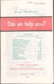
Book - MINING REPORTS - MINES DEPARTMENT CAN WE HELP YOU?
Small, 40-page paper booklet issued by E. Condon, Secretary of Mines, under the authority of The Hon. J. C. M. Balfour, MLA, Minister of Mines. The booklet was printed Melbourne, Victoria 1969. Topics include Assistance to Mining, Commencing Mining Operations, Concessions to Mining Industry, Miners Rights and Claims, Mining Leases and Licenses, Examination Boards, Gold Buying and Selling, Air Conditions in Mines, Cyanide Plant, State Crushing Batteries, Extractive Industries, Petroleum (On Land), Petroleum (Offshore), Pipelines, Explosives, Inflammable Liquids, Gas Meter Examination and Liquified Petroleum Gas.book, mining reports, mines department can we help you?, e condon, the hon j c m balfour, geological survey of victoria, mines department laboratories, explosives and gas examining branch, minister for mines, depot & core laboratory