Showing 242 items
matching documents - maps/plans
-
 Kew Historical Society Inc
Map, MMBW, MMBW Plan No.64 Kew & Heidelberg, 1900-1910
The Melbourne and Metropolitan Board of Works (MMBW) was established by an act of the Victorian Parliament in 1890 to prepare for and to implement a sewerage and water reticulation system across what was then inner Melbourne, its surrounding and middle distance suburbs, including Kew. The MMBW was disbanded in 1991.The map collection of the Kew Historical Society has at its core the historic maps assembled and originally stored in the City Engineer's Department of the City of Kew. These include maps in a number of scales. The vast majority of maps were produced by the MMBW in the first two decades of the twentieth century, and are solid working maps, backed by linen for durability. These maps are historically significant to Kew, the City of Boroondara and to the history of the development of state utilities in Victoria. A number of the Kew maps have additional details added by former municipal officers, including the levels reached by various floods. As these were working documents, information was added to them long after the period of their initial production and distribution.Early map of part of the Borough of Kew, created in the first decade of the twentieth century, at a scale 160 ft to 1 inch. The map covers what was then the northern most part of Kew, bordered on its north and west by the Yarra River, in the East by Connor's Creek and by the Asylum in the south. The map shows the extent of urban development by that time, prominent institutions and the outlines of built structures in the municipality. Contour lines and historic flood levels were added in ink to the map at a later stage.MELBOURNE AND METROPOLITAN BOARD OF WORKS / PLAN NO. 64 / KEW & HEIDELBERGmelbourne & metropolitan board of works, mmbw maps, mmbw plans, borough of kew, cartography -
 Kew Historical Society Inc
Map, MMBW, MMBW Plan No.65 Kew & Heidelberg, 1900-1910
The Melbourne and Metropolitan Board of Works (MMBW) was established by an act of the Victorian Parliament in 1890 to prepare for and to implement a sewerage and water reticulation system across what was then inner Melbourne, its surrounding and middle distance suburbs, including Kew. The MMBW was disbanded in 1991.The map collection of the Kew Historical Society has at its core the historic maps assembled and originally stored in the City Engineer's Department of the City of Kew. These include maps in a number of scales. The vast majority of maps were produced by the MMBW in the first two decades of the twentieth century, and are solid working maps, backed by linen for durability. These maps are historically significant to Kew, the City of Boroondara and to the history of the development of state utilities in Victoria. A number of the Kew maps have additional details added by former municipal officers, including the levels reached by various floods. As these were working documents, information was added to them long after the period of their initial production and distribution.Early map of part of the Borough of Kew, created in the first decade of the twentieth century, at a scale 160 ft to 1 inch. The map covers what was then the south central part of Kew, bordered on its north by Malmsbury Street, in the west by Florence Avenue, in the south by Barkers Road, and in the east by Princess Street. The map shows the extent of urban development by that time, prominent institutions and the outlines of built structures in the municipality. Contour lines were added in ink to the map at a later stage.MELBOURNE AND METROPOLITAN BOARD OF WORKS / PLAN NO. 65 / KEW & HEIDELBERGmelbourne & metropolitan board of works, mmbw maps, mmbw plans, borough of kew, cartography -
 Kew Historical Society Inc
Map, MMBW, MMBW Plan No.66 Kew, 1900-1910
The Melbourne and Metropolitan Board of Works (MMBW) was established by an act of the Victorian Parliament in 1890 to prepare for and to implement a sewerage and water reticulation system across what was then inner Melbourne, its surrounding and middle distance suburbs, including Kew. The MMBW was disbanded in 1991.The map collection of the Kew Historical Society has at its core the historic maps assembled and originally stored in the City Engineer's Department of the City of Kew. These include maps in a number of scales. The vast majority of maps were produced by the MMBW in the first two decades of the twentieth century, and are solid working maps, backed by linen for durability. These maps are historically significant to Kew, the City of Boroondara and to the history of the development of state utilities in Victoria. A number of the Kew maps have additional details added by former municipal officers, including the levels reached by various floods. As these were working documents, information was added to them long after the period of their initial production and distribution.Early map of part of the Borough of Kew, created in the first decade of the twentieth century, at a scale 160 ft to 1 inch. The map covers what was then the south eastern part of Kew, bordered on its north by Adeney Avenue, in the west by Sackville Street, in the south by Barkers Road, and in the east by Burke Road. The map shows the extent of urban development by that time, prominent institutions and the outlines of built structures in the municipality. Contour lines were added in ink to the map at a later stage.MELBOURNE AND METROPOLITAN BOARD OF WORKS / PLAN NO. 66 / KEW melbourne & metropolitan board of works, mmbw maps, mmbw plans, borough of kew, cartography -
 Kew Historical Society Inc
Map, MMBW, MMBW Plan No.67 Kew, 1900-1910
The Melbourne and Metropolitan Board of Works (MMBW) was established by an act of the Victorian Parliament in 1890 to prepare for and to implement a sewerage and water reticulation system across what was then inner Melbourne, its surrounding and middle distance suburbs, including Kew. The MMBW was disbanded in 1991.The map collection of the Kew Historical Society has at its core the historic maps assembled and originally stored in the City Engineer's Department of the City of Kew. These include maps in a number of scales. The vast majority of maps were produced by the MMBW in the first two decades of the twentieth century, and are solid working maps, backed by linen for durability. These maps are historically significant to Kew, the City of Boroondara and to the history of the development of state utilities in Victoria. A number of the Kew maps have additional details added by former municipal officers, including the levels reached by various floods. As these were working documents, information was added to them long after the period of their initial production and distribution.Early map of part of the Borough of Kew, created in the first decade of the twentieth century, at a scale 160 ft to 1 inch. The map covers what was then the north central part of Kew, bordered on its north by the Outer Circle Railway Spruzen and Beresford Avenues, in the west by Princess Street, in the south by High Street, and in the east by (about) Belford Road. The map shows the extent of urban development by that time, prominent institutions and the outlines of built structures in the municipality. Contour lines were added in ink to the map at a later stage.MELBOURNE AND METROPOLITAN BOARD OF WORKS / PLAN NO. 67 / KEW melbourne & metropolitan board of works, mmbw maps, mmbw plans, borough of kew, cartography -
 Kew Historical Society Inc
Map, MMBW, MMBW Plan No.68 Kew, 1900-1910
The Melbourne and Metropolitan Board of Works (MMBW) was established by an act of the Victorian Parliament in 1890 to prepare for and to implement a sewerage and water reticulation system across what was then inner Melbourne, its surrounding and middle distance suburbs, including Kew. The MMBW was disbanded in 1991.The map collection of the Kew Historical Society has at its core the historic maps assembled and originally stored in the City Engineer's Department of the City of Kew. These include maps in a number of scales. The vast majority of maps were produced by the MMBW in the first two decades of the twentieth century, and are solid working maps, backed by linen for durability. These maps are historically significant to Kew, the City of Boroondara and to the history of the development of state utilities in Victoria. A number of the Kew maps have additional details added by former municipal officers, including the levels reached by various floods. As these were working documents, information was added to them long after the period of their initial production and distribution.Early map of part of the Borough of Kew, created in the first decade of the twentieth century, at a scale 160 ft to 1 inch. The map covers what was then the north central part of Kew, bordered in the north by Oak Avenue, in the west by the Yarra River and Connor's Creek, in the south by Beresford and Carnegie Avenues, and in the east by Glass's Creek and Burke Road. The map shows the extent of urban development by that time, prominent institutions and the outlines of built structures in the municipality. Contour lines and the levels of historic floods were added in ink to the map at a later stage.MELBOURNE AND METROPOLITAN BOARD OF WORKS / PLAN NO. 68 / KEW melbourne & metropolitan board of works, mmbw maps, mmbw plans, borough of kew, cartography -
 Kew Historical Society Inc
Map, MMBW, MMBW Plan No.117 Heidelberg & Kew, 1900-1910
The Melbourne and Metropolitan Board of Works (MMBW) was established by an act of the Victorian Parliament in 1890 to prepare for and to implement a sewerage and water reticulation system across what was then inner Melbourne, its surrounding and middle distance suburbs, including Kew. The MMBW was disbanded in 1991.The map collection of the Kew Historical Society has at its core the historic maps assembled and originally stored in the City Engineer's Department of the City of Kew. These include maps in a number of scales. The vast majority of maps were produced by the MMBW in the first two decades of the twentieth century, and are solid working maps, backed by linen for durability. These maps are historically significant to Kew, the City of Boroondara and to the history of the development of state utilities in Victoria. A number of the Kew maps have additional details added by former municipal officers, including the levels reached by various floods. As these were working documents, information was added to them long after the period of their initial production and distribution.Early map of part of the Borough of Kew, created in the early twentieth century, at a scale 160 ft to 1 inch. The map covers what was then the north eastern part of Kew showing the natural landscape and limited development on the south side of the Yarra River. In the Kew section, south of the river, the land is occupied currently by the Greenacres and Kew Golf Clubs. The map shows the extent of urban development by that time and the outlines of the few built structures in the municipality. The height above sea level of all parts of the landscape are indicated numerically in feet. Contour lines and the levels of historic floods were added in ink to the map at a later stage. MELBOURNE AND METROPOLITAN BOARD OF WORKS / PLAN NO. 117 / HEIDELBERG & KEW melbourne & metropolitan board of works, mmbw maps, borough of kew, cartography, mmbw plan no. 117, kew (vic.) -- maps, heidelberg (vic.) -- maps -
 Kew Historical Society Inc
Map, MMBW, River Yarra Beautification Schemes, c.1913
The Melbourne and Metropolitan Board of Works (MMBW) was established by an act of the Victorian Parliament in 1890 to prepare for and to implement a sewerage and water reticulation system across what was then inner Melbourne, its surrounding and middle distance suburbs, including Kew. The MMBW was disbanded in 1991.The map collection of the Kew Historical Society has at its core the historic maps assembled and originally stored in the City Engineer's Department of the City of Kew. These include maps in a number of scales. The vast majority of maps were produced by the MMBW in the first two decades of the twentieth century, and are solid working maps, backed by linen for durability. These maps are historically significant to Kew, the City of Boroondara and to the history of the development of state utilities in Victoria. A number of the Kew maps have additional details added by former municipal officers, including the levels reached by various floods. As these were working documents, information was added to them long after the period of their initial production and distribution.Map of the City of Kew showing part of the River Yarra Beautification Schemes. The map shows development to date and the flood levels reached in 1923 and 1924. This map may have been adapted from an earlier map, as most development in central Kew and Studley Park had occurred by this date yet numerous streets are not represented. Public buildings and institutions are clearly represented and named on the map as are significant public transport infrastructure (eg the Outer Circle railway).MELBOURNE AND METROPOLITAN BOARD OF WORKS / RIVER YARRA BEAUTIFICATION SCHEMES / SCHEME / SCALE 10 CHAINS TO AN INCHmelbourne & metropolitan board of works, mmbw maps, mmbw plans, city of kew, flood levels -- kew (vic.), cartography -
 Vision Australia
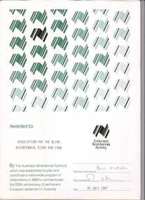
Certificate - Text, Association for the Blind: Bicentennial River Run 1988, 1987
Certificate reads "Awarded to Association for the Blind Bicentennial River Run 1988. By the Australian Bicentennial Authority which was established to plan and coordinate a nationwide program of celebrations in 1988 to commemorate the 200th anniversary of permanent European settlement in Australia" Signed by the Chairman: Victoria Council (illegible) and Executive Director (illegible), dated 30th July 1987. All text on this certificate is located on the bottom half of the document. The top half is populated by a repeated stylised graphic of a map of Australia, in various shades of green and gold. There is also a gold version of the same logo, labelled with "Endorsed Bicentennial Activity" , situated above the official signatures. 1 certificate with Australia imageryassociation for the blind, awards -
 Vision Australia
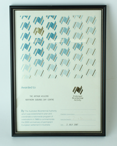
Award - Text, Certificate awarded by the Australian Bicentennial Authority, 2 July 1987
Certificate reads "Awarded to Association for the Arthur Wilkins Northern Suburbs Day Centre. By the Australian Bicentennial Authority which was established to plan and coordinate a nationwide profram of celebrations in 1988 to commemorate the 200th anniversary of permanent European settlement in Australia" Signed by the Executive Director (illegible), dated 2nd July 1987. All text on this certificate is located on the bottom half of the document. 1 x paper certificate from Australian Bicentennial AuthorityThe top half is populated by a repeated stylised graphic of a map of Australia, in various shades of green and gold. There is also a gold version of the same logo, labelled with "Endorsed Bicentennial Activity" , situated above the official signatures. arthur wilkins centre, essendon, association for the blind -
 City of Greater Bendigo - Civic Collection
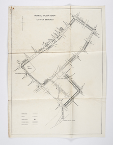
Document - Set of correspondence re Queen Elizabeth tour of Bendigo, Mrs T. R. Mannix, February 8th, 1954
Correspondence between Mrs T. R. Mannix, Swan Hill Wolf Cub Pack master to District Scout Commissioner Mr J. I. Samson for an invitation to be included with the local scout groups in functions to welcome Queen Elizabeth and the Duke of Edinburgh to Bendigo on Friday, the 5th of March 1954. The response from the Commissioner included typed plans of the event and maps of the royal tour through the streets of Bendigo starting and finishing at the train station.Set of correspondence including typed gatefold letter, typed plans for placement of visitors and role of the military and maps of CBD Bendigo and of Upper Reserve.queen elizabeth, duke of edinburgh, boy scout association, mayor clayton, city of greater bendigo royal visits, city of greater bendigo community groups, city of greater bendigo tourism -
 Canterbury History Group
Document - Planning for our future, City of Boroondara, 1/07/2014 12:00:00 AM
City of Boroondara paper describing the approval of the Victorian Government to approve new Residential Zones in some areas of Boroondara. Includes a map of the areas affectedboroondara, city of boroondara, amendment c199, residential development, victorian government, local laws, ross> coral -
 Falls Creek Historical Society
Plan - Leases of part of Falls Creek Tourist Area
Bob (Herman) Hymans (a former member of the Royal Netherlands Navy was born in Bloemendaal, Holland on 30th September 1922. During World War II he fought against the Japanese in the Dutch East Indies (now Indonesia) and was imprisoned in Changi and on the Burma Railway. After gaining qualifications as a Ski Instructor, Bob arrived in Falls Creek in May 1950. Working as an Instructor and Supervisor at Bogong Lodge, Bob decided his future was in accommodation. He was successful in negotiating an indenture for land from the State Electricity Commission (SEC). It took Bob two years to build his Grande Coeur Chalet but, tragically, it was burned down in August 1961. Bob also built the first Chairlift in Australia. This was a single chairlift and the structure was built from wooden electricity poles. He was constantly full of new ideas and proposals for the village. Bob Hymans died on 7th May 2007. This Collection of documents and letters tells the story of Bob’s endeavours to develop Falls Creek into the ski village it is today. This map is significant because it documents boundaries of early leases in Falls Creek Tourist Area.This map is part of Bob Hymans documents. It is a large Surveyor's Plan of a section of the Falls Creek Tourist Area. It is endorsed by J Parker, Chief Surveyor of the State Electricity Commission of Victoria on 27-3-84. It shows streets, lot numbers and measurements. It was a compilation created from existing lease maps. Heading - PART OF FALLS CREEK TOURIST AREA PART OF CROWN ALLOTMENT 1 PARISH OF CARRUNO PART OF CROWN ALLOTMENT 1 PARISH OF DARBALANG COUNTY OF BOGONGmap of falls creek, falls creek leases, falls creek 1980s -
 Falls Creek Historical Society
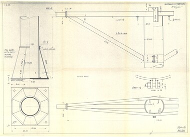
Plan - Diagram of Pylon for New Chairlift
Bob (Herman) Hymans (a former member of the Royal Netherlands Navy was born in Bloemendaal, Holland on 30th September 1922. During World War II he fought against the Japanese in the Dutch East Indies (now Indonesia) and was imprisoned in Changi and on the Burma Railway. After gaining qualifications as a Ski Instructor, Bob arrived in Falls Creek in May 1950. Working as an Instructor and Supervisor at Bogong Lodge, Bob decided his future was in accommodation. He was successful in negotiating an indenture for land from the State Electricity Commission (SEC). It took Bob two years to build his Grande Coeur Chalet but, tragically, it was burned down in August 1961. Bob also built the first Chairlift in Australia. This was a single chairlift and the structure was built from wooden electricity poles. He was constantly full of new ideas and proposals for the village. Bob Hymans died on 7th May 2007. This Collection of documents and letters tells the story of Bob’s endeavours to develop Falls Creek into the ski village it is today. This map is significant because it documents plans being proposed by Bob Hymans for Falls Creek.This diagram is part of Bob Hymans documents. It contains design drawings, measurements and cross sections for one of the pylons for a chairlift proposed by Bob Hymans. The design has been drawn up by Australasian Ropeways. It has been signed by Vladimir Hájek, a Czech engineer who Mr Hymans had consulted on several projects.Top right: AUSTRALASIAN ROPEWAYS with signature V. Hájek Bottom right: 204-01 PYLONmap of falls creek, falls creek leases, falls creek 1980s -
 Falls Creek Historical Society
Plan - Diagram of Turnstile for New Chairlift
Bob (Herman) Hymans (a former member of the Royal Netherlands Navy was born in Bloemendaal, Holland on 30th September 1922. During World War II he fought against the Japanese in the Dutch East Indies (now Indonesia) and was imprisoned in Changi and on the Burma Railway. After gaining qualifications as a Ski Instructor, Bob arrived in Falls Creek in May 1950. Working as an Instructor and Supervisor at Bogong Lodge, Bob decided his future was in accommodation. He was successful in negotiating an indenture for land from the State Electricity Commission (SEC). It took Bob two years to build his Grande Coeur Chalet but, tragically, it was burned down in August 1961. Bob also built the first Chairlift in Australia. This was a single chairlift and the structure was built from wooden electricity poles. He was constantly full of new ideas and proposals for the village. Bob Hymans died on 7th May 2007. This Collection of documents and letters tells the story of Bob’s endeavours to develop Falls Creek into the ski village it is today. This map is significant because it documents plans made by Bob Hymans for Falls CreekThis diagram is part of Bob Hymans documents. It is a detailed plan, including elevation, detail of pivot and the general arrangement views of a turnstile. This is part of overall plans for the construction of a new chairlift at Falls Creek. At bottom of diagrams: PLAN TURNSTILE/ GENERAL ARRANGEMENT Scale 1 1/2" = 1'- 0"map of falls creek, falls creek leases, falls creek 1980s -
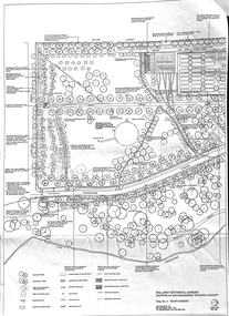 Friends of Ballarat Botanical Gardens History Group
Work on paper - Ballarat Botanical Gardens Master Plan, Final Draft 1995, 1995
This is the "Final Draft" of the Ballarat Botanical Gardens Masterplan in 1995.This document gives some insight into how the Ballarat Botanical Gardens have developed since 1995.There are 6 pages of print and 5 mapsThe City of Ballarat logo is in the centre of p.1.doctor john garner, john garner, john garner collection, friends of ballarat botanical gardens, ballarat botanical gardens, masterplan, gardens, ballarat, drawings -
 Wodonga & District Historical Society Inc
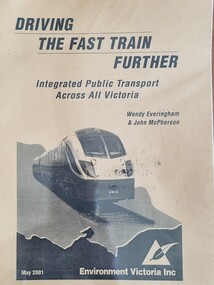
Booklet - Driving the Fast Train Further, Wendy Everingham and John McPherson, May 2001
This document is a response by Environment Victoria to the Fast Train Report. It advocates the establishment of an integrated transport approach in Victoria including the need for a Rural and Regional Planning Strategy to be developed in conjunction with the Metropolitan StrategyA publication of 34 pages produced by Environment Victoria Inc. It has brown cover featuring an image of a locomotive superimposed over an outline map of Victoria. It consists of 36 pages including appendices, references, a map of an Environment Victoria Enhanced Victorian Passenger Rail Network and a map of the Victoria's Regional and Rural Bus service.fiction This document is a response by Environment Victoria to the Fast Train Report. It advocates the establishment of an integrated transport approach in Victoria including the need for a Rural and Regional Planning Strategy to be developed in conjunction with the Metropolitan Strategyrailways environmental impact, victorian railways, environment victoria -
 Wodonga & District Historical Society Inc
Album - Hume Reservoir Australia Album - Plans and Progress Photos - River Murray Water Scheme, Department of Public Works, N.S.W, 1927
This set of photos is from a leather bound album bearing the inscription "HUME RESERVOIR AUSTRALIA" plus 'The Rt. Hon. L. C. M. S. Amery, P. C., M .P.' all inscribed in gold. It was presented to The Rt. Hon. L. C. M. S. Amery, P. C., M. P, Secretary of State for Dominion Affairs on the occasion of his visit to the Hume Reservoir on 2nd November 1927. This album is of local and national significance as it documents the planning and development of the Hume Reservoir up to 1927. It was the largest water reservoir in the British Empire. The album records the pioneering engineering work that went into its construction.1. Locality Plan and Plan of Dam. The dam is about ten miles by road upstream from Albury and about three-quarters of a mile below the confluence of the Mitta Mitta River and the Murray River. Its main features consist of a concrete portion across the bed of the river with earth embankment at both ends. The foundations throughout are on hard granite, found at an average depth of about 40 feet below the surface, the centre line being located to take advantage of the most favourable rock levels.Heading on page "WORKS UNDER RIVER MURRAY WATERS AGREEMENT/HUME RESERVOIR" Beneath top diagram "FIG. 1. ELEVATION" Beneath second diagram "FIG. 2. PLAN" On map "LOCALITY PLAN"hume reservoir australia, river murray waters scheme, hume weir diagrams, hume weir location -
 Wodonga & District Historical Society Inc
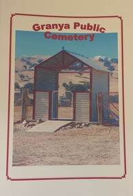
Booklet - Granya Public Cemetery
This booklet was compiled by the Granya Heritage group. It contains records of people buried at the Granya Public Cemetery between 1880 and 2003. The booklet contains maps of the plots in both the Protestant and Catholic sections of the cemetery. Where available information provided includes Surname, Given Name, Year of Death, Age, Parents , Registration No., Denomination and Cause of Death.A booklet containing a plan of the Granya Public Cemetery and a listing of the people buried there between 1880 and 2003. The cover features a colour photograph of the gateway to the cemetery.non-fictionThis booklet was compiled by the Granya Heritage group. It contains records of people buried at the Granya Public Cemetery between 1880 and 2003. The booklet contains maps of the plots in both the Protestant and Catholic sections of the cemetery. Where available information provided includes Surname, Given Name, Year of Death, Age, Parents , Registration No., Denomination and Cause of Death.granya public cemetery, cemetery records -
 Wodonga & District Historical Society Inc
Map - Boorgunyah - "The Town that never was"
At the height of the river trade, there was a town surveyed and laid out, and streets were named. This town was to house the workers at the river port of Red Bank when the paddle steamers plied the Murray River as far as Albury, carrying produce such as wool and wheat to the various towns along the river in the 1800s. As the river trade died away, this town never went ahead – one might say, “The town that never was.” A lone gum tree stands on the site today.This item is significant because it documents plans which were made for the early development of Wodonga.A black an white map depicting the proposed location of the township. The map is based on a sketch and is not to scale,early wodonga, boorgunyah - "the town that never was", wodonga heritage -
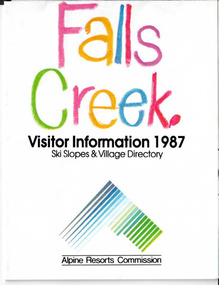 Falls Creek Historical Society
Booklet - Brochure - Falls Creek Visitor Information 1987
Part of an annual marketing campaign, this booklet was designed to provide information for planning a holiday at Falls Creek for the winter of 1987. It includes extensive details about activities, facilities and accommodation in the Village as well as contact information to make necessary bookings.This item is important because it documents seasonal activities at Falls Creek Alpine ResortFold out information guide for Falls Creek winter holidays 1987 including images, text and maps,falls creek marketing, falls creek winter programs, falls creek village -
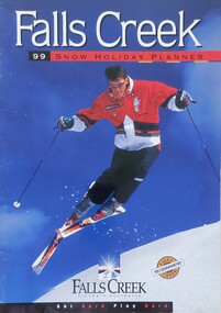 Falls Creek Historical Society
Magazine - Falls Creek 99 Snow Holiday Planner
Part of an annual marketing campaign, this booklet was designed to provide information for planning a holiday at Falls Creek for the winter of 1999. It includes details about activities, facilities and accommodation in the Village as well as contact information to make necessary bookings.This item is important as it documents seasonal activities at Falls Creek Alpine ResortA booklet containing detailed information and images including a map, prices and booking details.falls creek, winter sport, 1990s, falls creek marketing -
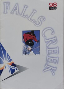 Falls Creek Historical Society
Magazine - Falls Creek 98 Holiday Planner
Part of an annual marketing campaign, this booklet was designed to provide information for planning a holiday at Falls Creek for the winter of 1998. It includes details about activities, facilities and accommodation in the Village as well as contact information to make necessary bookings.This item is important as it documents seasonal activities at Falls Creek Alpine ResortA booklet containing detailed information and images including a map, prices and booking details.falls creek, victoria, winter sport, falls creek marketing -
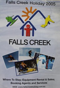 Falls Creek Historical Society
Booklet - Falls Creek Holiday 2005
Part of an annual marketing campaign, this booklet was designed to provide information for planning a holiday at Falls Creek for the winter of 2005. It includes details about activities, facilities and accommodation in the Village as well as maps and contact information to make necessary bookings.This item is important as it documents seasonal activities at Falls Creek Alpine Resort An A4 sized marketing booklet, including images and advertising information printed in colour and black and white.falls creek marketing, falls creek 2005, falls creek accommodation -
 Whitehorse Historical Society Inc.
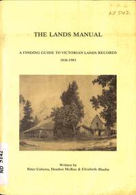
Manual - Government (Lands Dept), Royal Historical Society of Victoria, The Lands Manual - A Finding Guide to Victorian Land Records 1836 - 1983, March 1989
The manual documents the archives of the Department of Crown Lands and Survey (Lands Department) between 1836 to 1983 and explains how they can be used for historical research.The manual documents the archives of the Department of Crown Lands and Survey (Lands Department) and explains how they can be used for historical research.The manual documents the archives of the Department of Crown Lands and Survey (Lands Department) between 1836 to 1983 and explains how they can be used for historical research.crown lands, victoria. department of crown lands and survey -
 Bacchus Marsh & District Historical Society
Map, Plan of part of the road district of Bacchus Marsh circa 1856-1862
Local government in much of Victoria including the Bacchus Marsh area began with the formation of 'local committees'. These local committees could make representations to a Central Road Board regarding plans for road construction. Road construction and maintenance were seen as the essential tasks of these early local government authorities. By 1856 the local committee in Bacchus Marsh was constituted as the Bacchus Marsh Road District. This entity continued until 1862 when the name changed to the Bacchus Marsh and Maddingley Road District. This new entity lasted until 1871 when the local government authority in accordance with new statewide legislation became known as the Shire of Bacchus Marsh. The title of this plan being a plan of 'a portion of the road district of Bacchus Marsh' suggests that the plan was produced sometime between 1856 and 1862. The main purpose of this map was to shown the irrigable land in the district and the sources from which water for irrigation could be drawn. Bacchus Marsh was an early irrigation district in Victoria. Irrigation trusts were formed in the 1880s and 1890s to manage irrigation districts. But this was the culmination of many years of earlier attempts to construct irrigation systems in the Bacchus Marsh area and create a system to manage irrigation more broadly. This map dating from around 1856-1862 is an important cartographic document which provides evidence of how the early planning for irrigation was developing in the Bacchus Marsh region.A single page paper map showing a plan of part of the road district of Bacchus Marsh. The map is pasted into a bound volume containing 76 maps or plans in total. High resolution digital image stored on BMDHS computer network. bacchus marsh victoria maps, bacchus marsh road district, local government, road districts, irrigation -
 Tatura Irrigation & Wartime Camps Museum
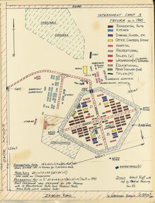
Map - Sketch Plan, Internment Camp 3 Tatura as in 1945, January 1992
Plan drawn from documents and memory by former internees Helmut Ruff and Manfred Haering. Sketch plan of Camp 3 Tatura layout as in 1945. Camp contained members of Palestine, Singapore/Straits Settlement & New Guinea Groups.Copy of black ink and coloured A3 plan mounted on hardboard showing layout of buildings and perimeter fencing of camp 3 Tatura. Original hand drawn.palestine group, singapore group, new guinea group, helmut ruff, manfred haering, camp 3 layout -
 Greensborough Historical Society
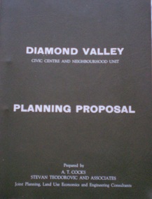
Document - Planning Document, Diamond Valley Civic Centre and Neighbourhood Unit: Planning Proposal, 1960s
This document proposes the change of land use from farming and quarrying to residential. This also includes the proposal for a Civic Centre in the (then) Shire of Diamond Valley. The plans listed in the 'Schedule of Plans' on last page are missing.Includes proposal for the Aqueduct to be converted to an underground system. Includes statistics relating to population increase. Dark brown plastic folder. 23 foolscap-size pages. Maps, Application for Permits to subdivide land in the Greensborough area.partington family, mitchell family, whittingham family, albion reid, diamond valley civic centre, shire of diamond valley -
 Bendigo Military Museum
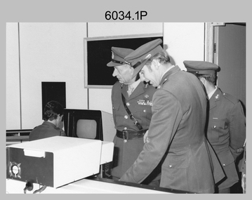
Photograph - Visit by the Chief of the General Staff to the Army Survey Regiment, Fortuna, Bendigo, 1979
This is a set of 14 photographs of a visit to the Army Survey Regiment, Fortuna, Bendigo on the 5th of June 1979 by the Chief of the General Staff (CGS) Lieutenant General Sir Donald Dunstan AC, KBE, CB. He was accompanied by his wife. They were escorted through the production areas of the Army Survey Regiment by the CO LTCOL Bob Skitch. Lieutenant General Sir Donald Dunstan AC, KBE, CB was an esteemed Australian Army officer, who was CGS from 1977 to 1982. Upon retirement from the Army in 1982, he was appointed to the position of Governor of South Australia from 1982 to 1991. LTCOL Bob Skitch was the CO of the Army Svy Rgt from 1976 to 1980. Also featuring in these photos is MAJ Peter Eddy, who was the OC of Air Survey Squadron. He was later promoted to LTCOL and was CO of the Army Svy Rgt from 1981 to 1982. See item 6035.9P for photos of the CGS’s presentation of the Defence Force Service Medal to four recipients.This is a set of 14 photographs of a visit by the Chief of the General Staff to the Army Survey Regiment Fortuna, Bendigo on the 5th of June 1979. The photographs were printed on photographic paper and are part of the Army Survey Regiment’s Collection. They were scanned at 300 dpi. .1) - Photo, black and white, 1979. Tour of Air Survey Squadron. L to R: unidentified, LTGEN General Sir Donald Dunstan AC, KBE, CB; OC MAJ Peter Eddy, unidentified. .2) - Photo, black and white, 1979. Tour of Air Survey Squadron. LTGEN General Sir Donald Dunstan AC, KBE, CB; views 3D stereoscopic aerial photography on a Zeiss (Jena) Stecometer. OC MAJ Peter Eddy is on his right. .3) - Photo, black and white, 1979. Tour of Air Survey Squadron. L to R: unidentified, CO LTCOL Bob Skitch, OC MAJ Peter Eddy, LTGEN General Sir Donald Dunstan AC, KBE CB viewing an aerial photograph. WO1 Brian Mead and others are operating a Wild PUG4 point transfer device. .4) - Photo, black and white, 1979. Enlargement of photo .3). Tour of Air Survey Squadron. L to R: unidentified, CO LTCOL Bob Skitch, OC MAJ Peter Eddy, LTGEN General Sir Donald Dunstan AC, KBE CB viewing an aerial photograph. .5) - Photo, black and white, 1979. Tour of Air Survey Squadron. LTGEN General Sir Donald Dunstan AC, KBE, CB; and unidentified technician view 3D stereoscopic aerial photography on a Wild B8 stereo plotter. .6) - Photo, black and white, 1979. Tour of Air Survey Squadron. L to R: OC MAJ Peter Eddy LTGEN General Sir Donald Dunstan AC, KBE CB; CO LTCOL Bob Skitch, view the output of a verification plot on an AUTOMAP 1 Gerber 1442 drum plotter. .7) - Photo, black and white, 1979. Tour of Air Survey Squadron. L to R: CO LTCOL Bob Skitch, unidentified aide de camp officer, LTGEN General Sir Donald Dunstan AC, KBE CB; OC MAJ Peter Eddy discuss aero triangulation planning documents. CAPT Don Maskew in background. .8) - Photo, black and white, 1979. Tour of Cartographic Squadron. L to R: CPL Dennis Learmonth, acting OC CAPT Bob Roche, CAPT Eddy Schulze, LTGEN General Sir Donald Dunstan AC, KBE CB; SSGT John ‘JB’ Barrie discuss cartographic map compilation procedures .9) - Photo, black and white, 1979. Tour of Cartographic Squadron. L to R: Tech WO WO1 Roger Rix, acting OC CAPT Bob Roche, CAPT Eddy Schulze, unidentified visitor, Mrs Dunstan with examples of map products. .10) - Photo, black and white, 1979. Tour of Cartographic Squadron. L to R: CPL Terry Danger, CO LTCOL Bob Skitch, LTGEN General Sir Donald Dunstan AC, KBE CB; discuss terrain embossing (hill shading) procedures. .11) - Photo, black and white, 1979. Tour of Cartographic Squadron. L to R: CO LTCOL Bob Skitch, LTGEN General Sir Donald Dunstan AC, KBE CB; acting OC CAPT Bob Roche, SSGT Dick Manley, CAPT Don Maskew and CAPT Steve Cooper in background. SPR Cheryl Lofthouse is retouching blemishes on a map separation film negative. .12) - Photo, black and white, 1979. Tour of Lithographic Squadron. L to R: CAPT Stan Vote, unidentified aide de camp officer, CO LTCOL Bob Skitch, LTGEN General Sir Donald Dunstan AC, KBE CB; MAJ Sam Schwartz EXCH-US, LT John Harrison discuss bulk map printing processes with an Ultra-MAN-III Printing Press. .13) - Photo, black and white, 1979. Officers Mess L to R: LTGEN General Sir Donald Dunstan AC, KBE CB; with CO LTCOL Bob Skitch. .14) - Photo, black and white, 1979. Officers Mess L to R: MAJ Peter Eddy, LTGEN General Sir Donald Dunstan AC, KBE CB..1P to .14P – no annotationsroyal australian survey corps, rasvy, army survey regiment, army svy regt, fortuna, asr -
 Ringwood and District Historical Society
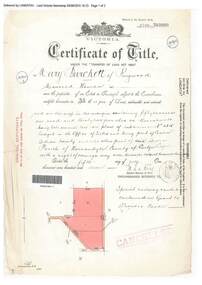
Document, Certificate of Title - Mary Burchett, Lilydale Road, Ringwood - part of Crown Section 20, Parish of Warrandyte, County of Evelyn - 5th July, 1911
A4 copies of Landata Victoria Historical Search documents - Vol 3520 Fol 703990.Mary Burchett of Ringwood, Married Woman, is now the proprietor of an Estate in Fee-simple subject to the Encumbrances notified hereunder ... 50 acres 1 rood 32 perches or thereabouts, being lots 1 and 10 on plan of subdivision no.4315. Subdivision map includes un-named roads - western side is Wonga Road (later Warranwood Road), and eastern side is Grandview Grove (later Bemboka Road), both north of Plymouth Road, Ringwood, Vic. Title transferred to Theodore Hartley Burchett, 27th July, 1911. Encumbrance comment "Special railway condition contained in Grant to Francis Cooke." -
 Heidelberg Golf Club
Book, Melbourne Parks and Waterways, Lower Plenty River concept plan: Maroondah Pipe Track to Yarra River, 1994
Lower Plenty River concept plan: Maroondah Pipe Track to Yarra River. Includes suggestion of Plenty River Trail along the west boundary of the Heidelberg Golf Club.66 p., illus., colour map. Also, Draft copy of document.plenty river trail, lower plenty river, heidelberg golf club, mmbw, melbourne parks and waterways