Showing 215 items matching "dunes"
-
 Lakes Entrance Historical Society
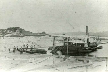
Photograph - Wombat, 1885c
The dredge 'Wombat' owned by John Carpenter, contractor for stage one of cutting the entrance from the lake through to ocean - Bass Strait. Photo shows channel partly dredged and men on work platform in front of dredge.Black and white photograph showing bucket dredge Wombat removing sand from between piers. Dunes on western side on left, lakes in background, hills of Kalimna and Nungurner in distance. Work platform in front of dredge with workers. Lakes Entrance Victoria waterways, public works, dredging -
 Lakes Entrance Historical Society
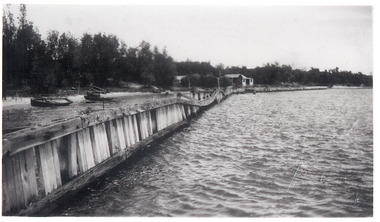
Photograph - Hopetoun Channel, 1946
Black and white photograph showing walings along shoreline west of entrance piers and Schnapper Cotttage further along. Dense vegetation on dunes, several small boats on beach behind walings, Hopetoun channel right foreground. Lakes Entrance Victoriahouses, waterfront -
 Bendigo Historical Society Inc.
Book - BIT PAPERS, 1971
B.I.T. Papers Summer 1970-71, articles by various contributors, contents include, Building the Melbourne-Bendigo Railway, Engineering in Colonial Times, Source-Bordering Sand Dunes along the Loddon River & others, 66 pages with black and white photographs and maps..history, australian -
 Lakes Entrance Historical Society
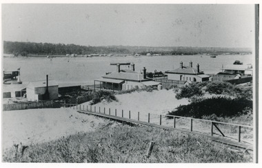
Photograph - Carpentertown, 1900c
Also four other black and white copies, one size 12 x 18 cm, two size 9 x 14 cm, and one size 10 x 15 cm, one of which was purchased from Helen ClothierBlack and white photograph showing buildings on dunes, and township of Lakes Entrance across lake, Cunninghame Arm. Buildings from left are school, harbour masters house, harbour engineer's house. Boardwalk in foreground. Kalimna Hill in background. Lakes Entrance Victoriawaterways, vegetation, topography, township, historic buildings -
 Lakes Entrance Historical Society
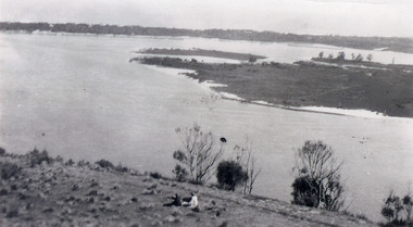
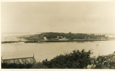
Photograph - Snake Island, 1930c
Black and white photograph, showing eastern end of Rigby Island, Snake Island, at Lakes Entrance, Victoria. Reeves Channel below foreground hill, Hopetoun Channel between dunes and islands with fish pens in distance. Two people sitting on hill in foreground.islands, waterways, topography, room display -
 Lakes Entrance Historical Society
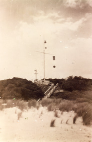
Photograph - Flagstaff, Flagstaff Lakes Entrance, 1910c
Navigation baskets were used to guide boats in and out of Lakes Entrance Sepia photograph showing flagstaff with navigation baskets on dunes at entrance to Gippsland Lakes. Two smaller baskets above yardarm, two larger baskets below yardarm. Lakes Entrance Victoria. Also black and white copy 20 x 13.5 cmnavigation, boardwalk, boats and boating, ships and shipping -
 Phillip Island Conservation Society Inc.
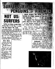
Work on paper - Photocopy of newspaper cutting, The Express, "SURFERS' FIRES KILL/ PENGUINS - FIREMEN//NOT US:/SURFERS"
Written during the 1960s when surfing was burgeoning across Australia’s coast and Phillip Island surf beaches had become extremely popular, few management strategies were in place to control interaction of the public with the delicate flora and fauna of the coastal environments. There were few good access tracks, car parks, bins, toilets etc at coastal/surfing hotspots around the Phillip Island coast. A number of management issues occurred with the influx of surfers. These included dune erosion caused by surfers climbing dunes to see the surf before going on the beach; informal parking on wildlife habitat; numerous access paths from wherever cars were parked down to the beach cutting through habitat; illegal camping on foreshores; illegal lighting of fires on beach and in dunes; surfers’ dogs let out of the car while surfers were out on the water. The dogs were uncontrolled. Certainly some surfers behaved responsibly, as is almost invariably the case these days. However, in that era of this article few people understood the delicate nature of the coastal environment and that it need to be protected through public education, infrastructure and enforcement of regulations. As now, most rural Fire services were run by dedicated volunteers who faced many challenges in their roles as Country Fire Authority firefighters. However, it was not uncommon for visitors and locals to also assist with fire-fighting efforts.The article is significant in containing quotes from both sides of the discussion who were directly involved in coastal fire incidents on Phillip Island in the 1960s. It also indicates the large number of surfers visiting Phillip Island beaches, the volunteer nature of the firefighting service and the extra challenges they faced on Phillip Island as a visitor destination. The anonymous university student surfer who is quoted, also describes possible causes of the fires, methods he and his fellow surfers used to extinguish the fires and raise the alarm, and the way they assisted the volunteer firefighters . The reference to him breaking into one of the Summerland housing estate holiday houses is also significant because that housing estate was purchased over 2 decades by successive Victorian governments to remove management issues caused to the wildlife habitat on Summerland Peninsula.Photocopy of newspaper cuttings including 2 related articles. Five columns of black text on white paper with one poorly reproduced photo bottom rightphillip island, cat bay, country fire authority, artie murdoch, alf towns, frank dixon, barry thompson, newhaven-san remo rural fire brigade, penguin parade, cowrie beach, surfers, coastal fires -
 Lakes Entrance Historical Society
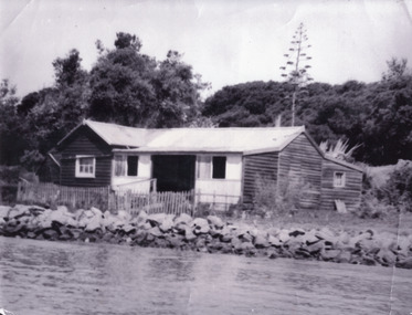
Photograph - Schnapper Cottage, 1944
Black and white photograph showing, Schnapper cottage on western side of entrance. Dark weatherboards, front partially screened in, picket fence along front, rocks along shoreline, thick vegetation on dunes, tall century plant at rear of house. Lakes Entrance Victoria waterfront, historic buildings -
 Lakes Entrance Historical Society
Photograph - The Entrance, 1910c
also copies|Two black and white 8.5 x 14|Two black and white 16 x 25Sepia photograph showing view of entrance to Gippsland Lakes from ocean- Bass Strait, looking west towards Western Pier and dunes. Foreground on left shows gable roof of rocket shed and shipwreck bell on white post on right. Lakes Entrance Victoriawaterways, sandbar, rocket shed -
 Lakes Entrance Historical Society
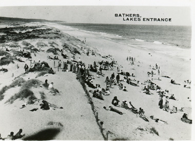
Postcard - Ocean Beach, 1950c
2 other copiesBlack and white small format postcard of bathers at the ocean beach. It shows a crowd of people on the sand dunes, remains of a brush fence, Southern Ocean and Red Bluff in distance. Taken from original tower, built for Royal Lifesaving Club. Lakes Entrance VictoriaBathers, Lakes Entrance topography, people, beaches, recreation -
 Lakes Entrance Historical Society
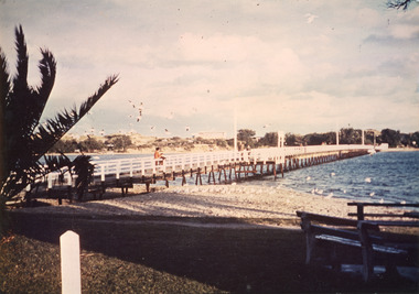
Photograph - Footbridge, Tambo Shire, 1985c
Colored photograph of footbridge over the Cunninghame Arm. It shows a flock of seagulls on the northern shore beside the approaches to the bridge, which has white painted railings, surf lifesaving club house on dunes in distance, several groups of people on footbridge. Lakes Entrance Victoriawaterways, bridges, tourism -
 Lakes Entrance Historical Society
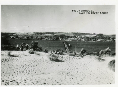
Postcard - Township, 1950c
2 copies 6 x 9Black and white small format postcard of footbridge over Cunninghame Arm. It shows people on bare sand dunes in foreground boat moored beside bridge, motor vehicles parked along retaining wall on North shore with town buildings in background. Lakes Entrance VictoriaFootbridge Lakes Entrancebridges, waterways, township, people -
 Lakes Entrance Historical Society
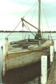
Photograph, Glenice Soderlund, Lady Harriet barge, Lakes Entrance Victoria, 1/06/1989 12:00:00 AM
Colour photograph showing Lady Harriet barge moored at wharf in Cunninghame Arm mast and rigging intact. Bullock Island and sand dunes in background Lakes Entrance Victoria. Also an enlarged colour lamenated photograph almost identical 04673.1 29 x 19.5 cmbarges, boats and boating -
 Lakes Entrance Historical Society
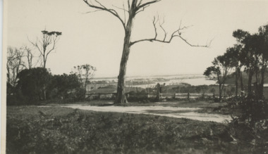
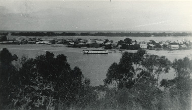
Postcard, Lakes Entrance 1930, 1930 c
Black and white postcard showing view from top of hill north of Lakes Entrance shows North Arm with west end of town Cunninghame Arm and sand dunes in distance. Track in foreground Myers Street known as Allens Hill in 1930 Lakes Entrance Victoriatownship, waterways, roads and streets -
 Phillip Island and District Historical Society Inc.
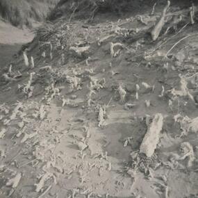
Photograph
... dunes ...One of a collection of over 400 photographs in an album commenced in 1960 and presented to the Phillip Island & Westernport Historical Society by the Shire of Phillip IslandPhotograph of calcareous moulds formed by early forms of vegetation and subsequent action of wind and sand.local history, photography, calcareous moulds, black & white photograph, coastline, dunes, john jenner, bryant west -
 Glenelg Shire Council Cultural Collection
Photograph - Photograph - Bridgewater Hotel, Victoria, n.d
Black and white photo of the Bridgewater Hotel, front view. Double storey building, front verandah, tin roof, chimney each side of building. Three windows on first floor, window either side of door, ground floors, picket fence with gate; sand dunes behind.Back: 'BRIDGEWATER HOTEL' -printed in capitals, blue biro -
 Lakes Entrance Historical Society
Photograph - Carpentertown, 1920c
Copied from a copy in possession of J WhadcoatBlack and white photograph showing view of seven cottages on dunes. View of several boats at jetties and on slipway, white shed on New Works wharf, Cunninghame Arm in front of cottages, part of Bullock Island showing some vegetation and one telegraph pole. Lakes Entrance Victoriawaterways, islands, settlement -
 Lakes Entrance Historical Society
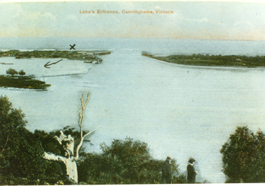
Postcard - The Entrance, 1900c
Also copy tinted postcard 10 x 15Coloured post card of the man made entrance through the sand dunes, taken from Jemmys Point. It shows the works and settlement at the entrance, Bullock Island and groynes to direct flow of lake waters towards entrance. Two men standing on Jemmys Point. Lakes Entrance VictoriaLakes Entrance, Cunninghame, Victoriaislands, waterways, topography -
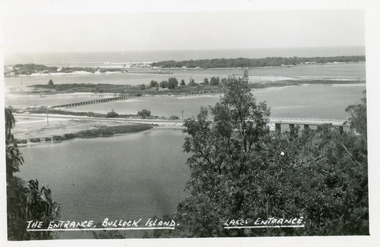 Lakes Entrance Historical Society
Postcard - Bullock Island, The Lakes Studio, 1920c
One black and white copy 17 x 25Black and white postcard showing North Arm Bridge, Bullock Island and foot bridge northern end of piers at entrance to Bass Strait and sand dunes. Left foreground shows power pole and water bore and telephone poles along Princes Highway Lakes Entrance Victoria.The Entrance, Bullock Island, Lakes Entranceislands, bridges, waterways, topography -
 Lakes Entrance Historical Society
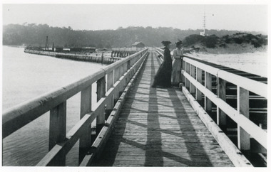
Photograph - Eastern Pier, Caire Nicholas John, 1905c
2 copies with inscription below|1 x 9 x 14|1 x 12.5 x 17.5|View of Flagstaff and Rocket Shed from the Eastern Pier of Lakes Entrance, this was the New Works, (photograph 1906c - A Maclachlan)|Enlargement black and white 20.5 x 28|Also copy in Caire P01049Black and white photograph showing two ladies on Eastern Pier, view of beach, dune and flagstaff on right, entrance and northern end of pier and works buildings on left, Kalimna escarpment in background. Lakes Entrance Victoria. Plus another photo of Eastern Pier looking toward the Entrance waterways, piers, boardwalk -
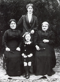 Lakes Entrance Historical Society
Photograph - Lee Family, 1914 c
Black and white photograph of women members of the Lee family at the family home The Hummocks on the sand dunes south shore of Cunninghame Arm. Shown are Mrs Kathryn Delahunty, Mrs Cathryn Lee nee Delahunty, Mrs Emily Carstairs nee Lee and Ina Carstairs Lakes Entrance Victoriagenealogy -
 Lakes Entrance Historical Society
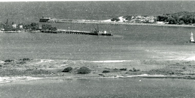
Photograph - The Entrance, 1920c
Copied from photograph in possession of J WhadcoatBlack and white photograph showing stone piers at entrance to Gippsland Lakes from ocean - Bass Strait. Eastern pier on left, dune and western pier on right. Cranes and some work sheds on left. Navigation light on tip of Bullock Island on extreme right. Lakes Entrance Victoriajetties, waterways, topography, township -
 Lakes Entrance Historical Society
Photograph - Lakes Entrance, 1945 c
The Hulk of the Baang Yarnda on the North Arm foreshore. (Note in album)Black and white photograph showing view from Kalimna cliff overlooking North Arm and township, Cunninghame Arm and sand dunes out to Bass Strait. Hulk of old Baang Yarnda moored in North Arm, towed there in 1939 and left to rot. Thick vegetation in foreground. Lakes Entrance Victoria.township, waterways -
 National Vietnam Veterans Museum (NVVM)
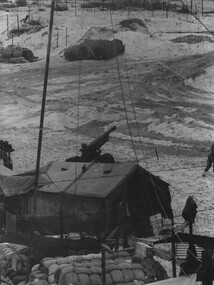
Photograph, Gibbons, Denis, Quiet Time
Denis Gibbons (1937 – 2011) Trained with the Australian Army, before travelling to Vietnam in January 1966, Denis stayed with the 1st Australian Task Force in Nui Dat working as a photographer. For almost five years Gibbons toured with nine Australian infantry battalions, posting compelling war images from within many combat zones before being flown out in late November 1970 after sustaining injuries. The images held within the National Vietnam Veterans Museum make up the Gibbons Collection. A black and white photograph of a quiet time, in a gun detachment area at an Australian Fire Support Base, in the sand dunes, on the coast, South East of the 1st Australian Task Force Base at Nui Dat, Phuoc Tuy Province, South Vietnam. The Battery was supporting Infantry in the area (circa June 1970).photograph, fire support base, 1st atf base, nui dat, phuoc tuy province, infantry, gibbons collection catalogue, photographer, vietnam war, denis gibbons, 105mm howitzer, nui thai vai mountains -
 Lakes Entrance Historical Society
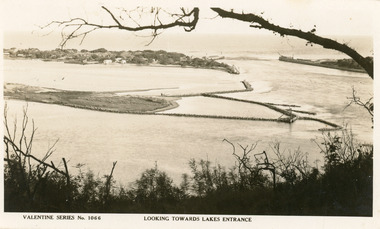
Postcard - Bullock Island
Black and white postcard of west end of Bullock Island, showing rock groynes around island, wooden entrance piers in entrance to Gippsland Lakes from Bass Strait, sand dunes showing New Works houses and sheds. A tree branch across top and foreground shrubbery. Lakes Entrance VictoriaLooking towards Lakes Entrance (on front)islands, waterways, room display -
 Flagstaff Hill Maritime Museum and Village
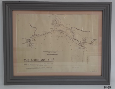
Document - Location Chart, The Mahogany Ship, 2007
This chart shows a possible site for the fabled wreck called the 'Mahogany Ship'. Flagstaff Hill’s collection includes other objects that some say could be relics from this Ancient Wreck, (also called the Gold Ship, or the Ancient Vessel). The chart shows the coordinates for the Summits of Griffith Island and of Middle Island. It also has the depths of the sea at various intervals and shows the shore and sand dunes, lighthouses and other reference points. The mystery of the Mahogany Ship began in 1836 when two shipwrecked sealers discovered the remains of an “ancient vessel” in the sand dunes about four miles west of Warrnambool. Since the last recorded sightings in the 1880’s the true origin of the Mahogany Ship has remained one of Australia’s most famous historical mysteries or fables. One of the more recent theories is that the vessel was one of the Portuguese ships exploring the Australian coast in 1522. For over one hundred years searchers have attempted to locate and identify the wreck. The search continues for the tangible evidence which will once and for all establish the Mahogany Ship’s place in Australia’s History.The chart represents the worldwide interest in locating the wreck of the Mahogany Ship. Locating the actual wreck or proving the existence of a Portuguese ship's wreck could change the history of the discovery of Australia. A Mahogany Ship committee was formed to gather and research information about the discovery of the wrecked ship. A large amount of money was offered as a prize for finding the wreck or parts of it. People have written books, painted images, made videos and told tales of the ship but it continues to remain a mystery or even a fable. The chart is significant for its possible link to one of Victoria’s and Australia’s maritime mysteries, the Mahogany Ship (also known as the Ancient Wreck). It is one of very few known relics that could give evidence of the existence and history of the vessel. It is listed on the Victorian Heritage Register S438 as it is one of Victoria’s oldest recorded shipwrecks. The identity of the vessel has the potential to change Australia’s history.A chart in a wooden frame, behind glass. The chart shows the approximate position of the mystery Ancient Wreck, later called the "Mahogany Ship". The chart is a copy and is based on the Admiralty Chart by Lieut. Stanley, dated 1872. Lower left: "THE MAHOGANY SHIP" "LOCALITY PLAN, ENLARGED FROM LIEUT. STANLEY'S ADMIRALTY CHART 1872" "APPROXIMATE POSITION OF WRECK MARKED [symbol of a Portuguese cross]" Other labels on chart: "BELFAST" "PORT FIARY" "GRIFFITHS I" "RIVER MOYNE" "RIVER MERRI" "ARMSTRONG BAY" " GORMANS LANE" "TOWER HILL" "KOROIT" "HELEN ROCK" "WARRNAMBOOL" "LADY BAY" "MIDDLE I" "LIGHT HO." Lower right: "G 410 B" Label on the back; "This chart presented to the Mahogany Ship Committee and Flagstaff Hill by Avis Quarrell, April 2007"warrnambool, shipwrecked coast, flagstaff hill maritime museum, shipwreck coast, mahogany ship, ancient vessel, ancient wreck, portuguese ship, coastal reserve, fabled wreck, gold ship, griffiths island, belfast (now port fairy), koroit, location plan, leuit. stanley, admiralty chart 1872, tower hill, merri river, moyne river, middle island, helen rock, armstrong bay, griffiths land -
 Lakes Entrance Historical Society
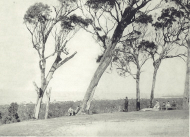
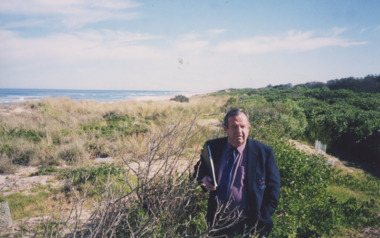
Photograph - Roadknights Merrangbaur property Lakes Entrance Victoria, J Brookes, 1889
Black and white photograph taken from Roadknights Merrangbaur property looking towards the natural entrance, seven people sitting or standing on brow of hill Lakes Entrance Victoria. Also a colour photograph taken from Merrangbaur hill of warm holes and dunes and ocean approximate site of original entrance taken in 1995 historic site, topography, ocean -
 Lakes Entrance Historical Society
Photograph - Golf Club Lakes Entrance Victoria, Lakes Entrance Tidy Town Committee, 2000 c
Greens which shows view across Warm Holes to Golf Club No 1 green adjacent to Eastern BeachColour photograph showing Brian Klemm of Keep Australia Beautiful Council with Margaret Daly and Trish Haberfield of Tidy Town Committee with John Stapleton Robert Blackham Tony McDonough Barry McKenzie and Trevor McCubbin of LE Golf Club inspecting stabilisation work on dunes beside greens Lakes Entrance Victoria people, golf club, sand dunes, warm holes -
4th/19th Prince of Wales's Light Horse Regiment Unit History Room
Field Sketch, From General Chaytor's HQ After the battle of Bir El Abd, c 1917
A field sketch by Sgt Otho Hewett looking North toward Bir El Abd (a well near Arish). The country depicted is a vast area of sand dunes, with the only named features being the Canterbury MR Graves, Bir El Abd (a well), graves, Hod el Zawara and Old Turk telegraph line.field sketch, bir el abd -
 Lakes Entrance Historical Society
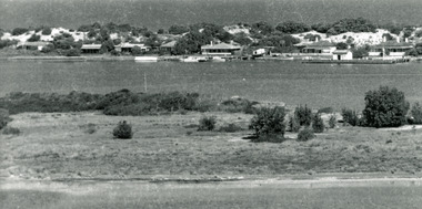
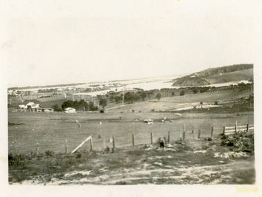
Photograph - Butcher's Paddock, Hanlon, Vera, 1940c
Historic home at 90 Captenter St 'Corrumbene' is pictured on right hand side of photograph. Godsell's house opposite on Western side of North ArmBlack and white photograph showing view of lower reaches of North Arm, part of town, Cunninghame Arm and sand dunes in background, and North Arm on right. Photo taken from Allens Hill, Myer St, vacant paddocks in foreground, known as Butcher's Paddock, slaughterhouse and buildings in mid view. Lakes Entrance Victoriatownship, waterways, animals