Showing 200 items
matching east europe
-
 Ballarat RSL Sub-Branch Inc.
Poster
... Side 1 = Maps - World; Western Europe; The Far East...; Western Europe; The Far East; Mediterranean Area Side 2 ...Side 1 = Maps - World; Western Europe; The Far East; Mediterranean Area Side 2 = Decorations for Valour; Ranks of the Services; Battle Honours and Colour Patches of the AIFliterature, ballarat rsl, ballarat -
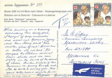 Melbourne Legacy
Postcard - Document, postcard
A postcard to the Comradeship Committee when a Legatee was travelling in Austria. "Bozen mit Blick each Osten" which translates as "Bolzano with view to the east". It is addressed to Mr H Caffrey, Chairman Comradeship at Melbourne Legacy. It is not dated and is signed Brian Lucky Luscombe. It says: "While lunching on a balcony overlooking this lovely place, I thought of soup, sandwiches and scones and Melbourne Legacy. And then Mary said "have another glass of red". At 6000 lire a bottle it's not too bad. We escaped the Italian airline/train strike and are now safely in the land of the Sound of Music. Another 5 weeks of this summer in sunny Europe and I'll be back to annoy you. And you'd better have a new job for me. Regards. Brian Lucky Luscombe.A record of a Legatee travelling and relating experiences back to his comrades in Melbourne.Colour postcard from Austria.Printed "Bozen mit Blick each Osten". Two Austrian postages stamps and an Airmail sticker. Handwritten text in blue pen.comradeship, legatee -
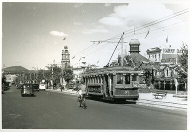 Ballarat Tramway Museum
Photograph - Decorated tram Ballarat 23 in Sturt St, 1938
Photograph shows decorated tram No. 23, eastbound between Dawson and Doveton Streets. The tram was decorated for the 100 years of European settlement (1938) in the Ballarat district. The Queen Alexandra bandstand and buildings in the background have been decorated as well. The street decoration just in front of the tram, was recycled from an earlier Melbourne celebration event. A young man is riding a bicycle alongside the tram.Yields information about the decoration of Sturt St and tram 23 for the 100 years of European settlement (1938).Black and white print of decorated tram 23 in Sturt St, east bound passing the Queen Alexandra Bandstand.ballarat, sturt st, trams, tram 23, decorated trams, queen alexandra bandstand, celebrations. -
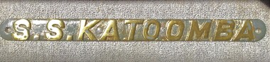 Queenscliffe Maritime Museum
Plaque - Name Plate, 'Katoomba'
McIlwraith McEacharn Line Pty.Ltd., reg. Melbourne. 1918: Commandeered as a troopship. 1919: Returned to owners. 1920: Resumed Australian coastal service. 1941: Commandeered as a troopship. 1942 Aug 4: Fired upon in the Great Australian Bight (WA) by a Japanese submarine. 1946: Returned to owners & sold to Compania Maritima del Este, reg. Panama. Refitted at Genoa and sailed under Greek Line flag. 1947: Chartered to French Line for Caribbean service. 1949: Refitted at Genoa & placed on Europe-Canada run. 1954: Neptunia Shipping Co. 1957: Laid up at Bremerhaven. 1958: Laid up at Piraeus. 1959 Sept.29: Arrived at Nagasaki, Japan having been sold to shipbreakers.Served with SS Duntroon leaving Melbourne on 12 February 1942, to join convoy MS5 to Colombo escorted by aircraft carrier HMS Enterprise. She then embarked 640 Second AIF troops to be redeployed to the South West Pacific after serving in the middle east.Brass name plate 'SS Katoomba'SS KATOOMBAwwi, wwii, passenger steamships, ss katoomba -
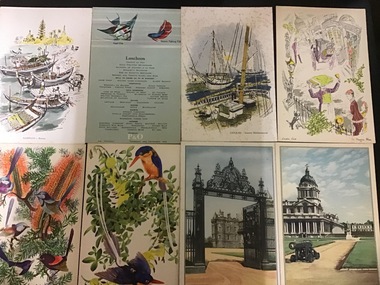 Queenscliffe Maritime Museum
Memorabilia - Ship Menus
Menus used on P&O liners SS Himalaya and SS Arcadia 1955-56. After the Great war of 1914-18, Australia experienced what up until then had been its biggest surge in immigration from Europe. Australia was seen as the great land of opportunity and became one of the top places to migrate to, particularly from Britain. The increase in migration to Australia led Britain’s leading shipping line to the Far East, the Peninsular and Oriental Steam Navigation Company (P&O;), to invest in a fleet of new ships of around 20,000 tonnes each to handle the business coming their way.29 Cruise Ship Menus from P&O cruises 1955-56Peninsula & Oriental Steam Navigation Companycruise liners, migrants, menus, p&o -
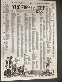 Queenscliffe Maritime Museum
Poster - Copy of Poster listing The First Fleet 1788 passenger lists
The First Fleet comprised the 11 ships that departed from Portsmouth, England on 13 May 1787 to New South Wales, the penal colony that became the first European settlement in Australia. The First Fleet consisted of two Royal Navy vessels, three store ships and six convict transports, carrying between 1,000 and 1,500 convicts, marines, seamen, civil officers and free people (accounts differ on the numbers), and a large quantity of stores. From England, the Fleet sailed south-west to Rio de Janeiro, then east to Cape Town and via the Great Southern Ocean to Botany Bay (Australia), arriving over the period of 18–20 January 1788, taking 250 to 252 days from departure to final arrival. During the period 25–26 January 1788 the fleet moved from Botany Bay to present-day Sydney.A poster listing the names of men and women who landed with the first fleet including provisions and livestockThe First Fleet 1788the first fleet, botany bay, sydney -
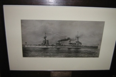 Kyneton RSL Sub Branch
Framed photograph, HMAS Australia
The Australian Navy's first flagship, the battle cruiser HMAS Australia (I) was the centrepiece of the 'Fleet Unit', whose acquisition signalled the RAN's arrival as a credible ocean-going force. The Commonwealth Government decided upon the name Australia, and it proved a popular choice, carefully avoiding any suggestion of favouritism towards any one Australian State. Notwithstanding some construction delays, John Brown delivered Australia £295 000 under budget. Following successful gun, torpedo and machinery trials she commissioned as an Australian unit at Portsmouth, England, on 21 June 1913 under the command of Captain Stephen H. Radcliffe, RN. Two days later the ship hoisted the flag of Rear Admiral George Edwin Patey, MVO (later Vice Admiral Sir George Patey, KCMG, KCVO), who had been selected to command the Australian Fleet. In company with the new light cruiser HMAS Sydney (I), Australia sailed from Portsmouth on 21 July 1913, and their voyage home was seen as a further opportunity to stimulate public awareness and naval sentiment around the British Empire. Arrangements were made at the first opportunity for the flagship to visit many of the principal Australian ports. On the outbreak of World War I Australia (I) operated (with other ships of the Australian Fleet) as a counter to the German East Asiatic Cruiser Squadron under Admiral Graf von Spee. On 11 November 1918, the signing of the Armistice brought the fighting in Europe to an end. On 21 November, the Grand Fleet came out from the Firth-of-Forth in two divisions to meet the German High Seas Fleet steaming across the North Sea to be interned at Scapa Flow. Australia (I) had the honour of leading the port line at the head of her squadron. After returning home Australia (I) resumed the role of RAN flagship. A year later she played the leading part in the naval activities associated with the visit of the Prince of Wales in HMS Renown, but her time was rapidly running out. In November 1921 she returned to Sydney and the following month was paid off into reserve on 12 December 1921. Less than three years later she was prepared for scuttling to comply with the terms of the Washington Naval Treaty of 1922, which provided for a reduction in naval strengths. The RAN had already removed some of the ship's equipment for use in other warships, and now began the deliberate scrapping of Australia (I) by extracting piping and other small fittings. She was towed to sea by tugs and sunk along with her main armament in position 095 degrees, 24 miles from Inner South Head, Sydney, on 12 April 1924. Extracts from http://www.navy.gov.au/HMAS_Australia_(I)Teak frame photograph Metal Plaque on frame: HMAS Australia First flagship of the Royal Australian Navy 1913-1920 Sunk under terms of the Washington Treaty 12th April 1924 navy, world war one, australia, war, wwi, flagship, hmas australia, ran -
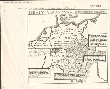 Bendigo Historical Society Inc.
Document - GERMAN HERITAGE SOCIETY COLLECTION: MAPS OF GERMANY (PERIODS OF CHANGE)
Item 21. Maps of Germany (Periods of Change) held in two buff coloured commerce folders. Name written on the front in purple. Three loose copies of the Thirty Years War Map 21a, 21c and 21d. Maps of the Thirty Years War,Europe at the End of the 15th Century, The Reformation in Europe (16th Century), /Europe in the Time of Charles II & James II, The Domination of France 1660 - 85, Europe in the Time of Henry VIII, Germany in 1807 after reconstruction by Napoleon, German Federation 1815, The German Federation 1815, The German Empire of 1871, The Growth of the German Zollverein, Boundaries Before 1918 showing Kingdoms, Duchies, Provinces, etc., of the Former German Empire, the German Empire (1871 - 1918), and Boundaries before 1918 showing Kingdoms, Duchies, Provinces, etc., of the Former German Empire. The last page has a small map of Europe, a small map showing East and West Berlin, German Coats of Arms, Comparative International Figures of Population and a short article titled 'Do You Know Germany'.document, certificate, maps of germany, german heritage society collection - maps of germany (periods of change) -
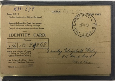 Kew Historical Society Inc
Document - Identity Card, Commonwealth of Australia, Emily Elizabeth Foley, 89 Harp Road, East Kew, 1942, 1942
Identity card issued to Emily Foley in 1942. This type of card was issued to British subjects who were civilians. During World War II everyone in Australia was issued with a personal identity card and was required to report changes of address to the government. These cards were particularly important in the identification and monitoring of Aliens (non-citizen residents) , particularly non-Europeans and Asian residents. (Source: Museum Victoria)Local example of an identity card issued to a Kew resident.Identity card issued to Emily Elizabeth Foley of 89 Harp Road, East Kew. The card uses the for "C.R.3 - Civilian Registration British Subjects". it bears a Camberwell stamp on the front right corner. The Identity Card includes the following inscriptions: Front "V14 / F85 / 29268" Reverse Witness signature: "Ethel Foley" same address identity cards, world war 2 - ii, second world war 1939-1945, australia -
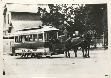 Kew Historical Society Inc
Photograph, Horse Tram, Boroondara General (Kew) Cemetery, 1910
... including overseas scenes sent or received from Europe or the Middle... including overseas scenes sent or received from Europe or the Middle ...The Kew Historical Society's postcard collection includes views of Kew, Melbourne and Greater Melbourne as well as those including overseas scenes sent or received from Europe or the Middle East. They date from the 1890s to the 2000s. These postcards may or may not include the name of the publisher or printer. A number of the cards were published as parts of popular series. A way of dating early postcards is to identify whether the reverse was divided by a central line which became the norm after 1902 in the United Kingdom. However, other postcards produced after this date do not always conform to this print layout.The item forms part of the Laurie Bennett collection of thirty-six postcards and photographs of Kew and early Melbourne, donated to the Kew Historical Society in 1980. The postcards in the Bennett collection, like other images in the Society's holdings date from the 1890s to the present and comprehensively indicate points-of-view or scenes considered historically, aesthetically or socially significant in the period in which they were produced.Black and white photograph of the horse tram in High Street, Kew, outside the Boroondara (Kew) General Cemetery. The horse tram was a form of public transport linking the Cemetery with Victoria Bridge.The reverse of the photo identifies the year as 1910. The photo is one of a series of postcards / photographs donated to the Kew Historical Society by L. Bennett in 1980.Reverse: "1910. Donated by L. Bennett 1980. Reg No. KH-402"horse tram -- kew (vic.), boroondara general (kew) cemetery, public transport -- kew (vic.) -
Kew Historical Society Inc
Journal, Kewriosity : December 1986 / January 1987
Kew playgroups are great! [Highbury Grove; Woodlands Avenue] / p1. A gentle reminder about Kew's By-laws - Don't smoke your neighbour out / p1. Dates for December / p2. [Community] Notices / p2. Christmas services / p2. Commentary - The year that was / Cr Joe Ormando, Mayor of Kew p3. Good gardening - Trees: friends or foes? / Peter Davies p3. Profile - Cr James McKenzie / p4. Family Carols in Petrie Square / G Petrie p4. Would you like to be part of Kewriosity [Editorial committee] / p4. In Brief [Post Office complex classified; Don't forget to put your bottles out; Images of Kew; Kew Full Day-care Centre; School Holiday Program] / p5. Children's Services update [ Kew Children's Services Consultative Committee] / Krista Bell p5. Kew Community House [Courses for 1987; VCE (TOP) ; Pamphlet; Christmas Greetings; Christmas Beak-up] / p6. Overmantle returns to Villa Alba after 90 years / p6. Memories of a motor mechanic [Eric Buzza; Williams Motors; 1st Kew Scouts] / p7. Fine music all the way [3MBS] / p7. What's what in the playground? [Hays Paddock; Willsmere Park; Hyde Park; Eglinton Reserve] / p8. Having fun underwater [Kew Skindiving Club] / p8. Australia's fastest growing sport [East Kew Bowling Club] / G Petrie p8. Keeping you informed [Citizens Advice Bureau] / p8. Kew Citizens' Band [European] Tour Appeal / p8.Kewriosity was a local newsletter combining Kew Council and community news. It was published between November 1983 and June 1994, replacing an earlier Kewriosity [broad] Sheet (1979-84). In producing Kewriosity, Council aimed to provide a range of interesting and informative articles covering its deliberations and decision making, together with items of general interest and importance to the Kew community and information not generally available through daily media outlets.non-fictionKew playgroups are great! [Highbury Grove; Woodlands Avenue] / p1. A gentle reminder about Kew's By-laws - Don't smoke your neighbour out / p1. Dates for December / p2. [Community] Notices / p2. Christmas services / p2. Commentary - The year that was / Cr Joe Ormando, Mayor of Kew p3. Good gardening - Trees: friends or foes? / Peter Davies p3. Profile - Cr James McKenzie / p4. Family Carols in Petrie Square / G Petrie p4. Would you like to be part of Kewriosity [Editorial committee] / p4. In Brief [Post Office complex classified; Don't forget to put your bottles out; Images of Kew; Kew Full Day-care Centre; School Holiday Program] / p5. Children's Services update [ Kew Children's Services Consultative Committee] / Krista Bell p5. Kew Community House [Courses for 1987; VCE (TOP) ; Pamphlet; Christmas Greetings; Christmas Beak-up] / p6. Overmantle returns to Villa Alba after 90 years / p6. Memories of a motor mechanic [Eric Buzza; Williams Motors; 1st Kew Scouts] / p7. Fine music all the way [3MBS] / p7. What's what in the playground? [Hays Paddock; Willsmere Park; Hyde Park; Eglinton Reserve] / p8. Having fun underwater [Kew Skindiving Club] / p8. Australia's fastest growing sport [East Kew Bowling Club] / G Petrie p8. Keeping you informed [Citizens Advice Bureau] / p8. Kew Citizens' Band [European] Tour Appeal / p8. publications -- city of kew (vic.), kewriosity, council newsletters, community newsletters -
Kew Historical Society Inc
Print, Post Office and Police Court Kew, 1907-1915
... including overseas scenes sent or received from Europe or the Middle... including overseas scenes sent or received from Europe or the Middle ...The Kew Historical Society's postcard collection includes views of Kew, Melbourne and Greater Melbourne as well as those including overseas scenes sent or received from Europe or the Middle East. They date from the 1890s to the 2000s. These postcards may or may not include the name of the publisher or printer. A number of the cards were published as parts of popular series. A way of dating early postcards is to identify whether the reverse was divided by a central line which became the norm after 1902 in the United Kingdom. However, other postcards produced after this date do not always conform to this print layout.An enlargement of an original postcard in the collection, created for the purposes of exhibition, depicting the Kew Post Office and Court House (built 1888) on the corner of High Street and Cotham Road. In front of the Post Office is a large Moreton Bay Fig tree. The later Kew War Memorial (opened 1925) necessitated the removal of the tree and the relaocation of the Queen Victoria Jubilee Fountain. kew court house, kew post office -
 Kew Historical Society Inc
Photograph - Flooding of the Yarra River in North Kew, 1934
North Kew, now divided between Kew and Kew East, bordered the Yarra River. As such, it was a region subject to flooding in the Yarra Valley. Development beyond this point (ie Kellett Grove) was limited by the City of Kew's planning regulations. Prior to urban development, the area since European settlement and the first land sales in the district in the 1840s, had been used for dairy farming. Small sepia snapshot taken from the river ramp of a house at 8 Kellett Grove, in what was then known as North Kew. The point of view is from a backyard looking towards Fairfield. Beyond the fence line are two almost submerged houses. A number of people are in a motor driven boat midstream. Fairfield at this period, (ie 1934) was noted for its limited river side development. Verso: 2/12/34 / TAKEN FROM OUR RAMPyarra river -- north kew, floods -- yarra valley, floods -- north kew, floods -- 1929, floods -- 1934, natural disasters -- kew -
 Kew Historical Society Inc
Photograph - 8 Kellett Grove, North Kew, 1929
North Kew, now divided between Kew and Kew East, bordered the Yarra River. As such, it was a region subject to flooding in the Yarra Valley. Development beyond this point (ie Kellett Grove) was limited by the City of Kew's planning regulations. Prior to urban development, the area since European settlement and the first land sales in the district in the 1840s, had been used for dairy farming. Small sepia snapshot taken of the front of 8 Kellett Grove, in what was then known as North Kew. Verso: 8 KELLETT GROVE / NORTH KEW / 1929 / 418 kellett gove -- north kew, californian bungalows, houses -- kellett grove -- kew (vic.) -
 Kew Historical Society Inc
Photograph - Flooding of the Yarra River in North Kew, 1934
North Kew, now divided between Kew and Kew East, bordered the Yarra River. As such, it was a region subject to flooding in the Yarra Valley. Development beyond this point (ie Kellett Grove) was limited by the City of Kew's planning regulations. Prior to urban development, the area since European settlement and the first land sales in the district in the 1840s, had been used for dairy farming. Small sepia snapshot taken from the back yard of a house at 8 Kellett Grove, in what was then known as North Kew. The point of view is from a backyard looking towards Fairfield. Floodwaters have submerged the fence and a clothes line. Verso: BACKYARD NTH. KEWyarra river -- north kew, floods -- yarra valley, floods -- north kew, floods -- 1934, natural disasters -- kew -
 Kew Historical Society Inc
Photograph - Flooding of the Yarra River in North Kew, 1934
North Kew, now divided between Kew and Kew East, bordered the Yarra River. As such, it was a region subject to flooding in the Yarra Valley. Development beyond this point (ie Kellett Grove) was limited by the City of Kew's planning regulations. Prior to urban development, the area since European settlement and the first land sales in the district in the 1840s, had been used for dairy farming. Small sepia snapshot taken from the back yard of a house at 8 Kellett Grove, in what was then known as North Kew. The point of view is from a backyard looking towards Fairfield. Verso: 8 KELLETT GROVEyarra river -- north kew, floods -- yarra valley, floods -- north kew, floods -- 1934, natural disasters -- kew -
 Kew Historical Society Inc
Photograph - Flooding of the Yarra River in North Kew, 1934
North Kew, now divided between Kew and Kew East, bordered the Yarra River. As such, it was a region subject to flooding in the Yarra Valley. Development beyond this point (ie Kellett Grove) was limited by the City of Kew's planning regulations. Prior to urban development, the area since European settlement and the first land sales in the district in the 1840s, had been used for dairy farming. Small sepia snapshot taken from the back yard of a house at 8 Kellett Grove, in what was then known as North Kew. The point of view is from a backyard looking towards Fairfield. Verso: OUR BACKYARD 8 KELLETT GROVEyarra river -- north kew, floods -- yarra valley, floods -- north kew, floods -- 1934, natural disasters -- kew -
 Kew Historical Society Inc
Photograph - View of the Yarra River from 8 Kellett Grove, North Kew, 1948
North Kew, now divided between Kew and Kew East, bordered the Yarra River. As such, it was a region subject to flooding in the Yarra Valley. Development beyond this point (ie Kellett Grove) was limited by the City of Kew's planning regulations. Prior to urban development, the area since European settlement and the first land sales in the district in the 1840s, had been used for dairy farming. The view from the rear of 8 Kellett Grove predates the construction of the Eastern Freeway so provides a rare view of the area before it was built.Small sepia snapshot taken from the back yard of a house at 8 Kellett Grove, in what was then known as North Kew. A tower of the Kew Asylum on the top left of the horizon assist the viewer to recognise that the land to the left of the river is in Kew and Studley Park.Verso: NORTH KEW 1948 / Stamped 51019yarra river -- north kew, kellett grove -- north kew -
 Kew Historical Society Inc
Photograph - Flooding of the Yarra River in North Kew, 1934
North Kew, now divided between Kew and Kew East, bordered the Yarra River. As such, it was a region subject to flooding in the Yarra Valley. Development beyond this point (ie Kellett Grove) was limited by the City of Kew's planning regulations. Prior to urban development, the area since European settlement and the first land sales in the district in the 1840s, had been used for dairy farming. Small sepia snapshot of floodwaters taken from near Kellett Grove, in what was then known as North Kew. The point of view is from a backyard looking towards Fairfield. In the foreground ar two men in a rowboat.Verso: OUR BACKYARD / Stamped 3 163yarra river -- north kew, floods -- yarra valley, floods -- north kew, floods -- 1934, natural disasters -- kew -
 Kew Historical Society Inc
Photograph - Flooding of the Yarra River in North Kew, 1934
North Kew, now divided between Kew and Kew East, bordered the Yarra River. As such, it was a region subject to flooding in the Yarra Valley. Development beyond this point (ie Kellett Grove) was limited by the City of Kew's planning regulations. Prior to urban development, the area since European settlement and the first land sales in the district in the 1840s, had been used for dairy farming. Small sepia snapshot of floodwaters taken from near Willsmere Road, in what was then known as North Kew. The point of view is looking towards Fairfield. In the foreground are two figures viewing a group in a rowboat in the middle of the flooded river. Semi-submerged street lighting indicates that entire streets had been. overwhelmed by the flood waters. Verso: WILLSMERE ROAD NORTH KEW / Stamped 3 163yarra river -- north kew, floods -- yarra valley, floods -- north kew, floods -- 1934, natural disasters -- kew, willsmere road -
 Kew Historical Society Inc
Photograph - Flooding of the Yarra River in North Kew, 1934
North Kew, now divided between Kew and Kew East, bordered the Yarra River. As such, it was a region subject to flooding in the Yarra Valley. Development beyond this point (ie Kellett Grove) was limited by the City of Kew's planning regulations. Prior to urban development, the area since European settlement and the first land sales in the district in the 1840s, had been used for dairy farming. Small sepia snapshot of floodwaters in North Kew. The point of view is of two houses belonging to local families that were surrounded by floodwater. Verso: HYATTS HOUSE / WILLSMERE ROAD / Stamped 3 163yarra river -- north kew, floods -- yarra valley, floods -- north kew, floods -- 1934, natural disasters -- kew, willsmere road -
 Kew Historical Society Inc
Photograph - Flooding of the Yarra River in North Kew, 1934
North Kew, now divided between Kew and Kew East, bordered the Yarra River. As such, it was a region subject to flooding in the Yarra Valley. Development beyond this point (ie Kellett Grove) was limited by the City of Kew's planning regulations. Prior to urban development, the area since European settlement and the first land sales in the district in the 1840s, had been used for dairy farming. Small sepia snapshot of floodwaters in North Kew, from the rear of 8 Kellett Grove. Verso: OUR BACKYARD / Stamped 52yarra river -- north kew, floods -- yarra valley, floods -- north kew, floods -- 1934, natural disasters -- kew, willsmere road -
 Kew Historical Society Inc
Photograph - Grandfather and granddaughter in the yard of 8 Kellett Grove, Kew, 1934
North Kew, now divided between Kew and Kew East, bordered the Yarra River. As such, it was a region subject to flooding in the Yarra Valley. Development beyond this point (ie Kellett Grove) was limited by the City of Kew's planning regulations. Prior to urban development, the area since European settlement and the first land sales in the district in the 1840s, had been used for dairy farming. Vivid photograph contrasting domestic life and relationships with natural disasters such as the flood of 1934.Small sepia snapshot of a grandfather and granddaughter sitting in the backyard of 8 Kellett Grove, North Kew, with the floodwaters stretching behind them.Verso: GRANDDAD AND I IN BACKYARDyarra river -- north kew, floods -- yarra valley, floods -- north kew, floods -- 1934, natural disasters -- kew, willsmere road -
 Kew Historical Society Inc
Photograph - Submerged houses in River Avenue, North Kew, 1934
North Kew, now divided between Kew and Kew East, bordered the Yarra River. As such, it was a region subject to flooding in the Yarra Valley. Development beyond this point (ie Kellett Grove) was limited by the City of Kew's planning regulations. Prior to urban development, the area since European settlement and the first land sales in the district in the 1840s, had been used for dairy farming. Vivid photograph contrasting domestic life and relationships with natural disasters such as the flood of 1934.Small sepia snapshot of two submerged houses belonging to local families in River Avenue, North Kew, during the 1934 floods. The view is presumably from near Kellett Grove looking north towards Fairfield.Verso: COES & HYATTS ROOF / RIVER AVENUE / Stamped: 6414yarra river -- north kew, floods -- yarra valley, floods -- north kew, floods -- 1934, natural disasters -- kew -
 Kew Historical Society Inc
Photograph - Flooding of the Yarra River in North Kew, 1934
North Kew, now divided between Kew and Kew East, bordered the Yarra River. As such, it was a region subject to flooding in the Yarra Valley. Development beyond this point (ie Kellett Grove) was limited by the City of Kew's planning regulations. Prior to urban development, the area since European settlement and the first land sales in the district in the 1840s, had been used for dairy farming. Vivid photograph contrasting domestic life and relationships with natural disasters such as the flood of 1934.Small sepia snapshot of the donors grandfather rescuing the family dog's kennel from rising floodwaters at the rear of 8 Kellett Grove, North Kew, .Verso: DAD SECURING NIPPY'S DOG KENNEL / Stamped 6414yarra river -- north kew, floods -- yarra valley, floods -- north kew, floods -- 1934, natural disasters -- kew -
 Kew Historical Society Inc
Photograph - Flooding of the Yarra River in North Kew, 1934
North Kew, now divided between Kew and Kew East, bordered the Yarra River. As such, it was a region subject to flooding in the Yarra Valley. Development beyond this point (ie Kellett Grove) was limited by the City of Kew's planning regulations. Prior to urban development, the area since European settlement and the first land sales in the district in the 1840s, had been used for dairy farming. .Small sepia snapshot of a local family's house in what was then River Avenue, North Kew being surrounded by floodwaters.Verso: THE SIDE OF RYANSyarra river -- north kew, floods -- yarra valley, floods -- north kew, floods -- 1934, natural disasters -- kew -
 Kew Historical Society Inc
Photograph - Flooding of the Yarra River in North Kew, 1934
North Kew, now divided between Kew and Kew East, bordered the Yarra River. As such, it was a region subject to flooding in the Yarra Valley. Development beyond this point (ie Kellett Grove) was limited by the City of Kew's planning regulations. Prior to urban development, the area since European settlement and the first land sales in the district in the 1840s, had been used for dairy farming. .Small sepia snapshot of what was then River Avenue, North Kew submerged by floodwaters.The photo was taken in the vicinity of 8 Kellett Grove, North Kew. Verso: TAKEN FROM OUR STREET JUST SEE A BIT OF RYAN'S FENCE / 1934yarra river -- north kew, floods -- yarra valley, floods -- north kew, floods -- 1934, natural disasters -- kew -
 Kew Historical Society Inc
Photograph - Flooding of the Yarra River in North Kew, 1934
North Kew, now divided between Kew and Kew East, bordered the Yarra River. As such, it was a region subject to flooding in the Yarra Valley. Development beyond this point (ie Kellett Grove) was limited by the City of Kew's planning regulations. Prior to urban development, the area since European settlement and the first land sales in the district in the 1840s, had been used for dairy farming. .Small sepia snapshot of the devastation caused by the 1934 flood.The photo was taken in the vicinity of Kellett Grove, North Kew and includes the roof of Chipperfield's Boathouse as well as other local houses.Verso: THIS IS CHIPPERFIELD'S BOAT SHEDS & COES & WILLIAMS TAKEN FROM OUR STREET / 1934yarra river -- north kew, floods -- yarra valley, floods -- north kew, floods -- 1934, natural disasters -- kew, chipperfields boathouse -
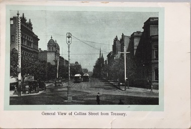 Kew Historical Society Inc
Postcard, General View of Collins Street From Treasury, 1907-1915
... including overseas scenes sent or received from Europe or the Middle... including overseas scenes sent or received from Europe or the Middle ...The Kew Historical Society's postcard collection includes views of Kew, Melbourne and Greater Melbourne as well as those including overseas scenes sent or received from Europe or the Middle East. They date from the 1890s to the 2000s. These postcards may or may not include the name of the publisher or printer. A number of the cards were published as parts of popular series. A way of dating early postcards is to identify whether the reverse was divided by a central line which became the norm after 1902 in the United Kingdom. However, other postcards produced after this date do not always conform to this print layout.The item forms part of the Laurie Bennett collection of thirty-six postcards and photographs of Kew and early Melbourne, donated to the Kew Historical Society in 1980. The postcards in the Bennett collection, like other images in the Society's holdings date from the 1890s to the present and comprehensively indicate points-of-view or scenes considered historically, aesthetically or socially significant in the period in which they were produced.Postcard depicting Collins Street looking west from Spring Street. Reg-No-KH.392 (obsolete number). Donated by L. Bennettcollins street -- melbourne (vic.), postcards -
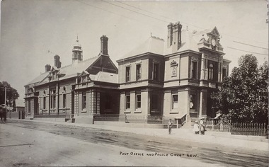 Kew Historical Society Inc
Postcard, Post Office and Police Court Kew, 1907-1915
... including overseas scenes sent or received from Europe or the Middle... including overseas scenes sent or received from Europe or the Middle ...The Kew Historical Society's postcard collection includes views of Kew, Melbourne and Greater Melbourne as well as those including overseas scenes sent or received from Europe or the Middle East. They date from the 1890s to the 2000s. These postcards may or may not include the name of the publisher or printer. A number of the cards were published as parts of popular series. A way of dating early postcards is to identify whether the reverse was divided by a central line which became the norm after 1902 in the United Kingdom. However, other postcards produced after this date do not always conform to this print layout.The item forms part of the Laurie Bennett collection of thirty-six postcards and photographs of Kew and early Melbourne, donated to the Kew Historical Society in 1980. The postcards in the Bennett collection, like other images in the Society's holdings date from the 1890s to the present and comprehensively indicate points-of-view or scenes considered historically, aesthetically or socially significant in the period in which they were produced.Postcard depicting the Kew Post Office and Court House (built 1888) on the corner of High Street and Cotham Road. In front of the Post Office is a large Moreton Bay Fig tree. The later Kew War Memorial (opened 1925) necessitated the removal of the tree and the relaocation of the Queen Victoria Jubilee Fountain. "No-KH-388. 1888. Donated by Mr. L. Bennett. Later buildings joined. Fig tree + Queen Victoria Jubilee Fountain moved to make way for World War I Memorial 1920."kew court house, kew post office, postcards