Showing 235 items matching "farm view"
-
 Kiewa Valley Historical Society
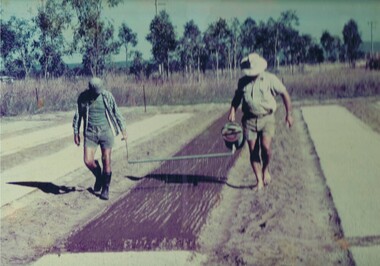
Photograph Tobacco planting, Planting Tobacco seeding, Circa mid to late 1900's
This promotional photograph by the Tobacco Growers Association was in response to a 1935 meeting of tobacco growers from Victoria, South Australia and Queensland which produced four major resolutions for the industry covering the remainder of the 1900s. These four resolutions were: (1) Adequate tariff protection (2) Control of pests and diseases (3) Orderly marketing (4) The formation of an advisory council of growers. History has produced the following results. (1) adequate tariff protection was never achieved,(2) control of disease through benzol vapour (CSIRO) breakthrough, was later identified as carcinogenic, (3) orderly marketing was achieved through (4) the establishment of the Tobacco Growers Association(1984). In October 2006, by way of Government buy back of tobacco leases from growers, resulted in the end of Tobacco farming in Australia (after 136 years of planting the first crop). It was also significant that the major tobacco companies such as Philip Morris and The British American Tobacco Australasia advised the industry that it would source its tobacco requirements overseas by 2009.The remnants of the Tobacco Industry can still be viewed throughout the Kiewa Valley and adjacent regions on the former tobacco farms which still have the tobacco drying sheds and now converted into hay sheds. The problems from the large quantities of carcinogenic infused soil of farmlands in the region, still remains a problem now and for future generations. This particular photograph shows the lack of understanding by farmers and the contracted labour, at that time, and is demonstrated by the bare footed farmer walking next to the seed canister. Some workers did use protective "gum" boots but the majority of farm owners were skeptical of city scientists and their carcinogenic concerns, and it was only after the younger generation of farmers , who had attended Agricultural colleges, encompassed the scientific approach to farm management and began working closely with agricultural scientists. The "she'll be right mate" attitude of the earlier farming/rural community has since mid 1970s, been slowly dissipating. Stricter controls of herbicides and pesticides used in agriculture are now in force. The death of the tobacco industry(2006) resulted in the expansion of the dairy , sheep, beef cattle, venison and lama wool producers in the Kiewa Valley and surrounding regions.Coloured photograph pasted onto a thick wood chip backing. Two galvanised eyelets at the top of the frame, 50mm from each end, with a twine cord stretch from each, for hanging purposes. See also KVHS 0054(B) to KVHS 0054(F)A sign, which has been removed from the picture at some previous point in time is "The Tobacco seed, being so fine, is suspended in water and sown onto the seed base using a watering can [as in the photo] or similar device - August - Sept."tobacco, farming, rural industry, licences, ollie mould, blue mould, benzol vapour -
 Kiewa Valley Historical Society
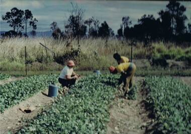
Photograph Tobacco seedlings, Pulling tobacco seedlings for Planting, Circa mid to late 1900s
This promotional photograph by the Tobacco Growers Association was in response to a 1935 meeting of tobacco growers from Victoria, South Australia and Queensland which produced four major resolutions for the industry covering the remainder of the 1900s. These four resolutions were: (1) Adequate tariff protection (2) Control of pests and diseases (3) Orderly marketing (4) The formation of an advisory council of growers. History has produced the following results. (1) adequate tariff protection was never achieved,(2) control of disease through benzol vapour (CSIRO) breakthrough, was later identified as carcinogenic, (3) orderly marketing was achieved through (4) the establishment of the Tobacco Growers Association(19840. In October 2006, by way of Government buy back of tobacco leases from growers, resulted in the end of Tobacco farming in Australia (after 136 years of planting the first crop). It was also significant that the major tobacco companies such as Philip Morris and The British American Tobacco Australasia advised the industry that it would source its tobacco requirements overseas by 2009.The death of the tobacco industry(2006) resulted in the expansion of the dairy , sheep, beef cattle, venison and lama wool producers in the Kiewa Valley and surrounding regions. The remnants of the Tobacco Industry can still be viewed throughout the Kiewa Valley and adjacent regions on the former tobacco farms which still have the tobacco drying sheds and now converted into hay sheds. The problems from the large quantities of carcinogenic infused soil of farmlands in the region, still remains a problem now and for future generations. This particular photograph shows the lack of understanding by farmers and the contracted labour, at that time, and is demonstrated by the lack of protection of hands when handling seedlings and attached soil. Hand and foot protection was rarely used, even when later warnings were issued of the carcinogenic toxicity of the soil. The majority of farm owners, up until Health authorities stepped in the later stages of 1900s, were skeptical of city scientists' "carcinogenic" health warnings and it was only after the younger generation of farmers, who had graduated from Agricultural colleges, encompassed the scientific approach to farm management. The "she'll be right mate" attitude of the farming/rural community has since the 1970s been slowly dissipating. Stricter controls of herbicides and pesticides used in agriculture are now in force.Coloured photograph pasted onto a thick wood chip backing. Two galvanised eyelets at the top of the frame, 50mm from each end, with a twine cord stretch from each, for hanging purposes. See also KVHS 0054A, KVHS0054C to KVHS 0054FA sign, which has been removed from the picture at some previous point in time is "Pulling seedlings for planting"tobacco, farming, rural industry, licences, ollie mould, blue mould, benzol vapour, photograph -
 Kiewa Valley Historical Society
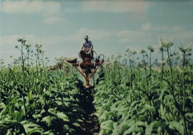
Photograph Topping Tobacco, Tobacco being topped (removal of flower), Circa mid to late 1900's
This promotional photograph by the Tobacco Growers Association was in response to a 1935 meeting of tobacco growers from Victoria, South Australia and Queensland which produced four major resolutions for the industry covering the remainder of the 1900s. These four resolutions were: (1) Adequate tariff protection (2) Control of pests and diseases (3) Orderly marketing (4) The formation of an advisory council of growers. History has produced the following results. (1) adequate tariff protection was never achieved,(2) control of disease through benzol vapour (CSIRO) breakthrough, was later identified as carcinogenic, (3) orderly marketing was achieved through (4) the establishment of the Tobacco Growers Association(1984). In October 2006, by way of Government buy back of tobacco leases from growers, resulted in the end of Tobacco farming in Australia (after 136 years of planting the first crop). It was also significant that the major tobacco companies such as Philip Morris and The British American Tobacco Australasia advised the industry that it would source its tobacco requirements overseas by 2009.The remnants of the Tobacco Industry can still be viewed throughout the Kiewa Valley and adjacent regions on the former tobacco farms which still have the tobacco drying sheds and now converted into hay sheds. The problems from the large quantities of carcinogenic infused soil of farmlands in the region, still remains a problem now and for future generations. This particular photograph shows the lack of understanding by farmers and the contracted labour, at that time, and is demonstrated by the lack of protection of hands when handling seedlings and attached soil. Hand and foot protection was rarely used, even when later warnings were issued of the carcinogenic toxicity of the soil. The majority of farm owners, up until Health authorities stepped in the latter stages of 1900s, were skeptical of city scientists' "carcinogenic" health warnings and it was only after the younger generation of farmers, who had graduated from Agricultural colleges, encompassed the scientific approach to farm management. The "she'll be right mate" attitude of the farming/rural community has since the 1970s been slowly dissipating. Stricter controls of herbicides and pesticides used in agriculture are now in force. The death of the tobacco industry(2006) resulted in the expansion of the dairy , sheep, beef cattle, venison and lama wool producers in the Kiewa Valley and surrounding regions.Coloured photograph pasted onto a thick wood chip backing. Two galvanised eyelets at the top of the frame, 50mm from each end, with a twine cord stretch from each, for hanging purposes. See also KVHS 0054A ,KVHS 0054B and KVHC 0054D to KVHS 0054F A sign, which has been removed from the picture at some previous point in time is "The Tobacco crop being topped (flower removed)". tobacco, farming, rural industry, licences, ollie mould, blue mould, benzol vapour -
 Kiewa Valley Historical Society
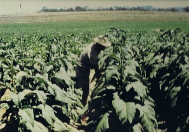
Photograph Tobacco plants, Tobacco fully grown prior to start picking, Circa mid to late 1900's
This promotional photograph by the Tobacco Growers Association was in response to a 1935 meeting of tobacco growers from Victoria, South Australia and Queensland which produced four major resolutions for the industry covering the remainder of the 1900s. These four resolutions were: (1) Adequate tariff protection (2) Control of pests and diseases (3) Orderly marketing (4) The formation of an advisory council of growers. History has produced the following results. (1) adequate tariff protection was never achieved,(2) control of disease through benzol vapour (CSIRO) breakthrough, was later identified as carcinogenic, (3) orderly marketing was achieved through (4) the establishment of the Tobacco Growers Association(1984). In October 2006, by way of Government buy back of tobacco leases from growers, resulted in the end of Tobacco farming in Australia (after 136 years of planting the first crop). It was also significant that the major tobacco companies such as Philip Morris and The British American Tobacco Australasia advised the industry that it would source its tobacco requirements overseas by 2009.The remnants of the Tobacco Industry can still be viewed throughout the Kiewa Valley and adjacent regions on the former tobacco farms which still have the tobacco drying sheds and now converted into hay sheds. The problems from the large quantities of carcinogenic infused soil of farmlands in the region, still remains a problem now and for future generations. This particular photograph shows the lack of understanding by farmers, at that time, and is demonstrated by the lack of protection of hands and no masks over their noses, when handling plants. Hand, nose and foot protection was rarely used, even when later warnings were issued of the carcinogenic toxicity of the soil. The majority of farm owners, up until Health authorities stepped in the latter stages of 1900s, were skeptical of city scientists' "carcinogenic" health warnings and it was only after the younger generation of farmers, who had graduated from Agricultural colleges, encompassed the scientific approach to farm management. The "she'll be right mate" attitude of the farming/rural community has since the 1970s been slowly dissipating. Stricter controls of herbicides and pesticides used in agriculture are now in force. The death of the tobacco industry(2006) resulted in the expansion of the dairy , sheep, beef cattle, venison and lama wool producers in the Kiewa Valley and surrounding regions.Coloured photograph pasted onto a thick wood chip backing. Two galvanised eyelets at the top of the frame, 50mm from each end, with a twine cord stretch from each, for hanging purposes. See also KVHS 0054A to KVHS 0054C and 0054E to KVHS 0054FA sign, which has been removed from the picture at some previous point in time is "The Tobacco fully grown prior to start picking"tobacco, farming, rural industry, licences, ollie mould, blue mould, benzol vapour -
 Kiewa Valley Historical Society
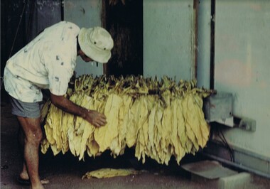
Photograph Tobacco drying leaves, Inspecting Drying tobacco leaves, 1950's to 1999
This promotional photograph by the Tobacco Growers Association was in response to a 1935 meeting of tobacco growers from Victoria, South Australia and Queensland which produced four major resolutions for the industry covering the remainder of the 1900s. These four resolutions were: (1) Adequate tariff protection (2) Control of pests and diseases (3) Orderly marketing (4) The formation of an advisory council of growers. History has produced the following results. (1) adequate tariff protection was never achieved,(2) control of disease through benzol vapour (CSIRO) breakthrough, was later identified as carcinogenic, (3) orderly marketing was achieved through (4) the establishment of the Tobacco Growers Association(19840. In October 2006, by way of Government buy back of tobacco leases from growers, resulted in the end of Tobacco farming in Australia (after 136 years of planting the first crop). It was also significant that the major tobacco companies such as Philip Morris and The British American Tobacco Australasia advised the industry that it would source its tobacco requirements overseas by 2009.The remnants of the Tobacco Industry can still be viewed throughout the Kiewa Valley and adjacent regions on the former tobacco farms which still have the tobacco drying sheds and now converted into hay sheds. The problems from the large quantities of carcinogenic infused soil of farmlands in the region, still remains a problem now and for future generations. This particular photograph shows the lack of understanding by farmers and the contracted labour, at that time, and is demonstrated by the lack of protection of hands when handling the tobacco leaves and nose from tobacco dust. Hand and foot protection was rarely used, even when later warnings were issued of the carcinogenic toxicity of the soil. The majority of farm owners, up until Health authorities stepped in the later stages of 1900s, were skeptical of city scientists' "carcinogenic" health warnings and it was only after the younger generation of farmers, who had graduated from Agricultural colleges, encompassed the scientific approach to farm management. The "she'll be right mate" attitude of the farming/rural community has since the 1970s been slowly dissipating. Stricter controls of herbicides and pesticides used in agriculture are now in force. The death of the tobacco industry(2006) resulted in the expansion of the dairy , sheep, beef cattle, venison and lama wool producers in the Kiewa Valley and surrounding regions.Coloured photograph pasted onto a thick wood chip backing. Two galvanised eyelets at the top of the frame, 50mm from each end, with a twine cord stretch from each, for hanging purposes. See also KVHS 0054A to KVHS 0054D and KVHS 0054Ftobacco, farming, rural industry, licences, ollie mould, blue mould, benzol vapour, photograph -
 Kiewa Valley Historical Society
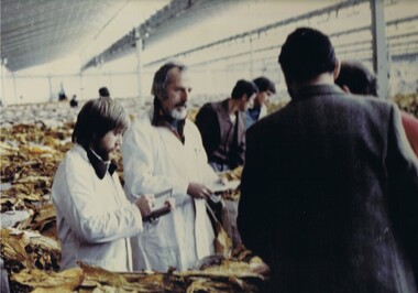
Photograph Tobacco selling, Tobacco sale floor, 1950 to 199
This promotional photograph by the Tobacco Growers Association was in response to a 1935 meeting of tobacco growers from Victoria, South Australia and Queensland which produced four major resolutions for the industry covering the remainder of the 1900s. These four resolutions were: (1) Adequate tariff protection (2) Control of pests and diseases (3) Orderly marketing (4) The formation of an advisory council of growers. History has produced the following results. (1) adequate tariff protection was never achieved,(2) control of disease through benzol vapour (CSIRO) breakthrough, was later identified as carcinogenic, (3) orderly marketing was achieved through (4) the establishment of the Tobacco Growers Association(19840. In October 2006, by way of Government buy back of tobacco leases from growers, resulted in the end of Tobacco farming in Australia (after 136 years of planting the first crop). It was also significant that the major tobacco companies such as Philip Morris and The British American Tobacco Australasia advised the industry that it would source its tobacco requirements overseas by 2009.This particular photograph shows prospective buyers (from the major processing firms of Philip Morris and British American Tobacco Australasia) inspecting the dried tobacco leaves at the Melbourne sales, before 2009, when they moved to overseas growers.The remnants of the Tobacco Industry can still be viewed throughout the Kiewa Valley and adjacent regions on the former tobacco farms, which still have the former tobacco drying sheds but now converted into hay sheds. The death of the tobacco industry(2006) resulted in the expansion of the dairy , sheep, beef cattle, venison and lama wool producers in the Kiewa Valley and surrounding regions. The problems from the large quantities of carcinogenic infused soil of farmlands in the region, still remains a problem now and for future generations. The tighter restrictions of where the final product can be smoked and the higher tax levied (no tariff protection) was the main contributor to this one time lucrative industry's demise.Coloured photograph pasted onto a thick wood chip backing. Two galvanised eyelets at the top of the frame, 50mm from each end, with a twine cord stretch from each, for hanging purposes. See also KVHS 0054A to KVHS 0054EA sign, which has been removed from the picture at some previous point in time is "Tobacco sale floor"tobacco, farming, rural industry, licences, ollie mould, blue mould, benzol vapour, photograph -
 Eltham District Historical Society Inc
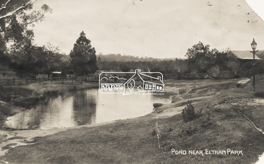
Photograph - Photo Postcard, Pond near Eltham Park, c.1910
This card depicts the pond near Eltham Park (later Eltham Lower Park) circa 1910. The view is taken from Maria Street (Main Road) opposite Dalton Street looking northwest across the Dalton Street road extension reserve (now Wingrove Park Trail) and Jarrold farm. A haystack is visible. Also visible is a gas streetlight and White Cloud cottage which belonged to the Jarrold family From the same collection as accession no. 00778, (Yarra at Eltham) - sent from Eltham and addressed to "Mr J. L. Brown, "Elthamville", Tinning Street, Brunswick" "with love from Nellie" who was most probably a member of the extended Brown family, and no. 00780 (Eltham, J.H. Clark Photo - dated 20 May 1911). Sending postcards to family and friends including short messages was a common form of communication in the early 20th century. Part of a slide show presentation "Bridges & Waterways of the Shire" by Russell Yeoman to the 13 September 1989 Society meeting. The presentation included slides of historic photos from the Shire of Eltham Pioneers collections as well as several recent views.Sending postcards to family and friends including short messages was a common form of communication in the early 20th century.Sepia postcard in very poor condition which has been removed from an album. Glue residue and album page adhering preventing information being readFront: Pond near Eltham Parkpostcard, eltham, pond, dalton street, duck pond, eltham park, elthamville, gas lamp, haystack, jarrold cottage, jarrold property, main road, maria street, white cloud cottage, wingrove park trail -
 Eltham District Historical Society Inc
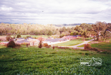
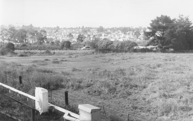
Photograph, View from Porter Street, Eltham to south east, c.1994, 1994c
... Fabbro farm. View from Porter Street, Eltham to south east, c ...Colour photograph of view southeast from Porter Street, Eltham c.1994 showing new housing development on Riverview Estate formerly Fabbro farm.porter street, eltham, riverview estate, m fabbro -
 Eltham District Historical Society Inc
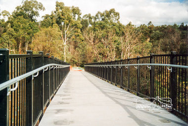
Photograph, Doug Orford, Completion of bridge works across Yarra River at rear of Eltham Lower Park, July 2004, July 2004
Brand new Eltham-Templestowe footbridge over the Yarra River off Homestead Road, Eltham which was completed in July 2004. The Yarra River Footbridge was opened in August 2004 and links the Diamond Creek Trail between the Shire of Nillumbik and City of Manningham. It is a shared pathway and also links with the Main Yarra Trail. It affords lovely views over the Yarra River.One of three colour photographs.yarra river, eltham south, eltham lower park, lenister farm, homestead road, shared pathway, diamond creek trail, footbridge -
 Warrnambool and District Historical Society Inc.
Album - Farm & Bush views, Late 19th century or early 20th century
... mounted on heavy card. Album Farm & Bush views ...This album contains a number of photos taken around the Otways. They depict a number of people with horses, buggies and tents along bush tracks. There are scenes of Lochard Gorge and the Curdies River at Peterborough, as well as farming scenes. The Otway Ranges was a popular place for day trips and small holidays for the people of the district. Warrnambool and District Historical Society has albums from the Swinton family which depict similar scenes. Dress of the people in the photos would indicate that this trip occurred around the turn of the 20th century. This album has artistic and aesthetic significance as the photos contained within this album are quite beautiful. It also has historical and social significance as it is depicts a typical activity of the time. Brown cover with black floral pattern on front. Back cover is plain. Rectangular in shape. Contains photographs mounted on heavy card.warrnambool, album, photo album, otway ranges, the otways, loch ard gorge,, warrnambool photographs of the past, warrnambool photos -
 Eltham District Historical Society Inc
Photograph, View at Eltham, Vic, c.1924
Copy of possible Rose Stereograph Co. postcard “View at Eltham, Vic.”, c.1924 looking southwest from Main Road near York Street to Bridge Street and the original 1875 bridge across what is now the Alistair Knox Park The land in the foreground was first bought from the Crown by J.M. Holloway in 1851. The land was sub-divided and called "Little Eltham". Bridge Street was created as part of the sub-division. Most of the sub-division was residential lots but the creek valley was divided into lots for small farms. Council started to buy the land for the Eltham Town park in the early 1960s. The area was used as a garbage tip and filled above the flood plain of the creek. Development of the land for a park began in the early 1970s. The house on the right was owned for many years by the Hill family until Council bought it in the early 1960s. The house was built in the 1850s or 60s. The house on the left stood on what is now the southwest corner of Susan and Bridge Streets. The Braithwaite family was associated with this house. The double line of fencing in the foreground was a continuation of York Street to the creek. The Bridge Street bridge was built in 1875 and replaced in 1958. (Ref: Early view of Little Eltham; Byways of History by Colleen Ison, Publication unk, 24 August 1982) Reproduced on p61 of 'Pioneers & Painters' Date estimated on same as View at Hurstbridge featuring Wattle Valley EstateThis photo forms part of a collection of photographs gathered by the Shire of Eltham for their centenary project book,"Pioneers and Painters: 100 years of the Shire of Eltham" by Alan Marshall (1971). The collection of over 500 images is held in partnership between Eltham District Historical Society and Yarra Plenty Regional Library (Eltham Library) and is now formally known as the 'The Shire of Eltham Pioneers Photograph Collection.' It is significant in being the first community sourced collection representing the places and people of the Shire's first one hundred years.Digital image 120 format B&W negative Prints 17 x 25 cm and 10 x 15 cmsepp, shire of eltham pioneers photograph collection, eltham, bridge street, bridge, alistair knox park, braithwaite, bridge street bridge, eltham town park, hill family home, main road, pioneers and painters, york street -
 Eltham District Historical Society Inc
Photograph, Henley Bridge, Spring Excursion, Exploring the Upper Yarra, 22 October 1995, 22/10/1995
[article by Bettina Woodburn in EDHS Newsletter No. 105, November 1995:] EXPLORING THE UPPER YARRA - We enjoyed the Spring Excursion, this year "Exploring the Upper Yarra" - in spite of the constant rain and the countryside under the cloud cover, especially in the valleys, being mainly shiny shades of green. The occasional fields of buttercups, clumps of arum lilies and splendid rhododendron and other flowering bushes became very special. The Cobb and Co coach was warm and a cosy retreat as we zig-zagged on the highways and byways to glimpse the Yarra River, upstream and down, its secret places, and particularly the many bridges. Russell excelled as 'Poet Laureate', reading from Dacre Smyth's book. This 1979 publication includes paintings of all the bridges along the river with poems and brief descriptions of each one. Some of the bridges are in out-of-the-way places and are not very well known. We looked forward to hearing the poetry as much as seeing the 'constructions'… Big Pat (was he short or tall, lean or fat? - he did win the £200 reward for discovering gold and had the creek named after him), about the 'Eddies'?, and the disliked 'meccano' bridge in Warburton, etc. etc. The hot roast lunch in the old Reefton Hotel was also most welcome. It was easy to imagine it peopled by miners and early settlers. Starting by crossing the new (1974) concrete bridge at Warrandyte we headed through Wonga Park with views to the Christmas Hills and to the escarpment of the Yering Gorge, which causes flood waters to back up through the Yarra Glen plain, so avoiding disasters downstream. At the end of a long driveway we found the wooden, privately owned Henley Bridge (1935 after the 1934 floods). This facilitates access to different parts of Henley Farm and to Lilydale. Everard Park, named after Blanche Shallard's father, a State Member for 17 years, below the Highway Yarra crossing was in need of care. It is 10 miles from Yarra Glen by road but, as "Yarra Marra” canoeists well know, 32 winding miles down by water. After more delightful countryside scenes we joined the Warburton Highway at Woori Yallock. From the old Railway Station at Launching Place the Centennial Trail for walkers, cyclists and horse riders has replaced the rails. The line from Lilydale was opened in 1901, and the last diesel freight train ran to Warburton in 1965. It continued to rain as we had morning tea in Warburton in a shelter between footbridges. From here we continued upstream past the Bridge to O'Shannassy Lodge and Reservoir, Starvation Creek, and the Peninsular tunnel (miners dug it as at Pound Bend) which we visited (scrambling down those steps!) on our return after lunch. Our furthermost point was the Upper Yarra Dam Reserve (and vast catchment area). Finished in 1957 after ten years' work and 100 years after Yan Yean, it supplies much of Melbourne's water. After crossing the 30m Launching Place Bridge to the Eltham side of the Yarra and Healesville, we saw in the distance the Yarra Glen Timber Trestle Bridge over the river flats "the longest for years in the land it was said!" Harry's dream of "better weather over the Divide" unfortunately didn't come true, but I'm sure we 36 members will retain happy memories of a day that was wet and green and filled with Bridges. Situated on the Yarra River, 5.5 kms south of Christmas Hills on private property. This timber trestle bridge is said to have been built some time after 1907 by Melbourne master-builder, David Mitchell (the father of Dame Nellie Melba), to connect his two "Henley Farm" properties with Lilydale. In earlier days, when the McPhersons owned the property, their children used a punt to cross the river to attend Yering Primary School. This private bridge is best viewed from the end of Wendy Way. - Source: Christmas Hills Past and Present, Yarra Glen & District Historical Society, 2004.Two colour photographsactivities, henley bridge, upper yarra -
 Eltham District Historical Society Inc
Photograph, Spring Excursion, Exploring the Upper Yarra, 22 October 1995, 22/10/1995
[article by Bettina Woodburn in EDHS Newsletter No. 105, November 1995:] EXPLORING THE UPPER YARRA - We enjoyed the Spring Excursion, this year "Exploring the Upper Yarra" - in spite of the constant rain and the countryside under the cloud cover, especially in the valleys, being mainly shiny shades of green. The occasional fields of buttercups, clumps of arum lilies and splendid rhododendron and other flowering bushes became very special. The Cobb and Co coach was warm and a cosy retreat as we zig-zagged on the highways and byways to glimpse the Yarra River, upstream and down, its secret places, and particularly the many bridges. Russell excelled as 'Poet Laureate', reading from Dacre Smyth's book. This 1979 publication includes paintings of all the bridges along the river with poems and brief descriptions of each one. Some of the bridges are in out-of-the-way places and are not very well known. We looked forward to hearing the poetry as much as seeing the 'constructions'… Big Pat (was he short or tall, lean or fat? - he did win the £200 reward for discovering gold and had the creek named after him), about the 'Eddies'?, and the disliked 'meccano' bridge in Warburton, etc. etc. The hot roast lunch in the old Reefton Hotel was also most welcome. It was easy to imagine it peopled by miners and early settlers. Starting by crossing the new (1974) concrete bridge at Warrandyte we headed through Wonga Park with views to the Christmas Hills and to the escarpment of the Yering Gorge, which causes flood waters to back up through the Yarra Glen plain, so avoiding disasters downstream. At the end of a long driveway we found the wooden, privately owned Henley Bridge (1935 after the 1934 floods). This facilitates access to different parts of Henley Farm and to Lilydale. Everard Park, named after Blanche Shallard's father, a State Member for 17 years, below the Highway Yarra crossing was in need of care. It is 10 miles from Yarra Glen by road but, as "Yarra Marra” canoeists well know, 32 winding miles down by water. After more delightful countryside scenes we joined the Warburton Highway at Woori Yallock. From the old Railway Station at Launching Place the Centennial Trail for walkers, cyclists and horse riders has replaced the rails. The line from Lilydale was opened in 1901, and the last diesel freight train ran to Warburton in 1965. It continued to rain as we had morning tea in Warburton in a shelter between footbridges. From here we continued upstream past the Bridge to O'Shannassy Lodge and Reservoir, Starvation Creek, and the Peninsular tunnel (miners dug it as at Pound Bend) which we visited (scrambling down those steps!) on our return after lunch. Our furthermost point was the Upper Yarra Dam Reserve (and vast catchment area). Finished in 1957 after ten years' work and 100 years after Yan Yean, it supplies much of Melbourne's water. After crossing the 30m Launching Place Bridge to the Eltham side of the Yarra and Healesville, we saw in the distance the Yarra Glen Timber Trestle Bridge over the river flats "the longest for years in the land it was said!" Harry's dream of "better weather over the Divide" unfortunately didn't come true, but I'm sure we 36 members will retain happy memories of a day that was wet and green and filled with Bridges.Two colour photographsactivities, upper yarra, upper yarra dam -
 Eltham District Historical Society Inc
Photograph, Yarra River from Henley Bridge, Kangaroo Ground, Spring Excursion, Exploring the Upper Yarra, 22 October 1995, 22/10/1995
[article by Bettina Woodburn in EDHS Newsletter No. 105, November 1995:] EXPLORING THE UPPER YARRA - We enjoyed the Spring Excursion, this year "Exploring the Upper Yarra" - in spite of the constant rain and the countryside under the cloud cover, especially in the valleys, being mainly shiny shades of green. The occasional fields of buttercups, clumps of arum lilies and splendid rhododendron and other flowering bushes became very special. The Cobb and Co coach was warm and a cosy retreat as we zig-zagged on the highways and byways to glimpse the Yarra River, upstream and down, its secret places, and particularly the many bridges. Russell excelled as 'Poet Laureate', reading from Dacre Smyth's book. This 1979 publication includes paintings of all the bridges along the river with poems and brief descriptions of each one. Some of the bridges are in out-of-the-way places and are not very well known. We looked forward to hearing the poetry as much as seeing the 'constructions'… Big Pat (was he short or tall, lean or fat? - he did win the £200 reward for discovering gold and had the creek named after him), about the 'Eddies'?, and the disliked 'meccano' bridge in Warburton, etc. etc. The hot roast lunch in the old Reefton Hotel was also most welcome. It was easy to imagine it peopled by miners and early settlers. Starting by crossing the new (1974) concrete bridge at Warrandyte we headed through Wonga Park with views to the Christmas Hills and to the escarpment of the Yering Gorge, which causes flood waters to back up through the Yarra Glen plain, so avoiding disasters downstream. At the end of a long driveway we found the wooden, privately owned Henley Bridge (1935 after the 1934 floods). This facilitates access to different parts of Henley Farm and to Lilydale. Everard Park, named after Blanche Shallard's father, a State Member for 17 years, below the Highway Yarra crossing was in need of care. It is 10 miles from Yarra Glen by road but, as "Yarra Marra” canoeists well know, 32 winding miles down by water. After more delightful countryside scenes we joined the Warburton Highway at Woori Yallock. From the old Railway Station at Launching Place the Centennial Trail for walkers, cyclists and horse riders has replaced the rails. The line from Lilydale was opened in 1901, and the last diesel freight train ran to Warburton in 1965. It continued to rain as we had morning tea in Warburton in a shelter between footbridges. From here we continued upstream past the Bridge to O'Shannassy Lodge and Reservoir, Starvation Creek, and the Peninsular tunnel (miners dug it as at Pound Bend) which we visited (scrambling down those steps!) on our return after lunch. Our furthermost point was the Upper Yarra Dam Reserve (and vast catchment area). Finished in 1957 after ten years' work and 100 years after Yan Yean, it supplies much of Melbourne's water. After crossing the 30m Launching Place Bridge to the Eltham side of the Yarra and Healesville, we saw in the distance the Yarra Glen Timber Trestle Bridge over the river flats "the longest for years in the land it was said!" Harry's dream of "better weather over the Divide" unfortunately didn't come true, but I'm sure we 36 members will retain happy memories of a day that was wet and green and filled with Bridges.Colour photographactivities, upper yarra, henley bridge -
 Orbost & District Historical Society
black and white photograph, February 1971
This photograph is an aerial view of the township of Orbost taken by the Bairnsdale Advertiser newspaper. It was taken from the northern end of the town. The 1971 flood was the the worst flood on record. At Jarrahmond it was at least 11 metres and up to one and a half kilometres wide on the flats causing enormous damage to the flood plain. Records say that "The brown floodwater stain in Bass Strait could be seen from passing airliners." Considerable damage was done to railway infrastructure, roads and farms. More information from the APRIL, 2008 newsletter by John Phillips. (see orbosthistory.com.au)This is a pictorial record of a significant event in the history of Orbost,A black / white aerial photograph of a township with floodwaters in the background.on back - "Note main current through the lagoon 1971."orbost-floods-1971 bairnsdale-advertiser orbost-township -
 Ringwood and District Historical Society
Pamphlet, G.A. Green, Auction Sale Brochure - Garden Farms Estate, Ringwood, Victoria - 1919, 1919
Multi-fold brochure advertising public auction of one-acre, 2-acre, 5-acre and 8-acre allotments in Ringwood and Bayswater on Saturday 12th April, 1919. Brochure includes terms of sale, description of subdivision features and local facilities, and photographic images of the area.Subdivison includes Canterbury Road Heathmont, Armstrong Road Heathmont, Armstrong Road Bayswater, Bungalook Road Heathmont, Bungalook Road Bayswater, and Orchard Road Bayswater. Road shown as Bayswater Road to Bayswater became Mountain Highway Bayswater. Vendor: H.E.B.Armstrong, Auctioneers: Coghill & Haughton, 79 Swanston Street Melbourne, Telephone Central 2793, in conjunction with J.B. McAlpin, Ringwood, Opposite Station, Telephone Ringwood 7. (Map) Woodcock & McCormack, Civil Engineers Architects & Surveyors, 430 Little Collins Street, Melbourne, Phone 3241 Central. MOST OF THE MONEY COMES OUT OF THE LAND. And more money can be obtained from anb acre of fruit than from an acre of any other produce. But you do not have to grow fruit on Garden Farms Estate. You can go in for - Outer Suburban Home - Market Garden - Orchard - Pig Raising - Poultry Farm - Small Dairy Farm - Small Fruits - Floral Culture - Scent and Bee Farm - Or just for a Week-end Home. RINGWOOD - THE PLACE TO LIVE. The Beautiful Ringwood District has so many natural attractions, that half a Land Agent's work is done in just showing a prospective buyer round and about. Ringwood has a pull of its own that attracts folk, proved beyond doubt by its rapid development within the last decade (spite the war). First, it is high and healthy, picturesque and undulating, convenient of access, sufficiently close to the Metropolis for City and Business folk to live at Ringwood. Its development is solid, because most of its people are industrious husbandmen, real producers, who have turned idle hills into smiling gardens. These are the kind of real people to live amongst; ones who wear out their spades. The rapidly-developing town has excellent Stores, Trade and Repair Shops Churches, Banks, Telephone Exchange, Weekly General Market, Cool Stores, and good Private and State Schools, etc.; is Electrically lit, has Metropolitan Water Supply, and generally provides so that practically all shopping can be done locally. WHY RINGWOOD MUST GROW. Ringwood is a great centre and must be a greater. Two rapidly-developing railways junction here. The passengers from Ringwood Station cityward, in one year, number 250,000. Ringwood will be the terminus of the Outer Suburban Electric Eastern Railway. Its natural boundaries are the River Yarra on the North, Dandenong Creek on the South, the popular town of Croydon on the East, and the suburb of Mitcham on the West. This is a large territory that is steadily being converted from intense culture, and then it might be called (as regards its gardens) "The Devon Territory of Victoria." ARMSTRONG ROAD. This new road traverses Garden Farms Estate from its northern boundary on the main Canterbury Road, across Dandenong Creek, to its southern boundary on the main Bayswater Road, and will provide a long-desired additional link of communication between Bayswater and Ringwood. The 1-acre building sites on Bayswater Road are within 8 minutes' walk of the Bayswater Railway Station, and the Canterbury Road frontages are only 1-1/2 miles from Ringwood Station, and 1/2 mile from the Railway Station site of Canterbury Road; therefore, the whole Estate is easy of access and there should be a large demand for land so favourably placed. (Image) Cultivation Field - Potatoes on Lot 28 (Image) Picture of Bayswater Creek Flats. (Image) View from "Korumbeen" where Mr. Armstrong lived on Garden Farms Estate. Estate outlined in white ring. (Image) Site of New Bridge over Dandenong Creek. (Image) On one of the timbered lots adjoining railway. (Image) This Dandenong Creek traveres the Estate. (Image) Main Fern Tree Gully Line bisects the Estate. -
 Ringwood and District Historical Society
Photograph, View from railway line at Madden Street Ringwood, looking towards New St. Flower farm dam centre - to left. 1960
Typed below photograph, "From railway line at Madden St. looking towards New St. Flower farm dam centre - to left. 1960". -
 Marysville & District Historical Society
Postcard (item) - Colour photographs, Murray Views, Marysville 12 Views, 1950's
A fold out postcard of 12 colour photographs of scenes and landscapes in and around Marysville in Victoria.A fold out postcard 12 colour photographs of scenes and landscapes in and around Marysville in Victoria. These photographs were produced by Murray Views in Gympie, Queensland as a souvenir of Marysville.Marysville/ 12 VIEWS PRODUCED BY MURRAY VIEWS./ GYMPIE./ Q COPYRIGHT SAMUEL LEE & CO., PRINTERS. STEAVENSON'S FALLS, MARYSVILLE, VIC. TOURISTS AT MARYSVILLE, VIC. "FRUIT SALAD FARM", MARYSVILLE MAIN STREET, MARYSVILLE, VIC. ROAD SCENE, MARYSVILLE, VIC. THE CROSSWAYS, MARYSVILLE, VIC ROAD TO CUMBERLAND VALLEY, MARYSVILLE PANORAMA FROM BLACK SPUR, MARYSVILLE ROAD, MARYSVILLE, VIC. NICHOLL'S LOOKOUT, MARYSVILLE, VIC. TREE FERNS, MARYSVILLE, VIC. THE BRIDGE, MARYSVILLE, VIC.steavenson falls (image 1), tourists in marysville (image 2), taggerty river (image 3), fruit salad farm (image 4), main street marysville (image 5), road scene marysville (image 6), the crossways (image 7), cumberland valley (image 8), black spur (image 9), nicholl's lookout (image 10), tree ferns (image 11), bridge (image 12), marysville, victoria, postcard, souvenir, murray views -
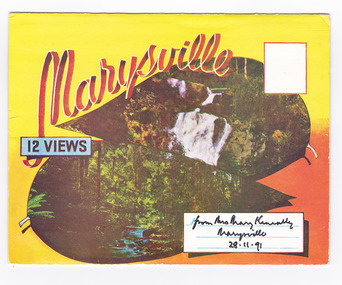 Marysville & District Historical Society
Postcard (item) - Colour photographs, Murray Views, Marysville 12 Views, 1950's
A fold out postcard of 12 colour photographs of scenes and landscapes in and around Marysville in Victoria.A fold out postcard 12 colour photographs of scenes and landscapes in and around Marysville in Victoria. These photographs were produced by Murray Views in Gympie, Queensland as a souvenir of Marysville.Marysville/ 12 VIEWS from Mrs Mary Keneally/ Marysville/ 28.11.91 PRODUCED BY MURRAY VIEWS./ GYMPIE./ Q COPYRIGHT SAMUEL LEE & CO., PRINTERS. STEAVENSON'S FALLS, MARYSVILLE, VIC. TOURISTS AT MARYSVILLE, VIC. "FRUIT SALAD FARM", MARYSVILLE MAIN STREET, MARYSVILLE, VIC. ROAD SCENE, MARYSVILLE, VIC. THE CROSSWAYS, MARYSVILLE, VIC ROAD TO CUMBERLAND VALLEY, MARYSVILLE PANORAMA FROM BLACK SPUR, MARYSVILLE ROAD, MARYSVILLE, VIC. NICHOLL'S LOOKOUT, MARYSVILLE, VIC. TREE FERNS, MARYSVILLE, VIC. THE BRIDGE, MARYSVILLE, VIC.steavenson falls (image 1), tourists in marysville (image 2), taggerty river (image 3), fruit salad farm (image 4), main street marysville (image 5), road scene marysville (image 6), the crossways (image 7), cumberland valley (image 8), black spur (image 9), nicholl's lookout (image 10), tree ferns (image 11), bridge (image 12), marysville, victoria, postcard, souvenir, murray views -
 Marysville & District Historical Society
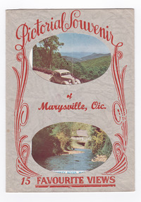
Postcard (item) - Colour and black and white photographs, Murray Views, Pictorial Souvenur of Marysville, Vic. 15 Favourite Views, 1950's
A fold out postcard of 15 colour and black and white photographs of scenes and landscapes in and around Marysville in Victoria.A fold out postcard of 15 colour and black and white photographs of scenes and landscapes in and around Marysville in Victoria. These photographs were produced by Murray Views in Gympie, Queensland as a souvenir of Marysville.Pictorial Souvenir/ of/ Marysville, Vic./ 15 Favourite Views PRODUCED BY MURRAY VIEWS. GYMPIE. Q. COPYRIGHT SAMUEL LEE & CO., PRINTERS Serial No. R 4152 NICHOLL'S LOOKOUT, MARYSVILLE, VIC. TAGGERTY RIVER, MARYSVILLE, VIC ROAD SCENE, MARYSVILLE, VIC. MAIN STREET, MARYSVILLE, VIC. THE CROSSWAYS, MARYSVILLE, VIC. FRUIT SALAD FARM, MARYSVILLE, VIC. ROAD TO CUMBERLAND VALLEY, MARYSVILLE, VIC. CROSSWAYS CABARET, MARYSVILLE, VIC. TREE FERNS, MARYSVILLE, VIC. STEVENSON'S FALLS, MARYSVILLE, VIC. Looking towards Marysville, Vic. Tourists at Marysville, Vic. Taggerty River, Marysville, Vic. On Buxton Road, Marysville, Vic. Panorama from Black Spur, Marysville Road, Marysville, Vic.marysville, victoria, souvenir, postcard, nicholl's lookout (image 1), taggerty river (image 2), road scene (image 3), main street marysville (image 4), crossways hotel (image 5), fruit salad farm (image 6), cumberland valley (image 7), crossways cabaret (image 8), tree ferns (image 9), steavenson falls (image 10), marysville view (image 11), tourists marysville (image 12), taggerty river (image 13), buxton road (image 14), black spur (image 15) -
 Marysville & District Historical Society
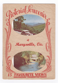
Postcard (item) - Colour and black and white photographs, Pictorial Souvenir of Marysville, Vic. 15 Favourite Views
A fold out postcard of 15 colour and black and white photographs of scenes and landscapes in and around Marysville in Victoria.A fold out postcard of 15 colour and black and white photographs of scenes and landscapes in and around Marysville in Victoria. These photographs were produced by Murray Views in Gympie, Queensland as a souvenir of Marysville.Pictorial Souvenir/ of/ Marysville, Vic./ 15 Favourite Views PRODUCED BY MURRAY VIEWS. GYMPIE. Q. COPYRIGHT SAMUEL LEE & CO., PRINTERS Serial No. R 4152 NICHOLL'S LOOKOUT, MARYSVILLE, VIC. TAGGERTY RIVER, MARYSVILLE, VIC ROAD SCENE, MARYSVILLE, VIC. MAIN STREET, MARYSVILLE, VIC. THE CROSSWAYS, MARYSVILLE, VIC. FRUIT SALAD FARM, MARYSVILLE, VIC. ROAD TO CUMBERLAND VALLEY, MARYSVILLE, VIC. CROSSWAYS CABARET, MARYSVILLE, VIC. TREE FERNS, MARYSVILLE, VIC. STEVENSON'S FALLS, MARYSVILLE, VIC. Looking towards Marysville, Vic. Tourists at Marysville, Vic. Taggerty River, Marysville, Vic. On Buxton Road, Marysville, Vic. Panorama from Black Spur, Marysville Road, Marysville, Vic.marysville, victoria, souvenir, postcard, nicholl's lookout (image 1), taggerty river (image 2), road scene (image 3), main street marysville (image 4), crossways hotel (image 5), fruit salad farm (image 6), cumberland valley (image 7), crossways cabaret (image 8), tree ferns (image 9), steavenson falls (image 10), marysville view (image 11), tourists marysville (image 12), taggerty river (image 13), buxton road (image 14), black spur (image 15) -
 Marysville & District Historical Society
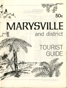
Booklet (Item) - Tourist guide, Ian and Danese Walshe et al, MARYSVILLE and district TOURIST GUIDE, 1982
A tourist guide outlining services, accommodation, activities and places of interest to visit in and around Marysville and the local district.A tourist guide outlining services, accommodation, activities and places of interest to visit in and around Marysville and the local district.marysville, victoria, australia, tourist guide, marysville hotel, castles' store, hawthorne's corner shop, tudor lodge, black spur motel and caravan park, buxton general store, golden fleece roadhouse, marysville garage, burrengeen park, lake mountain, steavenson falls, nanda binya lodge, alpenglow nursery, black spur inn hotel, silver stream trout farm, mccfarlane's grocery, barton's drapery, marysville newsagency, eildon explorer, beauty spot nursery, crossways, pumpernickel, mckenzie's tourist services, blue hills riding school, mountain view horse hire, pitt's garage, maryton park, j l gould sawmill, eildon deer park, eildon weir, maroondah dam, snob's creek, healesville sanctuary, graceburn park, cathedral range, beauty spot walk, tree fern gully walk, michaeldene track, keppel track, woods lookout track, cumberland scenic reserve, cambarville, the big tree, cora-lyn falls, barton's lookout, cumberland falls, sovereign view, wirreanda festival, scenic motel, tower motel, marylands guest house, kooringa guest house, marylyn guest house, mountain lodge, el kanah, marysville hotel motel, buxton hotel motel, black spur inn, buxton caravan park, marysville caravan park, the cumberland, marysville recreation and fun park -
 Marysville & District Historical Society
Booklet (Item) - Leisure guide, Michael Chesire & Associates Pty. Ltd, MARYSVILLE & DISTRICT LEISURE GUIDE-AUTUMN/WINTER, 1986, 1986
A free leisure guide to Marysville and the surrounding district published for Autumn and Winter, 1986. This was produced by Michael Cheshire as a free publication to promote tourism in Marysville and the surrounding district. It includes maps of the Big River Valley, Cumberland Valley, Lady Talbot Forest Drive, the Marysville area, and the township of Marysville. It was released in the autumn of 1986 and was sponsored by the Marysville Tourist & Progress Association. The Association was formed in November 1907 to promote tourism within the area. This included the physical creation of signage, parklands, roads, and walks to various attractions. A free leisure guide to Marysville and the surrounding district published for Autumn and Winter, 1986.marysville, victoria, australia, leisure guide, michael cheshire & associates pty ltd, marysville golf club, blackwood lodges, sir colin mackenzie fauna park, lake eildon, fraser national park, yarra valley wineries, marysville coach tours, kooringa, marylands guest house, lady talbot forest drive, wishing well, taggerty river recreation area, athols abbey, phantom falls, keppel falls, the beeches walking track, marylyn guest house, kufstein inn motel, the cumberland, marysville tourist & progress association, marysville newsagency & general store, crossways restaurant & motel, beauty spot walk, tree fern gully walk, michaeldene track, keppel track, woods lookout track, marysville hotel motel, lake mountain ski hire, marysville recreation and fun park, mytanta horseback safaris, upper big river valley, the big culvert, marysville mountain view horse hire, maryton park, amber view holiday lodges, cathedral restaurant, the top shop, tower motel, menzes garage, beauty spot nursery, marysville ski hire, lake mountain ski school, faraway forest, scenic motel, buxton trout farm, marysville hardware, timbertop steakhouse, marysville trout farm, healesville sanctuary, buxton hotel motel, nanda binya lodge, buxton antique and furniture mart, the black spur inn hotel, alexandra, lake mountain, geoffrey pope & associates -
 Marysville & District Historical Society
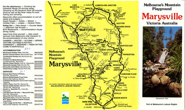
Ephemera (Item) - Tourist Guide, Melbourne's Mountain Playground Marysville Victoria Australia, Unknown
A fold out tourist guide to Marysville and the surrounding district.A fold out tourist guide to Marysville and the surrounding district.marysville, victoria, australia, steavenson falls, marysville golf club, cathedral range, blackwood holiday flats, cumberland holiday inn, kooringa conference and holiday centre, marylyn guest house, marysville caravan park, marysville hotel motel, nanda binya lodge, scenic motel, tower motel, cathedral restaurant, chris's place, danish coffee garden, tudor lodge roadhouse, buxton trout farm, silverstream trout farm, lake mountain ski hire, marysville fun park, mountain view horse hire, jl gould sawmills, marysville dairy, marysville drapery shop, marysville garage, marysville newsagency, top shop -
 Marysville & District Historical Society
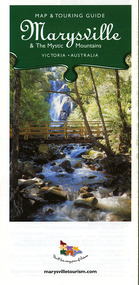
Map (Item) - Map and touring guide, Murrindindi Regional Tourism Association Inc, Marysville & The Mystic Mountains VICTORIA-AUSTRALIA, 08-2002
A fold out map and touring guide of Marysville and the surrounding district published in 2002 by Murrindindi Regional Tourism Association Inc.A fold out map and touring guide of Marysville and the surrounding district published in 2002 by Murrindindi Regional Tourism Association Inc.marysville, victoria, australia, map and touring guide, mystic mountains tourism, the beeches rainforest walk, lake mountain, cambarville, cathedral range state park, the cumberland, abbey green b&b cottages, anastasia fairytale cottage, ashlar cottage b&b, somerled mountain retreat, baree mudbrick cottages, blackwood cottages, camellia cottage, cathedral view b&b, cottage riverside, crossways country inn, dalrymples guest cottages, esa country ministries, hillcrest, keppels hotel motel, kerami house, lomatia lodge, lyell guest cottages, marylands country house, marysville caravan park, marysville holiday cottages, maryton park, melina cottage, moondai farm b&b, mountain lodge marysville, mount cathedral lodge, mystic mountains holiday cottages, nanda binya lodge, rendezvous on murchison, scenic b&b, the hermitage, tower motel, waratah house, willowbank at taggerty, woodlands of narbethong, keppels, lake mountain resort cafe, lanterns at willowbank, mantirri blueberry farm, marysville country bakery, the old woolshed cafe, clearstream olives, uncle fred & aunty val's old style lolly shop, acheron valley alpacas country store & gallery, bruno's art and sculpture garden, country touch, things of sand & stone, willowbank gallery, marysville auto & hardware, marysville newsagency & general store, marysville visitor information centre, narbethong visitor information centre, gallipoli park, keppels lookout, lady talbot drive, steavenson falls, steavenson river, taggerty river, acheron river, black spur trail riding centre, buxton trout farm, lake mountain resort ski hire, lake mountain ski school, marysville district country club, marysville ski centre, narbethong ski hire, rubicon horse riding, country touch tours, murrindindi regional tourism association inc -
 Marysville & District Historical Society
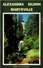
Ephemera (Item) - Visitor's Guide, Shire of Alexandra, ALEXANDRA EILDON MARYSVILLE Visitor's Guide, Unknown
A tourist guide for Alexandra, Eildon and Marysville produced by the Shire of Alexandra.A tourist guide for Alexandra, Eildon and Marysville produced by the Shire of Alexandra.alexandra, eildon, marysville, victoria, australia, tourist guide, steavenson falls, blackwood lodges, marysville hotel motel, the cumberland, gallery restaurant marysville, marysville gallery, cross country ski hire, marylyn guest house, marylands guest house, marysville crafts & gifts, hearts of oak antiques, geoffrey pope & associates, cedron house marysville, amber view holiday lodges marysville, marysville ski hire, lake mountain ski school, fruit salad farm, taggerty general store, arbor green galleries marysville, black spur roadhouse, black spur motel & caravan park, marysville caravan park, the hermitage narbethong, danish coffee garden, maryton park, buxton trout farm, lake mountain outdoor centre marysville, australian bush pioneer's farm, the camel farm and zoo buxton, marysville mountain view horse hire, marysville golf and bowls club, yarrolyn holiday park taggerty, riverland lodge taggerty, beauty spot walk, tree fern gully walk, michaeldene track, keppel track, woods lookout track -
 Marysville & District Historical Society
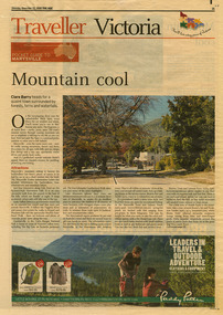
Newspaper (Item) - Newspaper article, The Age, POCKET GUIDE TO MARYSVILLE, 22-11-2008
A newspaper article on Marysville, its local attractions, places to shop and dine, where to stay and ways of traveling to Marysville. This article was published in The Age on Saturday, November 22, 2008.A newspaper article on Marysville, its local attractions, places to shop and dine, where to stay and ways of traveling to Marysville.marysville, victoria, australia, the age, black spur, marysville visitor information centre, steavenson falls, lady talbot drive, taggerty river, keppel falls, phantom falls, beeches rainforest walk, cambarville, yarra ranges national park, the big tree, cumberland walk, lake mountain, steavenson river, acheron river, buxton bait and tackle, marysville trout and salmon ponds, buxton trout and salmon farm, bruno's art and sculpture garden, villa day spa, cathedral view natural therapies, marysville massage, murchison street, village walk, uncle fred & aunty val's old style lolly shop, country touch gallery, manical mechanicals, hidden talent craft gallery, carmyle farm boutique, marysville community market, marysville patisserie, marysville country bakery, fraga's cafe restaurant, terracotta room, marylands country house, the cumberland, mantirri blueberry farm, narbethong, marysville farmers market, the black spur inn, allawah country cottages, barree mud brick cottages -
 Marysville & District Historical Society
Map (Item) - Tourist map, Mystic Mountains Tourism, OFFICIAL VISITORS' MAP MARYSVILLE LAKE MOUNTAIN, Unknown
A visitors' map of Marysville and Lake Mountain produced by Mystic Mountains Tourism for Visit Victoria.A visitors' map of Marysville and Lake Mountain produced by Mystic Mountains Tourism for Visit Victoria.The Marysville and Lake Mountain Visitor Map and Touring Guide has been compiled and/ published by Mystic Mountains Tourism Inc. Copyright./ Production and artwork Graph Attack P/Lmarysville, lake mountain, victoria, australia, visitor's map, official visitors' map marysville lake mountain, buxton, narbethong, taggerty, visit victoria, mystic mountains tourism inc, graph attack p/l, mystic mountains, marysville triangle, marysville visitor information centre, marylands country house, black spur, steavenson falls, lady talbot drive, cambarville, cathedral ranges, wirreanda festival, lake mountain summit walk, summit walk loop, leadbeaters loop, day loop walk, buxton hotel, igloo roadhouse, karmann waters, silverstream b&b cottages, buxton trout and salmon farm, the niche wine bar, buxton post office & general store, choppers buxton roadhouse, woodlands rainforest bungalows, chestnut glade, black spur inn, wombat cottage, abbey lake luxury b&b spa cottages, mystic mountain ski hire & outdoors, pnl 4wdriving, blue views holiday units & ski hire, marapana agistment park & farm stay b&b, danico design, things of sand & stone, mantirri blueberry farm, allawah country cottages, amberview cottages, ashlar cottage b&b, black spur motel & caravan park, blackwood deluxe cottages, blackwood courtyard b&b, dalrymples guest cottages, delderfield, el kanah guest house, fruit salad farm, kerami guest house, keppels hotel, lake mountain-snow gum lodge, lomatia lodge, lyell guest cottages, magnolia house, keppel waters, lyrebird apartments, marysville caravan park, all view spa apartments, riverside cottages, maryton park b&b country cottages, melina cottage, mountain lodge, mystic mountains holiday cottages, nanda binya lodge, rendezvous luxury cottages, scenic b&b motel, the cumberland, south cathedral farm, tower motel, willowbank at taggerty, woodlands rainforest retreat, marysville & district country club inc, mystic mountains ski hire & outdoors, rubicon valley horse riding, marysville trout and salmon ponds, gallipoli park, keppels lookout, cambarville-yarra ranges national park, lake mountain-yarra ranges national park, lady talbot drive-yarra ranges national park, cathedral range state park, steavenson river, taggerty river, acheron river, lake mountain alpine resort, bruno's art and sculpture garden, manical mechanicals, uncle fred & aunty val's old style lolly shop, carmyle farm boutique, crossways historic country inn, fraga's, gilberts restaurant, heights licensed bistro, the old woolshed cafe, cathedral view natural therapies, crystal journey -
 Marysville & District Historical Society
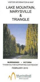
Map (Item) - Tourist map, Murrindindi Shire Council, VISITOR INFORMATION & MAP LAKE MOUNTAIN, MARYSVILLE & TRIANGLE, 02-2010
A visitor information map for Lake Mountain, Marysville and the local district produced by the Murrindindi Shire Council in February 2010. This information guide and map was produced after the 2009 Black Saturday bushfires destroyed most of the township of Marysville.A visitor information map for Lake Mountain, Marysville and the local district produced by the Murrindindi Shire Council in February 2010.Murrindindi Shire Council has made every effort to ensure the information provided at the time/ of printing is correct, but accepts no responsibility for an inaccuracies or omissions.lake mountain, marysville, victoria, australia, visitor information & map, murrindindi shire council, big 4 holiday park taggerty, black spur inn, black spur motel & caravan park, bush creek buddha, buxton hotel motel, cathedral valley farm, chestnut glade, crossways historic country inn, delderfield luxury b&b, kingbilli country estate, marapana agistment park & farm stay b&b, maryton park b&b, pinjarra gardens, sarsens rest, silverstream b&b, tower motel, willowbank at taggerty, wombat cottage, woodlands rainforest retreat, buxton general store and post office, buxton zoo nursery, cathedral view natural therapies, country touch, cross country ski hire, foodworks, highwood health retreat, lake mountain ski hire, lit & beyond, lj hooker, maroondah outdoor equipment/bait & tackle, marysville medical centre, marysville patisserie, marysville ski centre, marysville triangle real estate, marysville visitor information centre, mystic mountains ski hire/outdoors, pat's hairdressing, penni lanes country wares, plant's by shelian -
 Eltham District Historical Society Inc
Photograph, Peter Bassett-Smith, Upper Yarra Dam, Spring Tour, 22 Oct 1995, 22/10/1995
EXPLORING THE UPPER YARRA (Newsletter No. 105, November 1995, by Bettina Woodburn) We enjoyed the Spring Excursion, this year "Exploring the Upper Yarra" - in spite of the constant rain and the countryside under the cloud cover, especially in the valleys, being mainly shiny shades of green. The occasional fields of buttercups, clumps of arum lilies and splendid rhododendron and other flowering bushes became very special. The Cobb and Co coach was warm and a cosy retreat as we zig-zagged on the highways and byways to glimpse the Yarra River, upstream and down, its secret places, and particularly the many bridges. Russell excelled as 'Poet Laureate', reading from Dacre Smyth's book. This 1979 publication includes paintings of all the bridges along the river with poems and brief descriptions of each one. Some of the bridges are in out of the way places and are not very well known. We looked forward to hearing the poetry as much as seeing the ' constructions'…Big Pat (was he short or tall, lean or fat? He did win the two hundred pound reward for discovering gold and had the creek named after him), about the 'Eddies'?, and the disliked 'meccano' bridge in Warburton, etc. etc. The hot roast lunch in the old Reefton Hotel was also most welcome. It was easy to imagine it peopled by miners and early settlers. Starting by crossing the new (1974) concrete bridge at Warrandyte we headed through Wonga Park with views to the Christmas Hills and to the escarpment of the Yering Gorge, which causes flood waters to back up through the Yarra Glen plain, so avoiding disasters downstream. At the end of a long driveway we found the wooden, privately owned Henley Bridge (1935 after the 1934 floods). This facilitates access to different parts of Henley Farm and to Lilydale. Everard Park, named after Blanche Shallard's father, a State Member for 17 years, below the Highway Yarra crossing was in need of care. It is 10 miles from Yarra Glen by road but, as "Yarra Marra” canoeists well know, 32 winding miles down by water. After more delightful countryside scenes we joined the Warburton Highway at Woori Yallock. From the old Railway Station at Launching Place the Centennial Trail for walkers, cyclists and ' horse riders has replaced the rails. The line from Lilydale was opened in 1901, and the last diesel freight train ran to Warburton in 1965. It continued to rain as we had morning tea in Warburton in a shelter between footbridges. From here we continued upstream past the Bridge to O'Shannasy Lodge and Reservoir, Starvation Creek, and the Peninsular tunnel (miners dug it as at Pound Bend) which we visited (scrambling down those steps!) on our return after lunch. Our furthermost point was the Upper Yarra Dam Reserve (and vast catchment area). Finished in 1957 after ten years work and 100 years after Yan Yean, it supplies much of Melbourne's water. After crossing the 30m Launching Place Bridge to the Eltham side of the Yarra and Healesville, we saw in the distance the Yarra Glen Timber Trestle Bridge over the river flats "the longest for years in the land it was said!" Harry's dream of "better weather over the Divide" unfortunately didn't come true, but I'm sure we 36 members will retain happy memories of a day that was wet and green and filled with Bridges. Bettina Woodburn - October 1995 Record of the Society's history of activities - Spring 1995 excursionColour photographactivities, upper yarra dam, 1995, peter bassett-smith