Showing 3377 items matching "glenferrie"
-
 St Patrick's Old Collegians Association (SPOCA)
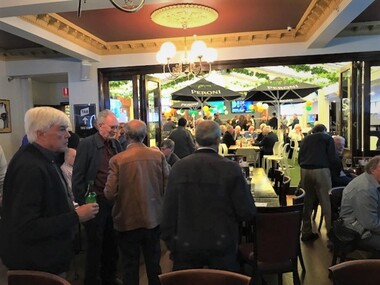
Photograph - SPOCA, Class Reunions, 55 Years since Closure, Glenferrie Hotel, Feb2023
-
 Kew Historical Society Inc
Document - Urban Planning Document, City of Kew, City of Kew : Minimum Size of Allotment Required, 1945-1955
A document outlining the relevant by-laws produced by the City Of Kew to regulate the minimum size of allotments in Barkers Road, Burke Road, Cotham Road, Glenferrie Road and Studley Park Road, as well as in other streets more generally. The by-laws specify the size of allotments in which single unit dwellings, attached houses and maisonettes, and flats could be built. In the ‘main streets’ a minimum land area for single unit dwellings was 8,100 square feet, with an average frontage of 60’ and a depth of 135’. In other streets this was reduced to an overall size of 6,250 square feet, with an average dimensions of 50’ x 125’. In specifying the land area required by flats, different sizes were regulated for the construction of between two and six flats. Six flats at the time when the regulations were passed must have been the upper limit permitted. Understanding the size of land listed in imperial measurements can be a challenge. Within Australia, the so-called quarter acre block was approximately 11,000 square feet. Those specified in the by-laws would appear to be smaller. The document was pasted on the reverse of a subdivision plan in the collection.This is a rare (undated) document produced by the City of Kew defining how subdivision within the municipality should occur. The document was created to constrain unbridled speculation in subdivisions in the various parts of Kew and East Kew.Undated typed document, issued by the City of Kew (1921-1994) indicating the minimum size of allotment required in Barkers Road, Burke Road, Cotham Road, Glenferrie Road and Studley Park Road. The document is mounted on board and waterstained. It was presumably used by a real estate agent. [Formerly catalogued as MAP.0066].city of kew - by-laws and regulations, subdivisions - kew - studley park -
 Robin Boyd Foundation
Slide, Robin Boyd
Colour slide in a mount. Anselm', Haddon House, 4 Glenferrie Street, Caulfield, Victoria, Australia, 1906. (Architect: Robert Haddon.)Made in Australia / Encircled 49 (Handwritten) / G6 (Handwritten)melbourne, slide -
 St Patrick's Old Collegians Association (SPOCA)
Photograph - SPOCA, Class Reunions, 1968
-
 Clunes Museum
Photograph, 1939
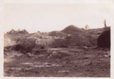
THIS PHOTOGRAPH IS OF PORT PHILLIP MINE CLUNES. VIEW OF MULLOCK HEAPS.BLACK AND WHITE PHOTOGRAPH OF MULLOCK HEAPS OF PORT PHILLIP MINE AT CLUNES.ON REVERSE: HANDWRITTEN IN BLUE BIRO "MULLOCK HEAPS CLUNES 1939" ON REVERSE: HANDWRITTEN IN LEAD PENCIL "15" AND "20"" ON REVERSE: PURPLE STAMPED "ALLAN H. MANSELL CHEMIST, 213 GLENFERRIE ROAD GLENFERRIE"local history, photography, photographs, mining -
 Kew Historical Society Inc
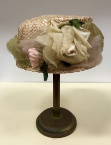
Headwear - Cream Straw & Silk Hat, L’Estelle, 1930s
In 1930, the business 'L'Estelle' is registered as operating at 107B Glenferrie Road, Glenferrie (Commonwealth of Australia Gazette No.99 (12 November 1930)The Kew Historical Society’s fashion and design collection is comprised of costumes, hats, shoes and personal accessories. Many of these items were purchased or handmade in Victoria; some locally in Kew. The extensive hat collection comprises items dating from the 1860s to the 1970s. While most of the hats in the collection were created by milliners for women, there are a number of early and important men’s hats in the collection. The headwear collection is particularly significant in that it includes the work of notable Australian and international milliners.Plain straw woman’s hat with a narrow brim covered with pale green and pink silk roses and net. Label: L’Estellel'estelle, women's clothing -- hats, headwear, straw hats -- 1930s -
 Kew Historical Society Inc
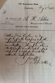
Letter - AH Adler, Pharmaceutical Chemist, 1916
Arthur Henry Miers played for cricket, football and baseball teams in Kew for a number of decades in the first half of the twentieth century. He was born on 22 November 1901, the son of Rodolph Theophilus Miers (1874-1951) and Margaret Frances (Margaretta) Fry (1875-1958). He had two brothers, Rodolph Cecil Miers (1904-80) and Charles Wilfred Miers (1906-88), and a sister Marjorie Elizabeth Miers (1911-84). Arthur Miers died in Kew on 25 January 1966, and after his body was cremated, his body was interred in the Mausoleum of Boroondara General (Kew) Cemetery.Testimonial from AH Adler, Pharmaceutical Chemist; 145 Glenferrie Rd; Hawthorn; testifying to employment of A Miers; dated 1 May 1916arthur henry miers, ah adler pharmaceutical chemist -- glenferrie road -- hawthorn (vic.) -
 Kew Historical Society Inc
Photograph - Victorian Villa, High Street, c.1922
Subdivision plans are historically important documents used as evidence of the growth of suburbs in Australia. They frequently provide information about when the land was sold on which a built structure was subsequently constructed as well as evidence relating to surveyors and real estate and financial agents. The numerous subdivision plans in the Kew Historical Society's collection represent working documents, ranging from the initial sketches made in planning a subdivision to printed plans on which auctioneers or agents listed the prices for which individual lots were sold. In a number of cases, the reverse of a subdivision plan in the collection includes a photograph of a house that was also for sale by the agent. These photographs provide significant heritage information relating house design and decoration, fencing and household gardens.An old inscription on this photograph identifies it as ‘an elegant timber villa in High Street. It occupied part of Lot 91, bought by Edward Glyn in the land sale of 16th October 1851, and run as a flower farm’. The subdivision called the ‘Flower Farm Estate’ in East Kew occurred in 1922. [The subdivision plan is on the reverse of this photo.] The Estate included 61 lots on either side of Boorool Road between High Street and Harp Road. In the MMBW Detail Plan 2017 of 1926, a number of these new villas had already been built. Matching houses with MMBW maps can always be a challenge, however if this house was near the corner of Boorool Road and High Street, it seems to fit the profile of a house called ‘Maxton’ (demolished).Photographer's name on photograph, lower right, and stamp on mount lower right: "A. Aberline, Glenferrie".houses - maxton - high street - kew (vic.), violet farm estate, subdivisions - kew (vic.) -
 Kew Historical Society Inc
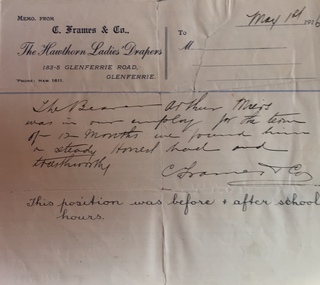
Letter - Frames & Co, The Hawthorn Ladies Drapers, 1916
Arthur Henry Miers played for cricket, football and baseball teams in Kew for a number of decades in the first half of the twentieth century. He was born on 22 November 1901, the son of Rodolph Theophilus Miers (1874-1951) and Margaret Frances (Margaretta) Fry (1875-1958). He had two brothers, Rodolph Cecil Miers (1904-80) and Charles Wilfred Miers (1906-88), and a sister Marjorie Elizabeth Miers (1911-84). Arthur Miers died in Kew on 25 January 1966, and after his body was cremated, his body was interred in the Mausoleum of Boroondara General (Kew) Cemetery.Original handwritten certificate on letterhead from employer testifying to Arthur Miers employment with the company at 183-5 Glenferrie Rd, Hawthorn, dated 1 May 1916arthur henry miers, frames & co -- hawthorn -
 Federation University Historical Collection
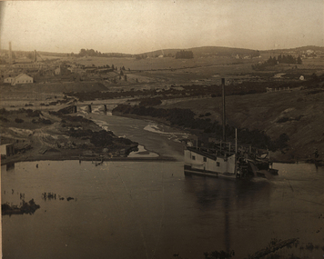
Photograph, Gold Dredge
Black and white mounted photograph of a dedge floating on a body of water which has a creek flowing into it, and rolling hills in the background. The buildings associated with a mine or factory are shown on the top left hand side. Signed "Martin ?ish Victoria St" verso "R.H. Brooke, "Callantina Villa", Glenferrie Rd Sthdredge, dredging, mining, river, callantina villa, gold mining -
 University of Melbourne, Burnley Campus Archives
Map, Drainage & Contours City of Hawthorn, c. 1970
Copy of map with some coloured and pencil annotations. Scale 1:2000. Marked "2". Area bounded by Glenferrie Road, Power Street, Barkers Road, Burwood Roadhawthorn, glenferrie sports ground, grace park, contours -
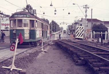 Melbourne Tram Museum
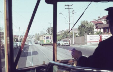
Slide, Keith Caldwell, March 1968?
Agfa colour blue white plastic mount slide, photo by Keith Caldwell of W2 605 or 625, southbound in Glenferrie Road, at the Kooyong level crossing. Glenferrie Road is being reconstructed with the north bound track in a temporary location. Tram has advert for Kenric clothes and Exide? batteries. The night watchman is watching the tram. His cabin is behind him.. The tram is showing (incorrectly) Kew Cotham Road destination. This is a Camberwell Depot tram bound for Malvern Town Hall assisting movement of School children in Glenferrie Road in the afternoon. Note the Camberwell Run number in the driver cab window. On the north bound track is possibly a SW6. Slide undated - c1968?trams, tramways, glenferrie rd, kooyong, level crossings, temporary track, w2 class, trackwork, kew- cotham road, tram 605, tram 625 -
 Vision Australia
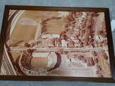
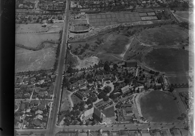
Photograph - Image, Association for the Blind offices in Kooyong aerial view
Aerial view of Kooyong. The Kooyong Tennis Centre, Glenferrie Road, train station, Talbot Crescent, Monash Freeway and parklands are clearly visible. Few trees are lining the roadway around the sporting fields, the Glenferrie Road building has not expanded and the Blind Cricket pavilion is not yet built. Aerial photograph in brown frame.association for the blind, kooyong tennis centre -
 Vision Australia
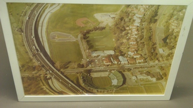
Photograph - Image, Association for the Blind offices in Kooyong aerial view
Aerial view of Kooyong. The Kooyong Tennis Centre, Glenferrie Road, train station, Talbot Crescent, Monash Freeway and parklands are clearly visible. Few trees are lining the roadway around the sporting fields, the Glenferrie Road building has not expanded and the Blind Cricket pavilion is not yet built. Aerial photograph in white frameassociation for the blind, kooyong tennis centre -
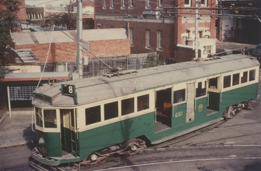 Ballarat Tramway Museum
Photograph - Colour Print, Clive Gibson, 1960's
Yields information about a Melbourne tramcar that was to be later collected by the Museum, when it was operating in Melbourne.Colour print of MMTB W3 661 entering Malvern Depot from Glenferrie Road, 1960's? Photo Clive Gibson. Tram has route No. 8 showing. Printed on Kodak Paper.On rear in ink "On behalf of Clive M Gibson & Ron Scholten"trams, tramways, w class trams, malvern depot, tram 661 -
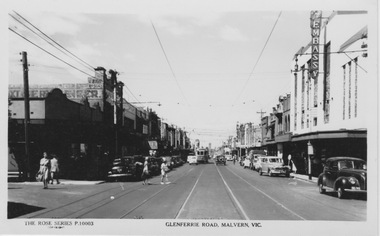 Melbourne Tram Museum
Photograph - M&MTB W class tram in Glenferrie Rd, Malvern, Rose Stereograph Co, 1950s
The photograph shows an unidentified Melbourne and Metropolitan Tramways Board W class tram in Glenferrie Rd, possibly passing the tram depot. The tramcar is in the mid ground and Glenferrie Rd is lined with retail shop verandahs on the ground floor and the Embassy Theatre on the right. A large number of motor cars are seen along the roadway and adult pedestrians in summer clothes.Yields information about Glenferries Rd and M&MTBBlack and white photograph with writing on the rear.Printed Post Card by Rose Stereograph, Armadale glenferrie rd, melbourne and metropolitan tramways board, w class, retail shop verandahs, embassy theatre, tram depot -
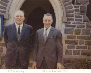 Lakes Entrance Historical Society
Photograph - Alf Sandburg and Charles Hancock Senior, 1966
both of Lakes Entrance taken at a church doorway believed to be St Georges Glenferrie Road Malvern VictoriaColour photograph showing Alf Sandburg of Bellevue Guest House with Charles Hancock Seniorreligion, social history -
University of Melbourne, Burnley Campus Archives
Photograph - Black and white print, Aerial View of Burnley Campus, 1977
Framed enlargements. (A) Burnley College and surrounding suburbs showing the nearly constructed Freeway, the College in the bend of the Yarra River, Glenferrie Road to the East Swan Street to the North. (B) Enlargement of (A) showing detail of Burnley College.burnley college, suburbs, freeway, yarra river, glenferrie road, east swan street, aerial view -
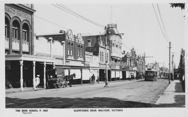
 Melbourne Tram Museum
Photograph - M&MTB W class 255 in Glenferrie Rd, Malvern, Rose Stereograph Co, 1920s
The photograph shows Melbourne and Metropolitan Tramways Board W class tram 255 in Glenferrie Rd showing destination Victoria Bridge. The tramcar is in the mid ground and Glenferrie Rd is lined with retail shop verandahs on the ground floor and ornate second floor residences or workshops. Span poles hold the tramway overhead and several early motor cars are seen along the roadway.Yields information about Glenferries Rd and M&MTBBlack and white photograph with writing on the rear.Printed Post Card by Rose Stereograph, Armadale with ink stamp reading "K J Magor No." glenferrie rd, melbourne and metropolitan tramways board, w class, tram 255, victoria bridge, span poles, retail shop verandahs -
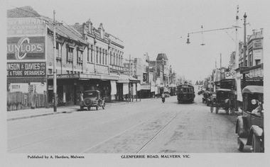
 Melbourne Tram Museum
Photograph - PMTT tram 26 Glenferrie Rd, Malvern, Rose Stereograph Co, 1910s
The photograph shows Prahran and Malvern Tramways Trust tram 26 in Glenferrie Rd on route 1, possibly just south of the tram depot. The tramcar is in the mid ground and Glenferrie Rd is lined with retail shop verandahs on the ground floor and ornate second floor residences or workshops. Central poles hold the tramway overhead and several horse drawn carts are seen along the roadway.Yields information about Glenferries Rd and PMTTBlack and white photograph with writing on the rear.Printed Post Card by Rose Stereograph, Armadale with ink stamp reading "K J Magor No." prahran and malvern tramways trust, glenferrie rd, tram depot, central poles, route 1, horse drawn carts -
 Melbourne Tram Museum
Photograph - Digital Image, Kevin O'Reilly, looking south over the Scotch College complex, Late 1930's to mid 1940's
Image from CD (Compact Diskette for use in computers) - see Reg Item 135. Image titled "Scotch" on CD, of looking south over the eastern part of Scotch College complex with Glenferrie Road, Hawthorn on the left hand side of the photograph. The Kooyong Stadium (Tennis) constructed in 1927 now shows the new extended Northern stand added in 1934. In the top left of the photograph is the Kooyong Railway Station. A tram can be seen southbound in Glenferrie Road, adjacent to the college. late 1930's to mid 1940's trams, tramways, kooyong, hawthorn, glenferrie rd, kooyong tennis courts, scotch college -
Glen Eira Historical Society
Plan - Yeshivah & Beth Rivkah College
This file contains a set (incomplete) of 7 architectural drawings prepared by architects Synman Justin Balek and Best Overend and Partners - Existing site and Master Plan o - Primary School Administration and Community Facility - Synagogue Refurbishment 2 - Multipurpose Hall 3 - Glenferrie Property – Refurbishment of Residence 5 – Glenferrie Property - New Kindergarten 6 - Another Property Refurbishment of Residence 7school, plans, saint kilda east, independent school, architects, hotham street, yeshivah and beth rivkah college, synman justin balek, balaclava road, best overend & partners -
 Kew Historical Society Inc
Slide - 'Comaques', 896 Glenferrie Road, 1979
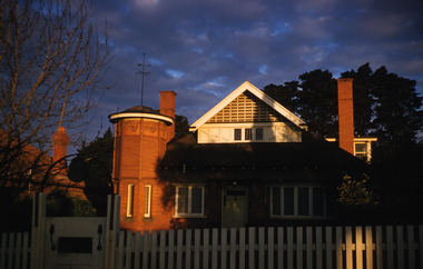
One of a group of slides taken by members of the Society of built heritage in Kew in 1979-80. The selection of subject matter reflects the priorities of the period. The colour of some slides has degraded.The slides represent a snapshot in time of built architecture in Kew, much of which has changed in the forty-plus period since they were created.Colour positive transparency (slide) of 'Comaques', 896 Glenferrie Road, Kew. The photograph shows the house without the subsequent repainting which has diminished its heritage value. The house was built c.1891 for the architect Alfred White.comaques, historic houses -- kew (vic.), glenferrie road -- kew (vic.) -
 Bendigo Historical Society Inc.
Postcard - ROY AND DORIS KELLY COLLECTION: VERCLAU, 1900-1920
Postcard, B&W image of a tiled roof, brick house behind a picket fence and front lawn and flower garden. A woman stands on the front verandah and a man stands to the right of the steps up to the house. Front gate from a footpath at lower right. On the back handwritten in ink ' 1916-1917 Season's Greetings from "Verclau" Also an oval shaped stamp inside reads 'A Aberline 138 Glenferrie Rd Glenferrie' 'Verclau' is the name of the house in Stevenson St, Kew, Melbourne. According to a press death notice a family called GUY was living there in 1917.postcard, photograph, postcard, verclau, house, stevenson st, kew -
 Melbourne Tram Museum
Slide, Keith Caldwell, 25/04/1964 12:00:00 AM
Agfa colour slide, blue / white plastic mount, photo by Keith Caldwell of the view from a Y1 tram in Riversdale Road, just east of Glenferrie Road with Y1 612 (city) coming the other way. 25/4/1964In ink "View from T1 25.4.64"trams, tramways, y1 class, riversdale rd, tram 612 -
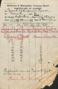 Melbourne Tram Museum
Document - Form/s, Melbourne & Metropolitan Tramways Board (MMTB), "Particulars of Loading", 1933
Form 104 - titled "Particulars of Loading" - giving tramcar passenger capacity, location, date, counted by, time, tram number, destination, and passengers - on Toorak line, Up. At Toorak & Glenferrie Rds Dated Sat 30 Dec & Mon 1 Januarytrams, tramways, mmtb, tramcars, passenger services, inspectors, reports -
Kew Historical Society Inc
Clothing - Cream Silk Knickers, Ivy Fields, 1940s
In 1938 Ivy Field’s business was located at 242 Riversdale Road, Hawthorn. There is a newspaper report of a robbery at Miss Ivy Field’s shop in Glenferrie Road, Hawthorn in 1949.Woman’s silk knickers with appliqued silk bows at the front. The panties do not have ties or elastic at the waist and are ‘done up’ by button on the side of one leg.Label: ‘Ivy Fields, Hawthorn 207’women's clothing, underwear, knickers, ivy fields - 242 glenferrie road - hawthorn (vic), fashion and textiles collection - kew historical society -
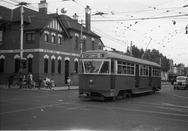 Melbourne Tram Museum
Negative, Wal Jack, 9/02/1951 12:00:00 AM
Black and white negative, by Wal Jack, of PCC 980, northbound bound in Glenferrie Road at High Street with the destination of Kew Cotham Road. The Bank was replaced by a more modern looking building during the 1970's. In the background is the ES&A bank on the corner. Jane Nigro advised 9/9/2020: "1907 Photo of the E. S. & A. Bank on the corner of High Street and Glenferrie Road, Malvern. In 1885 land on corner of Glenferrie Road & High St. (40' x 150') was purchased by E.S. & A. Bank. A condition of sale was that the bank erect on the land a 'substantial brick building to be used as a branch bank', within 24 months. The E.S. & A. Bank, single-storey four roomed brick, was built in 1888. The first manager was Frederick Leonard. In 1907 a second storey, including residential quarters for the manager, was added to bank at a cost of £1400.The Bank was demolished in 1958-9and replaced with present building."trams, tramways, pcc class, glenferrie road, route 69, kew- cotham rd, tram 980 -
Port Melbourne Historical & Preservation Society
Book, Terry Keenan, "Once were Champions", 2017
"Once were Champions" Book written by Terry Keenan on the first 50 years of the Port Melbourne Cricket Club. Blue and white cover and picture of cricket match at Glenferrie Oval. Logo of Port Melbourne Cricket Club at top with church buildings in background.The first fifty years of the Port Melbourne Cricket Club.sport - cricket, port melbourne cricket club, terry keenan -
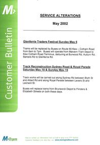 Melbourne Tram Museum
Poster, M>Tram, "Service Alterations May 2002", May. 2002
Poster - A3 size heavy paper, published by M>Tram titled "Service Alterations May 2002" for the Glenferrie Traders Festival Sunday May 5 and Track Reconstruction in Sydney Road and Royal Parade, Sat May 18 and Sunday May 19.trams, tramways, m>tram, services, glenferrie rd, royal parade, sydney rd, trackwork