Showing 347 items matching "golf courses"
-
 Heidelberg Golf Club
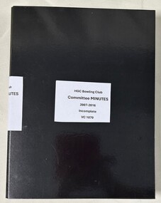
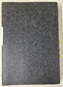
Administrative record - Minute Book, Heidelberg Golf Club Bowling Club, Heidelberg Golf Club Bowling Club: Committee Minutes 2007-2016, 2007-2016
... to walk the hills of the golf course to have a sporting... to walk the hills of the golf course to have a sporting ...Minutes of the Heidelberg Golf Club Bowling Club: 2007-2016. The Bowling Club was formed in 1958 to enable members no longer able to walk the hills of the golf course to have a sporting involvement with the club. This folder contains an incomplete set of minutes.An incomplete set of minutes of the Bowling Club at HGC.Black folder containing typed minutes. heidelberg golf club bowling club, committee minutes -
 Heidelberg Golf Club
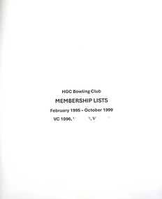
Document - Membership lists, Heidelberg Golf Club Bowling Club, Heidelberg Golf Club Bowling Club. Membership lists 1995-2016, 1992-2016
... of the golf course to have a sporting involvement with the club. ... of the golf course to have a sporting involvement with the club ...Heidelberg Golf Club Bowling Club. Membership lists 1992-2016. Membership lists over 30 years. The Bowling Club was formed in 1958 to enable members no longer able to walk the hills of the golf course to have a sporting involvement with the club. A small collection of printed membership lists, various formatsheidelberg golf club bowling club, membership lists -
 Heidelberg Golf Club
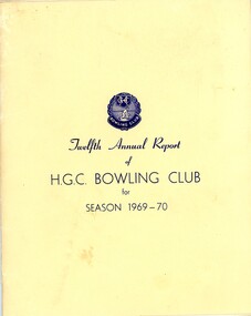
Booklet - Annual Report, Heidelberg Golf Club Bowling Club, Heidelberg Golf Club Bowling Club: Twelfth Annual Report of H.G.C. Bowling Club for season 1969-70, 29/04/1970
... of the golf course to have a sporting involvement with the club.... of the golf course to have a sporting involvement with the club ...Heidelberg Golf Club Bowling Club: Twelfth Annual Report of H.G.C. Bowling Club for season 1969-70. The Bowling Club was formed in 1958 to enable members no longer able to walk the hills of the golf course to have a sporting involvement with the club.Annual reports found in this collection begin in 1959-60. Numbering of Annual Reports begins with the Eighth report in 1965-66.7 page booklet, typed and copied report in printed manilla cover. Includes list of members and loose Notice of Meeting.annual reports, financial reports, heidelberg golf club bowling club -
 Heidelberg Golf Club
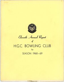
Booklet - Annual Report, Heidelberg Golf Club Bowling Club, Heidelberg Golf Club Bowling Club: Eleventh Annual Report of H.G.C. Bowling Club for season 1968-69, 23/04/1969
... of the golf course to have a sporting involvement with the club.... of the golf course to have a sporting involvement with the club ...Heidelberg Golf Club Bowling Club: Eleventh Annual Report of H.G.C. Bowling Club for season 1968-69. The Bowling Club was formed in 1958 to enable members no longer able to walk the hills of the golf course to have a sporting involvement with the club.Annual reports found in this collection begin in 1959-60. Numbering of Annual Reports begins with the Eighth report in 1965-66.7 page booklet, typed and copied report in printed manilla cover. annual reports, financial reports, heidelberg golf club bowling club -
 Heidelberg Golf Club
Administrative record - Financial records, Heidelberg Golf Club Bowling Club, Heidelberg Golf Club Bowling Club: Financial records 2014-2016, 2014-2016
... no longer able to walk the hills of the golf course to have... no longer able to walk the hills of the golf course to have ...Heidelberg Golf Club Bowling Club: Financial records 2014-2016. The Bowling Club was formed in 1958 to enable members no longer able to walk the hills of the golf course to have a sporting involvement with the club. This folder contains invoices and cheque payment details.White binder containing invoices and cheque payment details.heidelberg golf club bowling club, financial records, pat buckley -
 Eltham District Historical Society Inc
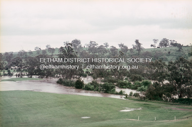
Slide, Floodwater, west from Clubhouse of Rosanna Golf Club, Lower Plenty, November 1971, 1971
... the level of the Plenty River floods onto the golf course. .... Here the level of the Plenty River floods onto the golf course ...Many parts of Melbourne flooded including Rosanna Golf Club, Lower Plenty in Novembere 1971. Many surburban roads, including the new south-eastern freeway were cut by flood waters. Here the level of the Plenty River floods onto the golf course. 35 mm colour positive transparency Mount - Agfacolor Service (Blue)floods, lower plenty, rosanna golf club, flooding, plenty river -
 Heidelberg Golf Club
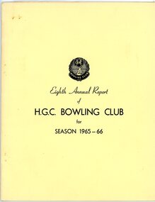
Booklet - Annual Report, Heidelberg Golf Club Bowling Club, Heidelberg Golf Club Bowling Club: Eighth Annual Report of H.G.C. Bowling Club for season 1965-66, 27/04/1966
... no longer able to walk the hills of the golf course to have... to walk the hills of the golf course to have a sporting ...Heidelberg Golf Club Bowling Club: Eighth Annual Report of H.G.C. Bowling Club for season 1965-66. Includes list of members. The Bowling Club was formed in 1958 to enable members no longer able to walk the hills of the golf course to have a sporting involvement with the club.Annual reports found in this collection begin in 1959-60. Numbering of Annual Reports begins with the Eighth report in 1965-667 page booklet, typed and copied report in printed manilla cover. Includes list of members and loose Notice of Meeting.annual reports, financial reports, heidelberg golf club bowling club -
 Heidelberg Golf Club
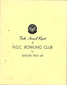
Booklet - Annual Report, Heidelberg Golf Club Bowling Club, Heidelberg Golf Club Bowling Club: Tenth Annual Report of H.G.C. Bowling Club for season 1967-68, 24/04/1968
... no longer able to walk the hills of the golf course to have... to walk the hills of the golf course to have a sporting ...Heidelberg Golf Club Bowling Club: Tenth Annual Report of H.G.C. Bowling Club for season 1967-68. Includes list of members. The Bowling Club was formed in 1958 to enable members no longer able to walk the hills of the golf course to have a sporting involvement with the club.Annual reports found in this collection begin in 1959-60. Numbering of Annual Reports begins with the Eighth report in 1965-66.6 page booklet, typed and copied report in printed manilla cover. Includes list of members and loose Notice of Meeting and a second copy of report.annual reports, financial reports, heidelberg golf club bowling club -
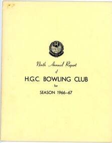 Heidelberg Golf Club
Booklet - Annual Report, Heidelberg Golf Club Bowling Club, Heidelberg Golf Club Bowling Club: Ninth Annual Report of H.G.C. Bowling Club for season 1966-67, 26/04/1967
... no longer able to walk the hills of the golf course to have... to walk the hills of the golf course to have a sporting ...Heidelberg Golf Club Bowling Club: Ninth Annual Report of H.G.C. Bowling Club for season 1966-67. Includes list of members. The Bowling Club was formed in 1958 to enable members no longer able to walk the hills of the golf course to have a sporting involvement with the club.Annual reports found in this collection begin in 1959-60. Numbering of Annual Reports begins with the Eighth report in 1965-66.7 page booklet, typed and copied report in printed manilla cover.annual reports, financial reports, heidelberg golf club bowling club -
 Heidelberg Golf Club
Administrative record - Correspondence, Heidelberg Golf Club Bowling Club, Heidelberg Golf Club Bowling Club: General correspondence 2008-2011, 2008-2011
... members no longer able to walk the hills of the golf course... members no longer able to walk the hills of the golf course ...Correspondence file of the Heidelberg Golf Club Bowling Club: 2008-2011. The Bowling Club was formed in 1958 to enable members no longer able to walk the hills of the golf course to have a sporting involvement with the club. This folder contains a set of correspondence, mainly on the maintenance of the bowls facility.Black arch file binder containing typed and handwritten documents.heidelberg golf club bowling club, correspondence -
 Heidelberg Golf Club
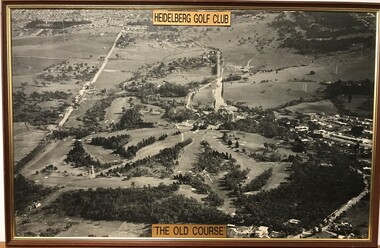
Photograph - Framed Photograph, Heidelberg Golf Club: The old course, 1966c
... Heidelberg Golf Club: The old course...An aerial photograph of the Heidelberg Golf Course, around..."Heidelberg Golf Club" "The old course"... An aerial photograph of the Heidelberg Golf Course, around 1966 ...An aerial photograph of the Heidelberg Golf Course, around 1966 (this date is taken from the road work to build the new bridge over the Plenty River). Known as the 'old course' it was designed by Harry Alexander and was in play until a redesign of the course in 1968. The clubhouse is in top centre of photograph.One of several aerial photogrphs showing the layout of the Heidelberg Golf CourseLarge Black and white aerial photograph, timber frame. Brass plaque top and bottom."Heidelberg Golf Club" "The old course"heidelberg golf club, old course -
 Kew Historical Society Inc
Photograph - Yarra River, Kew, 1925
... of cattle until the land was subdivided or created into golf courses... was subdivided or created into golf courses during the twentieth century ...Henry Beater Christian (1886-1962) , was a descendant of one of the earliest settler families in Kew. Employed at the Kew Asylum as a 'public servant', he was a skilled amateur photographer, photographing numerous scenes in Kew and on his travels around Victoria. The majority of his photographs date from 1916 to 1929. His finest photographs are housed in two photograph albums. Digital copy of a photograph from page 3 of the 47-page photograph album containing 261 gelatinous silver images, loaned by Diane Washfold with permission given to digitise and hold a copy in our collection. A photograph of a stretch of the Yarra River at Kew. From the 1840s, at the Crown Land Sales, lots adjacent to the river were sold and developed as dairy farms, hence the presence of cattle until the land was subdivided or created into golf courses during the twentieth century. "Yarra Rvr / Kew / 1925"henry beater christian (1886-1962), landscape photography, kew (vic.) — yarra river, christian-washfold collection, photograph albums, dairying -- kew (vic.) -
 Wodonga & District Historical Society Inc
Plaque - Wodonga Golf Club Plaque
... , built in 1946. The club house and the golf course were extended.... The club house and the golf course were extended in 1956 ...A commemorative plaque from the old Wodonga Golf House, built in 1946. The club house and the golf course were extended in 1956 to the area of Belvoir Park. It was demolished in 1987 to make room for the new Hume Highway. This plaque was salvaged from the club house building before demolition. This item has a strong link to the local and sporting history of Wodonga.A wooden plaque with engraved metal plate depicting a male golfer attached. gold, sport, leisure, entertainment, wodonga, wodonga golf club -
 City of Kingston
Photograph - Black and white, 5 January 1984
... , reserves and golf courses...., reserves and golf courses. This aerial image covers a diverse ...Moorabbin, Cheltenham and Highett are suburbs in the City of Kingston with a diverse mix of development and zoning. The market gardens, farms and paddocks have gradually been sub-divided into housing and industrial estates and associated infrastructure such as schools and shopping facilities. The area includes many parks, reserves and golf courses.This aerial image covers a diverse section of the City of Kingston, taking in the suburbs of Cheltenham, Moorabbin, Beaumaris and Highett. By 1984, the market gardens of the district have been replaced by housing and factories. The Gas and Fuel state-of-the-art Scientific Services Department is visible on Nepean Highway Highett. The CSIRO Highett site can also be seen. Both sites have now been demolished and have undergone remediation. The Southland site is visible and yet to be redeveloped by Westfield. This image portrays the diversity of development in the City of Kingston with a mixture of green spaces, housing and commercial and industrial features.Aerial photograph of Cheltenham, Beaumaris, Moorabbin and Highett within the City of Kingston. The area depicted in the 1984 aerial view includes Eden Street and Edward Street, Cheltenham (top left), Weatherall Road and Reserve Road, Cheltenham/Beaumaris (top right), Turner Road and Chesterville Road, Moorabbin (bottom left), Nepean Highway (left section), Graham Road and Middleton Street, Highett (bottom right). A large section of this image includes Cheltenham Park and Victoria Golf Club.White text: 3831-219 Lens information [indecipherable] RINGWOOD M/S 7922-3 RUN 15 Clockface image 5,300' ASL VIC DLS© 5-1-84cheltenham, highett, industrialisation, urbanisation, moorabbin, beaumaris -
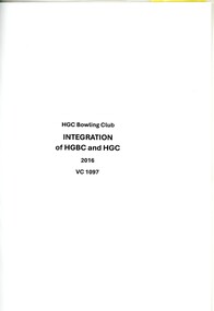 Heidelberg Golf Club
Document, Heidelberg Golf Club Bowling Club, Heidelberg Golf Club Bowling Club. Integration 2016, 2016
... to walk the hills of the golf course to have a sporting... to walk the hills of the golf course to have a sporting ...Heidelberg Golf Club Bowling Club. Integration 2016. A collection of documents relating to the merge (integration) of Bowling Club into the management of Heidelberg Golf Club. The Bowling Club was formed in 1958 to enable members no longer able to walk the hills of the golf course to have a sporting involvement with the club. A collection of documentsheidelberg golf club bowling club, integration, heidelberg golf club -
 Heidelberg Golf Club
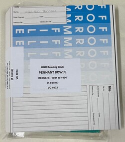
Administrative record - Book, Heidelberg Golf Club Bowling Club, Heidelberg Golf Club Bowling Club: Pennant results 1981-1996, 1981-1996
... Pennant results for the Heidelberg Golf Club Bowling Club...Pennant results for the Heidelberg Golf Club Bowling Club ...Pennant results for the Heidelberg Golf Club Bowling Club from 1981 to 1996. The Bowling Club was formed in 1958 to enable members no longer able to walk the hills of the golf course to have a sporting involvement with the club. The first Pennant team was entered in RVBA competition in 1959/60.Blue and white cardboard binder containing 4 exercise books with hand written Pennant results. heidelberg golf club bowling club, pennant (bowls), pennant results -
 Kew Historical Society Inc
Award, Mental Hospitals Ladies Golf Competition, Commemorative Shield, 1930-1932
... Mental Hospital. The 9-hole golf course was located next... and managed as part of the Kew Mental Hospital. The 9-hole golf course ...An Article in The Herald (18 Feb 1931) records that: "FAIRVIEW OFFICIALS - AT the annual meeting of the Associates of the Fairview Golf Club the following office bearers were elected: President, Miss A, Simcocks; secretary, Miss B. Williamson; captain, Miss A. Shiells; committee, Misses Tresise, Walters, Brown and McLachlan. The captain reported that the shield presented by Mr and Mrs Bourne for competition among the clubs associated with the metropolitan mental hospitals had been won by Fairview associates, who will hold it for one year."The trophy has historical significance as an item associated with the Melbourne Mental Hospital in the 1930s and also of social significance in that it relates to recreational pursuits undertaken by staff of the Hospital.Wood and silver plate shield won by the ladies team of Fairview Golf Club in the years 1930, 1931 and 1932. The Golf Club was established in 1928, and was owned and managed as part of the Kew Mental Hospital. The 9-hole golf course was located next to the Chandler Highway and is currently the site of the headquarters of Guide Dogs Victoria. The trophy formed part of the personal collection of Dr Fred Stamp, which was donated to the Kew Historical Society following his death in 2018 by his family.Inscriptions on silver plate plaques - Top "Mental Hospitals", Bottom: "Ladies Golf Competition"; Bottom left: "Fairview Golf Club 1930", "Fairview Golf Club 1931" and Fairview Golf Club 1932".fairview golf club, golf - womens competitions - victoria, trophies - golf -
 University of Melbourne, Burnley Campus Archives
Slide - 35mm Colour slides, Miscellaneous Burnley, 1982-1983
... Deficiency" Apr 82. 3. "Rooted Cuttings" May82. 4. Unidentified Golf... Cuttings" May82. 4. Unidentified Golf Course. Unidentified lecture ...dingley nursery, retailing plants, boron deficiency, rose garden, sunken garden, lettuce seedlings, greenhouse, public lecture, orchard, student class outside -
 Heidelberg Golf Club
Administrative record - Minute Book, Heidelberg Golf Club Bowling Club, Heidelberg Golf Club Bowling Club: Committee and AGM Minutes 1996-2004, 1996-2004
... Minutes of the Heidelberg Golf Club Bowling Club: 10/03...Minutes of the Heidelberg Golf Club Bowling Club: 10/03 ...Minutes of the Heidelberg Golf Club Bowling Club: 10/03/1985 to 17/04/1996. The Bowling Club was formed in 1958 to enable members no longer able to walk the hills of the golf course to have a sporting involvement with the club. This folder contains both Committee and Annual General Meeting (AGM) minutes.An incomplete set of minutes of the Bowling Club at HGC.Black arch file binder containing typed minutes. Includes Committee and AGM minutes.heidelberg golf club bowling club, committee minutes -
 Heidelberg Golf Club
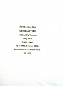
Newsletter, Heidelberg Golf Club Bowling Club, Heidelberg Golf Club Bowling Club: The Resting Toucher, and, Rinks Links, 2014-2016
... to walk the hills of the golf course to have a sporting... to walk the hills of the golf course to have a sporting ...Heidelberg Golf Club Bowling Club: Newsletters 2014-2016. The Bowling Club was formed in 1958 to enable members no longer able to walk the hills of the golf course to have a sporting involvement with the club. This folder contains various copies of the Bowling Club's newsletters, The Resting Toucher, and, Rinks Links. This set is incomplete.Multi page newsletters, text and illus. Incomplete set.heidelberg golf club bowling club, hgc newsletters, resting toucher, rinks links -
 Melbourne Tram Museum
Photograph - Set of 7 postcard size photographs - Wattle Park MMTB, Melbourne & Metropolitan Tramways Board (MMTB), 1960s
... of the buildings. 7 - part of the golf course.... of the golf course. Yields information about Wattle Park during ...Set of 7 photographs, probably by the MMTB of Wattle Park. 1 - Wattle Park Chalet building 2 - ditto - side view 3 - Children's playground area 4 - General view of the footpaths and park 5 - one of the water features 6 - View of some of the buildings. 7 - part of the golf course.Yields information about Wattle Park during the 1960s, which was owned and maintained by the MMTB.Set of 7 black and white photographs.tramways, mmtb, wattle park, golf -
 Heidelberg Golf Club
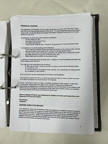
Administrative record - Financial records, Heidelberg Golf Club Bowling Club et al, Heidelberg Golf Club Bowling Club: Treasurer's folder, 2014-2017, 2014-2017
... no longer able to walk the hills of the golf course to have... no longer able to walk the hills of the golf course to have ...Heidelberg Golf Club Bowling Club: Treasurer's folder, 2014-2017. The Bowling Club was formed in 1958 to enable members no longer able to walk the hills of the golf course to have a sporting involvement with the club. This folder contains typed reports, bank statements and term deposit information compiled by the treasurer Pat Buckley.Black arch file binder containing typed and handwritten documents.heidelberg golf club bowling club, pat buckley, financial records -
 Phillip Island and District Historical Society Inc.
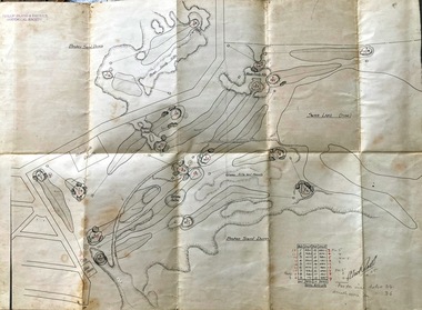
Map, Map of Summerland Golf Course, 15/12/1927
... Map of Summerland Golf Course...Summerland Golf Course.... Sampbell. It consisted of a housing estate, guest house and golf... Summerland Golf Course Broken sand dunes, rough sandy hills, grassy ...Summerland Estate was created in the 1920s by A.K. T. Sampbell. It consisted of a housing estate, guest house and golf course. This area was acquired and all buildings, roads etc removed by the Victorian Government in the 1980s for a nature reserve for the penguins. This is believed to be the only time in the world when humans have been removed to benefit nature. HistoricalPurple leather covered fold out linen map with hand drawn diagram of the topography, layout of golf holes and club house Broken sand dunes, rough sandy hills, grassy hills and mounds, Swan Lake, Par for nine holes 34, Scratch score for nine holes 36, Drawn by A. Russell 12/12/1927summerland estate, a.k. t. sampbell, map, penguin reserve, summerland golf course -
 Heidelberg Golf Club
Administrative record - Minute Book, Heidelberg Golf Club Bowling Club, Heidelberg Golf Club Bowling Club: Annual General Meeting Minutes 1973-1985, 1973-1985
... to walk the hills of the golf course to have a sporting... to walk the hills of the golf course to have a sporting ...Minutes of the Annual General Meetings of the Heidelberg Golf Club Bowling Club: 27/04/1973 - 27/03/1985. The Bowling Club was formed in 1958 to enable members no longer able to walk the hills of the golf course to have a sporting involvement with the club. This folder contains a incomplete set of AGM minutes for 1973-1985.Black folder containing typed minutes. Flagged 15th to 27th AGM.heidelberg golf club bowling club, committee minutes, annual general meetings -
 Heidelberg Golf Club
Administrative record - Minute Book, Heidelberg Golf Club Bowling Club, Heidelberg Golf Club Bowling Club: Annual General Meeting Minutes 2004-2009, 2004-2009
... to walk the hills of the golf course to have a sporting... to walk the hills of the golf course to have a sporting ...Minutes of the Annual General Meetings of the Heidelberg Golf Club Bowling Club: 16/11/2004 - 14/08/2009. The Bowling Club was formed in 1958 to enable members no longer able to walk the hills of the golf course to have a sporting involvement with the club. This folder contains a complete set of AGM minutes for 2004-2009.Black arch file binder containing typed minutes. heidelberg golf club bowling club, committee minutes, annual general meetings -
![Administrative record - Membership form, Thomastown Golf Club et al, Thomastown Golf Club. [Affiliated Clubs' membership forms], 1996](/media/collectors/4f729f5697f83e03086015b8/items/65ac7775fc29fd7dc16a6f67/item-media/65ac77e7fc29fd7dc16a7249/item-fit-380x285.jpg) Greensborough Historical Society
Greensborough Historical SocietyAdministrative record - Membership form, Thomastown Golf Club et al, Thomastown Golf Club. [Affiliated Clubs' membership forms], 1996
... not have an associated golf course, mainly social clubs.... These are clubs that do not have an associated golf course, mainly social ...Forms distributed by Thomastown Golf Club to Affiliated Clubs for interclub competition. These are clubs that do not have an associated golf course, mainly social clubs. These include clubs from Montmorency RSL, Dunlop Olympic Golf Club Wallan, Eltham RSL Social Club, etc. These slips were found in Secretary Robert Jones' 1996 diaryThomastown Golf Club was a social club formed in 1976. This is part of the Robert (Bob) Jones collection of Club memorabilia.Thomastown Golf Club. [Affiliated Clubs' membership forms]Handwritten and typed forms.thomastown golf club, bob jones, social golf -
 Heidelberg Golf Club
Administrative record - Financial records, Heidelberg Golf Club Bowling Club, Heidelberg Golf Club Bowling Club: Treasurer's folder, 2011/2012, 2013/2014, 2011-2014
... members no longer able to walk the hills of the golf course... members no longer able to walk the hills of the golf course ...Heidelberg Golf Club Bowling Club: Treasurer's folder, 2011/2012, 2013/2014. The Bowling Club was formed in 1958 to enable members no longer able to walk the hills of the golf course to have a sporting involvement with the club. This folder contains typed reports, bank statements and term deposit information compiled by the treasurer Pat Buckley.Black arch file binder containing typed and handwritten documents.heidelberg golf club bowling club, financial records, pat buckley -
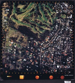
 Heidelberg Golf Club
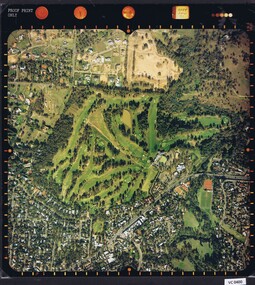
Photograph - Aerial Photograph, Heidelberg Golf Course 2000, 01/05/1980
... Heidelberg Golf Course 2000...Aerial photograph of Heidelberg Golf Club course in 1980... photograph of Heidelberg Golf Club course in 1980, showing the course ...Aerial photograph of Heidelberg Golf Club course in 1980, showing the course layout and surrounding land use.Aerial photograph, colour.Printed on edge of photo: "Colour proof", "LandSur756"aerial photographs, heidelberg golf club, lower plenty -
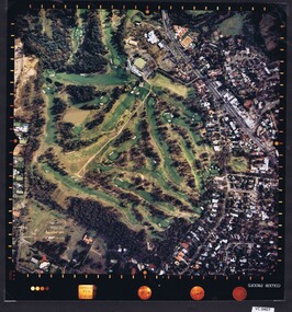
 Heidelberg Golf Club
Photograph - Aerial Photograph, Heidelberg Golf Course 2000, 01/05/1980
... Heidelberg Golf Course 2000...Aerial photograph of Heidelberg Golf Club course in 1980... photograph of Heidelberg Golf Club course in 1980, showing layout ...Aerial photograph of Heidelberg Golf Club course in 1980, showing layout of course and surrounding land use.Aerial photograph, colour.Printed on edge of photo: "Colour proof", "LandSur756"aerial photographs, heidelberg golf club, lower plenty -
 Heidelberg Golf Club
Photograph - Aerial Photograph, Heidelberg Golf Course 2000, 01/05/1980
... Heidelberg Golf Course 2000...Aerial photograph of Heidelberg Golf Club course in 1980... photograph of Heidelberg Golf Club course in 1980, showing layout ...Aerial photograph of Heidelberg Golf Club course in 1980, showing layout of course and surrounding land use.Aerial photograph, colour.Printed on edge of photo: "Colour proof", "LandSur756"aerial photographs, heidelberg golf club, lower plenty