Showing 256 items
matching gutter
-
 Eltham District Historical Society Inc
Photograph, Water Main Pipe Track (Madine Way-Eucalyptus Road), Eltham, 3 Sep 1981
Roll of film taken by Eltham Shire Council officers of roads and houses in the Eltham East area, 3 September 1981 prior to construction of new water main; including views of existing damage to footpaths and gutters and general views of Beard Street. These images provide a perspective of housing estate developments and changes in housing styles and road development which began sweeping in from the mid 1970s with increasing urbanisation of what was once more outlying suburbs and regions.35mm colour positive transparency (1 of 28) Mount - Kodak Kodachrome Cardeltham, infrastructure, roads, water main pipe track, madine way, eucalyptus road, tadema park -
 Glen Eira Historical Society
Photograph, Beauville Avenue, 35, Murrumbeena, 2001
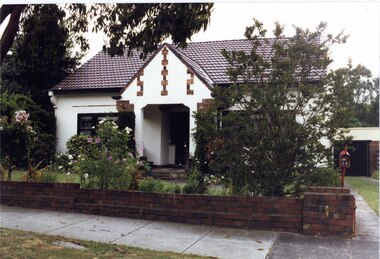
Originally labelled "Beauville Estate, Established 1936, Still Thriving 65 years on, 10th March 2001", the Beauville Estate Album contains colour photographs of houses in the Estate. They were taken around the time of the Beauville Estate’s 65th Heritage Celebration held on 10/03/2001 and donated to the Caulfield Historical Society shortly afterwards. Photographer unknown. Windows frames, gutters and drain pipe all painted black but this is same property as 2104A-39 where they are painted green.City of Glen Eira’s Heritage Management Plan Vol 2 p79 (this is p84 of the pdf version) – HO12 Beauville Estate and environs, Murrumbeena: The Beauville Historic Area is important at the State level as the first large housing estate undertaken by the AV Jennings Construction Co, later Jennings Group Limited, Victoria’s largest home builder. It is important also as a very early estate development incorporating a range of features other than houses and including made roads, shops and recreation facilities. In this respect it was the forerunner of the comprehensively planned housing estate of the post war era. The estate is distinguished by its aesthetic values, as is the earlier and comparable Hillcrest Estate, which are formed by a combination of restrained diversity in house styles, with the exception of no. 30 in the emerging International style, and by a landscaped garden environment. See Significance Statement in Glen Eira’s Heritage Management Plan by Andrew Ward (1996) Vol 2 p.79. Available from https://www.gleneira.vic.gov.au/media/4779/heritage_management_plan_volume_2.pdf (Note see p.84 of pdf)Colour photograph of white rendered house with unpainted variegated brown brick features including a geometric pattern of 3 vertical shapes on the gable over the porch. Other features include a wide arched porch, tiled roof and low unpainted brown brick fence in the foreground with "35" on the reddish brown metal letterbox on top of the brick pillar beside the driveway. Garage has a matching brown brick feature wall.murrumbeena, houses, beauville avenue, architectural styles, 1930's, inter war style, a.v. jennings, av jennings, jennings, brick houses, beauville estate, porches, letterboxes, sir albert victor jennings, a v jennings construction co, beauville estate heritage area, glen eira city council, architectural features, jennings group limited, land subdivision, gardens, beauville historic area, rendered houses, brick features, arches, brick fences, garages (private), gables -
 Glen Eira Historical Society
Photograph, Beauville Avenue, 35, Murrumbeena, 2001
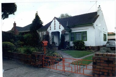
Originally labelled "Beauville Estate, Established 1936, Still Thriving 65 years on, 10th March 2001", the Beauville Estate Album contains colour photographs of houses in the Estate. They were taken around the time of the Beauville Estate’s 65th Heritage Celebration held on 10/03/2001 and donated to the Caulfield Historical Society shortly afterwards. Photographer unknown. Windows frames, gutters and drain pipe all painted green but this is same property as 2104A-38 where they are painted black.City of Glen Eira’s Heritage Management Plan Vol 2 p79 (this is p84 of the pdf version) – HO12 Beauville Estate and environs, Murrumbeena: The Beauville Historic Area is important at the State level as the first large housing estate undertaken by the AV Jennings Construction Co, later Jennings Group Limited, Victoria’s largest home builder. It is important also as a very early estate development incorporating a range of features other than houses and including made roads, shops and recreation facilities. In this respect it was the forerunner of the comprehensively planned housing estate of the post war era. The estate is distinguished by its aesthetic values, as is the earlier and comparable Hillcrest Estate, which are formed by a combination of restrained diversity in house styles, with the exception of no. 30 in the emerging International style, and by a landscaped garden environment. Colour photograph of white rendered house with unpainted variegated brown brick features including a geometric pattern of 3 vertical shapes on the gable over the porch. Other features include a wide arched porch, tiled roof and low unpainted reddish brown brick fence in the foreground with "35" on the reddish brown metal letterbox on top of the brick pillar beside the driveway. There are low, red, wrought iron gates across the driveway entrance. Garage has a matching brown brick feature wall.murrumbeena, houses, beauville avenue, architectural styles, 1930's, inter war style, a.v. jennings, av jennings, jennings, brick houses, beauville estate, porches, letterboxes, sir albert victor jennings, a v jennings construction co, beauville estate heritage area, glen eira city council, architectural features, jennings group limited, land subdivision, gardens, beauville historic area, rendered houses, brick features, arches, brick fences, garages (private), gables -
 Bendigo Historical Society Inc.
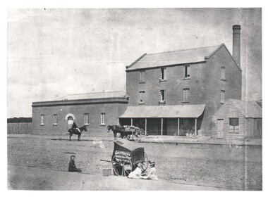
Photograph - WES HARRY COLLECTION: E. J. BUCKLEY FLOUR MILL, 1860's
Photograph of a brick Mill complex, the main building is three stories high with a concave verandah over the ground floor, underneath the verandah to the right of the main doorway are some bags of grain. To the left of the main building there is a single story structure with E & J Buckley written on an arch over the main doorway. There is a man on horseback on the street and horse and cart backed up to the main building. In the foreground is Batchelders photographic cart and there are three girls sitting near it in the gutterBatchelderbuildings, commercial, flour mill, batchelder, buckley , flour mills -
 Ballarat Tramway Museum
Slide - 35mm slide/s - set of 2, Mark Plummer, Sep. 1971
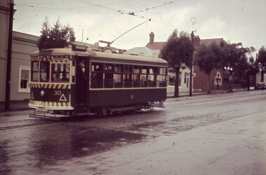
Photo of Ballarat tram No. 30 east bound or inbound in Sturt St., about to cross Doveton St. Tram has destination of Lydiard St. North. 2159.1 - shows gutter and pole arrangement in Sturt St. Has the spire of St Andrews Kirk (church) in the background. 2159.2 - photo taken just before tram crosses Doveton St. Note directional signs on the pole. Kodak cardboard mount slide, taken Mark Plummer, September 1971tramways, trams, sturt st, doveton st, tram 30 -
 Ballarat Tramway Museum
Slide - 35mm slide/s, Travis Jeffrey, c1961
Agfa plastic mount (blue base, white cover) with a photo of Bendigo No. 30 in Mitchell St, just before start of the double track section, c1962. Photo taken during a rainy day. Tram has destination of Eaglehawk. Note SEC crewman standing by door and the passengers looking towards the gutter at the railway station stop. Apparently picking up passengers ex the train on a Sunday. See Other Information regarding a possible date of the slide."BES 1" in penciltramways, trams, bendigo, mitchell st, tram 30 -
 Melbourne Tram Museum
Photograph - Black & White Photograph/s, Tramway Museum Society of Victoria (TMSV), c1975
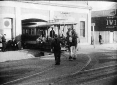
Black & White Photograph by the TMSV Sales of a cable car set being hauled out of the North Fitzroy depot, Nicholson St, c1938 by a horse. Normally a tractor was used for this purpose. Note the large drainage pit on the gutter and that the grip mechanism has been lifted out plus the Bundy clock on the depot wall. Photo print was printed backwards - image i2 has been corrected. Image has been reproduced from a movie - Commuting by Cable?Has the TMSV Sales stamp on rear and "1938" on the rear in pencil.trams, tramways, cable trams, grip tram, nicholson st, north fitzroy, bundy clock -
 Villa Alba Museum
Photograph - Waste water pipes, c.1987
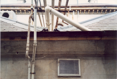
Built for William and Anna-Maria Greenlaw in the early 1880s, and with interiors decorated by the Paterson Bros, Villa Alba remained in private ownership until 1949. From 1950, the house was owned by a number of institutions. By 1984, the Villa Alba Preservation Society had been formed, and three years later, the Mount Royal Hospital granted a 25-year lease to Kew Council. In 2004, the title to Villa Alba was passed by the Victorian Government to The Villa Alba Museum Incorporated. The Museum, at 44 Walmer Street, Kew, is now a cultural institution committed to the collection, study and display of 19th century interior decorative finishes, and the components of 19th and 20th century interior decoration.This is one of a number of historically and aesthetically significant photos of the interiors and exterior of Villa Alba when it was still owned by the Mount Royal Hospital, showing twentieth century accretions and deterioration of the historic fabric of the building. This was a benchmark survey against which future conservation and restoration activities can be measured.In December 1987, Mockridge Stahle & Mitchell Pty Ltd Architects prepared ‘Villa Alba Survey: A Report on the fabric for Mount Royal Hospital’ of which this photograph is a part. Photo of numerous pipes, all installed during the period when the house was owned by the Royal Women's Hospital as a home for nurses (1950-1974). The pipes extended from a bathroom installed at the end of the first floor hall, running along the box gutter to the rear of the building. [The pipes were removed in subsequent restorations].villa alba museum, conservation photographs, victorian architecture, drain pipes, waste water -
 Southern Sherbrooke Historical Society Inc.
Photograph - Morning tea during hay carting at the Hermon farm
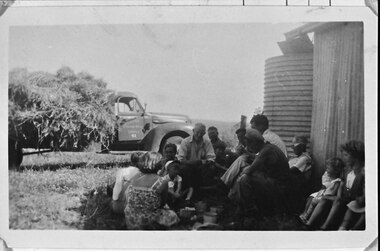
B&W photo of a group of adults and children having morning tea during hay carting on the Hermon farm. There are five men, one woman wearing a floral summer dress, and five children.They are sitting beside a corrugated iron shed with a large water tank behind it. A piece of guttering from the shed feeds into a broad piece of sheeting and then into the tank. Beyond the group is a truck laden with hay. The driver's door is ajar. Hills are visible in the background. Dated c.1950s. -
 Ballarat Tramway Museum
Photograph - Black & White Photograph/s, Chris Wurr, late 1960's or early 1970's
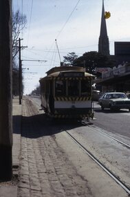
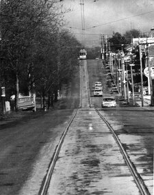
Yields information about the tramway and the street scene in Lydiard St Nth during the last few years of tramway operation.Black and White photograph of SEC tram 34 travelling along Lydiard St. North, bound for the Lydiard St. North terminus. Photo shows the tree lined route and how the road surfaces was not fully sealed to the gutter, but with a crushed rock edge. Photo taken by Chris Wurr during late 1960's or early 1970's. Photocopy made 4/1999 for display purposes. Copy 2 - as above, ex Alan Bradley 5/2007 - added 27/7/2007.Copy 1 - On rear, in black stamp ink "Photo by Chris Wurr / 12 Truscott Street, Ararat 3377 / (053) 523403. Copy 2 - Additional words to above "Donated to BTPS by and"trams, tramways, lydiard st. nth, tram 34 -
 Kew Historical Society Inc
Photograph - The Boulevard at Kew, 1937
The Yarra Scenic Boulevard stretching from Hawthorn to the Chandler Highway was completed as a major project between 1933 and 1936 during a period of significant unemployment. Key dates in the construction this section the road include: 1933 when Kew Council supported the construction of the road from Studley Park to the Kew Asylum; and 1936 when the road from the Johnston Street Bridge to the Chandler Highway was opened. The inscription on the reverse of the photo 'Boulevard Fairfield' is misleading as there is no section of the Boulevard in Fairfield. A more likely interpretation is that it is a photograph of the Kew section of the Yarra Boulevard with the factories of Fairfield in the distance.Rare early photograph of the Yarra Boulevard, taken one year after the opening of the road. The photograph is an important historical record of the results of 'Susso' labor in the creation of major works in Melbourne by the Victorian Government. Original, black and white positive print of the Boulevard at Kew in 1937. Key aspects to note about the photograph is that the road is bituminised; that the gutters are concreted; that the kerb is constructed of concrete blocks; and that there is an unmade footpath on what appears to be the right hand side of the road. The landscape is sparsely treed, and those trees that remain are presumably remnant vegetation. At the right, the land is fenced. The land at the left falls away sharply to the river below. On the horizon, at left, there is an industrial complex including a tall chimney that is burning fuel creating smoke. "Boulevard Fairfield" great depression, susso projects, roads -- kew (vic.), yarra boulevard, yarra valley -
 Melbourne Tram Museum
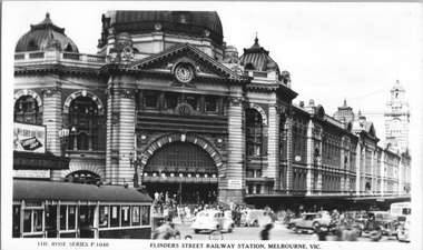
Postcard, Rose Stereograph Co, "Flinders Street Railway Station, Melbourne", early 1940s
Rose Series postcard No. P 1040, titled "Flinders Street Railway Station, Melbourne" showing the entrance to the station, many motor cars, some with black-out headlight covers, a MMTB Leyland bus, and a W2 class tram either 288 or 388 (Kew Depot cars at the time.) with the destination of Spencer St. This would have to be one of the first W2 class cars to have the metal gutter replaced by a storm/drip rail. There is an advertising board on the railway station verandah, advertising Liberty Loans. You can just make out the tram overhead for the curve from Swanston Street into Flinders Street.Yields information about Flinders Street and railway station in the early 1940s.Postcard - printed real photograph with Rose Stereograph Co. name on the rear.tramways, trams, flinders st, flinders st station, w2 class, buses, mmtb buses, world war ii -
 Bendigo Historical Society Inc.
Photograph - HANRO COLLECTION: PHOTO OF HANRO KNITTING MILLS
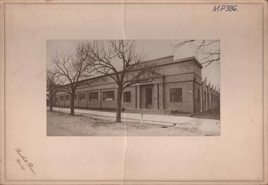
Photo of Hanro Knitting Mills: On Cream card with 6cm border is a photo of the Hanro Knitting Mills building in Hargreaves Street Bendigo. Of brick construction with doors either end. Four steps lead up to the doors and 10 windows along the front facing Hargreaves Street. A path with open gutters of blue stone block runs along the front of the building. Out from the path are three established trees on the nature strip. The view in the photo also shows part of the right hand side of the building. On the top written in black ink is *MP386*. Box 116ABartlett Bros., Bendigohanro, clothing, hanro knitting mill building, hanro knitting mill building. hargreaves street. -
 Ballarat Tramway Museum
Photograph - Black & White Photograph/s, Peter Bruce, c1970
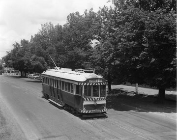
Black and white photograph of Barkly St. Mt Pleasant taken with a long telephoto lens. Single truck Tram on the top of a hill at terminus, with the photographer on or near the top of the`next hill in centre of track. Four cars travelling towards photographer. Sign of Caltex Service station on right side of photograph. with trees on left. Shows nature of street construction - deep gutters with "bridge" crossings. See also item No. 559, possibly tram No. 31. Would appear to be taken at about the same time, not parked Holden station wagon on left hand side of photo.trams, tramways, ballarat, barkly st, mt pleasant -
 Kew Historical Society Inc
Photograph - Denmark Street, Kew, 1972
The Engineer's Department of the former City of Kew had an extensive collection of photograph of sites in Kew requiring documentation to inform public works. It also kept images of engineering practice in other parts of Melbourne, and overseas, that could be used as models for local activity. Many of these photographs (and plans) were donated to our collection in the 1980s. A number of the photographs are annotated, either on the image itself or on the reverse.This photograph, and others sourced from the City Engineer's Department of the former City of Kew, qualifies as an important record of local streets, public works, street beautification, and engineering techniques of the period. Original black and white photographic positive of automobiles and buildings in Denmark Street, Kew, immediately before the road enters Kew Junction. On the left is McKeon Motors and a retailer of Insulwool, while in the distance is the pharmacy on the corner of High Street and Princess Street (later demolished during the widening of Kew Junction). Notable are the bluestone guttering and what appears to be vacant land on the apex of the triangle of land bounded by High Street South, Denmark Street and Barkers Road. This site was the original location of O'Shaughnessy's 'Kew Hotel', and after the destruction by fire of the latter, the location of a service station. [It is now the site of the Cresco Reserve].Annotation verso: "Indicating the existence of a vehicular entrance at Denmark St abuttal of No.188 High St prior to reconstruction of channeling &c 1972."denmark street -- kew (vic.), kew junction, luestone gutters, mckeon motors, insulwool -
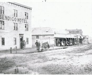 Bendigo Historical Society Inc.
Photograph - BRIDGE STREET: SANDHURST, 1861
Copy of black and white photo: Bridge Street streetscape near site of the present Chinese Museum. Showing Bendigo Hotel at left,. 'Crossingham & Goodman, Saddlers ' ' J. Holdsworth', 'Glass and Chines Warehouse'. 'Batchelder, Photographer, Pall Mall' handcart in foreground. 3 storey weatherboard building with 3 males at door, 2 males and photographers cart in front of fence. Row of single storey buildings with verandahs, some with business signs. 2 storey building at back. Deep gutters with foot bridges over. On back in grey lead '12' Note: Batchelder and his assistant are standing at the hardcart' ( James Lerk 22.9.2000 }Batchelder, Pall Mallplace, streetscape, bridge street -
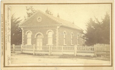 Bacchus Marsh & District Historical Society
Photograph, Baptist Chapel Lerderderg Street Bacchus Marsh 1883
The Baptist Chapel was first opened in March 1868 in Lerderderg Street, Bacchus Marsh, next to State School No. 28. The plans were prepared by James G. Pippett and the building was constructed by bricklayer J.F.Taylor and carpenter W. Nelson. When fire threatened its destruction in 1871, the townspeople assisted in saving the building by tearing off the roof and removing windows and flooring. Subsequently it was found that a solid silver Communion Service was missing as well as the contents of the Poor Box. The Chapel was renovated and used until 1898 when the building was moved to Main Street, next to the Post Office. Two rooms were added at the front when the building was rebuilt. It was demolished in 1985.Small sepia unframed photograph on card with gold border framing photograph. Housed in the Jeremeas Family Album, which contains photographs of Bacchus Marsh and District in 1883 by Stevenson and McNicoll. The photograph is of a substantial brick building with a shingle roof. The gable above the front entrance and the side of the building under the guttering are ornamented with rows of bricks laid horizontally. A round window sits in the centre of the gable. The central door and the front and side sash windows are topped by semi-circular brick arches. The ornamentation is continued with contrasting bricks down the corners of the building. An ornamental iron fence runs along the front of the building. A large fir tree stands in the grounds. On the front: Stevenson & McNicoll. Photo. 108 Elizabeth St. Melbourne. COPIES CAN BE OBTAINED AT ANY TIME. On the back: LIGHT & TRUTH inscribed on a banner surmounted by a representation of the rising sun. Copies of this Portrait can be had at any time by sending the Name and Post Office Money Order or Stamps for the amount of order to STEVENSON & McNICOLL LATE BENSON & STEVENSON, Photographers. 108 Elizabeth Street, MELBOURNE churches bacchus marsh, baptist chapel bacchus marsh -
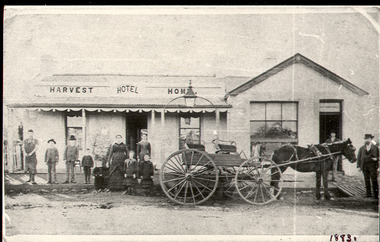 Bacchus Marsh & District Historical Society
Photograph, Harvest Home Hotel Main Street Bacchus Marsh c.1880s-1890s
The Harvest Home Hotel was licensed as a beer shop in 1866. Patrick Vallence was the licensee. On his death in 1874 his widow Mrs M. A. Vallence obtained the license. The date that this image was created has not been identified. Around 1883 George Marshall was leasing the hotel. The people in this image are could be members of the Marshall family and some of the staff who worked in the hotel at this time. Following a decrease in the population of Bacchus Marsh by 1911 the hotel had lost its licence. The Vallence family still owned the building after the loss of the hotel license in 1911and it was used for some years after this as a private residence by some members of the Vallence family. Small black and white photograph. The image depicts the Harvest Home Hotel situated in Main Street Bacchus Marsh. The name of the hotel can be seen above the verandah roof. The building appears to be of stone with decorative stonework corners. A verandah is inset to the left of a gabled front section which has its own door and window. A deep gutter runs along the front of the hotel, with a slab acting as a bridge to the road. Standing in front of the building facing the camera is a group of adults and children, men and women and boys and girls. A four seated buggy drawn by a single horse is also present in the image. The lantern erected above the horse trough can be seen.hotels bacchus marsh, vallence family bacchus marsh, marshall family bacchus marsh, harvest home hotel bacchus marsh -
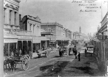 Ballarat Tramway Museum
Photograph - Black & White Photograph/s, 1880's
Yields information about the streetscape of Bridge St about 1880, prior to trams, with horse drawn carts and gravel streets and businesses.Black and White copy photograph of a Gold Museum photograph - Bridge St, about 1880. Looks from intersection with Main St to the west. Shows many horse drawn carts, people, gravel paved streets with bluestone gutters. Buildings in the image - Pittards Warehouse, M.J. Robinson and Shilling Arcade. On the right hand side are three lamps, one with a sign "Good Beds 1s". Original photograph (not in book) has a handwritten note "Bridge St about 1880 presented by Miss Anderson." Has pins hole showing in the original print. Collected by Alan Bradley from the Gold Museum early 1980's. Used in The Golden City and its Tramways - page 8.tramways, trams, bridge st, horse drawn vehicle, main st -
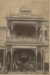 Bendigo Historical Society Inc.
Photograph - ABBOTT & CO BOOT AND SHOE MANUFACTURERS, c.1900
Sepia toned photograph of two story building. Cast iron supports to verandah and balcony. Ornate cast iron trim. New Times sign on parapet. Various sale signs on windows and front doors. Hitching post? In front of shop. Bags of grain, two males, 1 femal figures, four adolescents in front of building. Brick gutter. Wooden case on right. 'Abbott's & Co. Pall Mall Bendigo Boot and Shoe Store' . Check directories for dates of occupation. James Lerk 17/12/1999. History of object: The very flamboyant front for Abbott & Co Boot and Shoe Manufacturers. Abbotts conducted a tannery at Sheepwash - a wonderful example of an industry 'adding'. Photos. C1900. James Lerk caption.buildings, commercial, abbotts boot & shoe manufacturers -
 Ringwood and District Historical Society
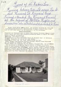
Memorabilia, Record of Historic Lane and formation of Carmel Haven Kindergarten, Ringwood East, Victoria - 1956
Buying of Carmel Haven and formation of kindergarten after Mrs. Olive Raftis and a committee bought the historic lane which ran between Victoria St. Lois St. and Wenwood St. Ringwood East.Six pages of memorabilia about the historic lane running between Victoria Street across Lois Street and Wenwood Street, Ringwood East formed by Ringwood Council at the request of Mrs. Olive Raftis and Committee who collected and subscribed to the lane, including picture of house bought to use as a Kindergarten. 26269-1. Description of location and photograph with summary of Kindergarten activities 26269-2. Newsletter - Second meeting of ratepayers to discus lane 26269-3. Receipt from Borough of Ringwood for supply of 400 square yards of concrete path Victoria Street to Wenwood Street to Mrs. Raftis 26269-4. Receipt to Committee for 18 yards of gravel for concrete gutter. 26269-5. Receipt to Mrs. O. Raftis £5 with 2d Victoria Stamp Duty attached. 26269-6. List of contributers. -
 Melbourne Tram Museum
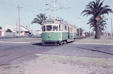
Slide, Keith Caldwell, 12/03/1960 12:00:00 AM
Agfa Colour slide, cardboard mount, by Keith Caldwell dated 12 March 1960, of W5 818 running in Mount Alexander Road, North Essendon, crossing the street access for Marco Polo Street. The tram showing route 59, Essendon Aerodrome, has trolley wheels and has a second person in the cab, possibly a trainer. Unusually the tram number is placed above the headlight, In the background are the palm trees in the centre median plantation. The house with the red guttering is one that dates back to the gold mining era. See http://www.esshissoc.org.au/1070%20Mount%20Alexander%20Road.pdf It was relocated to Woodland Park during 2017? Note the Centre poles, overhead construction and street light. Also in the background is a Mobil Service station that later became a garden centre. Now a block of apartments.hand stamped "12 Mar '60"trams, tramways, mount alexander rd, north essendon, essendon airport, essendon aerodrome, route 59, w5 class, tram 818 -
 Bacchus Marsh & District Historical Society
Photograph, Royal Hotel corner of Main and Young Streets Bacchus Marsh 1883
This image is one of a series of photographs taken by Melbourne based photographers Stevenson and McNicoll who visited Bacchus Marsh nearby districts between September and November 1883. The Royal Hotel was built in 1861 and is located on the corner of Main and Young Streets in Bacchus Marsh. The first owner was James Murray and the hotel was first known as the Murray Family Hotel. James Murray died in an accident in 1863 and sometime after this the ownership passed to Richard Manning. From around 1869 it became known as the Royal Hotel. Richard Manning's son Frederick Manning inherited the hotel in 1896. The Manning family owned the hotel until sometime after 1945. In more recent decades it has been owned and operated by a number of different people. The hotel continues to operate as of 2024. This image shows the building in its original structure. In 1888, five years after this image was taken, a second storey was added to the section on Young Street. In this image this section is the single storey section of wall without windows to the right of the picture. Small sepia 'carte de viste' style unframed photograph on card with gold border framing photograph. Housed in the album, 'Photographs of Bacchus Marsh and District in 1883 by Stevenson and McNicoll'. The image shows the Royal Hotel seen from the intersection of Main and Young Streets. The diagonal view shows both the Main Street and Young Street sides of the building. It is a two storey brick building with a single storey brick extension on the Young Street frontage. Standing at the corner of the building is a woman and five girls. A deep gutter runs along the Main Street, with a pedestrian crossing ramp. Over this crossing point, there is a large metal frame bearing an ornate lantern. Next to it is a water trough for horses. Several hitching posts can be seen along the footpaths.Printed On the front: Stevenson & McNicoll. Photo. 108 Elizabeth St. Melbourne. COPIES CAN BE OBTAINED AT ANY TIME. On the back: LIGHT & TRUTH inscribed on a banner surmounted by a representation of the rising sun. Copies of this Portrait can be had at any time by sending the Name and Post Office Money Order or Stamps for the amount of order to STEVENSON & McNICOLL LATE BENSON & STEVENSON, Photographers. 108 Elizabeth Street, MELBOURNE. stevenson and mcnicoll 1883 photographs of bacchus marsh and district, hotels bacchus marsh, royal hotel bacchus marsh, manning family bacchus marsh, murray family hotel bacchus marsh -
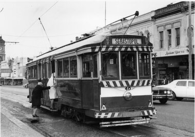 Ballarat Tramway Museum
Photograph - Black & White Photograph/s - set of 2, The Courier Ballarat, 18/09/1971 12:00:00 AM
Yields information about the nature of the day on the last full day of operation in Sturt St and how passengers boarded the tram from the median strip.Black and White copy photographs of a newspaper photograph taken by The Courier - photo taken 18/9/1971, one published 20/9/1971 of No. 40 picks up shoppers, Sturt & Dawson Sts corner, last Saturday of service. 3772.1 - Shows two ladies boarding the tram from a crossover over the gutter. 3772.2 - shows the tram just after it left the stop. Has the Ritzy Cafe in the background. Also has a "Cars Stop Here" and a "End of Section sign in the photograph, that looks back along Sturt St. Tram has the destination of Sebastopol. One photo used in the Courier Supplement following the closure of the tramways. Collected by Alan Bradley from the Ballarat Courier early 1980's. See Excel file "Record of Ballarat Courier Photos SEC era" (Archive Documents) for source of details.On rear of 4772.2 stamped "Copyright, The Ballarat Courier Proprietary Limited." and "100%" in black ink, and "92A Rpt" in felt pen.tramways, trams, sturt st, closure, dawson st, signs, tram 40 -
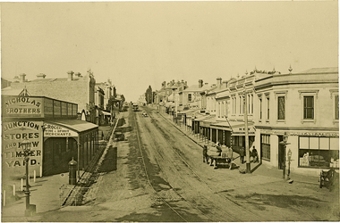 Kew Historical Society Inc
Photograph, J F C Farquhar, High Street, Kew, 1891
At the beginning of the 1890s, the Kew businessman and Town Councillor, Henry Kellett, commissioned J.F.C. Farquhar to photograph scenes of Kew. These scenes included panoramas as well as pastoral scenes. The resulting set of twelve photographs was assembled in an album, Kew Where We Live, from which customers could select images for purchase.The preamble to the album describes that the photographs used the ‘argentic bromide’ process, now more commonly known as the gelatine silver process. This form of dry plate photography allowed for the negatives to be kept for weeks before processing, hence its value in landscape photography. The resulting images were considered to be finely grained and everlasting. Evidence of the success of Henry Kellett’s venture can be seen today, in that some of the photographs are held in national collections.It is believed that the Kew Historical Society’s copy of the Kellett album is unique and that the photographs in the book were the first copies taken from the original plates. It is the first and most important series of images produced about Kew. The individual images have proved essential in identifying buildings and places of heritage value in the district.In 1891, High Street was the centre of commercial activity in the Borough of Kew. It was unpaved and edged with deep bluestone gutters, which were designed to channel the significant flow of storm water down the hill to and beyond the Junction. On either side of the entrance to the shopping strip are two cast iron gas lamps that provided the only public street lighting before the Post Office was reached. Most shops, including the Nicholas Brothers’ Junction Store featured cast iron verandas. Further up the hill, Dougherty’s Greyhound Hotel was by this stage a local institution. Apart from the horse-drawn tram, the main form of personal and commercial transport in this period remained the horse, horse and cart, or buggy.The panoramic view predates the widening of High Street in the 20th century, and thus includes the original alignment of buildings on the south side. These included Henry Kellett’s shop.High Street, Kewkew illustrated, kew where we live, photographic books, henry kellett, high street - kew (vic) -
 Federation University Historical Collection
Document - Documents, Golden Point - Mount Pleasant Progress Association Establishment
The Golden Point - Mt Pleasant Progress Association was established on Wednesday 6 April 1983. Membership was open to any person or organisation in the area generally bounded by Bridge mall and Skipton Street, Elsworth Street and main Road. annual family or organisation membership was $2.00. Mara Gluyas served as secretary of the Golden Point - Mt Pleasant Progress Association from 1983 to 1994. Ian McKinnon was the President from 1983 to 1992. Kerry Daniels was the President in 1994.A small white cardboard box with purple lid of A4 documents relating to the establishment of the Golden Point - Mt Pleasant Progress Association. The documents include the original constitution and minutes. Topics include: Pearce's Park; removal of elms, names and addresses of members, Sovereign Hill realignment; Sovereign Hill Lookout; membership form; Golden Point Historic Mines Direction Indicator; Ballarat Observatory; Nerrina Tip; Yarrowee Creek; Mine Capping (Sovereign Mine); tree planting (Sovereign Hill Lookout); Magpie Street Park; Hill Street; Yarrowee Flora Park; Barkly Street; South Street Bluestone Gutter; Ballarat Goldfields; Eastern baths site; Grant Street; Flooding; Aboriginal Advancement League; Sunnyside Woollen Mill; Chinese Garden; Golden Point Primary School closure; Ballarat West Goldfields; Sovereign Hill Land Title and Management Revision; Wainwright; Street; Llanberris; Yuille's Station Parkgolden point, mount pleasant, mt pleasant, ian mckinnno, mara gluyas, peter hiscock, frank williams, geoff howard, leigh gillett, sovereign hill, kerry daniels, norm strange; graeme kent; george netherway; keith rash; ian mckinnon, albert graham, bryan crebbin, jim humphreys. wid radbourn, heath martin, janet dore, alex mills park