Showing 217 items
matching house demolitions
-
 Bendigo Historical Society Inc.
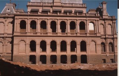
Photograph - LAW COURTS, PALL MALL, BENDIGO
Colour photo: rear of Law Courts building, Bendigo. Three storey storey building , each storey with arches. Demolition site of Police Headquarters in foreground, dirt piled up on LH side.organisation, government, law vcourts -
 Bendigo Historical Society Inc.
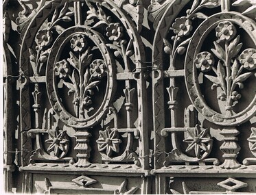
Photograph - DONEY COLLECTION; PHOTOGRAPHS OF CAST IRON LACEWORK
Collection of black and white photographs of cast iron lacework on Bendigo verandahs; which he had a deep appreciation. it was partially through his efforts that a number of verandahs were spared demolition. a detail of residence on cnr Rowan and Wattle Streets b detail Conservatorium Music in Rowan Street c frontage of Rifle Brigade Hotel, cnr Rowan & View Streets d detail Rifle Brigade Hotel, cnr Rowan & View Streets e detail Queens Hotel, 197 Mitchell Street f detail Martin Washington Photographic Studio, Williamson Street g detail Bendigo Spastic Centre h detail cnr Short & McKenzie Streets i detail Bridglands Music Shop j detail City Club Hotel k.detail Cnr View and McKemzie Streets l. detail Postal Engineer's Dept 17 McKenzie Street m. facade "Innisfail" Heathcote, home of Mr and Mrs T J Farley n.detail "Innisfail" Heathcote, home of Mr and Mrs T J FarleyAlan Doney -
 Bendigo Historical Society Inc.
Newspaper - JENNY FOLEY COLLECTION: WORKS PLANNED
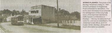
Bendigo Advertiser ''The way we were'' from Monday, July 11, 2005. Works planned: this photo in the Bendigo Advertiser of May 31, 1967 shows businesses on Eaglehawk Road scheduled for demolition. The works were necessary to accommodate the realignment of the Long Gully bend which had been declared a traffic hazard.newspaper, bendigo advertiser, the way we were -
 Bendigo Historical Society Inc.
Newspaper - AILEEN AND JOHN ELLISON COLLECTION: BENDOGO ADVERTISER SATURDAY, APRIL 13, 1968
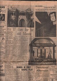
Four pages of the Bendigo Advertiser from Saturday, April 13, 1968. On back page 4 an article and three photos on the demolition of the manse of St Andrew's Presbyterian church in Myers street. On page 3 an article and two photos on the scouts annual Hoadlley Hide, this year the theme was 'gold fever'.newspaper, bendigo advertiser, various articles -
 Bendigo Historical Society Inc.
Document - HARRY BIGGS COLLECTION: OLD POLICE BARRACKS, 14/5/1970
Document. Harry Biggs Collection. A typewritten letter on Education Department Victoria letterhead dated 14/5/1970 from L. H. S. Thomson, Minister of Education to Mr. Trethewey telling him that because of the state of the Old Police Barracks he has no option but to ask the Public Works to arrange for the demolition of the Barracks.L. H. S. Thomsonorganization, club/society, community, harry biggs collection, old police barracks -
 Bendigo Historical Society Inc.
Magazine - HARRY BIGGS COLLECTION: TRUST NEWSLETTER, Dec. 1970
Magazine. Harry Biggs Collection. Trust Newsletter published. By National Trust of Australia Victoria Branch. December 1970 Vol 1 No 6 covers historical items of interest including 3 pages listing classified buildings in danger of demolition. On this list is the Old Police Barracks, Bendigo.National Trustmagazine, organization, bendigo trust newsletter, harry biggs collection, trust newsletter, old police barracks, bendigo -
 Bendigo Historical Society Inc.
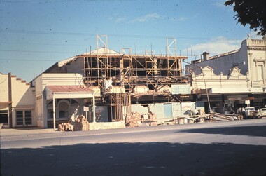
Slide - BENDIGO BUILDINGS, Nov 1961
Slide. Bendigo Buildings. The Bendigo Advertiser under demolition.slide, bendigo, bendigo buildings., bendigo buildings. -
 Bendigo Historical Society Inc.
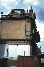
Slide - BENDIGO BUILDINGS & SCENERY, May 1971
Slide. Bendigo Buildings & Scenery. ANA Hall, View Street, Bendigo.The demolition of this building commences.slide, bendigo, bendigo buildings & scenery., bendigo buildings & scenery. -
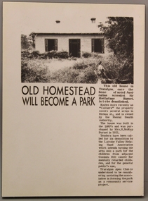 Grey Street Primary School, Traralgon
Photoboard
... Demolition of Burnet house in Traralgon.... to Traralgon. Demolition of Burnet house in Traralgon. Photoboard ...Newspaper report on the forthcoming demolition of the old Burnet house in Hickox St, Traralgon. The property is now a park adjacent to the Traralgon Special Developmental School and Cooinda Hill Centre.Burnet Family's continued connection to Traralgon.Demolition of Burnet house in Traralgon. -
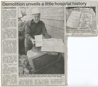 Ballarat Base Hospital Trained Nurses League
Ballarat Courier - Later Hospital Misc - eg. Building etc
... , demolition, wilson, building yuille, house, 2016, emergency ...Newspapertb, chalet, outpatients, bolte, wing, library, rowe, time, capsule, 1935, discovered, 2003, demolition, wilson, building, yuille, house, 2016, emergency, department, entrance, ballarat base hospital, north block, drummond, mair, public, open, day,1992 -
 Stawell Historical Society Inc
Photograph, Red Roof House
... line is unclear). Colour Photograph Showing a Red Roofed house ...Allen CrescentColour Photograph Showing a Red Roofed house taken from across the road on a angle prior to demolition. A metal sign on the fence reads "Mick teh Wrecker is here ( the second line is unclear) Pay cash (the last line is unclear). -
 Melbourne Athenaeum Archives
Season Brochure, MTC Melbourne Theatre Company Season 27 1980 performances at Athenaeum Theatre and Athenaeum 2
rosencrantz and guildenstern are dead, hamlet, as we are, bremen coffee, shakespeare the sadist, a boy for me, a girl for you, the maids, a doll's house, the matchmaker, privates on parade, the man who came to dinner, demolition job, mourning becomes electra -
Whitehorse Historical Society Inc.
Document, 'Tower House' Boarding School, 1932
... Mitcham melbourne Tower House Boarding School Surrey Hills Royal ...Photocopy of photographs by Norman B. Carter of 'Tower House' Boarding school, formerly 'Royal Hotel', 20 Aug 1932 showing demolition.tower house boarding school, surrey hills, royal hotel, surrey hills, schools, hotels, surrey hills -
Whitehorse Historical Society Inc.
Article, Vow to fight apartment building plan, 2007
... Mitcham Residents Association opposes demolition of Tudor... Association opposes demolition of Tudor-style house and cutting down ...Mitcham Residents Association opposes demolition of Tudor-style house and cutting down of many trees on the site of 520 Mitcham Road.Mitcham Residents Association opposes demolition of Tudor-style house and cutting down of many trees on the site of 520 Mitcham Road.Mitcham Residents Association opposes demolition of Tudor-style house and cutting down of many trees on the site of 520 Mitcham Road.mitcham residents association, hogg, tony, chamberlain, david, mitcham road mitcham, no. 520 -
Whitehorse Historical Society Inc.
Newspaper - Article, Mitcham halls make way for shopping development, 27/11/1985
Article from Nunawading Gazette re the demolition of the Mitcham Guide Hall and a weatherboard house to make way for Mitcham shopping centre development.commercial development, mitcham guide hall -
 Whitehorse Historical Society Inc.
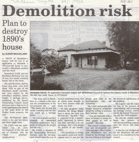
Article, Demolition risk, 28/01/1998 12:00:00 AM
Article in Whitehorse Gazette regarding a development application to replace a house in Blackburn Road built about 1890 as part of the Blackburn Model Township designed by architect Arthur Clarke. Bernadette Cahill who lives next door is interviewed as is Whitehorse City Council's acting Statutory and Development Manager, John Lupins. Photograph.blackburn road, blackburn, cahill, bernadette, blackburn model township, clarke, arthur, lupin, john, city of whitehorse, residential development -
 Whitehorse Historical Society Inc.
Photograph, Demolition of 27 Casella Street Mitcham, 2001
coloured photograph of house at 27 Cassella Street Mitcham being demolished to make way for units.casella street, no. 27 -
 Whitehorse Historical Society Inc.
Photograph, Demolition - 27 Cassella Street, Mitcham, 2001
Coloured photograph of of house at 27 Cassella Street, Mitcham being demolished to make way for units.cassella street, mitcham, no.27 -
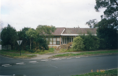 Whitehorse Historical Society Inc.
Photograph, Whitehorse Road, Mitcham No.734, 1/08/2002 12:00:00 AM
Coloured photograph of house to be demolished - 734 Whitehorse Road, Mitcham.demolition site, whitehorse road, mitcham no.734 -
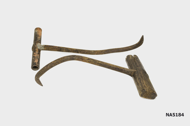 Whitehorse Historical Society Inc.
Functional object - Bag hooks, Bag hoocks (one metal & one wood handle), Unknown
Found under house at 6 Mt Pleasant Road Nunawading following demolition.Example of handmade tools used in wool industry.X 2 bag hooks used to handle bagged material(wool bales?)Nilbag hooks, wool industry -
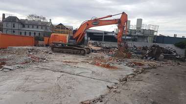 Ballarat Heritage Services
Photograph - Digital photographs, L.J. Gervasoni, Demolition after a fire - corner Grant and Armstrong Streets Ballarat, c2006
Digital images of demolition after a fire - corner Grant and Armstrong Streets Ballarat. The former Ballarat Supreme Court House is in the background. ballarat, grant street, armstrong street, demolition, brew tower, ballarat gaol -
 Ballarat Heritage Services
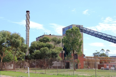
Digital photographs, L.J. Gervasoni, Boiler House CSR Timbrock Factory Maddingley Prior to Demolition, 2012, 2012
... to demolition. Boiler House CSR Timbrock Factory Maddingley Prior ...http://vhd.heritagecouncil.vic.gov.au/places/69285 Digital images of the csr Boiler House Timbrock Factory at Maddingley prior to demolition.jbd, timbrock, rowsley station, maddingley, factory, csr, jack mcconnell, heritage, boiler, house, industry, industrial -
 Ballarat Heritage Services
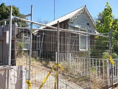
Photograph - Colour, Neglected House in Armstrong Street South, Ballarat, 2019, 19/01/2019
Colour photograph of a house in Armstrong Street South, Ballarat (400 block) which has been 'under repair for a number of years.ballarat, armstrong street south, demolition by neglect -
 Ballarat Heritage Services
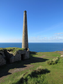
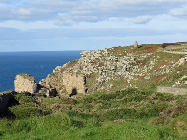
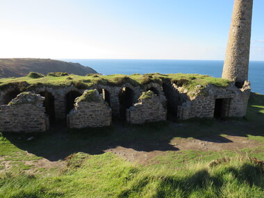
Photograph - Colour, Dorothy Wickham, St Just, Cronwall, World Heritage Site
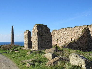
A stone’s throw from Land’s End, this is the most westerly Area of the Site. St Just is characterised by big skies, jagged rocks, stark moorland, and iconic clifftop engine houses perched above the Atlantic in some incredible locations. No wonder this dramatic setting has inspired generations of artists, writers and photographers. World-famous for their mineralogy, the mining sites here are extremely well preserved – as is the sense of community amongst the people whose lives they once dominated. This Area’s unique geography and mineralogy meant that undersea mining was more concentrated here than anywhere else in the world in the 18th and 19th centuries. The oldest surviving Cornish beam engine (constructed in 1840) remains in its original engine house at Levant, restored and still working under steam. Geevor, one of the last mines to close in Cornwall (1990), was saved from demolition and is now the largest metalliferous mine site open to the public in the UK. The historic mining town of St Just is home to characteristic rows of granite mine workers’ cottages, public squares, shops, cafés, art galleries and, just off Bank Square, a medieval grassed amphitheatre – the Plen an Gwary or ‘playing place’.st just, world heritage, ellis, penrose, cornwall, mining, mines -
 Ballarat Heritage Services
Photograph - Colour, Dorothy Wickham, St Just, Cornwall, World Heritage Site
A stone’s throw from Land’s End, this is the most westerly Area of the Site. St Just is characterised by big skies, jagged rocks, stark moorland, and iconic clifftop engine houses perched above the Atlantic in some incredible locations. No wonder this dramatic setting has inspired generations of artists, writers and photographers. World-famous for their mineralogy, the mining sites here are extremely well preserved – as is the sense of community amongst the people whose lives they once dominated. This Area’s unique geography and mineralogy meant that undersea mining was more concentrated here than anywhere else in the world in the 18th and 19th centuries. The oldest surviving Cornish beam engine (constructed in 1840) remains in its original engine house at Levant, restored and still working under steam. Geevor, one of the last mines to close in Cornwall (1990), was saved from demolition and is now the largest metalliferous mine site open to the public in the UK. The historic mining town of St Just is home to characteristic rows of granite mine workers’ cottages, public squares, shops, cafés, art galleries and, just off Bank Square, a medieval grassed amphitheatre – the Plen an Gwary or ‘playing place’.st just, world heritage,, ellis,, penrose, cornwall, mining, mines -
 Ballarat Heritage Services
Photograph - Colour, Dorothy Wickham, St Just, Cornwall, World Heritage Site
A stone’s throw from Land’s End, this is the most westerly Area of the Site. St Just is characterised by big skies, jagged rocks, stark moorland, and iconic clifftop engine houses perched above the Atlantic in some incredible locations. No wonder this dramatic setting has inspired generations of artists, writers and photographers. World-famous for their mineralogy, the mining sites here are extremely well preserved – as is the sense of community amongst the people whose lives they once dominated. This Area’s unique geography and mineralogy meant that undersea mining was more concentrated here than anywhere else in the world in the 18th and 19th centuries. The oldest surviving Cornish beam engine (constructed in 1840) remains in its original engine house at Levant, restored and still working under steam. Geevor, one of the last mines to close in Cornwall (1990), was saved from demolition and is now the largest metalliferous mine site open to the public in the UK. The historic mining town of St Just is home to characteristic rows of granite mine workers’ cottages, public squares, shops, cafés, art galleries and, just off Bank Square, a medieval grassed amphitheatre – the Plen an Gwary or ‘playing place’.st just, world heritage, ellis, penrose, cornwall, mining, mines -
 Ballarat Heritage Services
Photograph - Colour, Dorothy Wickham, St Just, Cronwall, World Heritage Site
A stone’s throw from Land’s End, this is the most westerly Area of the Site. St Just is characterised by big skies, jagged rocks, stark moorland, and iconic clifftop engine houses perched above the Atlantic in some incredible locations. No wonder this dramatic setting has inspired generations of artists, writers and photographers. World-famous for their mineralogy, the mining sites here are extremely well preserved – as is the sense of community amongst the people whose lives they once dominated. This Area’s unique geography and mineralogy meant that undersea mining was more concentrated here than anywhere else in the world in the 18th and 19th centuries. The oldest surviving Cornish beam engine (constructed in 1840) remains in its original engine house at Levant, restored and still working under steam. Geevor, one of the last mines to close in Cornwall (1990), was saved from demolition and is now the largest metalliferous mine site open to the public in the UK. The historic mining town of St Just is home to characteristic rows of granite mine workers’ cottages, public squares, shops, cafés, art galleries and, just off Bank Square, a medieval grassed amphitheatre – the Plen an Gwary or ‘playing place’.st just, world heritage, ellis, penrose, cornwall, mining, mines -
 Ballarat Heritage Services
Photograph - Colour, Dorothy Wickham, St Just, Cornwall, World Heritage Site
A stone’s throw from Land’s End, this is the most westerly Area of the Site. St Just is characterised by big skies, jagged rocks, stark moorland, and iconic clifftop engine houses perched above the Atlantic in some incredible locations. No wonder this dramatic setting has inspired generations of artists, writers and photographers. World-famous for their mineralogy, the mining sites here are extremely well preserved – as is the sense of community amongst the people whose lives they once dominated. This Area’s unique geography and mineralogy meant that undersea mining was more concentrated here than anywhere else in the world in the 18th and 19th centuries. The oldest surviving Cornish beam engine (constructed in 1840) remains in its original engine house at Levant, restored and still working under steam. Geevor, one of the last mines to close in Cornwall (1990), was saved from demolition and is now the largest metalliferous mine site open to the public in the UK. The historic mining town of St Just is home to characteristic rows of granite mine workers’ cottages, public squares, shops, cafés, art galleries and, just off Bank Square, a medieval grassed amphitheatre – the Plen an Gwary or ‘playing place’.st just, world heritage, ellis, penrose, cornwall, mining, mines -
 Ballarat Heritage Services
Photograph - Colour, Dorothy Wickham, St Just, Cornwall, World Heritage Site
A stone’s throw from Land’s End, this is the most westerly Area of the Site. St Just is characterised by big skies, jagged rocks, stark moorland, and iconic clifftop engine houses perched above the Atlantic in some incredible locations. No wonder this dramatic setting has inspired generations of artists, writers and photographers. World-famous for their mineralogy, the mining sites here are extremely well preserved – as is the sense of community amongst the people whose lives they once dominated. This Area’s unique geography and mineralogy meant that undersea mining was more concentrated here than anywhere else in the world in the 18th and 19th centuries. The oldest surviving Cornish beam engine (constructed in 1840) remains in its original engine house at Levant, restored and still working under steam. Geevor, one of the last mines to close in Cornwall (1990), was saved from demolition and is now the largest metalliferous mine site open to the public in the UK. The historic mining town of St Just is home to characteristic rows of granite mine workers’ cottages, public squares, shops, cafés, art galleries and, just off Bank Square, a medieval grassed amphitheatre – the Plen an Gwary or ‘playing place’.st just, world heritage, ellis, penrose, cornwall, mining, mines -
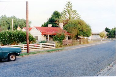
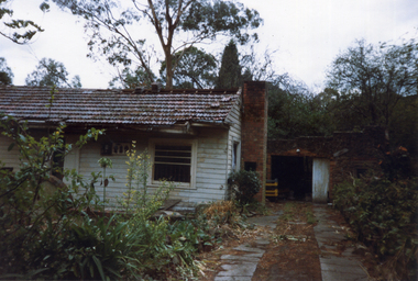
 Southern Sherbrooke Historical Society Inc.
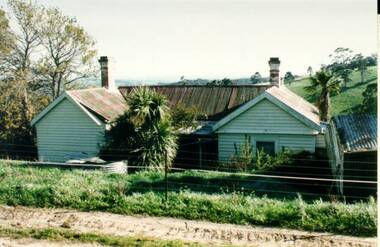
Photograph - Glen Park homestead, Menzies Creek
Colour photograph of Glen Park homestead at Menzies Creek prior to its demolition in the early 2000's. Photo shows house's north wall with two gables and a verandah between. Photo from Victorian heritage study.