Showing 218 items matching "library block"
-
 Ringwood and District Historical Society
Newspaper, Scrapbook Clipping, Library Collection, Ringwood, Victoria
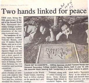
Newspaper Clipping from "The Post", 23-8-1995, P 15, "Two hands linked for peace"The year 1995, being the 50th anniversary of the end of the Second World War. Norwood Secondary Teachers College teachers aimed to increase student awareness of the war years in several ways. The handprints of visiting Japanese student, Tomomi Honda, and year 10 student Hayley Marks, were set in a concrete block in a unique tribute to peace. A Japanese maple tree was planted beside the plaque. -
 Port Melbourne Historical & Preservation Society
Booklet - Amenities Block, J Kitchen & Sons, Unilever Australia Pty Ltd, 1957
Nineteen page booklet with pale blue card cover (with drawing of Amenities Block) and brighter blue binding. The introduction states that the building is about to be completed and it is for all employees use. Written in 1957 it includes section headings - Progress of amenities, Port Melbourne; Design of the building ; Dining and canteen facilities ; Locker and toilet facilities ; Medical centre ; Entrance and time clocks ; Personnel Department ; Social Club library ; Conference room ; Vehicles; Changes in the use ofbuildings ; Use of the building; and drawing of the layout of each floor.industry - manufacturing, business and traders - soaps/candles, built environment - industrial, workers, unilever australia (holdings) ltd, j kitchen & sons pty ltd -
Port Melbourne Historical & Preservation Society
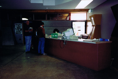
Photograph - Temporary City of Port Melbourne library, Howe Parade, Jan 1988
Two colour photos of the Port Melbourne library building situated in the former laboratory block of BP Oil Company, Howe Parade, whilst the new library was being built on the supermarket site. January 1988built environment - civic, built environment - industrial, port melbourne library, bp australia, howe parade -
Port Melbourne Historical & Preservation Society
Photograph - New amenenities block, J Kitchen & Sons Pty Ltd, Port Melbourne, Laurie Richard, Aug 1957
10 black and white photos taken after new amenities block was occupied 19th August 1957. Include canteen, library,cycle racks, locker room, watchman's office, health centre, management dining room, conference room.Laurie Richard JW 1528industry - manufacturing, workers, j kitchen & sons pty ltd, unichema australia pty ltd -
 Bendigo Historical Society Inc.
Ephemera - HARRY BIGGS COLLECTION: ENVELOPE
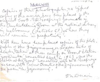
Cream coloured envelope with cello tape on the back with some rust marks.. On the front hand written in blue ink by S. M. Deravin writes about the photo's in the envelope. It is entitled 'Aboriginies' Copies of these photographs and a typed copy of the verses have been placed in the original book - F. R. Godfrey's journals in the Australiana Room at the National Library in Melbourne (Latrobe St) where they will remain 'in perpetuity'. With them have been placed copies of the photographs of the Jajoweroung or Loddon tribe of blacks, taken at their camp on 'Boort Station' (now 'Dunbar' homestead block) in 1963 and the stables at the 'Boort' homestead with M. H. Godfrey and his sons, with Prince Charlie of the Jajoweroung and of the poem 'The Jajoweroung' These photos and descriptions are in 2400.419a and 419b, also 2400 420a and 420b.S. M. Deravinphilately, postal stationary, aborigines, f. r. godfrey, 'dunbar', 'boort homestead' jajoweroung, s.m. deravin. -
 Stanley Athenaeum & Public Room
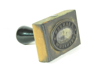
Tool - Rubber Stamp, Library stamp, C mid 20th Century
Used by the librarian in the mid 20th Century to stamp each new book at the Stanley Athenaeum, the stamp identified the library's ownership of the books in the library. The stamp is still used today when new books are acquired by the Stanley Athenaeum. This item is historically significant as part of the Stanley Athenaeum collection and can be used to identify the age of books and when they were acquired by the Stanley AthenaeumWooden block with wooden handle and inscribed rubber stamp on front faceInscribed relief in elliptical shape with words and stars in reverse. "Stanley Athenaeum" stanley, stanley athenaeum, stamp, ownership -
 St Kilda Historical Society
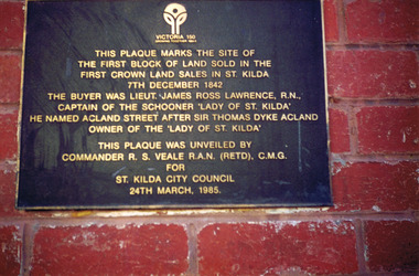
Photograph, Plaque marking the site of the first block of land sold in the first Crown Land Sales in St Kilda 7 Dec 1842, c. 1980s?
colour photograph unmounted (2 identical photographs)This plaque marks the site of the first block of land sold in the first Crown Land Sales in St Kilda 7 Dec 1842. The buyer was Lieut. James Ross Lawrence, R N, Captain of the Schooner 'Lady of St Kilda'. He named Acland st after Sir Thomas Dyke Acland, owner of "The Lady of St Kilda". This plaque was unveiled by Commander RS Veale RAN (retd) CMG for St Kilda City Council. 24 March 1985. -
 St Kilda Historical Society
Photograph, St Kilda Library alterations 1993-94 - images collection, 1994
St Kilda Library was designed in 1971 by Enrico Taglietti (1926-2019). It was to be constructed in two stages. Stage 1 was completed in 1973. Stage 2 as designed by Taglietti did not proceed. Instead, alterations were designed in 1992-93 by Ashton Raggatt McDougall Architects (ARM). In 1993-94, the floor area of the library was enlarged to include a new entry and disabled ramp and a pedestrian thoroughfare between Carlisle and Duke streets. The original entry was blocked and a bluestone 'book' wall was constructed west of the new entry.colour photograph unmountedSK Libraryst kilda library, enrico taglietti, arm architects -
 St Kilda Historical Society
Photograph, Majestic Hotel St Kilda after 1981 fire - images collection, 22/08/1981
Fire at the building on 22 August 1981. The building was constructed in 1912 as a block of flats, designed and built by JRDaley, and it was renovated in the 1930s. After the fire, most of the rear of the building was demolished and replaced by modern apartments. Colour photographst kilda, majestic hotel, majestic, fitzroy street -
 St Kilda Historical Society
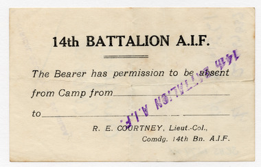
Ephemera - Permit, 14th Battalion AIF permit, 1914-1915
Permit for permission to be absent from camp. Lieutenant Colonel Richard Edmond Courtney CB, VD, whose signature block appears on the permit, was the Commanding Officer for the period August 1914-1915, including the Gallipoli Campaign. Cream-coloured paper document, printed in black on one side, over-stamped in purple inkOver-stamped: 14th BATTALION A.I.F.wwi, 14th battalion aif, richard edmond courtney -
 St Kilda Historical Society
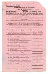
Administrative record - Form, War Census
For a census of wealth and income during World War IPink coloured paper form, single sheet, printed in block on both sides1915 census -
 St Kilda Historical Society
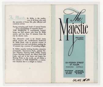
Ephemera - Flyer, Majestic Private Hotel, c1940s
Advertisement for the Majestic Private Hotel, 151 Fitzroy Street St Kilda. The building was constructed in 1912 as a block of flats, designed and built by JR Daley, and was renovated in the 1930s. After a fire in 1981, most of the rear of the building was demolished and replaced by modern apartments.White paper printed in black on both sides, and some teal, and laminatedmajestic hotel, fitzroy street -
 St Kilda Historical Society
Photograph, Donald McDonald, Herford, 1872
Large residence on large elevated block for Frederick Christian Lange (1832-1888) and family in 1870. The architect Lloyd Tayler (1830-1900) designed it in an Italianate style. Over time adjoining allotments were purchased until the gardens covered nearly 15 acres. Lange was in partnership with Emil Thoneman trading under the name of Lange & Thoneman, merchants and general importers. Lange was also one of the local directors of the local Australasian directors for the Swiss Lloyd Marine Insurance Company. William Officer (1835-1913), pastoralist, bought the property from Lange in 1888 for 23,500 pounds. Following Officer's death the grounds were subdivided in 1914 and the house finally demolished in 1940. Noting the spelling difference, there is now a street named 'Hertford Street' very close to this location. black and white photograph copyAlma Road south west corner Lansdowne Road built for Federick C Lange (Merchant) Photo 1872 -
 St Kilda Historical Society
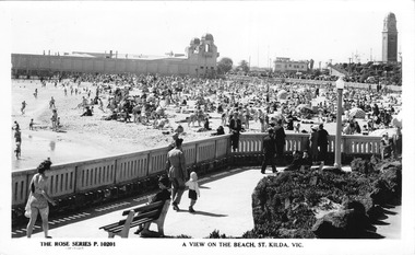
Photograph, Rose Series Postcard, St Kilda Beach, 1940-1960
St Kilda Sea Baths, Yacht Club, Catani Tower, Alfred Sq 1970s modernist tower block, beach in foregroundblack and white postcard, unmounted, original, good conditionA View on the Beach, St Kilda.Vic -
 St Kilda Historical Society
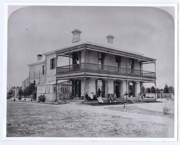
Photograph, Millar's Hotel, c. 1840 ?
black and white photograph mounted, fair conditionHand written on the back: Mooney's Royal Hotel, cnr Robe Street and Esplanade in the 1840s. Belvedere block of flats built 1929 (Hotel reads "Millar's Royal Hotel" on front of photograph) -
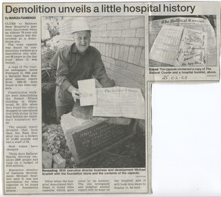 Ballarat Base Hospital Trained Nurses League
Ballarat Courier - Later Hospital Misc - eg. Building etc
Newspapertb, chalet, outpatients, bolte, wing, library, rowe, time, capsule, 1935, discovered, 2003, demolition, wilson, building, yuille, house, 2016, emergency, department, entrance, ballarat base hospital, north block, drummond, mair, public, open, day,1992 -
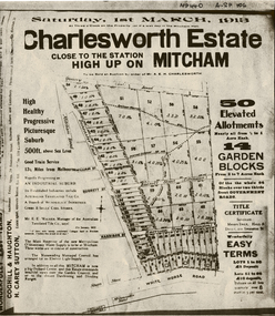 Whitehorse Historical Society Inc.
Document, Charlesworth Estate, 1913
Charlesworth Estate, Mitcham. 50 elevated allotments, 1/2 to 1 acre each and 14 garden blocks from 2 to 7 acres each. 1 March 1913.Brochure for auction of Charlesworth Estate, Mitcham. 50 elevated allotments, 1/2 to 1 acre each and 14 garden blocks from 2 to 7 acres each. 1 March 1913. Agents: Coghill & Houghton and H. Carey Sutton.Charlesworth Estate, Mitcham. 50 elevated allotments, 1/2 to 1 acre each and 14 garden blocks from 2 to 7 acres each. 1 March 1913.auctions, charlesworth estate, mitcham, quarry road, doncaster east road, burnett street, harrison street, whitehorse road -
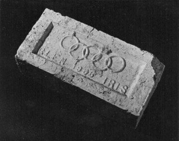 Whitehorse Historical Society Inc.
Memorabilia - Brick, 1956
The brick was used in the construction of a toilet block located behind the Blackburn Library and next to the railway line. it was donated by the City of Whitehorse after the toilet block was demolished in 1999.1956 Olympic Glen Iris cream brick'Glen 1956 Iris' with Olympic ringsbuildings, materials -
Whitehorse Historical Society Inc.
Newspaper - Article, Book closes on career, 18/08/1993
... Article by Andrew Block on Blackburn Library Branch... Article by Andrew Block on Blackburn Library Branch Librarian ...Article by Andrew Block on Blackburn Library Branch Librarian on her retirement.wolstenholme, pat, blackburn branch library -
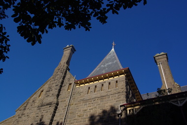 Ballarat Heritage Services
Photograph - Image - Colour, Clare Gervasoni, Bishop's Palace Ballarat Featuring Chimneys and Roof Line, Ballarat, 2014, 23/02/2014
Bishops Palace was built in 1877 as the home for the first Catholic Bishop of Ballarat. Designed by Melbourne architect, Joseph Reed, of Reed and Barnes, it was built by George Broom at a cost of £6,000. Reed and Barnes also designed Melbourne’s State Library, Ripponlea Estate and the Melbourne Royal Exhibition Building. The original heritage-listed gold lead stencilled paintwork that can be seen in the front entry and on the staircase walls at Bishops Palace was replicated in the Royal Exhibition Building. The original property was 140 squares set on 11 acres of gardens and took up an entire block of Sturt Street. This was on scale with the importance of Ballarat as a gold-mining centre at the time. Bishop's Palace is of architectural, aesthetic and historical significance to the State of Victoria. The two-storey bluestone mansion is an impressive example of 19th-century Gothic architecture with an unusual design. It retains many of its original features, including lead stencilled paintwork, cornices, ceiling roses, fixtures and fittings. Since sold by the Catholic Church the Bishops Palace has undergone a number of transformations in its lifetime, from the home of the first Bishop to a private residence, and today, as a luxurious accommodation, wedding and events venue. The grounds were subdivided over the years, and the property is now surrounded by four of the original 11 acres of gardens. It opened its doors to the public in 2019.Colour image of the bluestone Bishop's Palace, and it's cast iron lace.architecture, garden, bishop's palace, cast iron lace, cast iron, catholic church -
Ballarat Heritage Services
digital copy, Ballarat East High School Magazine 1960, 1960
School History: In February, 1955, Ballarat East High School opened in Hopetoun Street, in the vacated weatherboard buildings of the Girls’ Secondary School. In 1956, however, the School moved to its present site in Fussell Street, but because of the lack of space, Woodwork and Cookery classes were still held at Hopetoun Street. Since then there has been steady progress. The original building was extended, more classrooms and a library being built. A Domestic Science block was completed in 1957. Later, as mentioned elsewhere, sheltersheds, basketball courts, a bidycle shed and a canteen were provided for the pupils from funds raised by the Parents’ Association. Where there were previously bare areas of clayey soil we now have asphalt paths and neat gardens. Shrubs were planted, and seats, painted in the School colours, were places around the asphalted areas. (Page 5, 1959 BEHS School Magazine) 3 pdf files containing multiple pages of the BEHS 1960 School Magazinebehs, ballarat east high school, ballarat east, magazine, 1960 -
Ballarat Heritage Services
digital copy, Ballarat East High School Magazine 1961, 1961
School History: In February, 1955, Ballarat East High School opened in Hopetoun Street, in the vacated weatherboard buildings of the Girls’ Secondary School. In 1956, however, the School moved to its present site in Fussell Street, but because of the lack of space, Woodwork and Cookery classes were still held at Hopetoun Street. Since then there has been steady progress. The original building was extended, more classrooms and a library being built. A Domestic Science block was completed in 1957. Later, as mentioned elsewhere, sheltersheds, basketball courts, a bidycle shed and a canteen were provided for the pupils from funds raised by the Parents’ Association. Where there were previously bare areas of clayey soil we now have asphalt paths and neat gardens. Shrubs were planted, and seats, painted in the School colours, were places around the asphalted areas. (Page 5, 1959 BEHS School Magazine) 3 pdf files of multiple pages of BEHS School magazine=1961 behs, ballarat east high school, ballarat east, magazine, 1961 -
Ballarat Heritage Services
digital copy, Ballarat East High School Magazine 1962
School History: In February, 1955, Ballarat East High School opened in Hopetoun Street, in the vacated weatherboard buildings of the Girls’ Secondary School. In 1956, however, the School moved to its present site in Fussell Street, but because of the lack of space, Woodwork and Cookery classes were still held at Hopetoun Street. Since then there has been steady progress. The original building was extended, more classrooms and a library being built. A Domestic Science block was completed in 1957. Later, as mentioned elsewhere, sheltersheds, basketball courts, a bidycle shed and a canteen were provided for the pupils from funds raised by the Parents’ Association. Where there were previously bare areas of clayey soil we now have asphalt paths and neat gardens. Shrubs were planted, and seats, painted in the School colours, were places around the asphalted areas. (Page 5, 1959 BEHS School Magazine)4 pdf files holding multiple pages of BEHS 1962 School Magazines. These are large pdf files being each around 20MB or largerbehs, ballarat east high school, ballarat east, magazine, 1962 -
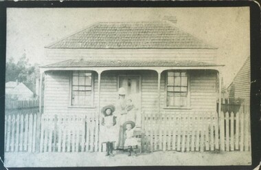 City of Ballarat Libraries
Photograph - Card Box Photographs, Mother and children stand out the front of a cottage in Otway Street North, Ballarat circa 1881
The cottage was the second block from Victoria Street and around the corner from Dytes Parade.building, private dwelling, people, costume, otway street -
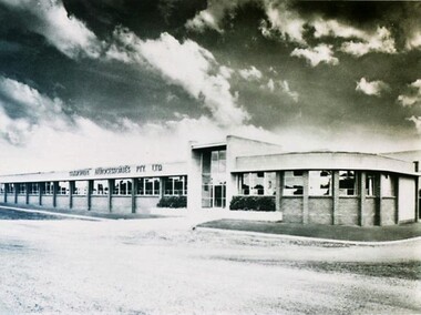 City of Ballarat Libraries
Photograph - Card Box Photographs, Simmonds Aerocessories Building, Ballarat circa 1960
The Administration block for Simmonds Aerocessories Pty Ltd was located on Latrobe Street. This was part of the Guncotton Industrial Estate.simmonds aerocessories pty ltd, guncotton industrial estate, building, manufacturing, streetscape, latrobe street -
 Kew Historical Society Inc
Plan, Melbourne & Metropolitan Board of Works : Borough of Kew : Detail Plan No.1576, 1904
The Melbourne and Metropolitan Board of Works (MMBW) plans were produced from the 1890s to the 1950s. They were crucial to the design and development of Melbourne's sewerage and drainage system. The plans, at a scale of 40 feet to 1 inch (1:480), provide a detailed historical record of Melbourne streetscapes and environmental features. Each plan covers one or two street blocks (roughly six streets), showing details of buildings, including garden layouts and ownership boundaries, and features such as laneways, drains, bridges, parks, municipal boundaries and other prominent landmarks as they existed at the time each plan was produced. (Source: State Library of Victoria)This plan forms part of a large group of MMBW plans and maps that was donated to the Society by the Mr Poulter, City Engineer of the City of Kew in 1989. Within this collection, thirty-five hand-coloured plans, backed with linen, are of statewide significance as they include annotations that provide details of construction materials used in buildings in the first decade of the 20th century as well as additional information about land ownership and usage. The copies in the Public Record Office Victoria and the State Library of Victoria are monochrome versions which do not denote building materials so that the maps in this collection are invaluable and unique tools for researchers and heritage consultants. A number of the plans are not held in the collection of the State Library of Victoria so they have the additional attribute of rarity.Original survey plan, issued by the MMBW to a contractor with responsibility for constructing sewers in the area identified on the plan within the Borough of Kew. The plan was at some stage hand-coloured, possibly by the contractor, but more likely by officers working in the Engineering Department of the Borough and later Town, then City of Kew. The hand-coloured sections of buildings on the plan were used to denote masonry or brick constructions (pink), weatherboard constructions (yellow), and public buildings (grey). Development in the 20th century has irreparably altered that part of Kew represented in this plan. In the block bounded by Cotham Road, Charles Street, Wellington Street and Gellibrand; just one house standing in 1903 remains. This block included two of the most historic houses in Kew: ‘Ordsall’ (later ‘Southesk’) and ‘Madford’ (previously ‘Elm Lodge’). Ordsall was the home of the second chairman of Kew, John Halfey. It contained some of the most significant interior murals in Kew, created for Halfey by artists working for Cullen & Co. It was demolished in 1960 to make way for the Kew Civic Centre. Elm Lodge had been built for William Siddeley in ca. 1864. Arthur Septimus King purchased it in 1874. The lower paddocks of Madford were sold in 1905 by his wife to the Borough of Kew and, after landscaping by George and Thomas Pockett, opened as the Alexandra Gardens in 1908. Elm Lodge/Madford was in 1922 to become St. Anthony’s Home for Little Children before its subsequent demolition in the 1980s.melbourne and metropolitan board of works, detail plans, maps - borough of kew, mmbw 1576, cartography -
 Kew Historical Society Inc
Plan, Borough of Kew Detail Plan No.1577, 1904
The Melbourne and Metropolitan Board of Works (MMBW) plans were produced from the 1890s to the 1950s. They were crucial to the design and development of Melbourne's sewerage and drainage system. The plans, at a scale of 40 feet to 1 inch (1:480), provide a detailed historical record of Melbourne streetscapes and environmental features. Each plan covers one or two street blocks (roughly six streets), showing details of buildings, including garden layouts and ownership boundaries, and features such as laneways, drains, bridges, parks, municipal boundaries and other prominent landmarks as they existed at the time each plan was produced. (Source: State Library of Victoria)This plan forms part of a large group of MMBW plans and maps that was donated to the Society by the Mr Poulter, City Engineer of the City of Kew in 1989. Within this collection, thirty-five hand-coloured plans, backed with linen, are of statewide significance as they include annotations that provide details of construction materials used in buildings in the first decade of the 20th century as well as additional information about land ownership and usage. The copies in the Public Record Office Victoria and the State Library of Victoria are monochrome versions which do not denote building materials so that the maps in this collection are invaluable and unique tools for researchers and heritage consultants. A number of the plans are not held in the collection of the State Library of Victoria so they have the additional attribute of rarity.Original survey plan, issued by the MMBW to a contractor with responsibility for constructing sewers in the area identified on the plan within the Borough of Kew. The plan was at some stage hand-coloured, possibly by the contractor, but more likely by officers working in the Engineering Department of the Borough and later Town, then City of Kew. The hand-coloured sections of buildings on the plan were used to denote masonry or brick constructions (pink), weatherboard constructions (yellow), and public buildings (grey). MMBW Plan No.1577 includes some of the most significant houses in Kew: Herbert Henty’s ‘Roxeth’ (now part of Trinity Grammar), ‘Butleigh Wooton’, ‘Bokara’ and ‘Harrow’. It also includes the streets that have since changed their names. That part of College Parade linked to Glenferrie Road is now named College Place, College Parade now extends further north, and Charles Street did not yet reach Barkers Road. Roxeth is one of a number of Henty houses in Kew. Herbert Henty made his home here and was elected a member of Kew Municipal Council in 1864 and mayor in 1868-69. Walter Henry Serle, of Harrow served in the First World War. He was awarded the Military Medal ‘’For conspicuous bravery and devotion to duty. On 29th September near BELLICOURT he showed the greatest bravery and determination when his platoon was attacked by enemy bombing parties. It was due largely to his personal efforts that all the attacks were repulsed. Until wounded, his utter disregard of personal safety and boldness in dealing with the attacks were the means of saving the situation and were an inspiring example to his men.’melbourne and metropolitan board of works, detail plans, maps - borough of kew, mmbw 1577, cartography -
 Kew Historical Society Inc
Plan, Melbourne & Metropolitan Board of Works : Borough of Kew : Detail Plan No.1578, 1904
The Melbourne and Metropolitan Board of Works (MMBW) plans were produced from the 1890s to the 1950s. They were crucial to the design and development of Melbourne's sewerage and drainage system. The plans, at a scale of 40 feet to 1 inch (1:480), provide a detailed historical record of Melbourne streetscapes and environmental features. Each plan covers one or two street blocks (roughly six streets), showing details of buildings, including garden layouts and ownership boundaries, and features such as laneways, drains, bridges, parks, municipal boundaries and other prominent landmarks as they existed at the time each plan was produced. (Source: State Library of Victoria). This plan forms part of a large group of MMBW plans and maps that was donated to the Society by the Mr Poulter, City Engineer of the City of Kew in 1989. Within this collection, thirty-five hand-coloured plans, backed with linen, are of statewide significance as they include annotations that provide details of construction materials used in buildings in the first decade of the 20th century as well as additional information about land ownership and usage. The copies in the Public Record Office Victoria and the State Library of Victoria are monochrome versions which do not denote building materials so that the maps in this collection are invaluable and unique tools for researchers and heritage consultants. A number of the plans are not held in the collection of the State Library of Victoria so they have the additional attribute of rarity.Original survey plan, issued by the MMBW to a contractor with responsibility for constructing sewers in the area identified on the plan within the Borough of Kew. The plan was at some stage hand-coloured, possibly by the contractor, but more likely by officers working in the Engineering Department of the Borough and later Town, then City of Kew. The hand-coloured sections of buildings on the plan were used to denote masonry or brick constructions (pink), weatherboard constructions (yellow), and public buildings (grey). MMBW Plan No.1578 is significant in that it defines the extent of two private schools: Xavier College and Kew High School (now part of Trinity Grammar) by 1904. In relation to the latter, the plan clarifies which buildings the High School operated from behind the mansion ‘Molina’. Established in 1902, Trinity Grammar was to later lease and subsequently buy Molina (now ‘Merritt House’) and ‘Elsinore’ (now ‘Roberts House’). Xavier College had been established in 1872. This 1904 plan delineates the West Wing and the Great Hall (built in 1890).melbourne and metropolitan board of works, detail plans, maps - borough of kew, mmbw 1578, cartography -
 Kew Historical Society Inc
Plan, Melbourne & Metropolitan Board of Works. Borough of Kew Detail Plan No.1579, 1904
The Melbourne and Metropolitan Board of Works (MMBW) plans were produced from the 1890s to the 1950s. They were crucial to the design and development of Melbourne's sewerage and drainage system. The plans, at a scale of 40 feet to 1 inch (1:480), provide a detailed historical record of Melbourne streetscapes and environmental features. Each plan covers one or two street blocks (roughly six streets), showing details of buildings, including garden layouts and ownership boundaries, and features such as laneways, drains, bridges, parks, municipal boundaries and other prominent landmarks as they existed at the time each plan was produced. (Source: State Library of Victoria). This plan forms part of a large group of MMBW plans and maps that was donated to the Society by the Mr Poulter, City Engineer of the City of Kew in 1989. Within this collection, thirty-five hand-coloured plans, backed with linen, are of statewide significance as they include annotations that provide details of construction materials used in buildings in the first decade of the 20th century as well as additional information about land ownership and usage. The copies in the Public Record Office Victoria and the State Library of Victoria are monochrome versions which do not denote building materials so that the maps in this collection are invaluable and unique tools for researchers and heritage consultants. A number of the plans are not held in the collection of the State Library of Victoria so they have the additional attribute of rarity.Original survey plan, issued by the MMBW to a contractor with responsibility for constructing sewers in the area identified on the plan within the Borough of Kew. The plan was at some stage hand-coloured, possibly by the contractor, but more likely by officers working in the Engineering Department of the Borough and later Town, then City of Kew. The hand-coloured sections of buildings on the plan were used to denote masonry or brick constructions (pink), weatherboard constructions (yellow), and public buildings (grey). While MMBW Plan No.1579 does not include many buildings, those that it does show are significant to Kew’s history. These include the ‘Kew [Railway] Station’ in Denmark Street and the ‘Recreation Hall’ and rear courts off Wellington Street. The plan shows the outline of the Recreation Hall, constructed in 1880, at the rear of which is listed a bowling green, two tennis courts, a ‘skittle alley’ and a pavilion. When the Hall was first built, the Kew Cricket Club occupied an adjacent ground, however in 1885 this was acquired by the State Government as the future location of the Kew Railway Station. The Plan also shows a single oval at Xavier College. This oval was completed in 1883. One of the current ovals conforms to this oval’s original shape and position in the school grounds.melbourne and metropolitan board of works, detail plans, maps - borough of kew, mmbw 1579, cartography -
 Kew Historical Society Inc
Plan, Melbourne and Metropolitan Board of Works, Borough of Kew : Detail Plan No.1580, 1904
The Melbourne and Metropolitan Board of Works (MMBW) plans were produced from the 1890s to the 1950s. They were crucial to the design and development of Melbourne's sewerage and drainage system. The plans, at a scale of 40 feet to 1 inch (1:480), provide a detailed historical record of Melbourne streetscapes and environmental features. Each plan covers one or two street blocks (roughly six streets), showing details of buildings, including garden layouts and ownership boundaries, and features such as laneways, drains, bridges, parks, municipal boundaries and other prominent landmarks as they existed at the time each plan was produced. (Source: State Library of Victoria)This plan forms part of a large group of MMBW plans and maps that was donated to the Society by the Mr Poulter, City Engineer of the City of Kew in 1989. Within this collection, thirty-five hand-coloured plans, backed with linen, are of statewide significance as they include annotations that provide details of construction materials used in buildings in the first decade of the 20th century as well as additional information about land ownership and usage. The copies in the Public Record Office Victoria and the State Library of Victoria are monochrome versions which do not denote building materials so that the maps in this collection are invaluable and unique tools for researchers and heritage consultants. A number of the plans are not held in the collection of the State Library of Victoria so they have the additional attribute of rarity.Original survey plan, issued by the MMBW to a contractor with responsibility for constructing sewers in the area identified on the plan within the Borough of Kew. The plan was at some stage hand-coloured, possibly by the contractor, but more likely by officers working in the Engineering Department of the Borough and later Town, then City of Kew. The hand-coloured sections of buildings on the plan were used to denote masonry or brick constructions (pink), weatherboard constructions (yellow), and public buildings (grey). The area represented in this detail plan has undergone significant change during the 20th century. The widening of High Street in the 1930s and 1950s involved the shops on the south side of High Street being demolished and later rebuilt to fit the widened street. Another significant loss was the mansion ‘Drayton’ fronting Wellington Street, owned at this stage by Susannah Fenton. Her family name would later to be given to Fenton Way, which was to be built over the grounds of the house following its demolition. The plan of the garden is particularly interesting, containing a batten dome fronting Wellington Street, an ornamental pond, a fountain and a brick and glass conservatory. The notes by the plumbing contractor on this plan are particularly detailed. Pink borders delineate the ownership of the varying parcels of land. Some of the better known owners listed include the real estate agent Cr. Henry de Castres Kellett (bt) and John Padbury, the funeral director. This particular plan provides a clear view of the configuration of the Kew Junction in 1903 and the commercial buildings that surrounded it.melbourne and metropolitan board of works, detail plans, maps - borough of kew, mmbw 1580, cartography