Showing 168 items
matching main highway
-
 Eltham District Historical Society Inc
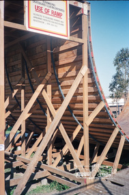
Photograph, Nunawading Skateboard Club ramp, c.1985, 1985c
Now the Vermont South Skateboard Ramp, cnr Burwood Highway and Morack Road.Roll of 35mm colour negative film, 2 stripsFuji 100nunawading skateboard club, skate park, vermont south skateboard ramp -
 Glen Eira Historical Society
Book - Local Government Act First Report of the Assistant Commissioner of Roads and Bridges
This file contains 1 item: 1/The Local Government Act, First Report of the Assistant Commissioner of Roads and Bridges, printed by order of the Victorian Legislative Assembly on 08/03/1865. The document is the first annual report of John Steavenson, Assistant Commissioner of Roads and Bridges under s330 of the Local Government Act no. 176 (1863), and relates to transactions which took place from 02/09/1863 to 31/12/1864. The report outlines operations carried out by the Department of Roads and Bridges in this period. In the Glen Eira area this includes: separating electoral subdivisions of single districts (Moorabbin), adding detached portions of territory to road districts and shires (Caulfield), appointing of and altering in polling places, appointing of polling places for ridings of shires and subdivisions of road districts (Moorabbin), preparing and transmitting of forms of books also of pro forma accounts for guidance of local bodies in keeping their accounts, appointment of main roads, construction of a main road, ‘Dandenong’, in the Caulfield and Gardiner districts, proclaiming of Common Toll Roads, names of and security given by Managers of Common Toll Roads. The report also gives some information about the Shire of Caulfield, which contained 24 road districts and 340 rate payers in 8¼ square miles, and the Shire of Moorabbin, which contained 62 road districts and 713 rate payers in 30 square miles.local government act, assistant commissioner of roads and bridges, legislative council, caulfield historical soceity, steavenson john, sullivan j. f. the honourable, caulfield, moorabbin, road districts, point nepean road, nepean highway, dandenong road, princes highway, brown edwin, osher joseph, cosgrove john, ferres john, roads and bridges offices, caulfield roads district, moorabbin roads district, road construction and maintenance, roads and streets, acts of parliament -
Glen Eira Historical Society
Document - GARDENVALE
This file contains two items about Gardenvale, which was previously all part of Caulfield: 1/Photocopied eight page document by M. Stewart, 1961, entitled ‘The Gardenvale Story’. It describes Gardenvale Railway and surrounding roads and land. Lempriere’s Paddock, rail tracks on the main roads for the use of market gardeners’ wagons. Sale of land for O’Neill College Estate and construction of a subway through the railway embankment to Gardenvale Shopping centre, including efforts by local people and the council for work to be completed and costs. Footnote is circa 1977. 2/Map of Glen Eira printed from Council website 20/06/2014 showing Glen Eira’s share of Gardenvale.gardenvale, bent thomas, brighton, caulfield, elsternwick, railway stations, lempriere family, ‘bentville’, lempriere’s paddock, market gardens, nepean highway, nepean road, north road, kooyong road, polo, sheridan family, bluestone houses, bethlehem hospital, land subdivision, begonia street, gardenia road, gardenia street, magnolia street, lantana street, martin street, shops, ‘ben burb’, house names, padua hospital, brighton, o’neill miss, o’neill college, o’neill richard, o’neill estate, elster avenue, o’neill college estate, railway crescent, denver crescent, brentani avenue, college street, rosstown railway, brighton cemetery, ross mr, hawthorn road, ormond, gardenvale progress association, elster creek, parliamentary representatives, landscapes, gardenvale road, railway lines, subways, traders association, drainage, floods -
 Ringwood and District Historical Society
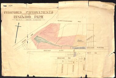
Map, Proposed Improvements to Ringwood Park (Ringwood Lake) dated 14 January 1927
Proposed Improvements to Ringwood Park (Ringwood Lake) dated 14 January 1927, signed Cr McCaskill. Main Road is Whitehorse Road (Maroondah Highway), and Mt Dandenong Road is incorrectly labelled Whitehorse Road. The map shows Rosedale Crescent and Railway Parade, both of which exist in 2024. On the bottom of the map, south of the railway line, showing proposed streets - Graham Road, Anderson Street and Adams Street - in preparation for the sale of the Theo Anderson property. That area is now Bedford Park. -
 Ringwood and District Historical Society
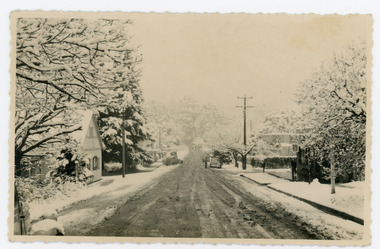
Photograph, Maroondah Highway West, Ringwood- c1924. Kenworthy Coach Builder & General Smith
Black and white photograph (1 original, 2 copies)Typed below one copy: "Blacksmiths shop in Maroondah Hwy" Written on back of original copy: "Given to me by Mr Kenworthy- Mr McCaskill. Removed from Main Road & Adelaide St. Cnr Wantirna Rd and Main St. -
 City of Moorabbin Historical Society (Operating the Box Cottage Museum)
Photographs,x3 Colour Early Weatherboard Cottage Cheltenham c1880, 1981
Henry Dendy , a farmer from Sussex England, purchased 5,120 acres of land in the area of a 'Special Survey 1841' that extended from Brighton bayside North Road, East Boundary Rd to South Road. This area became known as Dendy's Brighton and as part of the sale 139 emigrant workers arrived in 1842 however Dendy was unable to find work and lodgings for these people. J.B.Were, financier took over the management of the 'Special Survey 1841' area and began to sell and lease allotments. 1850 the Squatter King brothers sold land south of Dendy's 'Special Survey 1841' to Josiah Holloway who sectioned it into 2 acre lots @ £10 each for market gardens - 'Two Acre Village' and Charles Whorral opened a small hotel - 'The Cheltenham Inn' on the main Road - Arthur's Seat Rd, later Point Nepean Rd, now Nepean Highway. Notable settlers who moved into the area were Keys, Charman, Bruton, Le Page, Fairlam, Meeres and 1862 saw the separation from Brighton and the formation of the Mooorabbin Roads Board District. .By 1879 1000settlers were living in 'Cheltenham' serviced by a Post Office with Bank, Mechanics Institute, State School No 84,Keys Hotel, Meeres Store, Sir Thomas Bent ensured the new Railway Line from Caulfield to Mordialloc went through his constituency of Cheltenham 1881 and this changed the development to the bayside area of Cheltenham away from the 'Two Acre Village ' side causing some dissention, However Cheltenham as whole prospered and this house in Pine St is typical of the cottages built c 1890- 1900 in the area. This weatherboard house c 1890-1900 in Pine St Cheltenham is typical of those built for early settler families. Photo taken 1981 by CMHS member 3 x Colour photographs of an early c 1900 weatherboard house in Pine St Cheltenham taken by CMHS member 1981Kodak Aug. 81 / Handwritten Pine St Cheltenhamkeys robert, holloway josiah, king brothers, smith j l; smith mary ann, stanley helen, chaff cutter, horse drawn carts, toll gates brighton, motor cars 1900, steam engines, early settlers, bentleigh, parish of moorabbin, city of moorabbin, county of bourke, moorabbin roads board, shire of moorabbin, henry dendy's special survey 1841, were j.b.; bent thomas, o'shannassy john, king richard, charman stephen, highett william, ormond francis, maynard dennis, market gardeners, vineyards, orchards -
 City of Moorabbin Historical Society (Operating the Box Cottage Museum)
Photograph - Plateway (Wheelway) Steel, circa 1885
By the later 1800s the dirt roads in the then out-lying areas of the City of Moorabbin became dangerous, and almost impassable due to huge potholes and muddy swampy areas. The heavily laden market gardener’s carts regularly broke axles and wheels, and horses foundered on their way to the Melbourne markets. Even worse, the heavier “iron maidens”, carrying their malodorous loads of sewage from Melbourne’s inner suburbs for dumping in the outlying areas of the City of Moorabbin, also got bogged in the mire. It was decided that a practical solution to this problem was to install a metal plateway on the side of the problematic roads. In about 1887 the Moorabbin Shire Centre Road, in the Brighton East area, two parallel metal rails were installed so that the wheels of carts could run along smoothly, the horse travelled in the filled, middle area between the rails. Point Nepean Road plateway was removed in 1930 and Centre Dandenong Road plateway was removed in 1934-35. The worn plateway along Centre Road, East Brighton (now known as Bentleigh), was gradually taken up in several pieces, commencing in the the1920s, when its condition deteriorated and it caused a hazard to bikes, pedestrians, motor-cycles and the few early cars. The early steel plateway, constructed by David Munro, and opened on 23rd March 1885 by Thomas Bent, was built along Nepean Highway, between Asling St. and Bay St. The Point Nepean Track was subsequently extended into Moorabbin with branches along Centre, Cumins, South, Wickham, and Keys Roads, the total length was 13 miles. In 1908-1909 plates were laid along Centre Dandenong Road to Ross Street Bentleigh This innovative solution proved successful and was used until gradually the main roads were upgraded, and motorised vehicles started to appear. Two parallel metal rails were installed in the right hand side of a few main roads in the Shire of Moorabbin so that the wheels of heavily-loaded market gardener's carts on their way to markets in Melbourne could run along smoothly. The horse pulling the carts travelled in the filled, middle area between the rails. The Steel Plateway was constructed by David Munro, and opened on 23rd March 1885 by Thomas Bent. The wheelway first only ran along Nepean Highway, but it soon extended from Centre Dandenong Road, along Nepean road to its junction with Chapel Street, St Kilda. Later branch lines were built along Centre Road, Bentleigh as far as Warrigal Road and, according to early photographs, along Wickham Road Moorabbin as well. This innovative solution proved successful and was used until gradually the main roads were upgraded, and motorised vehicles started to appear. There was a problem with the wheelway : there was only a single set of rails and this was established on the right-hand side of the Nepean Road, travelling towards the city. Traffic FROM the city travelled on the correct or left-hand side of the road. The exception to this rule was the malodorous iron-clads, heavily riveted iron carts, generally travelling in convoy, carrying several tons of human effluent out of Melbourne to be trenched-in in the sandy soil of the Moorabbin district. Moorabbin City Council donated and installed a small section of Plateway at Box Cottage Museum in 1984melbourne, brighton, moorabbin, roads, plateway, wheelway, transport, st kilda, bent thomas, munro david, market gardens, steelway, carts horse-drawn, iron maidens, point nepean track -
 Bendigo Historical Society Inc.
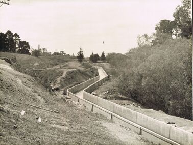
Photograph - JOSEPH BRADY COLLECTION: FLUMING BETWEEN MALMSBURY RESERVOIR AND CALDER HIGHWAY, 1934
Black and white photograph: image shows concrete channel snaking down hill, top LH side appears to be bluestone mill with tall chimney. Trees on RH side of channel. Comments on the back of the photo 'Between Malmsbury Res and Calder Hwy. 8 feet wide 4 foot 6 inches deep. Taken 1934. JA 10/81 concrete grand fluming at 12.5 miles Main channel 8 feet wide 4 foot 6 inches high. Constructed 1928.'place, water, coliban race, john brady collection. coliban race -
 Lake Bolac & District Historical Society
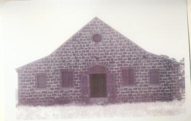
Black and white photograph, Lake Boloke Station woolshed
The Lake Boloke Station bluestone woolshed is located 4 kilometres north of Lake Bolac on the Back Bolac Road. Originally the main woolshed for the station. It was built by Robert Patterson in the mid 1860's but later owned by the Wills Family, as 'Fintry', following the subdivision of Lake Boloke Station.Black and white photographlake boloke, woolshed, bluestone, wills family, patterson, fintry -
 Lake Bolac & District Historical Society
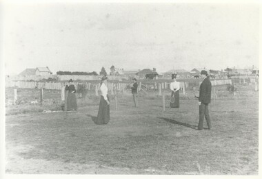
Black and white photograph, Lake Bolac, original tennis court, 1895
The original tennis court at Lake Bolac in 1895 was located at the Recreation Reserve behind the linear development along the main road. This was a grass court, lines were clearly painted and the tennis-net was a chicken-wire fence. In the photograph are from left; Eva Veale, Alice Veale, Thomas Ward, Annie Veale and William Veale jr.lake bolac, tennis, veale, ward -
 Lake Bolac & District Historical Society
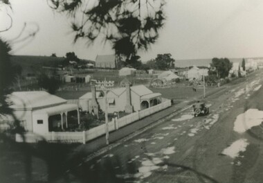
Black and white photograph, Wickliffe, main street, circa 1920
Wickliffe, main street, taken from pine tree opposite the hotel. Presbyterian Church on the hill centre-left. 1920's.wickliffe, main street. -
 Stawell Historical Society Inc
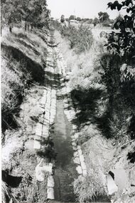
Photograph, Main Drain - Napier Street to Western Highway
... grampians Main Drain - Napier Street to Western Highway Stawell Main ...Main Drain - Napier Street to Western Highwaystawell -
Whitehorse Historical Society Inc.
Document, Roads, 1/02/1937
Claims by Shire of Blackburn and Mitcham for reimbursement from Country Roads board for amounts expended on the main Healesville (now Whitehorse) and Burwood Roads, February 1937.burwood highway, healesville road, shire of blackburn and mitcham, victoria. country roads board, roads and streets, whitehorse road, nunawading -
 Mt Dandenong & District Historical Society Inc.
Photograph, Main Street Sassafras in Snow, c1952
The Main Street of Sassafras c1952 showing Mechanics Institute at left under snow. Note the hedge around the area that is now the Village Green. At the time of the photo the land belonged to Eva Shugg where she ran holiday flats called St Annes. Eva Shugg sold her house to Max Dower to extend his nursery in the 1970s and built a new home around the corner on Mountain Highway. At this time she donated part of her remaining land to form a Village Green. Eva Shugg lived to the age of 106 and died in 2007.Black and white photograph with serrated edge showing the Main Street of Sassafras under snow c1952. Mechanics' Institute is on LHS with cars parked outside the site of Sassafras House.On reverse written in pencil 'Main Street, Sassafras"sassafras, snow, mechanics' institute, mechanics' hall, village green, eva shugg, max dower -
 Southern Sherbrooke Historical Society Inc.
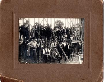
Photograph, Watson's Photos, Belgrave, Building Austral Hall, Belgrave, 1920
Black and White photo on a brown cardboard mount, showing a large group of men (about 30) and children (about 6) in front of and on the wooden frame of the partially constructed Belgrave Catholic Church Hall, Austral Hall, corner of (now) Reynolds Lane & Burwood Highway. The men are dressed in various combinations of hats, ties, shirts, jackets, trousers and work aprons. Some have tool belts or are holding hammers and other tools. Two small girls are seated on their fathers' laps. A man is sitting on his haunches at the front. He is wearing a suit and loose bow tie and holding a hat. He appears to be an official. Another man is patting or holding a dog. The building seems to have two walls partially constructed. There are trees visible in the background which are on the high side of the main road of Belgrave. A moulded brown cardboard mount measures 24.7 X 20.00. On the reverse side is written in pencil, 'Building Church hall/ at/ Belgrave/ Saturday 11th Dec 1920.' There is a stamped business name which reads 'Watson's/ photos/ Belgrave.' The Hall was built by largely volunteer labour as the Austral Hall, financed largely by Harry Luscombe's dances and functions. The land was donated by the Buckley Family. On the reverse side is written in pencil, 'Building Church hall/ at/ Belgrave/ Saturday 11th Dec 1920.' There is a stamped business name which reads 'Watson's/ photos/ Belgrave.' -
 Ballarat Tramway Museum
Slide - 35mm slide/s, Graham Evans, Sept. 1971
White cardboard mount, 35mm slide, from the Association of Railway Enthusiast's film strip titled "Provincial Tramway Film Strip" of Ballarat Tram No. 12 approaching the intersection of Victoria and Main Streets in Bridge St. Has Bridge St. and Town Hall in the background. The film strip notes (Reg. Item 2560), provided the following caption details: "At the east end of Bridge St. narrow and congested extension of Sturt St .- was the junction of the "Mt. PLEASANT" (Midland Highway) and the "VICTORIA St" line (Western Highway. No. 12 approaches the junction, correctly set for the "Mt. PLEASANT" LINE - Sept. '71 (Graham Evans) See image btm2563p.tif for high level scan of image. Stamped on base of slide "11771" and written in ink on top edge "No. 12 Bridge St. Ballarat"tramways, trams, are, film strip, bridge st, tram 12 -
 Ballarat Tramway Museum
Slide - 35mm slide/s, Glen Mills, Nov. 1970
White cardboard mount, 35mm slide, from the Association of Railway Enthusiast's film strip titled "Provincial Tramway Film Strip" of No. 21 or could be 27 taken from the Ballarat (Ballarat East) Fire Station tower. Photo taken Nov. 1970. Has the sign of the AMPOL service station in the foreground. Has destination of Special. Tram at the intersection of Main and Barkly Streets. The film strip notes (Reg. Item 2560), provided the following caption details: "Another 1/2 mile or so saw the "Mt PLEASANT" line turn sharply from the Midland Highway and head towards its terminus in the southern suburbs. - Nov. '70 (Glen Mills)" See image btm2564p.tif for high level scan of image. Stamped on base of slide "11772" and written in ink on top edge "12 Mt Pleasant Line Ballarat"tramways, trams, are, film strip, mt pleasant, barkly st -
 Ballarat Tramway Museum
Photograph - Digital image Set of 10, Tony Smith, 1971
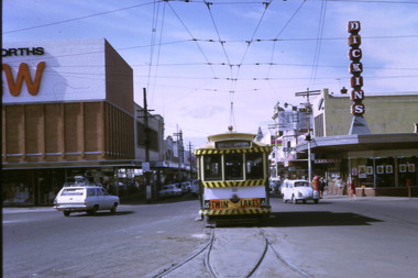
Yields information about Ballarat Tramways and trams prior to the closure of the tramway system.Set of 10 digital images of Ballarat trams prior to closure, scanned from original slides by Tony Smith, 1971 prior to closure of the system. .1 - 33 leaving Bridge St at Grenville St. Tram has destination of Gardens via Sturt St West and a Twin Lakes advert. Has Dickins and Woolworths in the background. .2 - 31 and another single trucker at the Victoria St terminus. Has the widened highway beyond the terminus in the background and Meagher's Hotel. .3 - 21 on the Dawson St cross over (has the destination of Mt Pleasant) with 37 in Sturt St, enroute to Lydiard St Nth. Has St Patrick's Cathedral in the background. .4 - 21 on crossover. .5 - 21 on crossover, waiting for 34 to pass by. .6 - 21 at Stones Corner, Bridge St., has Gear Chemist in the background, along with Bank of NSW. Tram has the destination of Mt Pleasant. .7 - 27 descending the Victoria St hill to Stones Corner, Main St junction. Tram has the destination of Gardens via Drummond St Nth. Has the Viscount ambassador Caravans site in the background. .8 - 21 outbound to Mt Pleasant at the Grant St loop in Barkly St. .9 - 21 and 34 at Grant St loop in Barkly St. .10 - 21 at Mt Pleasant terminus, showing Special. Has a person standing alongside the tram. On the adjacent shop is a "The Sun" sign.trams, tramways, grenville st, sturt st, victoria st, sturt st, dawson st, bridge st, stones corner, mt pleasant, grant st, barkly st, tram 33, tram 31, tram 21, tram 37, tram 34 -
 Ballarat Tramway Museum
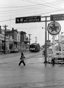
Photograph - Digital image, 1970s
Yields information about the Bakery Hill Victoria St and the Caltex Service Station.Digital image, black and white, of No. 26 descending Bakery Hill to Stone's Corner, Victoria and Main St with the Caltex service station in the foreground. Has a lady with slacks walking across the road and a boy wheeling a bike down the footpath. Note the Highway direction signs and service station signage. O'Brien Motors and a book and record shop on the north side Bakery Hill Victoria St. shops. See Reg 4603 for the subsequent photo at this location. Photo taken by Peter Bruce 1970's and 1971, prior to the closure of the Ballarat tramway system. Peter's Title of image: "No. 26 Bridge and Vic1"trams, tramways, victoria st, main st, stones corner, bakery hill, tram 26 -
 Bayside Gallery - Bayside City Council Art & Heritage Collection
Photograph, Department of Crown Lands and Survey, Victoria, Brighton, Elwood and Elsternwick, c. 1965-71
The Department of Crown Lands and Survey (1857-1983) was responsible for the administration of survey and mapping and the sale, occupation and management of crown land throughout its existence. This aerial photograph shows parts of Brighton, Elwood and Elsternwick and was taken circa 1965-71.brighton, department of crown lands and survey, aerial photograph, bayside, port phillip bay, map, cartographic material, elwood, elsternwick, elsternwick park, elwood tram depot, elwood pier, new street, glen huntly road, st kilda street, nepean highway -
 Bayside Gallery - Bayside City Council Art & Heritage Collection
Photograph, Department of Crown Lands and Survey, Victoria, Brighton, Brighton East and Bentleigh, c. 1965-71
The Department of Crown Lands and Survey (1857-1983) was responsible for the administration of survey and mapping and the sale, occupation and management of crown land throughout its existence. This aerial photograph shows parts of Brighton and Brighton East and was taken circa 1965-71.brighton, department of crown lands and survey, aerial photograph, bayside, port phillip bay, map, cartographic material, brighton east, dendy park, dendy street, centre road, nepean highway, south road, brighton golf course, golf -
 Mrs Aeneas Gunn Memorial Library
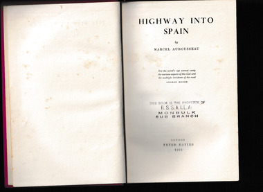
Book, Peter Davies, Highway into Spain, 1930
Accounting of a walking trip from Paris to Andorra.p.294.non-fictionAccounting of a walking trip from Paris to Andorra.france - description and travel, spain - description and travel -
 Mrs Aeneas Gunn Memorial Library
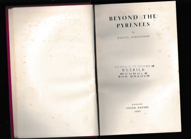
Book, Peter Davies, Beyond the Pyrenees, 1931
First published in one volume under the title of "Highway into Spain". Now published in two volumes, the first part being called "Highway into Spain", this volume being the second part.p.686.non-fictionFirst published in one volume under the title of "Highway into Spain". Now published in two volumes, the first part being called "Highway into Spain", this volume being the second part.france - description and travel, spain - description and travel -
Victorian Harness Racing Heritage Collection at Lord's Raceway Bendigo
Document - Record, Harness Horse, Main Derby
Stephen Spark compiled horses performance records starting in 1983 on his typewriter. Main Derby raced from 1937 (4yo) through to 1945 (12yo). Had a winning streak of 5 wins. Career: 23 wins 11 seconds 10 thirds 90 starts.Typed document in black and red ink.harness racing, australasian harness racing, horse career, performance records, bendigo harness racing club, bhrc, main derby, aw butcher, alf butcher, tom allen, t allen -
 City of Kingston
Book - Minute book, Minute book, Cheltenham Community Hospital, 1938
The Mordialloc-Cheltenham Community Hospital was a hospital in the suburb of Parkdale. Residents of Mordialloc and Chelsea worked towards a community hospital from the late 1930s. Having a community hospital meant residents who required routine surgery did not need to travel into Melbourne to the larger established hospitals. This was important at a time when few people had their own transport. For many years the Mordialloc Carnival Committee contributed to the cost of building the hospital, with one of its contributions to the ‘opening day’ appeal amounting to one thousand pounds, adding to the several thousand already committed. Construction work commenced on the Mordialloc-Cheltenham Community Hospital in 1950. on a site between Booth St and Carrier Ave on the Nepean Highway in Parkdale. The hospital opened in 1953 and serviced the community until 1996. On 1 August 1995, the hospital became a part of the Southern Health Care Network. The former hospital site is now the main location of Central Bayside Community Health Services.Black hard cover book with red spine. cheltenham, mordialloc, hospital, parkdale, health -
 Ringwood and District Historical Society
Photograph, Maroondah Highway Central, Ringwood. Looking west from Warrandyte Road, 1910
Black and white photograph (2 copies)Written on rear of backing sheet of one photograph: "Main Road, Ringwood, looking west, Warrandyte Road coming in from right.". Image of central Ringwood including the E.S.& A. bank, Ringwood's first bank, 1910. -
 Ringwood and District Historical Society
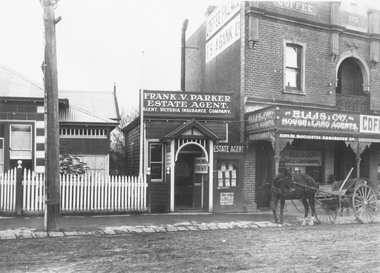
Photograph, Maroondah Highway Central, Ringwood. Second Post Office, c1921
Black and white photograph (2 copies)Written on rear of one backing sheet: "Main Street, Ringwood, second post office, Frank Parker Estate Agent ( later Mayor) and Ellis agent". -
 Ringwood and District Historical Society
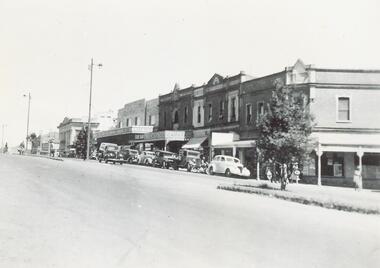
Photograph, Maroondah Highway Central, Ringwood. Corner of Main and Adelaide Streets, 1949
Black and white photograph (2 copies- 1 large, 1 small)Written on backing sheet: "Corner of Main and Adelaide St. 1949". Image shows shops between Adelaide Street and Melbourne Street. -
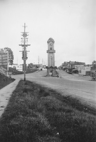 Ringwood and District Historical Society
Photograph, Maroondah Highway Central, Ringwood. Clocktower at intersection of Warrandyte Road and Main Street, 1950
Black and white photograph (2 copies- 1 large, 1 small)Typed under large copy: "Maroondah Highway showing cnr Warrandyte Rd, clocktower at old position. Old Station Masters residence, and shops on right which are now demolished for Safeway store." -
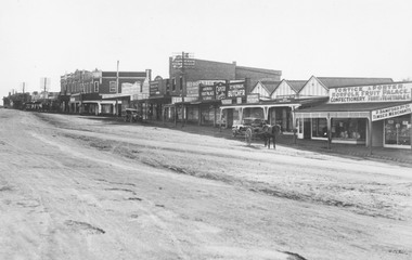 Ringwood and District Historical Society
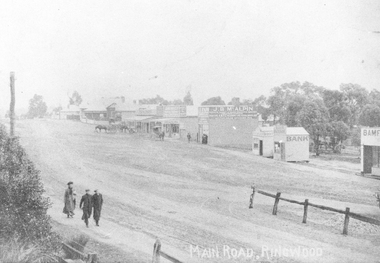
Photograph, Maroondah Highway Central, Ringwood. Shops in Main Street, 1926
Black and white photograph (2 copies) Typed below photograph: "Maroondah Hwy. 1926. Shops now Safeway and Eastland carparks". Written on rear of backing sheet: "Main St. 1926". Image shows unmade street lined with shops from Warrandyte Road to Melbourne Street.