Showing 2403 items
matching maps of goldfields
-
 Bendigo Military Museum
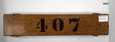
Instrument - Ruler Parallel Rolling 15" with box, Department of Defence Australia, 1944
Used by Army Survey Units to quickly draw parallel lines for map production since 1944.A Brass 2.5" (6.5cm) wide Ruler 15" (38cm) long with brass rollers. Ruler is enclosed in a wooden protective boxRuler engraved with " A.L. FRANKLIN SYDNEY No 514 1944 D^D", Box labeled 407royal australian survey corps, rasvy, fortuna, army survey regiment, army svy regt, asr -
 Bendigo Military Museum
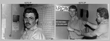
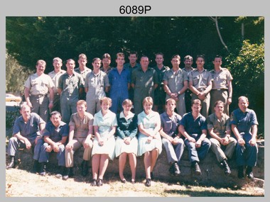
Photograph - Photo Troop, Lithographic Squadron – Army Survey Regiment, Fortuna, Bendigo, c1983
This collection of seven photos was most likely taken at Lithographic Squadron, Army Survey Regiment, Fortuna, Bendigo in c1983. The main tasks undertaken by technicians in Photo Troop were most likely enlargements, reductions and duplication of map reproduction material, and processing of aerial photography.This is a set of seven photographs of Photo Troop personnel and equipment from Lithographic Squadron at the Army Survey Regiment, Fortuna, Bendigo, c1983. The photographs were on 35mm negative film and were scanned at 96 dpi. They are part of the Army Survey Regiment’s Collection. .1) - Photo, black & white, c1983, Photo Troop work area, SGT Garran Hill. .2) - Photo, black & white, c1983, Photo Troop work area, L to R: SPR Steve Burke, SGT Garran Hill. .3) - Photo, black & white, c1983, Photo Troop work area, SPR Steve Burke. .4) - Photo, black & white, c1983, Photo Troop work area, WO1 Noel ‘Nesty’ Coulthard. .5) - Photo, black & white, c1983, Photo Troop work area, WO1 Noel ‘Nesty’ Coulthard. .6) - Photo, black & white, c1983, Photo Troop work area, CPL Gary Tremain. .7) - Photo, black & white, c1983, Photo Troop work area, CPL Neville Carr. No personnel are identified.royal australian survey corps, rasvy, army survey regiment, army svy regt, fortuna, asr, litho -
 Bendigo Military Museum
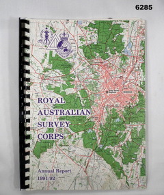
Administrative record - Royal Australian Survey Corps - Annual Report 1991 - 1992, Army Survey Regiment, 30 June 1992
This is a report on the status of Royal Australian Survey Corps mapping and charting and geodesy for the period 1 July 1991 to 30 June 1992A4 Report, Part of Bendigo 1:100,000 map on the cover, Plastic ring binder., gloss paper pages, plastic folders inside back cover containing Indexes of Mapping production and a momento of 50th Anniversary Army Survey Regiment ParadeSigned by Simon Lemon, Director of the Royal Australian Survey Corps - Armyroyal australian survey corps, rasvy, fortuna, army survey regiment, army svy regt, asr -
 Bendigo Military Museum
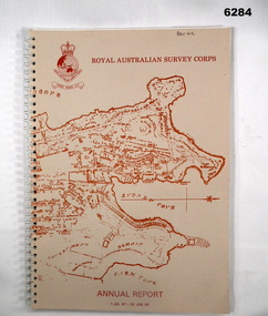
Booklet - Royal Australian Survey Corps - Annual Report 1 Jul 87 - 30 Jun 88, Director of Military Survey -Army, 01.09.1988
Royal Australian Survey Corps Annual Report detailing Surveying and mapping activities 1 July 87 - 30 Jun 88. The first part of the report details the highlights during the period followed by Annexes A to J detailing Australian Map and Chart production. Annex A: 45 pages, Annex B: 1 page Aust Doppler Satelite Stations, Annex C: 1 page, Aust airborne Profile Recording, Annex D: 1 page Aust Aerial photography, Annex E: 1 page Aust Analytical Aerotriangulation, Annex F: 1 page Inertial Positioning System Network Traverses Fils Svy, Annex G: 1 page Global Positioning System Station/networks TI4100 Svy, Annex H: 1 page, Defence Cooperation Programme, Annex I 3 Pages RASvy Officer Manning, Annex J: 1 page RASvy ARES Manning Levels.Buff coloured light cardboard covers. Old map of Sydney Cove area printed in red/brown on front cover and Survey Corps Badge in red top left corner. "Map of the town of Sydney 1836" printed on back cover. A4 sized paper pages, 17 numbered pages plus, Annex A: 45 x pages, Annex B: 1 x page Aust Doppler Satellite Stations, Annex C: 1 x page, Aust Airborne Profile Recording, Annex D: 1 x page Aust Aerial photography, Annex E: 1 x page Aust Analytical Aerotriangulation, Annex F: 1 x page Inertial Positioning System Network Traverses Fils Svy, Annex G: 1 x page Global Positioning System Station/Networks TI4100 Svy, Annex H: 1 x page, Defence Cooperation Programme, Annex I 3 x pages RASvy Officer Manning, Annex J: 1 x page RASvy ARES Manning Levels.royal australian survey corps, rasvy, fortuna, army survey regiment, army svy regt, asr -
 Bendigo Military Museum
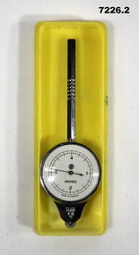
Equipment - MAP MEASURER/OPISMETER, DEPOSE
Vintage opisometer used for measuring distances on maps. Part of the Kevin John Herdman, No. 397661, Collection. See Catalogue No. 5942P for details of his service record..1) Circular chromed metal instrument with handle. Calibrated dial with black markings and hand on a white background. Reverse face has unit conversion details in black text on white background. Each face is covered with a convex glass lens. On the opposite end to the handle is a small wheel with milled edge. As it turns, the hand on the front dial turns to measure distance. .2) Rigid plastic rectangular storage case in two parts. Base is yellow, top is clear..1) Printed on front dial: 'INCHES, MADE IN FRANCE'. Printed on back dial: 'Unit conversion details'. Stamped on metal near wheel: 'DEPOSE, H(logo)B'. .2) Stamped on clear cover: 'CURVIMETRE, MAP MEASURER, H(logo)B, MADE IN FRANCE'.map, map measure, equipment, opisometer, kevin john herdman -
 Bendigo Military Museum
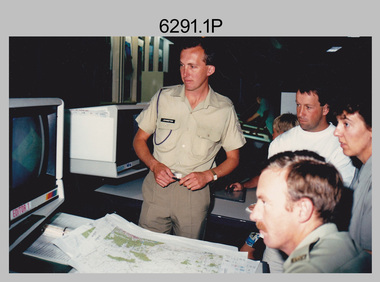
Photograph - Army Survey Regiment Open Day at Fortuna, Bendigo, 1990
These six photographs were taken at an Army Survey Regiment Open Day at Fortuna Villa, Bendigo on the 24th of February 1990. This occasion was one of several events held to commemorate the 75th anniversary of the formation of the Royal Australian Survey Corps. Although historical tours of Fortuna occurred on a regular basis, this was the first technical open day since 1972. The Royal Australian Survey Corps recognised that an Open Day was the best way for the local community in Bendigo to gain an insight into the unit’s important role as Defence’s map production agency, its technical equipment, and its economic importance to Bendigo. It also gave them an opportunity to tour through historic Fortuna Villa. This occasion is covered in more detail in page 143 of Valerie Lovejoy’s book 'Mapmakers of Fortuna – A history of the Army Survey Regiment’ ISBN: 0-646-42120-4. Refer to Item 6247.30P for more photos of the Open Day. These six photographs were taken at an Army Survey Regiment Open Day at Fortuna, Bendigo on the 24th of February 1990. The colour and black & white photographs were printed on photographic paper and are part of the Army Survey Regiment’s Collection. The photographs were scanned at 300 dpi. .1) - Photo, colour, 1990, AUTOMAP 2 L to R: SSGT Graham Johnston, SPR Grant Davis, civilian visitors. .2) - Photo, black & white, 1990. Photo Troop, WO2 Keith Fenton RE. UK Exchange. .3) - Photo, black & white, 1990. Aerotrig, SGT Bruce Hammond, civilian visitors. .4) - Photo, black & white, 1990. AUTOMAP 2 L to R: SPR Peter Smyth, LT Steve Hledik, SGT Martin Evans, MAJ Neil Taylor, Civilian visitors. .5) - black & white, Orthophoto Mapping, L to R: civilian visitors, SSGT Peter Imeson, civilian visitor, SGT Bob Garritty. .6) - black & white, Print Troop L to R: civilian visitors, SSGT Ian Nichols, CPL John ‘Flash’ Anderson..1P to .6P – there are no annotations.royal australian survey corps, army svy regt, rasvy, army survey regiment, fortuna, asr -
 Bendigo Military Museum
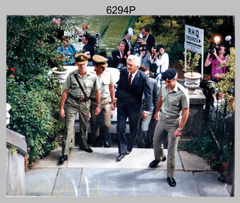
Photograph - Prime Minister’s Visit to the Army Survey Regiment, Fortuna, Bendigo, 1990
This photograph of Prime Minister Hon RJ Hawke’s visit to the Army Survey Regiment was taken at Fortuna, Bendigo in March 1990. This occasion was one of several events held to commemorate the 75th anniversary of the formation of the Royal Australian Survey Corps. The one-hour visit was a rare opportunity for RA Svy to demonstrate to its Prime Minister the unit’s important role as Defence’s map production agency, its technical equipment, and its economic importance to Bendigo. It was also an opportunity to take him through historic Fortuna Villa. This occasion is covered in more detail in page 143 of Valerie Lovejoy’s book 'Mapmakers of Fortuna – A history of the Army Survey Regiment’ ISBN: 0-646-42120-4. Refer to Item 6247.30P for more photos of the Open Day. This photograph of Prime Minister Hon RJ Hawke’s visit to the Army Survey Regiment was taken at Fortuna, Bendigo in March 1990. The colour photograph was printed on photographic paper and is part of the Army Survey Regiment’s Collection. The photograph was scanned at 300 dpi. .1) - Photo, colour, 1990, Prime Minister Hon. R.J. Hawke AC GCL entering the front steps of Fortuna Villa. L to R: unidentified officer, MAJ Duncan Burns, Bob Hawke, John Brumby AO (partially obscured), CO LTCOL Rene van den Tol.There are no annotations.royal australian survey corps, rasvy, army survey regiment, army svy regt, fortuna, asr -
 Bendigo Military Museum
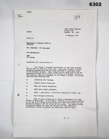
Letter - Army Survey Regiment - Letter of request for additional computer disk space for Automap 2, Army Survey Regiment, 19 Feb 1987
Automap 2 was the Army Survey Regiment's computerized Mapping system. This letter is a request for an additional 700 Mb of computer disk space for the Automap 2 System because of newly developed applications. Those applications were: Analytical Hill shading, Digital Terrain Modelling, Mask and stipple Production, RAAF Chart symbol Placement, ASTIS - Army Survey - Topographic Information System, and, Map Catalog Production.Two page letter, foolscap size, Stapled top left corner"A Spurling, Computer Operations Manager for CO"royal australian survey corps, rasvy, fortuna, army survey regiment, army svy regt, asr -
 Bendigo Military Museum
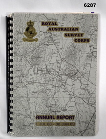
Administrative record - Royal Australian Survey Corps Report on Activities - 1 July 1988 - 30 Jun 1989, Army Survey Regiment, 30 Jun 1989
This is a Report summarizing the activities of the Royal Australian Survey Corps during the F/Y 1988/89A4 Booklet, plastic ring binding with part of 1:250,000 map of SI5-15 Canberra printed on the front cover. Includes text, photos, maps and diagramsroyal australian survey corps, rasvy, fortuna, army survey regiment, army svy regt, asr -
 Warrnambool and District Historical Society Inc.
Document, Map: Lady Bay 1853, 1853
This is one of the earliest surveys and maps of Warrnambool harbor, Lady Bay. Being done in 1853, it shows the depths of the bay area marked in fathoms, currents and directions and areas of rocks around mouth of the Merri and the Western side of the bay as well as a large sand spit to the middle right of the beach region.. It also marks the large areas of seaweed and fuci in the outer bay area. It has the area of Pertobe Lagoon marked and shows the early tracks to the town. The engraving work was done by Tulloch and Brown, with Tulloch being one of the earliest engravers and lithographers in the state of Victoria. He arrived in Melbourne in 1849 and set up business with James Davie Brown in 1853 with Brown being a map engraver. They were awarded bronze and silver medals for their work at the Victorian Industrial Exhibition. He also worked in the vignettes on the Proeschel Map of Victoria.This map is of high historical and comparitive significance as it shows the Lady Bay area prior to the changes that have occurred in the last 160 years with the building of the breakwater. The issue regarding access to Lady Bay remains a current one. The engraver D Tulloch engraved some of the earliest scenes of the goldfields in Ballarat and as such has left a record of a very early and important era in Australian history. Rectangular cream paper with black text. Map area is outlined by fine black lined border. Key in top right hand corner and scale at bottom middle of map.Map is labelled Town of Warrnambool printed at top of map. Small logo at top right corner which has “Hydrographic Department” in circle around an anchor. Lady Bay Warrnambool Surveyed by John Barrow assistant surveyor Engraved by Tulloch & Brown in bottom right corner. Melbourne engraved by order of the legislative Council of Victoria in middle bottom.map, warrnambool, town of warrnambool map 1853, tulloch & brown map 1853, lady bay warrnambool,, warrnambool harbour, warrnambool breakwater, warrnambool beach -
 Eltham District Historical Society Inc
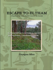
Book, Georgina Allen, Escape to Eltham: A report on the Lanes who left Limerick for Australia, 2013
ESCAPE TO ELTHAM traces the family of John and Anna Lane who lived in Shanagolden in County Limerick during the early and middle parts of the 1800s. They lived during a time of conflict and famine. This story follows the movements of their son, Richard, and daughter, Anne, who migrated to Australia. The marriage of Anne to Tobias Butler and Richard's life establishing his farm on the Yarra River in the 1850s are explored. Marriage, children, deaths and a murder in 1861 are changes forced on the family. Richard's son, Patrick, marries a young Bridget Carrucan but when the global recession of the 1890s decimates Patrick's businesses he heads to the arid Western Australian goldfields to 'make his fortune'. The large family follows and settles in Boulder where the behaviour of a couple of the boys gets them into scapes with the law. This story celebrates the tenacity of a family whose members left adversity in Ireland hoping for a kinder life in Australia.john lane, anna lane, richard lane, patrick lane, bridget carrucan -
 Eltham District Historical Society Inc
Folder, Victorian Goldfields Project: Historic gold mining sites in St Andrews mining division, 1999
... andrews, warrandyte goldfield 35 page report with map and print ...Heritage site report and gazetteer by David Bannear, head consultant for archealogy for the Department of Natural Resources and Environment. Includes information on the Warrandyte Goldfield and the Caledonia Goldfield, Queenstown (now known as St Andrews), One Tree Hill, Kingston (now known as Panton Hill), Kangaroo Grounds, You You Hill, Kingstown, South Morang, Nillumbik, (now known as Diamond Creek), Steele's Creek, Yarrambet and Kinglake. Photocopy of map headed: Location of mines and reefs from Geological survey of Victoria, Yan Yean with the Diamond Creek prominant on the map. no date35 page report with map and print out of cover letter (email form) from donorcaledonian gold fields, caledonina gold field, david bannear, gold mining, harry gilham collection, queenstown, st andrews, warrandyte goldfield -
 Marysville & District Historical Society
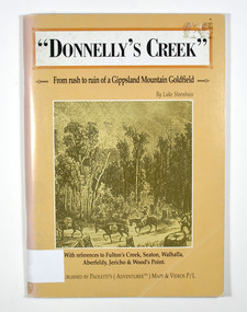
Book - Paperback book, Donnelly's Creek-From rush to ruin of a Gippsland Mountain Goldfield, 1990
A history of the Donnelly's Creek gold mine in VictoriaPaperback. Front cover has a drawing depicting two horses carrying packs followed by a man mounted on a horse. There is also two men on foot following with packs and walking poles. They are walking along a forest track that has some tree stumps alongside it.The back cover has two colour photographs. The top one is of an old wooden building with what appears to be an attached lean to. Both of the buildings have stone chimneys. There is a group of people sitting and standing outside the main building. The bottom photograph appears to be the ruins of a building and a fence. There are three people viewing the ruins.The captions accompanying the photographs are: History revisited - O'Sullivans Old Toombon Hotel Recreated and Remnants of a Bygone Mining Era.Stamp of the Marysville & District Historical Society Inc / P O Box 22 / Marysville 3779gold, gold miner, gold mining, gold field, gippsland, victoria, australia, history, fulton's creek, seaton, walhalla, aberfeldy, jericho, wood's point -
 Marysville & District Historical Society
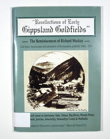
Book - Paperback book, Recollections of Early Gippsland Goldfields-The Reminiscences of Richard Mackay, 2000
Recollections by Richard Mackay of the early history of the Gippsland goldfieldsPaperback. Cover is green. Front cover has a sepia photograph of a drawing with the caption 'Walhalla in its heyday. Back cover has a photograph of an old building with a sign on it that says 'Copper Mine Hotel'. There is a man standing in front of the building. In the foreground is a four wheel drive vehicle.Stamp of the Marysville & District Historical Society Inc / P.O. Box 22 / Marysville 3779gold, gold fields, gold miner, gold mining, gold town, gippsland, victoria, australia, history, jamieson, sale, omeo, big river, wood's point, matlock, jericho, aberfeldy, donnelly's creek, walhalla -
 Marysville & District Historical Society
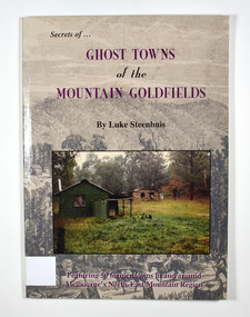
Book - Paperback book, Ghost Towns of the Mountain Goldfields, 1999
Ghost towns of the mountain goldfields in VictoriaPaperback. Cover has a drawing depicting horses, both ridden and pack, walking along a forest track on their way to a small town. There are heavily forested mountains in the distance. Overlaid onto the drawing is a modern photograph of an old stone building. In the foreground is a green timber building with a water tank and verandah. It is all set in the clearing in the middle of a forest.Stamp of the Marysville & District Historical Society Inc / P.O. Box 22 / Marysville 3779 Also the inscription: To Alma / Thanks for your help / Signature / LS / November 1999gold, gold mining, gold town, ghost town, victoria, australia, history -
 Marysville & District Historical Society
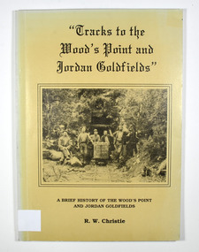
Book, Tracks to the Wood's Point and Jordan Goldfields-A brief history of the Wood's Point and Jordan Goldfields
A history of the Wood's Point and Jordan gold fieldsPaperback. Beige cover. Front cover has a black and white photograph of miners standing and sitting around a mine cart that is sitting on railway tracks at the entrance to a mine.Back cover has a cartoon drawing of a pack horse that has fallen down a cliff with his rider trying to pull him back up by his tail. Inside the cover is a drawn map entitled 'Map of the Mining District round Wood's point'.Stamp of the Marysville & District Historical Society Inc / P.O. Box 22 / Marysville 3779 gold, gold field, gold mining, gold town, wood's point, jordan goldfields, victoria, australia, history, r w christie -
 Marysville & District Historical Society
Book, Tracks to the Wood's Point and Jordan Goldfields-A brief history of the Wood's Point and Jordan Goldfields
A history of the Wood's Point and Jordan gold fieldsPaperback. Beige cover. Front cover has a black and white photograph of miners standing and sitting around a mine cart that is sitting on railway tracks at the entrance to a mine.Back cover has a cartoon drawing of a pack horse that has fallen down a cliff with his rider trying to pull him back up by his tail. Inside the cover is a drawn map entitled 'Map of the Mining District round Wood's point'.Stamp of Marysville & District / Historical Society Inc / P.O. Box 22 / Marysville 3779 gold, gold field, gold mining, gold town, wood's point, jordan goldfields, victoria, australia, history, r w christie -
 Federation University Historical Collection
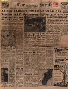
Newspaper, The Herald: Allies Launch Invasion Nea Lae, 1945, 03/09/1945
Broadsheet newspaper from World War Two. world war two, douglas macarthur, lae, new guinea, italy, map, soviet front, luftwaffe, war loan, women volunteers, vegetables -
 Federation University Historical Collection
Document - SMB Documents E.J. Barker, Various School of Mines Ballarat Papers collected by E.J. Barker
E.J. Barker is a past principal of the School of Mines Ballarat and the Library at the Mt Helen Campus is named after him. School of Mines is a predecessor of Federation UniversityLetters, Reports Plans, Ephemera and Clipboard associated with E.J. Barker and the School of Mines Ballaratplanning requirements, individual rooms, dr ron wild, school of mines and industries ballarat, institute profile, location map, university of ballarat, campus plan, great hall/arts complex, notes, 1970-72 building program, operations and decisions, report to council, visit by principal, priorities, electrical engineering, mt helen, minutes of special council meeting, university of melbourne, engineering, mt helen development report, administration building, technical art school, former ballarat gaol, the court house, smb community centre, trust news, articles, discovery day, k.j. flecknoe, retirement, membership of sub committee, n.a crouch, e.j. barker, k.l. cross, w.j. gribble, l.f.j. hillman, r.c lovett, d. nicholson, g. robertson, p.r. shiells, b. tanner, r. feary, i. harris, b.c. mclennan, m. stevens, t.a. wiseman, d.r. bolster, p.h. dixon, r. dunlop, r. furness, e.j. lumsdon, a. mccaffrey, p.r. davies, d. farnsworth, j. harrison, k. mcfarlane, j. mills, s.a. mendelson, i. robinson, d.j. fraser, j. van dreven, k. alsop, b. bridges, m. palmer, r. sutton, l. snibson, h. van hammond, t. runnalls, p. sculley, g. shearer, t. slater, michael ronaldson, robert lovett, edward john barker, e.j. barker building, council membership, clipboard, n.g curry, state college of victoria, articles of association, memorandum, australian conference of principles of colleges of advanced education, commonwealth ministerial working party, victorian post secondary education commission, australian institute of physics symposium, royal australian institute of public administration, premier of victoria, r.j. hamer, m.b. john, new south wales institute of technology, phone messages, peter o'loughlin, annual report, signing of agreement, position description, certificates, fifth form -
 Federation University Historical Collection
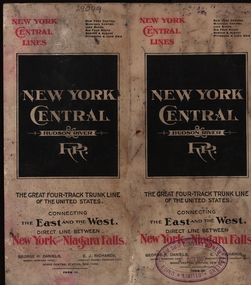
Map, New York Central Hudson River Map and Timetable
Henry Sutton is a talented world-wide accepted inventor with inventions relating to the telephone, photography, wireless, cars, motorcycles, and bicycles as well as many more inventions. Henry was also one of four brothers that ran the Sutton's Music Store after the death of their Father Richard Sutton. Henry Sutton taught Applied Electricity at the Ballarat School of Mines in 1883 to 1886.New York Central Hudson River Map and Timetable with red and black writing used by Henry SuttonUnion Steam Ship Company of New Zealand Limited stamp on the front.henry sutton, union steam ship company of new zealand limited, new york central, hudson river, map -
Federation University Historical Collection
Map - Plan, Ballarat Deep Leads and Mines, 1992, 1992
This is Bulletin No. 62: Deep Lead Gold Deposits in Victoria. Map No.6 Ballarat Sheet 1 of 2 The map shows geology, topography and information on mines in the following areas: one large map of the Ballarat area with five enlargements for: Sago Hill District; Scarsdale District; Pitfield Plains District; Berringa Gold Field and Rokewood District. Ballarat Mines and Deep Leads Report No.94 (Finlay and Douglas,1992) provides a summary of the Geological Survey of Victoria mines database, references and geology for most of the mines on this map. Geology Compilation: simplified from earlier Departmental mapping with minor field checking by E.N.M. Plier-Malone. Very large rectangular sheet of paper with seven coloured maps of various sizes and a small green rectangle on the bottom rhs with a map of Victoria superimposed over a poppet head. this rectangle includes information of the other maps shown. The background for these maps is white. Also includes tables of names of mine companies, name of shafts and gold production.gold mines of australia, gold mines of victoria, gold mines- ballarat and district, gold mines pitfield plains district, gold mines scarsdale district, gold mines berringa gold field, gold mines rokewood district, gold mines sago hill district, map - gold mines, map - gold mines in victoria, ballarat, pitfield, scarsdale, berringa, rokewood, sago hill, deep lead gold deposits in victoria, geological survey - gold deposits in victoria, mining, gold deposits in victoria, gold mines in victoria, rokewook, pitfield plains -
 Bendigo Military Museum
Photograph - Photo Troop, Lithographic Squadron - Army Survey Regiment, Bendigo, 1989
This is a photograph of Photo Troop, Lithographic Squadron; one of the Army Survey Regiment’s four squadrons, at Fortuna, Bendigo, December 1989. The main tasks undertaken by Photo Troop’s technicians were most likely photographic enlargements, reductions and duplication of map reproduction material, and processing of aerial photography.This is a photograph of Photo Troop Lithographic Squadron, Army Survey Regiment at Fortuna, Bendigo, 1989. The colour photograph was printed on photographic paper and is part of the Army Survey Regiment’s Collection. The photograph was scanned at 300 dpi. Back Row L to R: Rob Bogumil, Kevin ‘Chuck’ Berry, Andrew ‘Morrie’ Morrison-Evans, unidentified, Greg Howell, unidentified, Damien Cole, unidentified, Warren ‘Waldo’ Shirley, Steve Burke, Paul Baker, Bob Garritty, Frank Lenane, Bill Jones. Front Row L to R: John Bragg, Ken Peters, Gavin Craggs, Michelle Withers, Penny Knott, Di Chalmers, Geoff Webb, unidentified, Darren ‘Barney’ Maher, Kim Reynolds. No personnel are identified. Annotated on back with ‘Photo Troop Dec 1989’royal australian survey corps, rasvy, army survey regiment, army svy regt, fortuna, asr, litho -
 Bendigo Military Museum
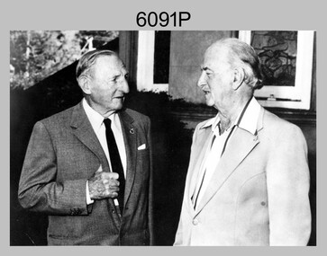
Photograph - Army Survey Regiment – CAPT Jack Cullen (Ret), Fortuna, Bendigo, c1978
This is a photograph of CAPT Jack Cullen (Ret) and an unidentified person besides the front steps of Fortuna Villa, Bendigo, c1978. Jack Cullen served for many years in the Royal Australian Survey Corps from 1920 to 1952, after active service with the AIF in WW1. His service at Fortuna began in 1944 when he was a Lieutenant in charge of a map compilation section. Jack Cullen’s service is covered in more detail with additional historic photographs, in Valerie Lovejoy’s book 'Mapmakers of Fortuna – A history of the Army Survey Regiment’ ISBN: 0-646-42120-4This is a photograph of CAPT Jack Cullen (Ret) and an unidentified person at the Army Survey Regiment, Fortuna, Bendigo, c1978. The photograph was printed on photographic paper and is part of the Army Survey Regiment’s Collection. The photograph was scanned at 300 dpi. Photo, black & white, c1988: L to R: CAPT Jack Cullen (Ret), unidentified person‘Jack Cullen’ is annotated on back of the photoroyal australian survey corps, rasvy, army survey regiment, army svy regt, fortuna, asr -
 Bendigo Military Museum
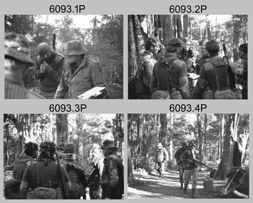
Photograph - Army Survey Regiment - Regimental Training Field Phase, c1988
This is a set of 31 photographs of Army Survey Regiment personnel undertaking regimental training in the Wellsford Forest, Bendigo, c1988. The aim of the training was to provide personnel a practical knowledge of infantry and minor tactics at the section level, navigation and map reading, RATEL and Survival in the Field. This is a set of 31 photographs of the Army Survey Regiment undertaking regimental training in the Wellsford Forest, Bendigo. c1988. The photographs were printed on photographic paper and negatives are on 35mm film. They are part of the Army Survey Regiment’s Collection. The photographs were scanned at 300 dpi and negatives at 96 dpi .1) - Photo, black & white, c1988, unidentified personnel. .2) - Photo, black & white, c1988, CPL Terry ‘TJ’ Wicker 3rd from right. .3) - Photo, black & white, c1988, unidentified personnel. .4) - Photo, black & white, c1988, unidentified personnel. .5) - Photo, black & white, c1988, L to R: CPL Steve Coulson, unidentified. .6) - Photo, black & white, c1988, L to R: SPR Kerron South, unidentified – radio, unidentified personnel, SPR Wally Twidale. .7) - Photo, black & white, c1988, unidentified – radio, .8) - Photo, black & white, c1988, L to R: CPL John Bettridge, SPR Wally Twidale, SPR Shane ‘Soupy’ Campbell. .9) - Photo, black & white, c1988, SPR Kerron South .10) - Photo, black & white, c1988, L to R: unidentified, CPL Terry ‘TJ’ Wicker, unidentified. .11) - Photo, black & white, c1988, unidentified personnel. .12) - Photo, black & white, c1988. .13) - Photo, black & white, c1988. .14) - Photo, black & white, c1988, L to R: unidentified personnel, SPR Kerron South .15) - Photo, black & white, c1988, unidentified, CPL Terry ‘TJ’ Wicker, unidentified. .16) - Photo, black & white, c1988, L to R: unidentified personnel, SPR Jim Ash. .17) - Photo, black & white, c1988, MAJ Rene van den Tol .18) - Photo, black & white, c1988, L to R: WO2 Pat Lumsden, SPR Sue (Foote) Bourne. .20) - Photo, black & white, c1988, vehicles. .21) - Photo, black & white, c1988, tentage. .21) - Photo, black & white, c1988, L to R: MAJ Roger Rix, CAPT Dave Sankey, MAJ Bob Roche, unidentified. .23) - Photo, black & white, c1988, L to R: WO2 Alan Bunn, unidentified. .24) - Photo, black & white, c1988, unidentified personnel. .25) - Photo, black & white, c1988, unidentified personnel. .26) - Photo, black & white, c1988, unidentified personnel. .27) - Photo, black & white, c1988, L to R: unidentified personnel, WO2 Rob Bogumil. .28) - Photo, black & white, c1988, unidentified personnel. .29) - Photo, black & white, c1988, unidentified personnel. .30) - Photo, black & white, c1988, L to R: SPR Sue (Foote) Bourne, SPR Tracy (Parker) Ash. .31) - Photo, black & white, c1988, L to R: SPR Tracy (Parker) Ash, SPR Sue (Foote) Bourne..1P to .31P – No personnel are identifiedroyal australian survey corps, rasvy, army survey regiment, army svy regt, fortuna, asr -
 Bendigo Military Museum
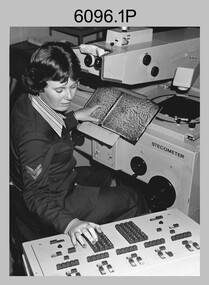
Photograph - Army Survey Regiment – Map Production, Fortuna, Bendigo, c1980s
... goldfields These five photographs of map production and the car park ...These five photographs of map production and the car park area were taken at Fortuna, Bendigo, c1980s. The first three photographs were taken in Air Survey Squadron, where aerotriangulation and digital photogrammetric extraction of topographic features from aerial photography were undertaken. Photo .4P was taken in Cartographic Squadron’s Correcting Section, located in the Attic. The technicians were probably involved in a rapid response map production, as they all were wearing field uniforms. The Army Survey Regiment’s Duty Room, RAP and Carpark appear in Photo .5P. It was probably taken from the top steps near the SGT’s accommodation block in 1986. Photos .4P and .5P are also published with item 6395.17P.This is a set of five photograph of Map Production and car park, at the Army Survey Regiment, Fortuna, Bendigo, c1980s. The photographs were printed on photographic paper and is part of the Army Survey Regiment’s Collection. Photograph .1P was scanned at 200 dpi. The others were scanned at 300 dpi. .1) - Photo, black & white, c1980s: CPL Marrianne (Van De Zee) De Groot measuring aerial photographs with a stecometer. .2) - Photo, colour, c1980s: Two unidentified technicians assessing a flight line diagram. .3) - Photo, black & white, c1980s: SPR Scheryl Delforce digitising map features on an AUTOMAP 1 Graticon table. .4) - Photo, black & white, 1986: L to R: CPL Andy Lucas, SPR Chris Gordon, unidentified, SPR Jan (Crighton) Minchin, SPR Robin Marshall, CPL Frank Downie, SPR Gayle Humphrey, unidentified technicians in the Attic, Fortuna. .5) - Photo, black & white, 1986: Army Survey Regiment Duty Room, RAP and Carpark at Fortuna. .1P - Annotated on back ‘Maryanne Degroot’ .2P, .4P to .5P – no annotation .3P - Annotated on back ‘Scheryl Delforce’royal australian survey corps, rasvy, army survey regiment, army svy regt, fortuna, asr, air survey, carto, aerotrig -
 Bendigo Military Museum
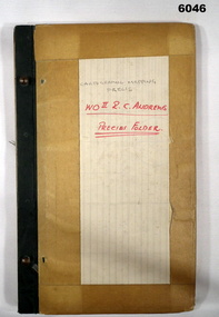
Journal - Cartographic Mapping Precis - WO2 R C Andrews Mapping Precis Folder, Circa 1960
This is a compilation of Precis about cartographic mapping procedures to produce a map, compiled by WOII RC Andrews, Technical Warrant Officer Cartographic Squadron, retired 1975.Book with 2 x "chicago" screws, cardboard cover- brown, green cloth tape along binding edge"WO II R. C. ANDREWS PRECIS FOLDER"royal australian survey corps, rasvy, fortuna, army survey regiment, army svy regt, asr -
 Bendigo Military Museum
Map - EASTER NEW GUINEA NAVIGATION CHART, RAAF, Aug 1943
From the collection of "Maxwell Lennox Matheson" No.418447 RAAF. Enlisted 22/5/1942 Aged 19. Discharged 19/2/1948 - Rank FLTLT.This map is in colour. It is made of a stiff paper and has a map printed on both sides. Side1 - scale 1:2,315,000. 31.72 Nautical miles = 1 inch. It shows Eastern half of New Guinea. It also shows New Britain and New Ireland. Manus Island is at the top. Side 2 - Scale 1:1,000,000 - this shows Manus Island on right side, top of New Guinea at bottom edge (Wewak) and some other little islands. The map on side 1 has numerous navigation tracks and calculations in pencil. i.e. LAE, KOKODA, PORT MORESBY.ww2, raaf, new guinea -
 Bendigo Military Museum
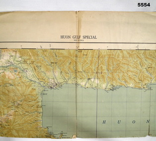
Map - AERONAUTICAL MAP of LAE AREA, RAAF et al, Aug 1944
Refer to Cat 5547 for Matheson.This map is on heavy paper. it is coloured and on one side only. Scale 1:1,000,000. The top centre is the Ramu Valley. Right side is Finchafen, bottom town is south of Salamaw.It shows in pencil where ...were dropped at Nadzab. the enemy track heading NW up to Dumpu. Then movements around Astrolab Bayww2, new guinea, map -
 Bendigo Military Museum
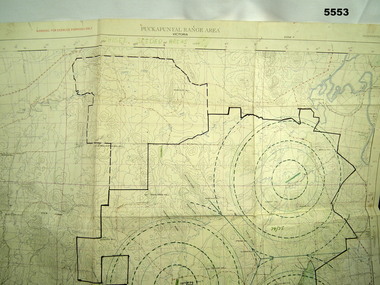
Map - MAP of PUCKAPUNYAL, RAAF et al, 1958
Refer to Cat 5547, Matheson.This is a large map, printed in colour on one side only. Scale 1:25,999. The grid squares are 1000 x 1000 metres. it shows the camp, ranges and bush areas used by the military.This map is covered in a large number of added colour shadings, nav lines, airstrips and circles.puckapunyal army base, military training, map -
 Bendigo Military Museum
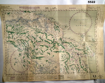
Map - MAP, HUON GULF AREA, Aust Survey Corps et al, Aug 43
Refer Cat 5547 - Matheson.This is a single sided map, printed in colour. Scale 1:253,440, 4 miles to an inch, grid squares are 10mm x 10mm. Top right side shows Finschafen. Top centre is Lae, Middle is Salamau. Bottom is Lasanga Island. Top left vicinity is Nadzab and Markham River.There are four "corner" marks in pencil. Two on land and two out in the gulf.ww2, new guinea, map