Showing 331 items
matching maritime navigation
-
 Flagstaff Hill Maritime Museum and Village
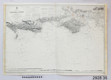
Document - Navigation Chart, Portland to Owers
... Flagstaff Hill Maritime Museum and Village 89 Merri Street ...British Admiralty Navigation Chart - Portland to Owers, England - South Coastwarrnambool, shipwrecked-coast, flagstaff-hill, flagstaff-hill-maritime-museum, maritime-museum, shipwreck-coast, flagstaff-hill-maritime-village, shipwrecked-artefact, navigation chart, british admiralty navigation chart, british admiralty, portland to owers -
 Flagstaff Hill Maritime Museum and Village
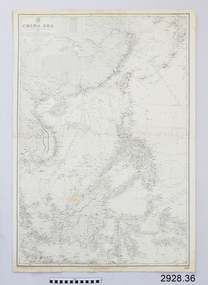
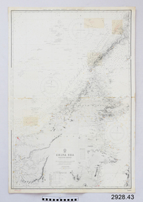
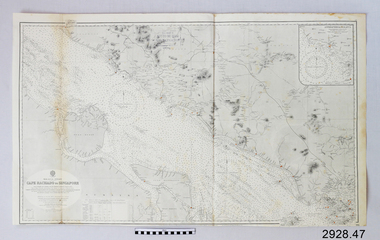
Document - Navigation Chart, China Sea
... Flagstaff Hill Maritime Museum and Village 89 Merri Street ...British Admiralty Navigation Chart - China Seawarrnambool, shipwrecked-coast, flagstaff-hill, flagstaff-hill-maritime-museum, maritime-museum, shipwreck-coast, flagstaff-hill-maritime-village, shipwrecked-artefact, navigation chart, british admiralty navigation chart, british admiralty, china sea -
 Flagstaff Hill Maritime Museum and Village
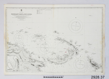
Document - Navigation Chart, North-East Coast of New Guinea
... Flagstaff Hill Maritime Museum and Village 89 Merri Street ...British Admiralty Navigation Chart - North-East Coast of New Guinea with Bouganville, New Britian, New Ireland and Admiralty Islandwarrnambool, shipwrecked-coast, flagstaff-hill, flagstaff-hill-maritime-museum, maritime-museum, shipwreck-coast, flagstaff-hill-maritime-village, shipwrecked-artefact, navigation chart, british admiralty navigation chart, british admiralty, new guinea -
 Flagstaff Hill Maritime Museum and Village
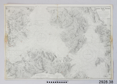
Document - Navigation Chart, Hong Kong, Water East
... Flagstaff Hill Maritime Museum and Village 89 Merri Street ...British Admiralty Navigation Chart - Hong Kong, Water Eastwarrnambool, shipwrecked-coast, flagstaff-hill, flagstaff-hill-maritime-museum, maritime-museum, shipwreck-coast, flagstaff-hill-maritime-village, shipwrecked-artefact, navigation chart, british admiralty navigation chart, british admiralty, hong kong -
 Flagstaff Hill Maritime Museum and Village
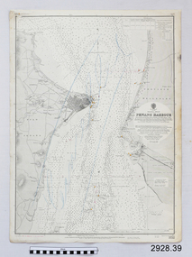
Document - Navigation Chart, Penang Harbour
... Flagstaff Hill Maritime Museum and Village 89 Merri Street ...British Admiralty Navigation Chart - Penang Harbour and Malacca Straitswarrnambool, shipwrecked-coast, flagstaff-hill, flagstaff-hill-maritime-museum, maritime-museum, shipwreck-coast, flagstaff-hill-maritime-village, shipwrecked-artefact, navigation chart, british admiralty navigation chart, british admiralty, penang harbour -
 Flagstaff Hill Maritime Museum and Village
Document - Navigation Chart, Approaches to Yangtze Kiang
... Flagstaff Hill Maritime Museum and Village 89 Merri Street ...British Admiralty Navigation Chart - Approaches to Yangtze Kiangwarrnambool, shipwrecked-coast, flagstaff-hill, flagstaff-hill-maritime-museum, maritime-museum, shipwreck-coast, flagstaff-hill-maritime-village, shipwrecked-artefact, navigation chart, british admiralty navigation chart, british admiralty, yangtze kiang -
 Flagstaff Hill Maritime Museum and Village
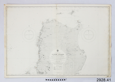
Document - Navigation Chart, Luzon Island : North of Latitude 16º 20' North
... Flagstaff Hill Maritime Museum and Village 89 Merri Street ...British Admiralty Navigation Chart - Luzon Island : North of Latitude 16º 20' Northwarrnambool, shipwrecked-coast, flagstaff-hill, flagstaff-hill-maritime-museum, maritime-museum, shipwreck-coast, flagstaff-hill-maritime-village, shipwrecked-artefact, navigation chart, british admiralty navigation chart, british admiralty, luzon island -
 Flagstaff Hill Maritime Museum and Village
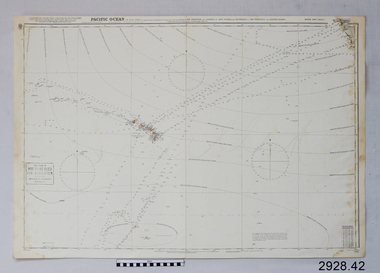
Document - Navigation Chart, Pacific Ocean
... Flagstaff Hill Maritime Museum and Village 89 Merri Street ...British Admiralty Navigation Chart - Pacific Ocean, North East Sheetwarrnambool, shipwrecked-coast, flagstaff-hill, flagstaff-hill-maritime-museum, maritime-museum, shipwreck-coast, flagstaff-hill-maritime-village, shipwrecked-artefact, navigation chart, british admiralty navigation chart, british admiralty, pacific ocean -
 Flagstaff Hill Maritime Museum and Village
Document - Navigation Chart, China Sea
... Flagstaff Hill Maritime Museum and Village 89 Merri Street ...British Admiralty Navigation Chart - China Sea, Southern Portion - Eastern Sheetwarrnambool, shipwrecked-coast, flagstaff-hill, flagstaff-hill-maritime-museum, maritime-museum, shipwreck-coast, flagstaff-hill-maritime-village, shipwrecked-artefact, navigation chart, british admiralty navigation chart, british admiralty, china sea -
 Flagstaff Hill Maritime Museum and Village
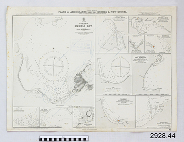
Document - Navigation Chart, Plan of Anchorages between Borneo and New Guinea
... Flagstaff Hill Maritime Museum and Village 89 Merri Street ...British Admiralty Navigation Chart - Plan of Anchorages between Borneo and New Guinea with Kayeli Baywarrnambool, shipwrecked-coast, flagstaff-hill, flagstaff-hill-maritime-museum, maritime-museum, shipwreck-coast, flagstaff-hill-maritime-village, shipwrecked-artefact, navigation chart, british admiralty navigation chart, british admiralty -
 Flagstaff Hill Maritime Museum and Village
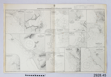
Document - Navigation Chart, Harbours and Anchorages in the Hawaiian Islands or Sandwich Islands
... Flagstaff Hill Maritime Museum and Village 89 Merri Street ...British Admiralty Navigation Chart - Harbours and Anchorages in the Hawaiian Islands or Sandwich Islandswarrnambool, shipwrecked-coast, flagstaff-hill, flagstaff-hill-maritime-museum, maritime-museum, shipwreck-coast, flagstaff-hill-maritime-village, shipwrecked-artefact, navigation chart, british admiralty navigation chart, british admiralty, hawaiian islands -
 Flagstaff Hill Maritime Museum and Village
Document - Navigation Chart, Chinnampo Ko, Pingyang Inlet : Yellow Sea, West Coast of Korea
... Flagstaff Hill Maritime Museum and Village 89 Merri Street ...British Admiralty Navigation Chart, Chinnampo Ko, Pingyang Inlet : Yellow Sea, West Coast of Koreawarrnambool, shipwrecked-coast, flagstaff-hill, flagstaff-hill-maritime-museum, maritime-museum, shipwreck-coast, flagstaff-hill-maritime-village, shipwrecked-artefact, navigation chart, british admiralty navigation chart, british admiralty, pingyang inlet, chinnampo ko -
 Flagstaff Hill Maritime Museum and Village
Document - Navigation Chart, Cape Rachado to Singapore
... Flagstaff Hill Maritime Museum and Village 89 Merri Street ...British Admiralty Navigation Chart - Cape Rachado to Singapore - Malacca Straitswarrnambool, shipwrecked-coast, flagstaff-hill, flagstaff-hill-maritime-museum, maritime-museum, shipwreck-coast, flagstaff-hill-maritime-village, shipwrecked-artefact, navigation chart, british admiralty navigation chart, british admiralty -
 Flagstaff Hill Maritime Museum and Village
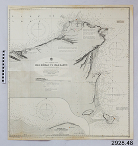
Document - Navigation Chart, Africa - North East Coast - Ras Kòrai to Ras Hafun
... Flagstaff Hill Maritime Museum and Village 89 Merri Street ...British Admiralty Navigation Chart - Africa - North East Coast - Ras Kòrai to Ras Hafunwarrnambool, shipwrecked-coast, flagstaff-hill, flagstaff-hill-maritime-museum, maritime-museum, shipwreck-coast, flagstaff-hill-maritime-village, shipwrecked-artefact, navigation chart, british admiralty navigation chart, british admiralty, ras kòrai to ras hafun -
 Flagstaff Hill Maritime Museum and Village
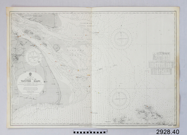
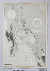
Document - Navigation Chart, Tavoy River
... Flagstaff Hill Maritime Museum and Village 89 Merri Street ...British Admiralty Navigation Chart - Bay of Bexgal - East Coast - Bruma - Tavoy Riverwarrnambool, shipwrecked-coast, flagstaff-hill, flagstaff-hill-maritime-museum, maritime-museum, shipwreck-coast, flagstaff-hill-maritime-village, shipwrecked-artefact, navigation chart, british admiralty navigation chart, british admiralty, tavoy river, bay of bexgal, bruma -
 Flagstaff Hill Maritime Museum and Village
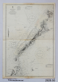
Document - Navigation Chart, Palawan Island
... Flagstaff Hill Maritime Museum and Village 89 Merri Street ...British Admiralty Navigation Chart - China Sea- Palawan Islandwarrnambool, shipwrecked-coast, flagstaff-hill, flagstaff-hill-maritime-museum, maritime-museum, shipwreck-coast, flagstaff-hill-maritime-village, shipwrecked-artefact, navigation chart, british admiralty navigation chart, british admiralty, palawan island -
 Flagstaff Hill Maritime Museum and Village
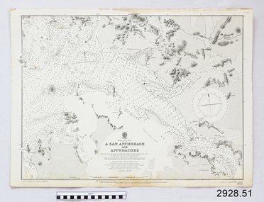
Document - Navigation Chart, A San Anchorage and Approaches
... Flagstaff Hill Maritime Museum and Village 89 Merri Street ...British Admiralty Navigation Chart - Korea - West Coast - A San Anchorage and Approacheswarrnambool, shipwrecked-coast, flagstaff-hill, flagstaff-hill-maritime-museum, maritime-museum, shipwreck-coast, flagstaff-hill-maritime-village, shipwrecked-artefact, navigation chart, british admiralty navigation chart, british admiralty, a san anchorage and approaches -
 Flagstaff Hill Maritime Museum and Village
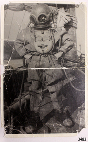
Photograph - Diver, K Tregea, 1900s
This photograph of a deep sea diver on board a vessel is connected to T. Ward. It was possibly part of E.G. Ward's Collection of diving equipment. The photograph was produced in the local town of Timboon. This photograph of an early 1900s diving suit shows part of the history of diving. It is connected to local history through the inscriptions on the back of the photograph; the printer and the name. The south west coast has hundreds of shipwrecks that have been discovered and explored by many divers. Their discoveries have led to us interpreting and understanding more about our history; ship building, exports, immigration, navigation and much more.Black and white photograph, portrait orientation, of a diver dressed in full diving gear standing on board a sailing vessel at sea. Inscriptions on reverse.Handwritten in black pen "T. WARD" Stamped in black ink "REPRODUCED BY" above rectangular stamp. Text within stamp "[K. TREGEA / CALLOWAY ST / TIMBOON VIC"flagstaff hill, warrnambool, shipwrecked-coast, flagstaff-hill, flagstaff-hill-maritime-museum, maritime-museum, shipwreck-coast, flagstaff-hill-maritime-village, photograph, diving gear, diving suit, deep sea diving, deep sea diver, diver, south west victoria, diving photograph, t ward, k tregea, timboon, marine technology, life saving -
 Mission to Seafarers Victoria
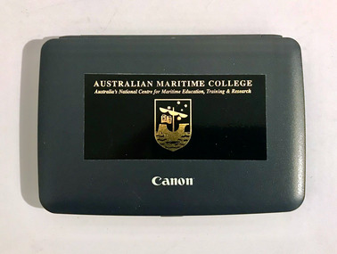
Instrument - Calculator with manual, Canon, ZX 2200, 1990-2000
Small black platic calculator Canon ZX 2200 with sticker from The Australian Maritime College with manual.nautical instrument, navigation instrument, brian mcmahon, ship master -
 Seaworks Maritime Museum
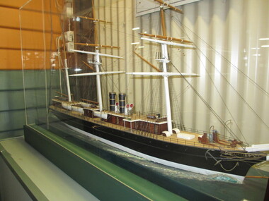
Model ship, SS Iberia, 1873
SS Iberia (1873-1903) was built by John Elder & Co. (Govan yard no.162 Glasgow) and launched 6 December 1873 at a cost £151,600. However, due to strike delays, her maiden voyage was not until 21 October 1874. The Iberia was one of the last of the barque-rigged, clipper-bow type of steamer built for the Pacific Steam Navigation Company. At the time, she was also the second largest ship in world, after the Great Eastern. In 1877, a joint Orient Line and Pacific Steam Navigation Co. venture began a fortnightly mail service, first sailing between England and Australia on 12 May 1880, via Gibraltar, Naples, Port Said, Ismalia, Suez, Colombo, Albany, Adelaide, Melbourne, Sydney. Details: - Tonnage: 4,671 g, 2,982 n. - Dimensions: 433ft 6in (132.13m) x 45ft (13.72m) x 35ft 1in (10.69m). - Powered by a single screw, compound inverted 2 cylinder; 750 NHP; 4,000 IHP engine with steam pressure of 70 lbs, 4 cylindrical boilers, 2 to each funnel. - Speed 14 knots - 1873 Passengers: 100 1st, 150 2nd, 340 3rd Class. - 1893 Passengers: 140 first, 50 second, 800 third Some significant dates in her history include: - 1881: Replaced "Aconcagua" as standby vessel on the London - Suez- Melbourne - Sydney route - 1882: Government transport during the Egyptian Arabi Pasha Campaigns - 1883 Jan 25: Placed on regular service to Australia - 1890 Jun 11: Reverted to the Liverpool - Valparaiso route - 1893: Iberia sailed to Australia to replace a disabled ship. The journey via the Cape was non-stop at 14 knots in 32 days - 1893- Fitted with triple expansion engine; 3 cylinders, 600 NHP; 4 cylindrical boilers; 13 knots; fitted by J.Rollo & Sons, Liverpool - 1903: Broken up at Genoa. 1873 single screw, compound inverted, 2 cylinder; 750 NHP, 4000 IHP, Steam pressure 70 lbs, 4 cylindrical boilers, 2 to each funnel, 14 knots. Second largest ship in the world in 1874 (after the Great Eastern). Cost 151, 600 pounds. 1893 Triple expansion engine fitted. 3 cylinders 600 NHP, 4 cylindrical boilers, 15 knots, fitted by D Rollo and Sons, LiverpoolThe body of the model is carved and molded wood painted in black and white, the planked deck with detailed fittings and rigging, raised on a wooden base with simulated waves. At this time yards removed. "Iberia" -
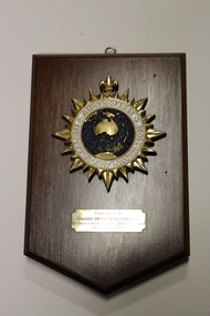 Seaworks Maritime Museum
Plaque, Another Hamilton Design
One varnished teak board plaque from the Australian Institute of Navigation with a metal enamelled emblem of AustraliaPresented to Howard Smith Industries P/L in appreciation of your continuing support December 1995 Australian Institute of Navigation Another Hamilton Design the corporate award specialist ph: 026744266 fax: 026744758 -
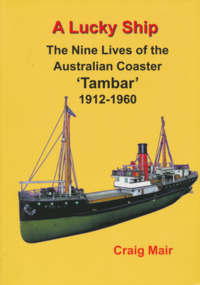 Mission to Seafarers Victoria
Book, Nautical Association of Australia Inc, A Lucky Ship – Nine Lives of Australian Coaster Tambar 1912-1960, 2013
This high-quality book is the extraordinary story of an ordinary little ship that had a long and eventful life. Perhaps few Australian coasters have had a more interesting and varied history. Built in Scotland in 1912 for the North Coast Steam Navigation Company, Tambar worked as a lifeline to isolated river and island communities, first in New South Wales, then for the Tasmanian Government and Holymans in Bass Strait (King Island) and as the last steamer serving the Gippsland Lakes. In between she even spent a few years in Papua New Guinea. When World War II broke out, Tambar was commissioned into the RAN as an auxiliary minesweeper, but after the terrible Darwin air raid in 1942 became the first vessel of the newly formed Salvage Board, later assisting in the search for survivors of the Battle of the Coral Sea. Returning to Bass Strait in 1944 for a few more years, she then spent the 1950s on standby as a salvage vessel in Melbourne, working on Merilyn, Terawhiti, E.J. Fairnie, and River Burnett. Craig Mair grew up in Grangemouth, Scotland where Tambar was built, and became interested after inheriting a builder's model from his father. He has consulted thousands of records, including the ship's logs, tracked down witnesses, and assembled over 100 photographs and maps to give a unique insight into Tambar's story, and coastal Australia in the middle decades of the twentieth century, before roads took over the transport task. Besides many colourful stories of shipwrecks and strandings, strange cargoes, salty characters, exotic places, wartime air raids, and salvage jobs, the book includes a definitive account of the worst Second World War 'friendly fire' incident in Australian waters in Moreton Bay in 1942.250 pages, Appendices, Bibliography and Indices, extensively illustratednon-fictionThis high-quality book is the extraordinary story of an ordinary little ship that had a long and eventful life. Perhaps few Australian coasters have had a more interesting and varied history. Built in Scotland in 1912 for the North Coast Steam Navigation Company, Tambar worked as a lifeline to isolated river and island communities, first in New South Wales, then for the Tasmanian Government and Holymans in Bass Strait (King Island) and as the last steamer serving the Gippsland Lakes. In between she even spent a few years in Papua New Guinea. When World War II broke out, Tambar was commissioned into the RAN as an auxiliary minesweeper, but after the terrible Darwin air raid in 1942 became the first vessel of the newly formed Salvage Board, later assisting in the search for survivors of the Battle of the Coral Sea. Returning to Bass Strait in 1944 for a few more years, she then spent the 1950s on standby as a salvage vessel in Melbourne, working on Merilyn, Terawhiti, E.J. Fairnie, and River Burnett. Craig Mair grew up in Grangemouth, Scotland where Tambar was built, and became interested after inheriting a builder's model from his father. He has consulted thousands of records, including the ship's logs, tracked down witnesses, and assembled over 100 photographs and maps to give a unique insight into Tambar's story, and coastal Australia in the middle decades of the twentieth century, before roads took over the transport task. Besides many colourful stories of shipwrecks and strandings, strange cargoes, salty characters, exotic places, wartime air raids, and salvage jobs, the book includes a definitive account of the worst Second World War 'friendly fire' incident in Australian waters in Moreton Bay in 1942.naa, australian national line, interest group, moreton bay, tambar, coaster, ships -
 Glenelg Shire Council Cultural Collection
Functional object - Navigational Light, n.d
... Cliff Street Portland great-ocean-road PPA navigation light ...PPACircular glass dioptric lens on a cylindrical body, alloy, painted grey, hinged access to the base, fastened with a threaded latch. Battery operated, light missingFront: MEMACK MELB.navigation, light, maritime -
Glenelg Shire Council Cultural Collection
Functional object - Lamp, navigational, c. 1983
From 'Tarragal', tug boat, Port of Portland. Port of Portland Authority CollectionStern navigational light. White-painted copper case with hinged lid. Fastened with hinged latch and clasp on a chain. 180 degree dioptric lens. Fitted with incandescent lamp. Folding handle on top. Three mounting lugs around base.Front: MASTHEAD/ Seahorse/ G. B./ 59682/ Back: (no inscriptions)port of portland collection, tarragal tug, maritime -
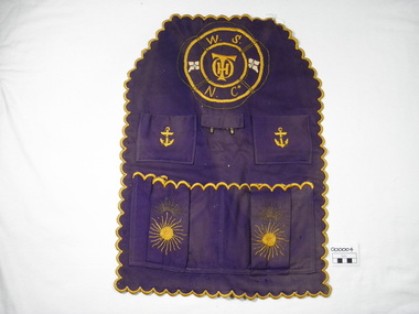 Warrnambool and District Historical Society Inc.
Textile - Work Apron, 1883-1899
The personal 'carry-all', a cloth apron like article was utilised by Thomas Hamilton Osborne in his work with the Warrnambool Steamship Navigation Company. He was Company manager in 1883 until its dissolution in 1899. Osborne wrote many articles on early Warrnambool, particularly maritime material under the name of " Sliding Gunter". When he died he was buried at sea off the breakwater.His sister Mrs Annabella Kell is thought to have made this article.This is a significant item as T.H.Osborne was a key figure in 19th Century Warrnambool history, particularly in maritime affairs. Six sided, scalloped edges, four pockets, two metal hooks, purple woven fabric with yellow and gold embroidery, lifebuoy outline with W.S.N.Co and THO initials embroidered and two flags. Machine sewing of pockets and tab to base apron.W.S.N.Co THO initials on top of each other Two metal hookswork apron, warrnambool steamship navigation company, wsnc, thomas hamilton tracey osborne, annabella kell, sliding gunter -
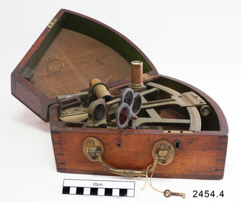
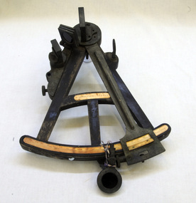 Orbost & District Historical Society
sextant, W. Sutherland
... . sextant maritime navigational An old wooden sextant from the ship ...RIDGE PARK, Length: 65.2 m.; Owned by H. Simpson & Sons; Built at S. P. Austin & Sons in 1878. Registered at Adelaide. On 10 February 1881, RIDGE PARK (Capt. Heslop) was on voyage from Adelaide to Sydney with a cargo of brandy, wine and flour, when she was lost after running aground.Beware Reef is located south east of Cape Conran in east Gippsland. This is the sextant from the Ridge Park which, on10 February 1881, was wrecked on Beware Reef , just south of Cape Conran in east Gippsland. An old wooden sextant from the ship, Ridge Park. It is black with yellow measuring stripes.sextant maritime navigational -
 Flagstaff Hill Maritime Museum and Village
Octant, Mid to late 19th Century
An octant is an astronomical instrument used in measuring the angles of heavenly bodies such as the sun, moon and stars at sea in relation to the horizon. This measurement could then be used to calculate the altitude of the body measured, and then the latitude at sea could also be calculated. The angle of the arms of an octant is 45 degrees, or 1/8 of a circle, which gives the instrument its name. Two men independently developed the octant around 1730: John Hadley (1682–1744), an English mathematician, and Thomas Godfrey (1704–1749), a glazier in Philadelphia. While both have a legitimate and equal claim to the invention, Hadley generally gets the greater share of the credit. This reflects the central role that London and the Royal Society played in the history of scientific instruments in the eighteenth and nineteenth century's. There were also two others who are attributed to having created octanes during this period, Caleb Smith, an English insurance broker with a strong interest in astronomy (in 1734), and Jean-Paul Fouchy, a mathematics professor and astronomer in France (in 1732) In 1767 the first edition of the Nautical Almanac tabulated lunar distances, enabling navigators to find the current time from the angle between the sun and the moon. This angle is sometimes larger than 90°, and thus not possible to measure with an octant. For that reason, Admiral John Campbell, who conducted shipboard experiments with the lunar distance method, suggested a larger instrument and the sextant was developed. From that time onward, the sextant was the instrument that experienced significant development and improvements and was the instrument of choice for naval navigators. The octant continued to be produced well into the 19th century, though it was generally a less accurate and less expensive instrument. The lower price of the octant, including versions without a telescope, made it a practical instrument for ships in the merchant and fishing fleets. One common practice among navigators up to the late nineteenth century was to use both a sextant and an octant. The sextant was used with great care and only for lunar sightings while the octant was used for routine meridional altitude measurements of the sun every day. This protected the very accurate and pricier sextant while using the more affordable octant for general use where it performs well. The invention of the octant was a significant step in providing accuracy of a sailors latitude position at sea and his vessels distance from land when taking sightings of land-based landmarks.Octant with metal handle, three different colored shades are attached, in wooden wedge-shaped box lined with green felt. Key is attached. Two telescope eyepieces are in box. Some parts are missing. Oval ink stamp inside lid of box, scale is graduated to 45 degrees. Ink stamp inside lid of box "SHIPLOVERS SOCIETY OF VICTORIA. LIBRARY"instrument, flagstaff hill, warrnambool, shipwrecked coast, flagstaff hill maritime museum, maritime museum, shipwreck coast, flagstaff hill maritime village, great ocean road, octant, navigation, nautical instrument, navigation instrument, john hadley, sextant, astronomical instrument -
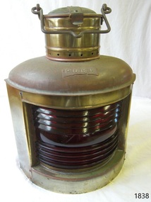 Flagstaff Hill Maritime Museum and Village
Equipment - Kerosene Lamp, Bef. 08-02-1984
The kerosene lamp was one of the most common oil lamps used and was manufactured until the 1980s. This lamp appears to be a modern reproduction of an earlier optional wall-mounted kerosene lamp. The lamp has been produced as an example of a 19th and early 20th-century marine kerosene navigation lamp. Marine lamp; portside metal kerosene lamp with two flat sides, and a curved front. The front has a red ridged glass lens insert and the name "port" is inscribed on a fixed brass plaque. A round chimney is on top of the lid and it has a catch. The fuel tank and wick can be removed through the base. The metal appears to be electroplated.Inscribed on the plaque; "PORT"warrnambool, shipwreck coast, flagstaff hill, flagstaff hill maritime museum, flagstaff hill maritime village, lamp, ship lamp, port lamp, marine lamp, navigation lamp, port, lantern, kerosene lamp, marine technology, ship light, portable lamp -
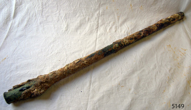 Flagstaff Hill Maritime Museum and Village
Nail
The iron-hulled, four-masted barque, the Falls of Halladale, was a bulk carrier of general cargo. She left New York in August 1908 on her way to Melbourne and Sydney. In her hold, along with 56,763 tiles of unusual beautiful green American slates (roofing tiles), 5,673 coils of barbed wire, 600 stoves, 500 sewing machines, 6500 gallons of oil, 14400 gallons of benzene, and many other manufactured items, were 117 cases of crockery and glassware. Three months later and close to her destination, a navigational error caused the Falls of Halladale to be wrecked on a reef off the Peterborough headland at 3 am on the morning of the 15th of November, 1908. The captain and 29 crew members all survived, but her valuable cargo was largely lost, despite two salvage attempts in 1908-09 and 1910. ABOUT THE ‘FALLS OF HALLADALE’ (1886 - 1908) Built: in1886 by Russell & Co., Greenock shipyards, River Clyde, Scotland, UK. The company was founded in 1870 (or 1873) as a partnership between Joseph Russell (1834-1917), Anderson Rodger and William Todd Lithgow. During the period 1882-92 Russell & Co., standardised designs, which sped up their building process so much that they were able to build 271 ships over that time. In 1886 they introduced a 3000 ton class of sailing vessel with auxiliary engines and brace halyard winches. In 1890 they broke the world output record. Owner: Falls Line, Wright, Breakenridge & Co, 111 Union Street, Glasgow, Scotland. Configuration: Four masted sailing ship; iron-hulled barque; iron masts, wire rigging, fore & aft lifting bridges. Size: Length 83.87m x Breadth 12.6m x Depth 7.23m, Gross tonnage 2085 ton Wrecked: the night of 14th November 1908, Curdies Inlet, Peterborough south west Victoria Crew: 29 The Falls of Halladale was a four-masted sailing ship built-in 1886 in Glasgow, Scotland, for the long-distance cargo trade and was mostly used for Pacific grain trade. She was owned by Wright, Breakenridge & Co of Glasgow and was one of several Falls Line ships, all of which were named after waterfalls in Scotland. The lines flag was of red, blue and white vertical stripes. The Falls of Halladale had a sturdy construction built to carry maximum cargo and able to maintain full sail in heavy gales, one of the last of the ‘windjammers’ that sailed the Trade Route. She and her sister ship, the Falls of Garry, were the first ships in the world to include fore and aft lifting bridges. Previous to this, heavily loaded vessels could have heavy seas break along the full length of the deck, causing serious injury or even death to those on deck. The new, raised catwalk-type decking allowed the crew to move above the deck stormy conditions. This idea is still used today on the most modern tankers and cargo vessels and has proved to be an important step forward in the safety of men at sea. On 4th August 1908, with new sails, 29 crew, and 2800 tons of cargo, the Falls of Halladale left New York, bound for Melbourne and Sydney via the Cape of Good Hope. The cargo on board was valued at £35,000 and included 56,763 tiles of American slate roofing tiles (roof slates), 5,673 coils of barbed wire, 600 stoves, 500 sewing machines, 6,500 gallons of oil, 14,400 gallons of benzene, plumbing iron, 117 cases of crockery and glassware and many other manufactured items. The Falls of Halladale had been at sail for 102 days when, at 3 am on the night of 14th November 1908, under full sail in calm seas with a six knots breeze behind and misleading fog along the coast, the great vessel rose upon an ocean swell and settled on top of a submerged reef near Peterborough on the south-west Victoria’s coast. The ship was jammed on the rocks and began filling with water. The crew launched the two lifeboats and all 29 crew landed safely on the beach over 4 miles away at the Bay of Islands. The postmistress at Peterborough, who kept a watch for vessels in distress, saw the stranding and sent out an alert to the local people. A rescue party went to the aid of the sailors and the Port Campbell rocket crew was dispatched, but the crew had all managed to reach shore safely by the time help arrived. The ship stayed in full sail on the rocky shelf for nearly two months, attracting hundreds of sightseers who watched her slowly disintegrate until the pounding seas and dynamiting by salvagers finally broke her back, and her remains disappeared back into deeper water. The valuable cargo was largely lost, despite two salvage attempts in 1908-09 and 1910. Further salvage operations were made from 1974-1986, during which time 22,000 slate tiles were recovered with the help of 14 oil drums to float them, plus personal artefacts, ship fittings, reams of paper and other items. The Court of Marine Inquiry in Melbourne ruled that the foundering of the ship was entirely due to Captain David Wood Thomson’s navigational error, not too technical failure of the Clyde-built ship. The shipwreck is a popular site for divers, about 300m offshore and in 3 – 15m of water. Some of the original cargo can be seen at the site, including pieces of roof slate and coils of barbed wire. The Falls of Halladale shipwreck is listed on the Victorian Heritage Register (No. S255). She was one of the last ships to sail the Trade Routes. She is one of the first vessels to have fore and aft lifting bridges. She is an example of the remains of an International Cargo Ship and also represents aspects of Victoria’s shipping industry. The wreck is protected as a Historic Shipwreck under the Commonwealth Historic Shipwrecks Act (1976).25½" of round solid copper nail. Recovered from "Falls of Halladale". Ship's nail.flagstaff hill, warrnambool, shipwrecked coast, flagstaff hill maritime museum, maritime museum, shipwreck coast, flagstaff hill maritime village, great ocean road, nail, copper nail, falls of halladale, ship's nail -
 Flagstaff Hill Maritime Museum and Village
Machine - Pulley, Ca 1889
Wooden pulley wheel section from the wreck “Newfield”. The Newfield was a three-masted iron and steel barque, built in Dundee, Scotland, in 1889 by Alexander Stephen and Sons. It was owned by the Newfield Ship Company in 1890 and later that year It was registered in Liverpool to owners Brownells and Co. The Newfield left Sharpness, Scotland, on 28th May 1892 with a crew of 25 under the command of Captain George Scott and on 1st June left Liverpool. She was bound for Brisbane, Australia, with a cargo of 1850 tons of fine rock salt, the main export product of Sharpness. At about 9pm on 28th August 1892, in heavy weather, Captain Scott sighted, between heavy squalls, the Cape Otway light on the mainland of Victoria but, due to a navigational error (the ship’s chronometers were wrong), he assumed it to be the Cape Wickham light on King Island, some 40 miles south. He altered his course to the north, expecting to enter Bass Strait. The ship was now heading straight for the south west Victorian coast and at about 1:30am ran aground on a reef about 100 yards from shore and one mile east of Curdie’s Inlet, Peterborough. The ship struck heavily three times before grounding on an inner shoal with 6 feet of water in the holds. Rough sea made the job of launching lifeboats very difficult. The first two lifeboats launched by the crew were smashed against the side of the ship and some men were crushed or swept away. The third lifeboat brought eight men to shore. It capsized when the crew tried to return it to the ship for further rescue The Port Campbell rocket crew arrived and fired four rocket lines, none of which connected with the ship. A local man, Peter Carmody, volunteered to swim one mile to the ship with a line to guide the fourth and final lifeboat safely to shore. Seventeen men survived the shipwreck but the captain and eight of his crew perished. The Newfield remained upright on the reef with sails set for a considerable time as the wind slowly ripped the canvas to shreds and the sea battered the hull to pieces. The Marine Board inquiry found the wreck was caused by a "one man style of navigation" and that the Captain had not heeded the advice of his crew. According to Jack Loney ‘… when the drama was over . . the Newfield was deserted except for the Captain’s dog and two pigs.’ Flagstaff Hill Maritime Museum has several artefacts that have been salvaged from the wreck. See also other items in the Flagstaff Hill Newfield Collection.The report from SHP documented the following in regards to the Newfield collection: Flagstaff Hill’s collection of artefacts from the Newfield is of historical and archaeological significance at a State level, because of its association with the shipwreck, which is on the Victorian Heritage Register. The collection is significant because of its relationship between the objects. The Newfield collection is archaeologically significant as it is the remains of an international cargo ship. The Newfield collection is historically significant for representing aspects of Victoria’s shipping history and its potential to interpret sub-theme 1.5 (Living with natural processes). The collection is also historically significant for its association with the shipwreck. The Newfield collection meets the following criteria for assessment: Criteria A: Importance to the course, or pattern, of Victoria’s cultural history Criteria B: Possession of uncommon, rare or endangered aspects of Victoria’s cultural history Criteria C: Potential to yield information that will contribute to an understanding of Victoria’s cultural history This item is an oval-shaped brown and orange wooden shell from a ship’s pulley. The original wooden material is now petrified but the lighter coloured concentric rings of the wood's grain are still visible. A metal sheave or drum is fitted into the centre hole and some of the edge of its sheave’s collar has corroded and broken away. The collar has three holes of equal size that are evenly spaced around it. The bearing ring is now detached but still connected to the pulley with a string on which a label is attached. Most of the six cylindrical metal roller bearings are sand encrusted but some are still visible. Recovered from the wreck of the ship NEWFIELD.The pulley has a string through it that attaches it to the bearing. The label on the string bears the handwritten words “PULLEY WHEEL / NEWFIELD / PETER ROLAND”.block, flagstaff hill, maritime museum, shipwreck coast, warrnambool, peter carmody, carmody, newfield, shipwreck, pulley, wheel, pulley block, sheave, drum, peterborough, south west victoria, rocket, rocket crew, shipwreck artefact, flagstaff hil maritime museum