Showing 8398 items matching "mckillops-bridge"
-
 Stawell Historical Society Inc
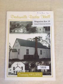
Book, Rhonda Poholke, Dadswells Bridge Hall Centenary 1905/2005, 2005
A book commemerating the Centenary of the Dadswells Bridge HallWhite Card with lime green print and border enclosing five b/w photos of the Dadswells Brigde Hall.Dadswells Bridge Hall Centenary 1905-2005stawell -
 City of Ballarat
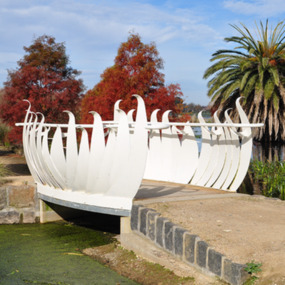
Artwork, other - Public Artwork, Swan Pool Bridge By Thomson Hay Landscape Architects, c2013
Swan Pool forms the southern gateway to the ‘Fairyland’ area on the western shore of Lake Wendouree, Ballarat. The new bridge was built c2013 and designed based on the form of water lily flowers. The sculptural form of the bridges enhances the ‘Fairyland’ experience for children and adults alike.white decorative steel bridge edgings -
 Victorian Interpretive Projects Inc.
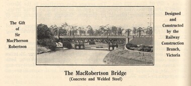
Image, MacRobertson's Bridge, 1934
Confectionery king MacPherson Robertson personally funded the £19 000 cost of the steel arch MacRobertson or Grange Road Bridge (1934) as a gift to Victoria for its centenary. (http://www.emelbourne.net.au/biogs/EM00234b.htm)A steel bridge over the Yarra River, Melbourne. The bridge was funded by MacPherson Robertson.macrobertson, bridge -
 Phillip Island and District Historical Society Inc.
Photograph, Phillip Island Bridge, 1968/9
1969 Bridge construction showing Suspension Bridge in background.Girders on partly built Bridge. Crane in background - close-up at low tide.local history, photographs, civil engineering, bridges, phillip island bridge (1969), black & white photograph, jack jenner collection, phillip island bridges, public construction -
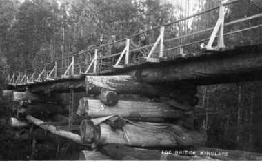 Kinglake Historical Society
Log Bridge Kinglake
post card depicting horse and cart crossing log bridge at Kinglakeearly post card of Kinglake area including bridge and transportpost card of log bridge Kinglakekinglake, post card, log bridge, horse cart -
 Phillip Island and District Historical Society Inc.
Photograph, Phillip Island Bridge
View taken from San Remo looking across bay to Phillip Island. Main section of bridge close up showing framework, arches and wires.Bridge - main sectionlocal history, photographs, bridges, san remo, black & white photograph, mona condrick -
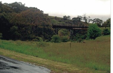 Linton and District Historical Society Inc
Photograph, Dilapidated bridge over Springdallah Creek, Happy Valley/Piggoreet, 2010
This bridge was built in the 1880s. By the 1980s it was in a dilapidated condition and was replaced. The old bridge was further damaged by storms and flooding in November 2010 and January 2011. (The newer bridge was completely washed away when the Springdallah Creek flooded in January 2011.) In 2025, little remains of the old bridge.Colour photograph of a trestle bridge spanning Springdallah Creek, Linton-Piggoreet Road.trestle bridges, old springdallah bridge -
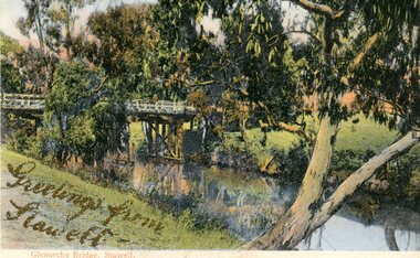 Stawell Historical Society Inc
Photograph, Greetings from Stawell - Glenorchy Bridge -- Postcard
Postcard Front - Glenorchy bridge over water with gums in colourGreetings from Stawell - Gold Pen. Bridge supports. Note from Mother. also gold pen. Also parts of trees -
 Phillip Island and District Historical Society Inc.
Photograph, Phillip Island Bridge, 1968/9
The 2nd Bridge under construction which replaced the Suspension Bridge built in 1940. From the Jack Jenner Collection.Building of second Bridge under construction between San Remo and Newhaven.local history, photographs, civil engineering, bridges, phillip island bridges, black & white photograph, jack jenner collection, public construction -
 Ringwood and District Historical Society
Photograph, Deep Creek Road bridge early 1900s
Black and white photograph taken from unmade road. Road zigzags over bridge with wooden balustrades. Bushland setting. (3 copies)Typed below photograph, "Deep Creek Road bridge in the early days". -
 Ringwood and District Historical Society
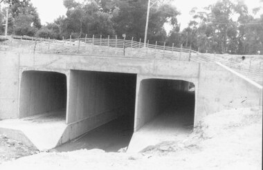
Photograph, Mullum Mullum Creek culvert installations for new bridge in Warrandyte Road, Ringwood - 19.1.1987
Culverts under new Warrandyte Rd. bridge. Mullum Mullum Creek, Ringwood 1987Written on back of photograph, "9.1.87. Culverts under new Warrandyte Rd. bridge. Mullum Mullum Creek." -
 Stawell Historical Society Inc
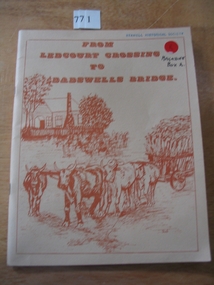
Book, Peter Davie, From Ledcourt Crossing to Dadswells Bridge, 1980
History of Dadwells bridge area. Written for the Back-To-School. 75th Anniversary Different families of the district contributed articles & Photographs Fawn Card cover with brown print and drawing of a house with a bullock wagon in front. surround by a single line borderFrom Ledcourt crossing to Dadswell Bridgestawell -
 Sunbury Family History and Heritage Society Inc.
Photograph, Bulla Bridge, c 1980s
The bridge in the photograph is the bluestone bridge at Bulla which spans the Deep Creek, a tributary of the Maribyrnong River. It was built in 1869 and replaced a ford crossing which was built further downstream. Many of the buildings and structures in the area were built from bluestone which is in abundance throughout this volcanic area.This bridge is one of many similar structures built across Western Victoria where the bluestone volcanic rock was found in abundance.A coloured close - up photograph of a four-arched blue stone bridge spanning a waterway. Some greenery is visible on either side of the bridge and above it. bulla bridge, bluestone, bridges, deep creek. -
 Greensborough Historical Society
Photograph - Digital image, Charles Marshall et al, New bridge, 1917-1918
This photograph shows a new bridge location unclear.Digital copy of black and white photograph. "New bridge [last word illegible, possibly Gaza]"charles marshall, world war 1 -
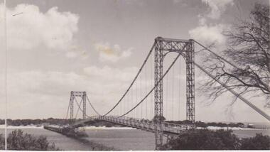
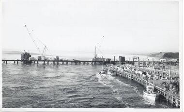 Phillip Island and District Historical Society Inc.
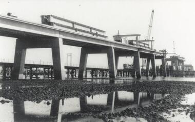
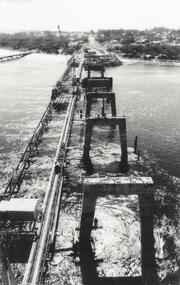
Photographs, Country Roads Board, Construction of 2nd Phillip Island Bridge 1966 - 1969, 1966 - 1969
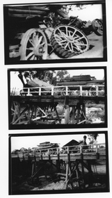
Collection of Black & White photographs of the construction of the second Phillip Island Bridge by the Country Roads Board. Contractor John Holland & Co Pty. Ltd.Black & White photographs of the Construction of the Phillip Island 2nd Bridge in 1969 351-01: View from centre of suspension bridge. 351-02: Concreting Pier 8 351-03: Concreting Pier 8 351-04,05 & 06: Metal beams. 351-07: Driving sheet Piling. 351-08:Reinforcement in caisson (watertight structure)351-01: Country Roads Board Victoria, Aust. Negative No. 67-37 - Phillip Island Bridge Project. Shire of Bass 352-02: As above - Negative No. 67-38B 352-03: As above - Negative No. 57-38D. 352-04: Negative No. 67-223A. 352-05: Negative No. 67-223B 352-06: Negative No. 67-223D 352-07: As 352-01-03 plus Negative No. 67-312 352-08: As above - Negative No. 67-272.phillip island bridge (1969), country roads board, sasha stark -
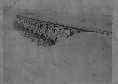
 Sunshine and District Historical Society Incorporated
Photographs (1928), 'QUARTER MILE' BRIDGE Construction, 1928
One man lost his life during the building of this bridge. The bridge was constructed by the Victorian Railways between 1927 to 1929 to carry a new double track goods line. This enabled trains from all parts of the state except Gippsland to have direct access to the Tottenham marshalling and sorting yards. These yards were constructed in the 1920's to relieve congestion in the Melbourne Yard near Spencer Street station. The congestion was being caused by the construction of suburban passenger platforms associated with the electrification of the suburban railway network. Initially the bridge was for goods trains but during the Second World War it was also used by troop trains. When the standard gauge line was built in 1962 all trains to Albury and Sydney have used this route, thus avoiding travelling through Essendon and Pascoe Vale on the suburban tracks. The standard gauge track across the bridge took the place of one of the broad gauge tracks so broad gauge trains crossing the bridge in either direction have to now use the same track. The bridge is 1,257 feet (383.13 metres) long and 180 feet (54.86 metres) above the water level. It is just 63 feet (19.2 metres) short of a quarter mile in length between abutments. There is a similar bridge on the same railway line crossing the Moonee Ponds Creek between Gowenbrae and Glenroy, however it is smaller at 1060 feet (323.08 metres) length and 115 feet (35.05) height.The bridge is now Victorian Heritage Registered under Number: H1197, and Heritage Overlay Numbers HO5, and HO107. On the Heritage Register it is named RAIL BRIDGE (ALBION VIADUCT). According to the Heritage Report the bridge is scientifically and architecturally important because of its large size, and because of the cost effective design features such as two girders per span (one for each track), the K bracing in the towers, and the broad flange beams as columns. When it was being built it was the largest trestle bridge in Australia, and until the Sydney Harbour bridge was constructed it was the highest railway bridge.Five B&W yellowing photos showing stages of construction of the Maribyrnong River Viaduct known as the Trestle Bridge but mainly known locally as the QUARTER MILE BRIDGE. It is a railway only bridge which runs over the Maribyrnong River between Sunshine North and Keilor East. A sixth image, which is not part of this set of photos, is included to show what the completed bridge looks like. -
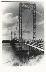 Phillip Island and District Historical Society Inc.
Photograph, Suspension Bridge, 1950's
First Suspension Bridge built 1940 between Newhaven & San Remo. Bridge opened by Hon. Albert Dunstan, Premier of Victoria. Photograph taken from San RemoBlack & White photograph of Suspension Bridge between Newhaven & San Remolocal history, photographs, film civil engineering, bridge, black & white photograph, jack jenner, phillip island bridge -
 Stawell Historical Society Inc
Photograph, Traction Engine Accident on the Joel Joel bridge -- 3 Photos
Joel Joel Bridge Traction Engine Accident. Set of three photographs. C1922 Wimmera Bridge on Stawell Road. For information on accident see third SheetThree B/W photos of an accident on a bridge. A Traction engine broke through the surface of the bridge whilst towing a trailer full of lumber. the top photo is a close up of the tractor ashowing the rear wheel still on the bridge. The Second Photo shows the tractor and trailer from left rear, while the last phot shows the Secen from the right front.shire, archie slorach, joel area, john frampton -
 Orbost & District Historical Society
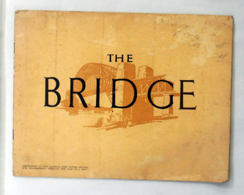
book, The Bridge, 1930's
This book was written by Dr J. J. C. Bradfield, (John Job Crew), 1867-1943. Dr JJC Bradfield was a visionary Australian engineer who worked with enormous energy and vision to build the infrastructure which he foresaw that Sydney would need as it grew. As early as 1903 Bradfield was making the case for the Sydney Harbour Bridge, in his presidential address as President of the Sydney University Engineering Society. Bradfield’s proposal — at that stage for a cantilever bridge between Dawes Point and Milsons Point — won the committee’s support and they recommended it be accepted. However, the First World War put a stop to these plans. While a bill to authorise the project passed the lower house of the NSW parliament in 1916, it failed to pass the upper house, on the grounds that funds should not be diverted from the war effort. With the war over, in 1922 the Sydney Harbour Bridge Act was passed by the NSW Parliament. The Sydney Harbour Bridge was officially opened in 1932 after Museum and St James railway stations were built. This book was written from the story broadcast by Dr. J.J.C. Bradfield. This item is a useful reference tool.A staple soft cover 16 pp booklet with a buff coloured cover. It has a sketch of the Sydney Harbour Bridge behind the title "The Bridge" in dark brown print. It contains information and photographs of the history and construction of Sydney Harbour Bridge.sydney-harbour-bridge bradfield-dr-j-j-c -
 Tatura Irrigation & Wartime Camps Museum
Photograph, Arthur Knee, Camp 13 stone bridge, 1989
Camp 13, administration area, s.w. corner near Commandants house. Made by prisoners using local stone.Camp 13, Camp Road, Murchison, Victoria. Stone work,ornamental pond, bridge, s.w. corner near administration area - remnants.Camp 13 West Garrison Gardens - Stone bridge over figure 8 poolcamp 13, murchison victoria, pow, internment camps, stonework -
 Greensborough Historical Society
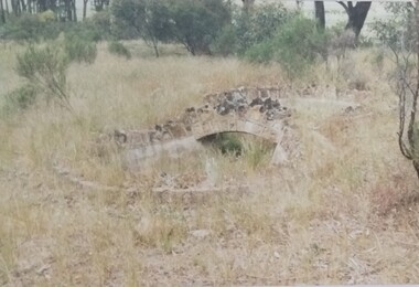
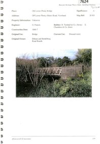
Document - Document Collection, Allom Lovell & Associates, Old Lower Plenty Bridge, 2001
Heritage citation for the Old Lower Plenty Bridge, copied from Banyule Heritage Places Study; a short history of the bridge and a news clipping, dated 2001 reporting on the re-opening of the bridge as a link in the Plenty River Trail.4 p., illus. Heritage citation, 2p.; history of bridge, 1p.; newspaper clipping, 1p. plenty river, plenty river trail, old lower plenty bridge, lower plenty -
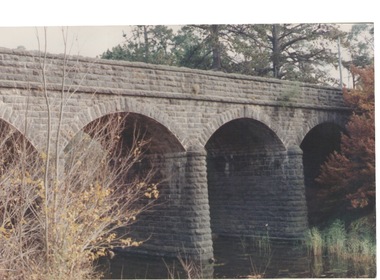
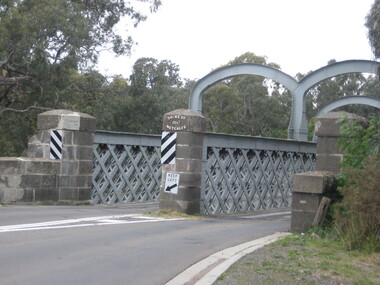 Ballarat Heritage Services
Photograph, Redesdale Bridge, 2016, 18/01/2016
The Redesdale Bridge is a wrought iron and timber structure with bluestone abutments which was installed over the Campaspe River in January 1868, although the bridge actually bears the date 1867. In 1859, the "Herald of the Morning", a ship carrying a cargo including 350 tons of ironwork for the Hawthorn bridge, caught fire and was scuttled a quarter of a mile off the jetty at Sandridge. A Melbourne salvaging firm raised the ironwork from the bottom of the bay, but after details of an arranged sale to the government caused a scandal in Parliament, the material was sold privately to the Melbourne foundry Langlands & Co. Two hundred tons of it was sold to the goldfields shires of McIvor and Metcalfe for only £1000. The bridge was designed by engineer T.B. Muntz and built by a contractor named Doran, and was completed late and considerably over budget at £6274. The bridge spans 45.7m across the river and has two roadways which are carried between three metal lattice girders in a through truss configuration. The design for the Hawthorn bridge had the deck supported over the trusses, and to stiffen the through truss configuration three sets of distinctive paired arches connect the trusses above the roadways. The roadway decking is constructed of longitudinally placed timbers on timber cross girders which rest on the lower chords of the trusses. (Heritage Victoria) A number of colour photographs showing the historic bridge at Metcalfe.metcalfe, shire of metcalfe, bridge, municipal boundary, shire of mcivor, redesdale bridge, campaspe river, t.b. muntz, doran -
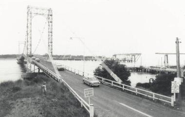 Phillip Island and District Historical Society Inc.
Photograph, Phillip Island Bridges, 1968/9
First and Second Bridge to Phillip Island. From the Jack Jenner Collection.Old Suspension Bridge with cars. San Remo jetty and partly built new Bridge in background. 1968/9 Bridge with middle span uncompleted at middle right.Signs on Bridge: Pedestrians keep right on bridge. Stoppage on bridge prohibited. Fishing from bridge prohibited.local history, photographs, civil engineering, bridges, phillip island bridge, black & white photograph, jack jenner collection, phillip island bridges, public construction -
 Stawell Historical Society Inc
Book, M. Prior nee Morgan, Dadswells Bridge - Previously Cat No 3641, 1991
Contains excerpts from Horsham papers, concerning Dadwells Bridge from the 1860's to 1985?Black covered folder, Handwritten pages in plastic sleeves. Information is from Horsham Papers.on Spine white labels Dadswells Bridge By Mil Priorstawell -
 Greensborough Historical Society
Photograph - Digital image, Charles Marshall et al, Railway bridge at Tel-el-Fara, 1917_
This photograph shows a railway bridge in Tel-el-Fara, PalestineDigital copy of black and white photograph. "Railway bridge over Waddi buzzetti [?] Tel-el Fara"charles marshall, world war 1 -
 Whitehorse Historical Society Inc.
Photograph, Lake Road Bridge Blackburn, 1962
The old bridge demolished in 1965. Photo shows John Henster and daughter standing , looking over the side.Black and white photo of bridge, Lake Road, Blackburnlake road blackburn, lake road bridge blackburn -
 Charlton Golden Grains Museum Inc
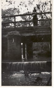
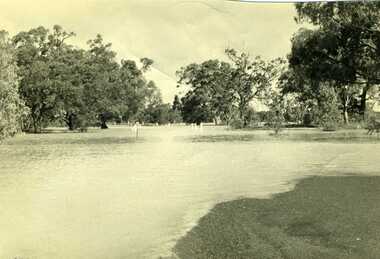
Photograph, Charlton Tribune, 1973 flood at low water bridge
1973 Flood at Charlton, Vic. At the low water bridge.Unframed photograph/ sepia of 1973 flooding of Charlton at low water bridge.flood, low water bridge -
 Kew Historical Society Inc
Photograph, J F C Farquhar, Railway Bridge Over the Yarra, 1891
At the beginning of the 1890s, the Kew businessman and Town Councillor, Henry Kellett, commissioned J.F.C. Farquhar to photograph scenes of Kew. These scenes included panoramas as well as pastoral scenes. The resulting set of twelve photographs was assembled in an album, Kew Where We Live, from which customers could select images for purchase.The preamble to the album describes that the photographs used the ‘argentic bromide’ process, now more commonly known as the gelatine silver process. This form of dry plate photography allowed for the negatives to be kept for weeks before processing, hence its value in landscape photography. The resulting images were considered to be finely grained and everlasting. Evidence of the success of Henry Kellett’s venture can be seen today, in that some of the photographs are held in national collections.It is believed that the Kew Historical Society’s copy of the Kellett album is unique and that the photographs in the book were the first copies taken from the original plates. It is the first and most important series of images produced about Kew. The individual images have proved essential in identifying buildings and places of heritage value in the district.Completed in November 1890, the railway viaduct (now the Chandler Highway Bridge) linked Kew and Fairfield. The viaduct is significant as the most substantial extant engineering remnant of the Outer Circle Railway Line. Opened in March 1891, the viaduct crossed the Yarra River in a single span, atop three supporting brick pillars. Following the closure of the railway line in 1927, and the construction of the Chandler Highway in 1930, the bridge was used for vehicular traffic. In 1891 when this panoramic photograph was taken, the grounds of what was then the Kew Lunatic Asylum extended down to the River and eastward beyond the viaduct. The landscape surrounding the Asylum was planted with traditional exotic trees such as Oaks, Pines and Cedars, and landmark trees from northern Australia such as the Hoop Pine. Remnant indigenous trees such as the River Red Gum, Yellow Box and Lightwood were scattered around the site, including beside the Yarra River.Railway Bridge Over the Yarrakew illustrated, kew where we live, photographic books, henry kellett, railway viaduct - - kew (vic) -
 Marysville & District Historical Society
Booklet - Information booklet, Ann Thomas, Wilks Creek Bridge, 1993
A history of the Wilks Creek Bridge and its connection to the Yarra Track.Paperback. Front cover has an old photograph of the Wilks Creek Bridge.non-fictionA history of the Wilks Creek Bridge and its connection to the Yarra Track.wilks creek bridge, yarra track, narbethong, marysville, victoria, clement wilks, wood's point goldfields, jordan goldfields, john monash, monash and anderson, 2009 black saturday bushfires -
 Clunes Museum
Photograph, C. NETTLETON, GOVERNMENT BRIDGE, CLUNES, SOUTH WEST
PHOTOGRAPH, - VIEW TAKEN FROM GEORGE STREET SHOWING LANDSCAPE, GOVERNMENT BRIDGE - LOOKING SOUTH WEST. .1 SEPIA PHOTOGRAPH MOUNTED ON CARDBOARD .2 SEPIA PHOTO PRINT .3 BLACK AND WHITE PHOTO PRINT .4 SMALL BLACK AND WHITE PHOTO PRINT .5 SMALL BLACK AND WHITE PHOTO PRINT GOVERNMENT BRIDGE CLUNES. SOUTH WESTlocal history, photography, photographs, bridges and buildings