Showing 227 items
matching meteorology
-
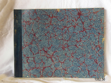
 Flagstaff Hill Maritime Museum and Village
Record Book
Warrnambool Lighthouse Register of Meteorological Observations 1907 Mayflagstaff hill, warrnambool, shipwrecked-coast, flagstaff-hill, flagstaff-hill-maritime-museum, maritime-museum, shipwreck-coast, flagstaff-hill-maritime-village, meteorological observations, book -
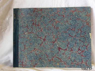
 Flagstaff Hill Maritime Museum and Village
Record Book
Warrnambool Lighthouse Register of Meteorological Observations 1907 Junflagstaff hill, warrnambool, shipwrecked-coast, flagstaff-hill, flagstaff-hill-maritime-museum, maritime-museum, shipwreck-coast, flagstaff-hill-maritime-village, meteorological observations, book -
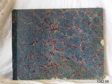
 Flagstaff Hill Maritime Museum and Village
Record Book
Warrnambool Lighthouse Register of Meteorological Observations 1907 Julflagstaff hill, warrnambool, shipwrecked-coast, flagstaff-hill, flagstaff-hill-maritime-museum, maritime-museum, shipwreck-coast, flagstaff-hill-maritime-village, meteorological observations, book -
 Flagstaff Hill Maritime Museum and Village
Record Book
Warrnambool Lighthouse Register of Meteorological Observations 1907 Augflagstaff hill, warrnambool, shipwrecked-coast, flagstaff-hill, flagstaff-hill-maritime-museum, maritime-museum, shipwreck-coast, flagstaff-hill-maritime-village, meteorological observations, book -
 Flagstaff Hill Maritime Museum and Village
Record Book
Warrnambool Lighthouse Register of Meteorological Observations 1907 Sepflagstaff hill, warrnambool, shipwrecked-coast, flagstaff-hill, flagstaff-hill-maritime-museum, maritime-museum, shipwreck-coast, flagstaff-hill-maritime-village, meteorological observations, book -
 Flagstaff Hill Maritime Museum and Village
Record Book
Warrnambool Lighthouse Register of Meteorological Observations 1907 Octflagstaff hill, warrnambool, shipwrecked-coast, flagstaff-hill, flagstaff-hill-maritime-museum, maritime-museum, shipwreck-coast, flagstaff-hill-maritime-village, meteorological observations, book -
 Flagstaff Hill Maritime Museum and Village
Record Book
Warrnambool Lighthouse Register of Meteorological Observations 1907 Novflagstaff hill, warrnambool, shipwrecked-coast, flagstaff-hill, flagstaff-hill-maritime-museum, maritime-museum, shipwreck-coast, flagstaff-hill-maritime-village, meteorological observations, book -
 Flagstaff Hill Maritime Museum and Village
Record Book
Warrnambool Lighthouse Register of Meteorological Observations 1907 Decflagstaff hill, warrnambool, shipwrecked-coast, flagstaff-hill, flagstaff-hill-maritime-museum, maritime-museum, shipwreck-coast, flagstaff-hill-maritime-village, meteorological observations, book -
 Flagstaff Hill Maritime Museum and Village
Journal - Record Book, Meteorological Observations, 1947-1948
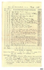
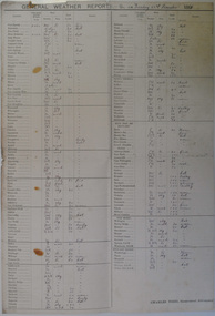
This bundel of twenty pages of meteorological observations covers the period between March 1947 and April 1948 but there are some gaps. The bundle includes handwritten records on pre-printed forms from the Commonwealth Government and brief records on plain paper. There are calculations for monthly totals of information such as rainfall, and there are some comparisons between the years. One of the forms has handwriting in three directions, which is quite unusual. Readings were recorded daily for barometer, temperature and wind. There was also a section for comments on Exceptional Phenomena such as storms and fog. . It was one of the many duties of the Lighthouse Keeper or his Assistant to keep these records and make the mathematical calculations required by the Government. Information gathered from Lighthouse Keepers' letters tells of the large amount of time taken for this detailed work and the lack of payment made for such a responsibility. The quite detailed record for May, June and July 1947 were signed by C Carrington, Harbour Master for Warrnambool. Captain Carrington was responsible to the Harborus Board. He was responsibilite for the fortnightly training of the Warrnambool Lifeboat Crew on the practice of lifesaving and using the Rocket Rescue equipment. These Meteorological Observations are an important accurate record of the local weather since the late 1899s. They are part of Flagstaff Hill's Meteorological Observations collection of over seventy record books dating from the late 19th century. The collected information gives a picture of the weather patterns for the months and seasons, which then allows for warnings of events out of the normal or extreme, such as forecasting floods or droughts.Meteorological Observations for Warrnambool March 1947 to May 1948. A bundle of unbound sheets of paper joined at the top left corner with a metal fastener. The pages are ordered from most recent on top to the oldest on bottom. The older records are on pre-printed forms and include many handwritten details. The more recent records are handwritten on plain paper. There is a line for each day of the month and lines for calculations at the bottom of the page. The handwritten Information includes readings for Barometer, Temperature, Wind and Rain. Printed: "COMMONWEALTH OF AUSTRALIA METEROLOGICAL OBSERVATIONS / Division No. 5, Vic. "flagstaff hill, warrnambool, great ocean road, shipwreck coast, flagstaff hill maritime museum and village, maritime museum, maritime village, meteorological observations, weather records, meteorology, barometer readings, temperature records, barometer records, wind records, rain records, commonwealth of australia, division 5, weather measurement, weather forecast, weather history, carrington, harbour master -
 Warrnambool and District Historical Society Inc.
Administrative record (collection) - Warrnambool Meteorological Observations, Meteorological Observations, 1950s, 1960s, 1970s, 1980s
Official Recording of Warrnambool Meteorological ObservationsTwo bound ledgers and one paperback exercise book and a folder of correspondencewarrnambool weatherwarrnambool weather -
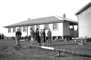
 Kiewa Valley Historical Society
Meteorological Conditions - Bogong High Plains
The amount of rain and snow during the year and over the years was recorded regularly. This was done at several sites and was important for the building of the Kiewa Hydro Electric Scheme which involved dams, power stations and racelines.The KHES depended on accurate and detailed measurements of rain and snow on the Bogong High Plains in order to plan and construct high functioning infrastructure. Photocopy of pages re the Meteorological conditions on the Bogong High Plains including the decades from the 1930s to 1980s. Snow depths are also documented.kiewa hydro electric scheme, meteorological conditions on the bogong high plains, snow depth on the bogong high plains -
 Federation University Historical Collection
Booklet, The theory and practice of ventilation in mines
52 page booklet, Includes chapters of meteorological instruments, theory of mine ventilation, third law of mine ventilation, extraction of cube root. mines, ventilation, meteorological instruments, cube root, extraction -
 Orbost & District Historical Society
weather records, 1891
Charles Todd was one of the pioneers of meteorology in Australasia. Sir Charles Todd (1826-1910) was an astronomer, meteorologist and electrical engineer. Much of the history of astronomy, meteorology and telegraphs in South Australia is contained in his reports to parliament between 1856 and 1900.This is a useful research tool.A large sheet of lined card with a printed alphabetical list of South Australian towns and hand-written details of wind direction and force. Beside each is a remark.meteorology-records-south-australia todd-charles -
 Nhill Aviation Heritage Centre
Instrument - Barometer, Aneroid Barometer, c1960s
Precision instrument used meteorological offices on air fields to measure barometric pressure141.1 Metal cube shape instrument with button switch attached is a cylindrical read out and adjuster knob. 141.2 Carry box with hinged lid and metal latch, has three hold down screws. 141.3 Stainless steel and glass thermometer 141.4 batteries 4x 15v. Standard batteries were HT Eveready B123 30v x3, LT Eveready LLII 1.5 v x1Aneroid Barometer, Type No. M.1991/A Range 800-1050mb. Ser No. 686/65, Mechanism Ltd, Made in Englandbarometer, instrument, aneroid barometer, thermometer -
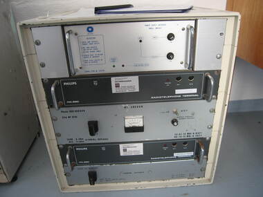 Parks Victoria - Wilsons Promontory Lightstation
Radio telephone
This Phillips FM 880 radio telephone was used by lightkeepers between 1973 and 2005 for communication with the meteorological bureau. This relatively large device is in a white enamel metal cabinet and has a number of dials and switches and instructions. It has six chrome handles. There are 'decommissioned' labels on the face."Phillips FM 880 ..." -
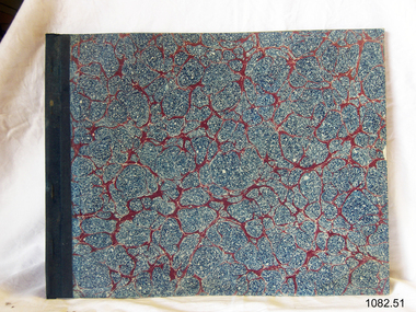
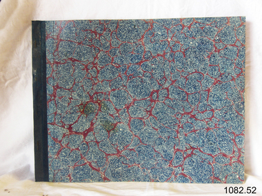
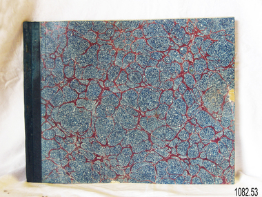
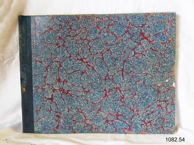
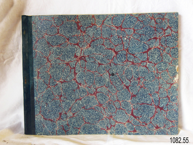
 Flagstaff Hill Maritime Museum and Village
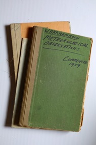
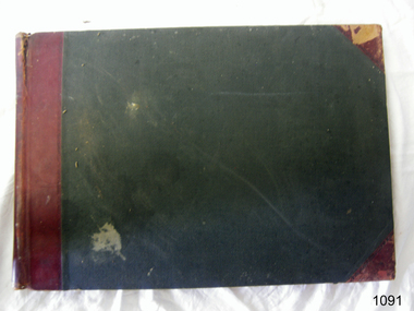
Book - Record Book, Warrnambool Lighthouse Register of Meteorological Observations 1916 Jul.jpg, 1910
Book has been completed in 1916 by Warrnambool's Lighthouse KeeperThe weather records are a significant part of Warrnambool's history, helping to tell the story of local weather patterns on land and sea. The records can be used for understanding the events of wrecks and accidents at sea.Warrnambool Lighthouse Register of Meteorological Observations 1916 July Hardcover book, green with red binding and reinforced corners. Pages have printed lines for rows and columns. Figures handwritten on each lineHandwritten recordswarrnambool, shipwreck coast, flagstaff hill, flagstaff hill maritime museum, flagstaff hill maritime village, meteorological observations, 1910, lighthouse register, weather records, lighthouse keeper -
Federation University Historical Collection
Booklet, James Curtis, Ballarat School of Mines Annual Report, 1887, 1887
94 page annual report including balance sheet. list of subscriptions and donations, professors and lecturers reports, abstract of meteorological observations taken at the Ballarat School of Mines and a catalogue of birds in the Ballarat Schooo of Mines museum. annual report, ballarat school of mines -
Moorabbin Air Museum
Book - Aerial navigation, Flightdeck The Story of Air Navigation
Overview of technical aspects of airliner operation for laymen, circa 1960sOverview of technical aspects of airliner operation for laymen, circa 1960snavigational aids, airliners, meteorology, flight planning -
 Bayside Gallery - Bayside City Council Art & Heritage Collection
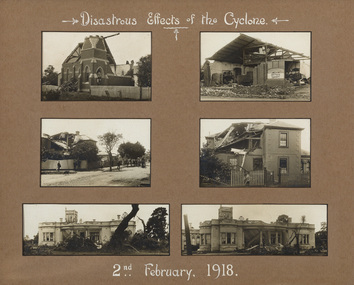
Photograph - sepia photograph, Disastrous effects of the cyclone, 1918
On 2nd February 1918, Brighton experienced the most extreme cyclone to hit a major Australian city, as recorded by the Commonwealth Bureau of Meteorology. With wind speeds estimated at 320 km/h and resulting in the deaths of two people, the event caused tremendous destruction in Brighton.cyclone, brighton, methodist church, hawthorn road, grant's hay & corn store, wells street, wellington street, billilla, weatherly, halifax street, tornado, colonel kendall -
Moorabbin Air Museum
Book - Navigation
Overview designed to assist navigator with training, circa 1943Small booklet style book.non-fictionOverview designed to assist navigator with training, circa 1943form of the earth, maps & charts, compass, meteorology, dead reckoning -
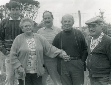 Lakes Entrance Historical Society
Photograph - Ray, Lakes Post Newspaper, 1992
Black and white photograph of a group of people Peter Dawson Weather Bureau Inspector for Victoria, Graham Duff Regional Operations Manager for Weather Bureau, Barbara and Frank Ray, Tony Langiano taken on the occasion of the retirement of Barbara Ray after 27 years at the Victorian Bureau of Meteorology Weather Station Myers Street Lakes Entrancegenealogy, retirement -
 Bendigo Historical Society Inc.
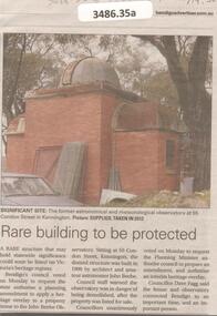
Newspaper - Articles on the former Observatory, 2024
The City of Bendigo asked for a heritage overlay over the site of a private Kennington observatory. It was once used for for the City's official meteorological readings. The observatory was built by architect John Beebe and is on the storm damaged property part of "La Rocca" house. Council approved $2 million for preservation of the site which will be integrated into a contempory complex boasting seven childcare rooms for 144 children.Bendigo Advertiser and the Herald sun: five articles on the former astronomical observatory at 55 Condon Street in Kennington.bendigo, observatory, john beebe -
 Shepparton RSL Sub Branch
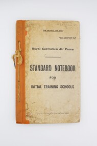
Book, Royal Australian Air Force, Standard Notebook for Initial Training Schools: Air Navigation, August 1942
This notebook contains information on air navigation and electrical science. It was issued to Roy Eliason (449852), a Shepparton local who enlisted in 1944 and served as a Leading Aircraftman with the 2nd Operational Training Unit Mildura. Contents include: Appendix I: Law, Discipline, Administration and Organisation, Hygiene and Sanitation, Notes on Meteorology, Definitions, The principles of flight, Airframes, Engine; Appendix II: Mathematics problems for revision.This notebook has significant research potential, as it bears the service number of the owner: Roy Eliason. Roy Eliason's service history is well documented in the National Archives of Australia and this book provides an insight into a period of his service. Notebooks such as this were presumably issued to new recruits in the early stages of their service. Though this copy is in fair condition with several signs of wear, these signs may in fact increase the significance of the item, demonstrating the frequent use of this item in the hands of a new recruit to the Royal Australian Air Force. Series of pages bound via twine passed through four holes along left side. Front and back cover are card with orange vinyl/fabric strip and paper cover bearing title text. Orange pages throughout mark sections. Book printed throughout.Inscribed on front cover: "449852/AC2 ELIASON R/B/2". Inscribed on interior "449852/ELIASON. R./B/2". air navigation, training, royal australian air force, raaf, eliason, world war ii, wwii, second world war -
 Parks Victoria - Gabo Island Lightstation
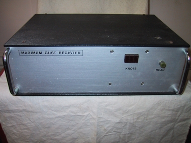
Wind Speed Recorder, "Maximum Gust Register"
Used on Gabo Island to measure maximun gust over previous 3 hours or between weather observations. Information on the back of the device implies that it was battery powered and indicates that it was used in conjunction with a Synchrotac brand anemometer. Its particular function was to measure maximum wind speed over three hours between weather observations. Like the other weather recording instruments in the collection, it became redundant to the Bureau of Meteorology’s needs. It is a good example of its kind and has first level contributory significance for its historic value and provenance to the lightstation.Black metal box with grey metal front. Two chrome plated handles at front. Red plastic square, greenish coloured knob at front with inscriptions under them.On front,"MAXIMUM GUST REGISTER / KNOTS / READ" On back, "for use with a synchrotac anemometer / ANEMOMETER / RESET" On 2 black plastic discs at back, "BATTERY x 4 " -
 Federation University Historical Collection
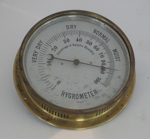
Scientific Instrument, Hygrometer
Probably used at the Ballarat School of Mines. It indicates the percentage of relative humidity .A circular dial with non-linear graduations and centre-pivot pointer. it is mounted in a brass case, with rear mounting flange. The markings on the Hygrometer at Very Dry, Dry, Normal, Moist. It has a crescent moon dial indicatorballarat school of mines, meteorology, weather, scientific instruments, scientific objects, hygrometer, relative humidity -
Moorabbin Air Museum
Book - NIGHT FLIGHT, Aviation Theory Centre Night Flight
Overview of requirements for night flying circa 2003non-fictionOverview of requirements for night flying circa 2003instruments, systems, meteorology, human factors, night flight rating rules & requirements, piloting technique, planning & navigation -
 Nhill Aviation Heritage Centre
Black and white photograph, Local photograph. Original of this scan held by Nhill Historical Society, Aeradio Building c1937
This building is still intact at the Nhill Aerodrome. Some of the infrastructure is also in place or can be evidenced by its foundations.The Aeradio building was built on the present aerodrome in 1937. This was one of only sixteen buildings of this type built across Australia and it housed radio communications and guidance equipment. The building and its equipment were part of a comprehensive system of radio towers, signalling and meteorology equipment aimed at providing safer navigation for aircraft travelling throughout Australia. The facility closed in the 1960sThis photo is significant due to it having been taken soon after the building was constructed. It is the earliest known photograph taken on an open to the public day before the receiver aerials were erected.The Aeradio building was built on the present (2012) aerodrome in 1937 or 1938. This was one of only fifteen buildings of this type built across Australia and it housed radio communications and guidance equipment. The building and its equipment were part of a comprehensive system of radio towers lights and signalling equipment aimed at providing safer navigation for aircraft travelling throughout Australia. The facility closed in the 1960sphoto, aeradio, early, civil aviation, dca, dept of civil aviation -
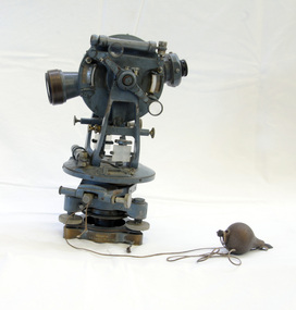 Orbost & District Historical Society
theodolite, first half 20th century
Theodolites have been used to measure horizontal and vertical angles by surveyors since the 1500s. A theodolite is a precision instrument for measuring angles in the horizontal and vertical planes. Theodolites are used mainly for surveying applications, and have been adapted for specialized purposes in fields like meteorology and rocket launch technology. Theodolites, such as this one, were instrumental to early surveyors, and would have played a significant part in their everyday work. The plumb bob was used to set the instrument exactly over a fixed survey marker.This theodolite was made by Troughton and Simms, who were significant scientific instrument makers of the 19th century and early 20th century. In 1782 John Troughton purchased Benjamin Cole's shop in Fleet Street, London enabling him to sell his own signed products. His instrument making business supported several dynasties of Troughtons before becoming Troughton and Simms and later still Cooke Troughton & Simms. This firm was one of the most well respected firms of instrument makers of the 1800s. A grey metal theodolite - probably made of brass. It has movable parts and there is a weight ( a plumb bob) attached with string.Cooke Troughton & Simms Yorke England V012318 Supplied by A. E. Parsons Melbournetheodolite scientific-instruments surveying -
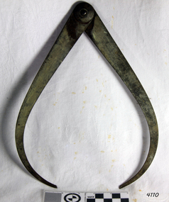 Flagstaff Hill Maritime Museum and Village
Calipers, Moore & Wright, 1925-1935
Established in 1906, Frank Moore soon became well known amongst discerning tradespeople for the quality & accuracy of his tools. The Company was acquired by John Shaw & Son in 1945 & James Neill & Co in 1970. Currently part of the Bower Meteorology UK Group, they still produce superb tools & measuring instruments in Sheffield. The subject item is made from high-grade carbon silver tool steel with the patented 'Firm Lock' joint, that identifies the maker as Moore & Wright.A tool used for external measurement of items made by a maker who patented the "firm lock" jointing system now used on many different types of tools in many different industries. These items are now collectible and quite rare as a result are sought by tool collectors in the USA and UK.‘Firm Joint’ external measuring calipers believed made by Moore & Wright. Impressed into the metal "L A J S" (Probably the owner and company that used the item nothing to do with manufacturing) flagstaff hill, warrnambool, shipwrecked-coast, flagstaff-hill, flagstaff-hill-maritime-museum, maritime-museum, shipwreck-coast, flagstaff-hill-maritime-village, calipers, callipers, external calipers, outer caliper, pottery tools, masonry tools, glass making tools, external measurement -
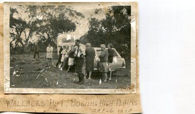 Kiewa Valley Historical Society
Photographs x 2- Bus tour of Wallaces Hut, 20/02/1970
Wallace's hut was built in 1889 and is probably the oldest surviving hut on the high plains of north-east Victoria. It was built in six weeks by Irish immigrant brothers Arthur, William and Stewart Wallace among old snow gums on a grassy plain above the snowline. The brothers held grazing leases on the High Plains and the hut was built to provide shelter for the cattlemen working there. It is probably the oldest hut on the Victorian high plains. It is part of the early history of hydroelectricity in the state and has links with early SEC meteorological data recording in the area Apart from its historical significance, Wallace’s Hut is a popular stop for tourists and photographers and is the starting point for the Wallace’s Heritage trail, which is a popular and well used hiking track, by locals and visitors alike.2 black and white photographs mounted on buff card. Photos taken during a bus trip to Wallace's Hut on Feb. 20, 1970 1. Group of local Kiewa Valley residents on a bus tour to Wallace's hut 2. Group of adults and children pictured outside Wallace's hut1. Handwritten in black ink on bottom of photo 'Wallace's Hut, Bogong High Plains, 20 Feb, 1970 2. No markingswallace's hut, bogong high plains, bush walking, cattlemen