Showing 509 items
matching mining - maps
-
 Bendigo Historical Society Inc.
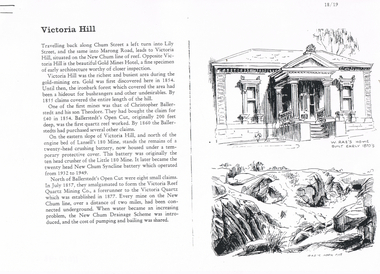
Document - LONG GULLY HISTORY GROUP COLLECTION: VICTORIA HILL
Three pages numbered 18/19, 20/21 and 22/23 titled Victoria Hill. First page has some information on Victoria Hill, a sketch of W Rae's Home and Rae's Open cut. The second page has a map of the Victoria Hill Area showing streets and the New Chum Anticline, a sketch of Ballerstedt's Open Cut and a Key to Victoria Hill Area Map. The third page mentions the Victoria Quartz mine, Tributors and quartz roasting. It also has sketch of a 20 Head Crushing Battery, Victoria Hill.bendigo, history, long gully history group, the long gully history group - victoria hill, gold mines hotel, christopher ballerstedt, theodore ballerstedt, ballerstedt's open cut, lansell's 180 mine, little 180 mine, new chum syncline battery, victoria reef quartz mining co, victoria quartz, new chum drainage scheme, a roberts and sons, tributors, william rae's bon accord mine and open cut, william rae, adventure and advance open cuts, central nell gwynne, heinz butcher shop -
 Bendigo Historical Society Inc.
Book - 'BENDIGO GOLDFIELD', 1936
Bendigo Goldfield. Produced by Mines Department Victoria Yellow cover with a map of Australia depicting the states and highlighting Victoria. Issued by Geo Brown Secretary of Mines. Underneath the Map is printed 'Mines Department, Melbourne, Victoria, Australia 1936. Maps at the back of book.Mines Department Victoriabendigo, mining, early history., bendigo - history, mining, and bendigo goldmines. -
 Bendigo Historical Society Inc.
Book - 'BULLETINS OF THE GEOLOGICAL SURVEY OF VICTORIA NO. 30'. THE PEARL AND HERCULES AND ENERGETIC MINES, BENDIGO, 1914
Bulletins of the Geological Survey of Victoria No. 30. The Pearl and Hercules and Energetic Mines, Bendigo, with plans and sections. By W. Baraganath Underground maps of the 4 (four) mines referred to in this book. Priced six pence Inscribed on the front cover: A. Richardson, 29 Harrison Street, Bendigo.Department of Mines. By W. Baraganathbendigo, mining, early history., mining, pearl, hercules and energetic mines. -
Bendigo Historical Society Inc.
Book - GETTING GOLD - AN ABC OF PROSPECTING IN AUSTRALIA, 1931
GETTING GOLD - AN ABC OF PROSPECTING IN AUSTRALIA. By 'Fossiker' An ABC of prospecting in Australia, explaining panning, cradling, puddling, dollying & sluicing. Price two shillings and six pence 42 pages with folded maps and illustrations.'Fossiker', printed by Robertson & Mullens Limited, Melbournegold, prospecting in australia, gold, mining, prospecting -
 Bendigo Historical Society Inc.
Book - INGLEWOOD GOLD GOLD TOWN OF EARLY VICTORIA 1859 - 1992, 1982
Inglewood Gold, gold town of early Victoria 1859 - 1992. 144 pages, with illustrations and maps. History of settlement and gold mining, clubs, associations, businesses. Inscription on front page ' For the Bendigo Historical Society, with compliments, Allan M. Nixon, 28/1/1989Allan M. Nixoninglewood, history, inglewood, history, gold mining. -
 Bendigo Historical Society Inc.
Book - MINING & GEOLOGICAL JOURNAL. VOL,4. NO.3, 1951
Mining and Geological Journal, Vol.4, No.3. March 1951. Published by Department of Mines Victoria with articles on Mines & mining including Bendigo mines with Photographs, Illustrations, Maps & Advertisements. Name on front A.Richardson 29 Harrison St Bendigo.Dept of Mines Victoria.gold mines, mining, mining - mines - mining equipment, central deborah mine. -
 Bendigo Historical Society Inc.
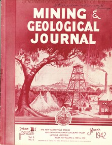
Book - MINING & GEOLOGICAL JOURNAL. VOL.S,NO.6, 1942
Mining & Geological Journal, Vol.2, No.6. March 1942. Published by Department of Mines Victoria, with articles on mines and mining including Bendigo mines, Photographs, Illustrations, Maps & Advertisements. Name on cover A Richardson 29 Harrison St Bendigo.Dept of Mines Victoriagold mines, mining, mining - mines - mining equipment. bendigo mines. -
 Bendigo Historical Society Inc.
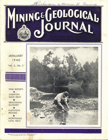
Book - MINING & GEOLOGICAL JOURNAL VOL.2, NO2, 1940
Mining & Geological Journal, January 1940, Vol.2, No.2. Published by Department of Mines Victoria, 136 pages of Mine Reports, articles on mines, photographs, illustrations, maps & advertisements. Name on cover A.Richardson 29 Harrison St Bendigo.Dept of Mines Victoriagold mines, mining, mining - mines - mining equipment, axedale - fletchers mine. -
 Bendigo Historical Society Inc.
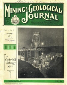
Book - MINING & GEOLOGICAL JOURNAL. VOL 1, NO.4, 1939
... Mining & Gelogical Journal Vol.1, No.4. January 1939..., illustrations, maps & advertisements. Articles on mining including some ...Mining & Gelogical Journal Vol.1, No.4. January 1939 published by the Department of Mines Government of Victoria, 72 pages with photographs, illustrations, maps & advertisements. Articles on mining including some Bendigo & district mines.Name on cover A.Richardson 29 Harrison St Bendigo.Department of Mines Victoria.magazine, organization, mining, mining - mines - mining equipment, bendigo mines.central nell gwynne. -
 Bendigo Historical Society Inc.
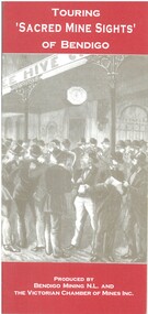
Book - TOURING 'SACRED MINE SIGHTS' OF BENDIGO, c1994
Touring 'Sacred Mine Sights' of Bendigo. Gold was discovered in 1851 and the mining era continued until 1954. Produced by Bendigo Mining NL and The Victorian Chamber of Mines Inc. Place of publication: Bendigo. 16 pages. Maps.David G Horsfallbendigo, mining, mining history guide for toursts, history bendigo mines locations -
 Bendigo Historical Society Inc.
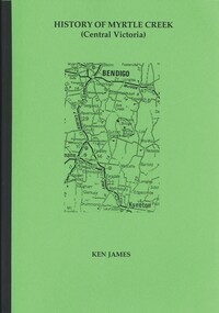
Book - HISTORY OF MYRTLE CREEK, CENTRAL VICTORIA, 2005
HISTORY OF MYRTLE CREEK, CENTRAL VICTORIA - 192 pages with photos, illustrations and maps. Letter inside from Ken James, 18 Lofty Avenue, Camberwell, 3124. 17/10/05. Inscribed on front fly page ' Donated to the Bendigo Historical Society Inc. by Ken James Oct. 2005.'Ken Jameshistory, myrtle creek, myrtle creek, cockatoo creek, state schools, ken james, gold mining, quartz mining -
 Bendigo Historical Society Inc.
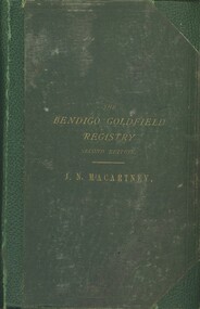
Book - THE BENDIGO GOLDFIELDS REGISTRY, c1872
The Bendigo Goldfields Registry, Second Edition. Publisher' Charles F Maxwell, Melbourne. 120 pages. Pull out maps. Table of depths (includes yields of gold per ton etc., yield claims.John Neill McCartneybendigo, mining, goldfield registry, bendigo -
 Bendigo Historical Society Inc.
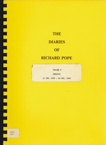
Book - THE DIARIES OF RICHARD POPE, 1879 - 1884
The Diaries of Richard Pope Volume V, Bendigo, 11 Feb. 1879 - 25 Dec 1884' 20 pages with maps.Richard Popebendigo, history, diary richard pope, bendigo, history, mining, pope family, goldfields -
 Bendigo Historical Society Inc.
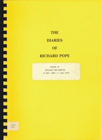
Book - THE DIARIES OF RICHARD POPE, 1869-1979
The diaries of Richard Pope, Volume IV, Ballarat and Bendigo, 14 Nov. 1869 - 4th. Jan, 1879. 90 pages, photocopied, written in script. Includes map.Richard Popebendigo, history, diary richard pope, bendigo, mining, pope family, social conditions, goldfields -
 Bendigo Historical Society Inc.
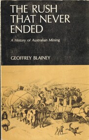
Book - THE RUSH THAT NEVER ENDED, c1969
The Rush That Never Ended A History of Australian Mining. Publisher: Melbourne University Press, Carlton. Edition: 2nd. Photographs, Illustrations and Maps. Cost $2.85 Markings/Inscriptions: Bendigo Historiacal Society. Harold Currnow 19-8-69. SBN: 522 83930 4. Notations on pae 35, 2 lines underlined.Geoffrey Blaineyaustralia, gold mining, australian gold mining -
 Bendigo Historical Society Inc.
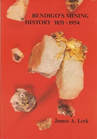
Book - BENDIGO'S MINING HISTORY 1851 - 1954, 1991
Bendigo's Mining History 1851 - 1954. Introduction and overview of gold and mining by the pioneers in the Bendigo area. Contains photographs, Illustrations and Maps. Page 1 has a letter of thanks from James Lerk to the Bendigo Historical Society for use of material in their collection. Autographed by author on 22 July 1991James A. Lerkhistory, mining -
 Bendigo Historical Society Inc.
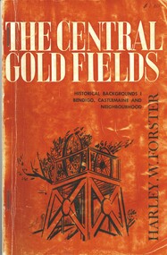
Book - THE CENTRAL GOLD FIELDS, c1969
The Central Goldfields, Historical Backgrounds Bendigo, Castlemaine and neighbourhood. Publisher Cypress Books, printed by Cambridge Press, Melbourne. 80 pages. Photographs, illustrations and maps. Inscriptions: $1.20, Bendigo Historical Society. With IndexHarley W Forsterhistory, mining, central goldfields, harley w forster -
 Bendigo Historical Society Inc.
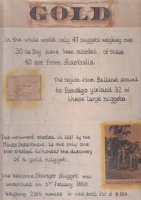
Document - 'GOLD' POSTER WITH DESCRIPTION OF NUGGETS
Poster heading - 'Gold' - 'In the whole world, only 47 nuggets weighing over 30lbs Troy have been recorded. Of these 40 are from Australia. The region from Ballarat around to Bendigo yielded 32 of these large nuggets. This monument erected in 1897 by the Mines Department, is the only one ever erected to honour the discovery of a gold nugget. The 'Welcome Stranger' nugget was unearthed on 5th February, 1869, weighing 2316 ounces and it was sold for 9.553 pounds'. Poster includes a map of Victoria depicting the main gold mining areas, also mention of gypsum, and tin in northern Victoria. A photo of the monument to the discovery of the 'Welcome Stranger' nugget found 1 1/4 miles from Moliagul in the bottom corner.document, gold -
 Bendigo Historical Society Inc.
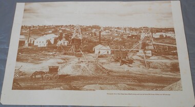
Photograph - Photograph of New Chum Line of Reef
BHS CollectionSepia coloured print of a photograph of the New Chum Line of Reef looking south from the Snobs Hill group of mines. The photo shows several poppet heads and chimneys, bridges and houses. New Chum Line of Reef. includes Victoria Hill possibly the richest spot on the field.On the back a drawing of a poppet head with the words: Bendigo gold project. A small map of Victoria is also printed on the back. bendigo mines, new chum line of reef, mining -
 Bendigo Historical Society Inc.
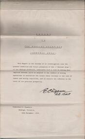
Document - REPORT ON THE BENDIGO GOLDFIELD, EDWARD DYASON
Grey cover document, 21 typed pages with map of goldfield appended. On front page 'Report on the Bendigo Goldfield Central Area. This report is the outcome of an investigation into the present condition and future prospects of the Central Area of the Bendigo goldfield, undertaken with a view to seeing what improved methods could be adopted in the conduct of mining operations to neutralise the recent heavy increase in the cost of labour and mining requisites, and so restore the industry to the level of its previous prosperity' Signed by E.C. Dyason, B.Sc. B.M.E., Commonwealth Chambers, Bendigo, Victoria, 15th November, 1918.bendigo, gold mining, report on goldfield, bendigo goldfield, goldmining, mining companies, reef lines, underground workings, e.c. dyason -
 Bendigo Historical Society Inc.
Map - BENDIGO HISTORICAL SOCIETY COLLECTION: EAGLEHAWK MINE MAP
... BENDIGO Mining eaglehawk mines Base map Australian map grid ...Base map Australian map grid of Eaglehawk area. Map has letter attached from the Department of Conservation, Forests and Lands, 22 March, 1990, addressed to Felicity Kingerlie, BHS, requesting information regarding the historic mining sites marked on the map. Sites marked are: A. Golden Age Mine, engine mountings present B. Johnson's No. 2 Mine, engine mountings, old boiler foundations C. Johnson's No. 1 Mine, mullock retaining wall made from sandstone, engine mountings, remains of old building demolished? D. Toma's Eucalyptus Factory, old boiler still there, boiler shed, chimney (remnants of) outlet drain, distilling vats, dam, remnant of winch. E. New Argus Mine,mullock heap F. New Moon Mines Dams (1) stone walls G. North Lightning Hill Mine, engine mountings, quartz retainer wall, Pascoe and Simmons open cuts and other open cuts here too H. New Prince of Wales Mine and Poppet Head I. Quarry site for stone, excavation (for miners cottages in Clarke Street) J. Lancashire open cut mine K. Virginia Hill (cynaide vats etc) L. South Prince of Wales mine, now capped and fenced M (possibly ) Catherine United Mine, engine mountings, battery mountings?bendigo, mining, eaglehawk mines -
 Bendigo Historical Society Inc.
Document - DEBORAH REEF PROJECT ENVIRONMENT EFFECTS STATEMENT
Two page document. On top, first page ' Bendigo Mining N.L., Deborah Reef Project, Environment Effects Statement, Summary Brochure'. Poppet head on top LH corner of document. A map of central Bendigo is drawn on page 1 and shows the location of the proposed processing plant near the Airport. Further maps on page 2 and 3 show the North Deborah Mine Site, the pipeline route and the airfield site. The summary brochure provides an outline of the material contained in the Environment Effects Statement and proposed planning scheme amendments upon which, the Deborah Reef Project will be assessed. Page four lists the issues that impact on this submission: planning and land use; socio economic environment; traffic; discharges to air; water management; explosives storage and handling; subsidence; heritage; flora and fauna and landscape and visual assessment. The 16th March, 1989, is the date given for submissions to be lodged in regard to this project.Bendigo Mining N.Lbendigo, mining, deborah reef project -
Bendigo Historical Society Inc.
Map - DEVONSHIRE GROUP OF MINES
... BENDIGO Mining devonshire mine Small map of Devonshire group ...Small map of Devonshire group of mines, Bendigo. Scale 8 chains to 1 Inch. Issued by M. P. Kelly sharebroker, Bendigo. Showing Hercules and Energetic, Pearl, New Victoria Catherine,, New St Mungo, xtended south devonshire, South Devonshire, United Devonshire,duchess of Edinburgh, Phoenix, South st Mungo, Lady Barkly, St. Mungo, Sadowa, Ellenborough, Williams' United, Catherine Reef United.bendigo, mining, devonshire mine -
 Bendigo Historical Society Inc.
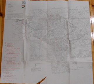
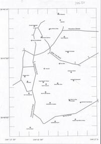
Document - CENTRAL DEBORAH GOLD MINE : GOLDEN SQUARE MINE SITES
Map showing mines in the Golden Square, Diamond Hill area. Roads include Diamond Hill Road, Burns Street, Woodward Road, Belle Vue Road, Houston Street. Latitude and Longitude on map.bendigo, mining, golden square mine sites -
 Bendigo Historical Society Inc.
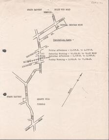
Document - ALBERT RICHARDSON COLLECTION: STATE BATTERY BELLE VUE ROAD, BENDIGO
One page document with map sowing the location of the State Battery Quarry Hill. Visitation times are given, presumably it was a tourist destination.bendigo, mining, state battery -
Bendigo Historical Society Inc.
Book - TOURING SACRED MINE SIGHTS OF BENDIGO, 1994
16 page booklet 'Touring Sacred Mine Sights of Bendigo' Produced by Bendigo Mining and the Victorian Chamber of Mines.1994. Researched and written by David Horsfall and printed by Bendigo Modern Press. Details and suggested walking and driving tours of old mine sites. Includes 3 maps.David G Horsfall -
Bendigo Historical Society Inc.
Document - STRUCTURE OF BENDIGO GOLDFIELD BULLETIN NO. 47
Booklet, 36 pages, that describes the structure of the Bendigo Goldfield. Booklet is enclosed in an envelope. On front of booklet : 1923 Victoria, Department of Mines, Bulletins of the Geological Survey of Victoria, W. Baragwanath, Director. Structure of Bendigo Goldfield, by H. Herman, late Director of Geological Survey. Maps under catalogue number 3769 accompanied the booklet and are listed as 'plates' on the contents page. Plans and Sections to accompany Bulletin No 47, Structure of Bendigo Gold-Field, by H Herman, B.C.E., M.M.E., F.G.S., late Director of Geological Survey.Geological Survey of Victoriabendigo, gold mining, structure of goldfield, bendigo, goldfield, gold mining, geology -
Bendigo Historical Society Inc.
Map - MAP: VIRGINIA MINE GARDEN GULLY LINE OF REEF
Map of Virginia Mine on the Garden Gully line of reef, Eaglehawk, transverse section. Shaft, levels and Garden Gully anticlinal axial line drawn. Key shows types of formations - quartz, spurs, sandstone, slate, cleavage, lava. This map forms part of the Geological Survey of Victoria, Structure of Bendigo Goldfield report, No. 47, 1923. H.Herman, late Director of Geological Survey.Geological Survey Victoria, Geological Survey Office, Bendigo.bendigo, gold mining, virgina mine eaglehawk, eaglehawk, bendigo, gold mining, virginia mine, garden gully line of reef. -
Bendigo Historical Society Inc.
Map - BENDIGO GOLD FIELD LONGITUDINAL VERTICAL PROJECTIONS
Bendigo gold field map showing vertical projections of portions of three anticlinal axial planes showing stratigraphical zones and caps of known saddle reefs. This map forms part of the Geological Survey of Victoria, Structure of Bendigo Goldfield report, No. 47, 1923. H.Herman, late Director of Geological Survey.Geological Survey Victoriabendigo, gold mining, vertical projections, bendigo, goldfield, gold mining, reef lines, mining companies, geological survey -
Bendigo Historical Society Inc.
Map - MINE LOCATION DRAWING AT VICTORIA HILL
Claims and shafts location for: Rae and co. - Noye and co. - Wittscheibe. Some additions to drawing made in pencil.mining, business