Showing 167 items matching "narbethong"
-
 Marysville & District Historical Society
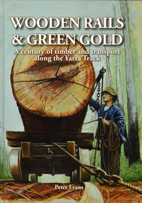
Book - Hardcover book, Peter Evans, Wooden Rails & Green Gold-A century of timber and transport along the Yarra Track, 2022
A history of the timber mills along the Yarra Track from Narbethong to Matlock.Hardcover. Shows Mick Taylor making last-minute adjustments to the rigging of a large log about to commence its journey down the incline to the Marysville Timber and Seasoning Company No.1 mill. Back cover has a photograph of a rail tractor towing a timber trolley along a timber tramway.non-fictionA history of the timber mills along the Yarra Track from Narbethong to Matlock.timber, timber mills, yarra track, narbethong, matlock, marysville, wood's point, wilks creek, great divide, cathedral range, cumberland, foresters, sawmillers, peter evans -
 Marysville & District Historical Society
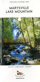
Map (Item) - Tourist map, Mystic Mountains Tourism, OFFICIAL VISITORS' MAP MARYSVILLE LAKE MOUNTAIN, Unknown
A visitors' map of Marysville and Lake Mountain produced by Mystic Mountains Tourism for Visit Victoria.A visitors' map of Marysville and Lake Mountain produced by Mystic Mountains Tourism for Visit Victoria.The Marysville and Lake Mountain Visitor Map and Touring Guide has been compiled and/ published by Mystic Mountains Tourism Inc. Copyright./ Production and artwork Graph Attack P/Lmarysville, lake mountain, victoria, australia, visitor's map, official visitors' map marysville lake mountain, buxton, narbethong, taggerty, visit victoria, mystic mountains tourism inc, graph attack p/l, mystic mountains, marysville triangle, marysville visitor information centre, marylands country house, black spur, steavenson falls, lady talbot drive, cambarville, cathedral ranges, wirreanda festival, lake mountain summit walk, summit walk loop, leadbeaters loop, day loop walk, buxton hotel, igloo roadhouse, karmann waters, silverstream b&b cottages, buxton trout and salmon farm, the niche wine bar, buxton post office & general store, choppers buxton roadhouse, woodlands rainforest bungalows, chestnut glade, black spur inn, wombat cottage, abbey lake luxury b&b spa cottages, mystic mountain ski hire & outdoors, pnl 4wdriving, blue views holiday units & ski hire, marapana agistment park & farm stay b&b, danico design, things of sand & stone, mantirri blueberry farm, allawah country cottages, amberview cottages, ashlar cottage b&b, black spur motel & caravan park, blackwood deluxe cottages, blackwood courtyard b&b, dalrymples guest cottages, delderfield, el kanah guest house, fruit salad farm, kerami guest house, keppels hotel, lake mountain-snow gum lodge, lomatia lodge, lyell guest cottages, magnolia house, keppel waters, lyrebird apartments, marysville caravan park, all view spa apartments, riverside cottages, maryton park b&b country cottages, melina cottage, mountain lodge, mystic mountains holiday cottages, nanda binya lodge, rendezvous luxury cottages, scenic b&b motel, the cumberland, south cathedral farm, tower motel, willowbank at taggerty, woodlands rainforest retreat, marysville & district country club inc, mystic mountains ski hire & outdoors, rubicon valley horse riding, marysville trout and salmon ponds, gallipoli park, keppels lookout, cambarville-yarra ranges national park, lake mountain-yarra ranges national park, lady talbot drive-yarra ranges national park, cathedral range state park, steavenson river, taggerty river, acheron river, lake mountain alpine resort, bruno's art and sculpture garden, manical mechanicals, uncle fred & aunty val's old style lolly shop, carmyle farm boutique, crossways historic country inn, fraga's, gilberts restaurant, heights licensed bistro, the old woolshed cafe, cathedral view natural therapies, crystal journey -
 Marysville & District Historical Society
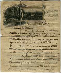
Letter (Item) - Hand written letter, John William Lindt, 1903
A letter written to Maurice Keppel by John William Lindt in 1903.A letter written to Maurice Keppel by John William Lindt in 1903. John William Lindt was born in Germany in 1845. At 17 he took a working passage to Australia on a Dutch sailing ship. Taking up work as an itinerant piano-tuner, he traveled amongst towns in Victoria and New South Wales before settling in Grafton in 1863 where he became assistant and apprentice to photographer Conrad Wagner. After a brief return to Germany in 1867 Lindt took over management of Wagner’s studio in 1869. He married Wagner’s daughter, Anna on 13 January 1872. Over 1873-1874, using the slow and laborious wet-plate collodion process, John Lindt produced photographs of the local indigenous people both in their environment conducting actual traditional ceremonies in the Clarence River district, and in his studio. Twelve of this series is included in his 1874 album Australian Aboriginals. John Lindt moved to Melbourne in 1876 where he worked for Batchelder & Co. before opening his own opulent studios at number 7 at the top of Collins Street opposite the Treasury, in 1877. John Lindt's business of this period was wide-ranging, and included portraits, records of Melbourne public buildings and streetscapes, the Botanical Gardens, and Port Melbourne. He was a welcome photographer of members of parliament and other Melbourne personalities, their society and cultural life including the theatre, and was known as a ‘rich man’s photographer’ for those whose families he grouped informally on the lawns in front of their mansions, with servants at the rails of the upstairs balconies. He continued with landscape, producing folios Fernshaw and Watt River Scenery, Victoria ( c.1878-82), Scenery on the Ovens and Buckland Rivers, Victoria (c.1878–82) and Lorne, Louttit Bay and Cape Otway Ranges (1883). Sales of his Black Spur scenery amounted to approximately 25,000 copies printed from the original negatives between 1882 and 1892. John Lindt, in collaboration with Nicholas John Caire, produced a tourist booklet on the area around "The Hermitage" in 1913. Maurice Keppel, from Ireland, was one of the first landholders in the newly surveyed town of Marysville in 1864. He and his wife ran the successful Keppel’s Australian Hotel. Two of their sons, John and Jerry, established a farm and opened up the surrounding high country. The Keppel lease was one of the longest held in the high country and the Keppel Family were amongst Marysville's pioneering families.maurice keppel, keppel family, keppel's australian hotel, marysville, victoria, john william lindt, conrad wagner, australian aboriginals, batchelder & co, nicholas john caire, anna lindt -
 Ringwood and District Historical Society
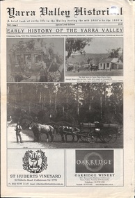
Newspaper, Yarra Valley Historical - A brief look at early life in the Yarra Valley during the mid 1800s to the 1900s (issued circa 2010)
Early History of the Yarra Valley (Vol l Issue 2) Coldstream, Yering, Christmas Hills, Steels Creek, Gulf Station, Toolangi, Tarrawarra, Healesville, Fernshaw, The Black Spur, Narbethong, Marysville. -
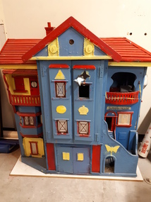 Vision Australia
Leisure object - Object, Dolls house
Dolls house used by children who resided in the RVIB nursery. Possibly made by R.F. Tunley, as the design resembles one used at Narbethong House and a picture taken at RVIB nursery refers to children playing with the Sunbeam House, however no name plate indicates this.Wooden dolls house with two doorsroyal victorian institute for the blind, richard tunley -
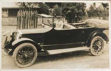 Kew Historical Society Inc
Photograph, Alice Anderson in her Hupmobile, c.1917
Alice Anderson was Australia’s first female garage proprietor when she opened her all-female business in Cotham Road (Kew, Victoria) in 1917. An authentic, rare original photograph of Miss Alice AndersonOriginal 'snap' of the Kew identity Alice Anderson in her touring car.Inscribed on mount: "Alice Anderson in her Humba - perhaps 1916. She took passengers between Melbourne and Narbethong. KH-40." Inscribed on reverse: "Sports Torquay 1917." and "1918 Miss Alice Anderson The Kew Garage ** Cotham Road. Car hire and service to motors." alice anderson, motor mechanics - kew (vic), motor mechanics - women -
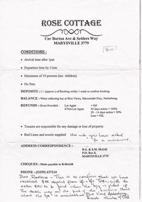 Marysville & District Historical Society
Ephemera (item) - List, ROSE COTTAGE, Unknown
A photocopy of a list of conditions and deposits paid for accommodation at Rose Cottage in Marysville. A photocopy of a list of conditions and deposits paid for accommodation at Rose Cottage in Marysville. We note you have asked/ for a microwave Dear Raelene - this is to confirm that we have/ received $180 deposit from Mr + Mrs T???, with the/ extra $180 to be paid when the key is picked up./ The sketch map on the back of the brochure shows/ where the key is available at Blue Views, Narbethong -/ Regards Shirley McGillmarysville, victoria, australia, rose cottage, accommodation, list of conditions, b.a. & s.m. mcgill -
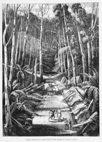 Marysville & District Historical Society
Work on paper (item) - Print of wood engraving, Ebenezer and David Syme, Road Making on the Black Spur, Road to Wood's Point, 1867
A copy of an early wood engraving of the construction of the road over the Black Spur in Victoria.A copy of an early wood engraving of the construction of the road over the Black Spur in Victoria. The Black Spur is known to be one of Victoria's most scenic drives. The road winds through a majestic forest of trees and tree ferns from Healesville to Narbethong and is part of the Maroondah Highway.black spur, wood's point, narbethong, maroondah highway, victoria, wood engraving -
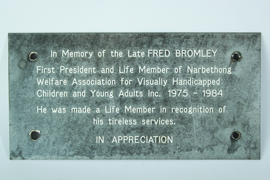 Vision Australia
Plaque - Object, Commemorative plaque: Fred Bromley
"In Memory of the Late FRED BROMLEY First President and Life Member of Narbethong Welfare Association for Visually Handicapped Children and Young Adults Inc 1975-1984. He was made a Life Member in recognition of his tireless services. IN APPRECIATION There is also a digital image of the Braille version of the plaque. Fred Bromley was a Queensland MP (1960-1974) and in addition to the above role in the Welfare Association, was also an executive member of the Lady Nell Seeing Eye Dog School, and was awarded an Order of Australia in 1984 in "recognition of service to the community, particular the welfare of disabled people".Grey flecked plastic sign with white letteringfred bromley, nameplates -
 Marysville & District Historical Society
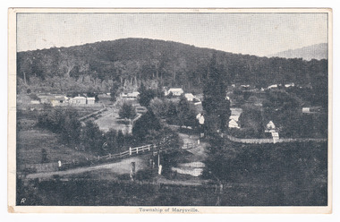
Postcard (item) - Black and white postcard, Nicholas John Caire, Township of Marysville, 1858-1918
One of a series of postcards of photographs taken by socialite photographer Nicholas John Caire. N.J. Caire had a great love for the area and in the late 1800's took many photographs of Marysville and its surrounds.One of a series of postcards of photographs taken by socialite photographer Nicholas John Caire. N.J. Caire had a great love for the area in and surrounding Marysville and in the late 1800's took many photographs of Marysville and its surrounds. N.J. Caire was born in 1837 in Guernsey. He arrived in Adelaide about 1860 along with his parents who encouraged his early interest in photography. He opened a studio in Adelaide in 1867 after traveling extensively throughout the Gippsland taking photographs. After marrying in 1870 he moved to Talbot in Victoria until 1876 when he opened a studio in the Royal Arcade in Melbourne. After 1885 N.J. Caire gave up his city work and made his home in South Yarra and devoted the rest of his life to outdoor photography, specializing in the bush, the gullies and the mountains of south-eastern Victoria. POST CARD The Address to be written on this side This space may be used for Correspondence/ within the Commonwealth at 1d. rate./ Foreign, charged ordinary letter rate. St. Fillans/ Narbethong This is the/ little village we/ visited last week/ E.L. Mrs R.D. Cole/ Mozart Villa/ Bethanga One penny Victorian postage stamp Date Stamp/ Illegible Date Stamp/ JA 16/ 6/ VICTORIA/ Illegiblemarysville, victoria, nicholas john caire, postcard, souvenir -
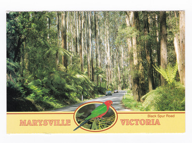 Marysville & District Historical Society
Postcard (item) - Colour postcard, Neil Cutts, Marysville Victoria-Black Spur Road, Pre 2009
A postcard in a series produced by the Rose Stereograph Company in Victoria, Australia as a souvenir of Marysville.A colour photograph of the Black Spur Road near Marysville in Victoria. The Black Spur is known to be one of Victoria's most scenic drives. The road winds through a majestic forest of trees and tree ferns from Healesville to Narbethong and is part of the Maroondah Highway. Rose Series postcard No. 3528. POST CARD The "Rose" Series/ De Luxe Proudly Printed in/ Australia Since 1880 AFFIX/ STAMP/ HERE/ Rose Series/ Post Card No./ 3528 ADDRESS/ POSTCODE Mountain Ash and Treeferns/ Black Spur Road/ MARYSVILLE, VICTORIA, AUSTRALIA/ Photo Neil Cutts Copyright Rose Stereograph Co., Glen Waverley, Victoria (03) 9560 7772marysville, victoria, black spur road, postcard, souvenir, rose series postcard, 3528, healesville, narbethong, maroondah highway -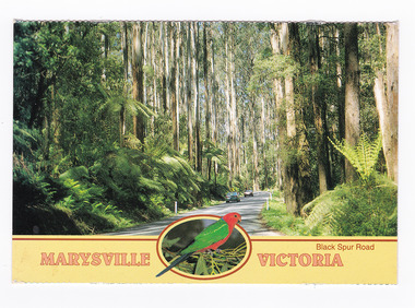
 Marysville & District Historical Society
Booklet - Information booklet, Ann Thomas, Wilks Creek Bridge, 1993
A history of the Wilks Creek Bridge and its connection to the Yarra Track.Paperback. Front cover has an old photograph of the Wilks Creek Bridge.non-fictionA history of the Wilks Creek Bridge and its connection to the Yarra Track.wilks creek bridge, yarra track, narbethong, marysville, victoria, clement wilks, wood's point goldfields, jordan goldfields, john monash, monash and anderson, 2009 black saturday bushfires -
 Marysville & District Historical Society
Photograph (Item) - Colour photograph, Pre 2009
A colour photograph of the Wilks Creek Bridge near Marysville in Victoria.A colour photograph of the Wilks Creek Bridge near Marysville in Victoria. The Wilks Creek Bridge is a former timber and bluestone road bridge on the Yarra Track, and is located just off the Black Spur route, between Narbethong and Marysville, Victoria, Australia. It was built in 1870 to the design of colonial Public Works Department engineer Clement Wilks as part of the construction of a new road to the Woods Point and Jordan Goldfields. Like many bridges of the period, it had a timber superstructure employing squared beams supported by struts and straining pieces, on cut bluestone abutments. The bridge was remodelled around 1900 by engineer John Monash of the famous bridge-engineering firm of Monash and Anderson. It was last used for heavy vehicular traffic in 1980 following the realignment of Marysville Road, and was left to decay until its demolishment in 2008. All timber traces of the bridge were destroyed in the 2009 Black Saturday fires. The handcrafted bluestone masonry wingwalls and abutments, especially shaped to receive timber struts, rate among the earliest of its kind surviving intact in Victoria.wilks creek bridge, yarra track, narbethong, marysville, victoria, clement wilks, wood's point goldfields, jordan goldfields, john monash, monash and anderson, 2009 black saturday bushfires -
 Marysville & District Historical Society
Photograph (Item) - Black and white photograph, 1993
A black and white photograph taken at the re-opening of the Wilks Creek Bridge picnic area and launch of Ann Thomas' book Wilks Creek Bridge.A black and white photograph taken at the re-opening of the Wilks Creek Bridge picnic area and launch of Ann Thomas' book Wilks Creek Bridge. The Wilks Creek Bridge is a former timber and bluestone road bridge on the Yarra Track, and is located just off the Black Spur route, between Narbethong and Marysville, Victoria, Australia. It was built in 1870 to the design of colonial Public Works Department engineer Clement Wilks as part of the construction of a new road to the Woods Point and Jordan Goldfields. Like many bridges of the period, it had a timber superstructure employing squared beams supported by struts and straining pieces, on cut bluestone abutments. The bridge was remodelled around 1900 by engineer John Monash of the famous bridge-engineering firm of Monash and Anderson. It was last used for heavy vehicular traffic in 1980 following the realignment of Marysville Road, and was left to decay until its demolishment in 2008. All timber traces of the bridge were destroyed in the 2009 Black Saturday fires. The handcrafted bluestone masonry wingwalls and abutments, especially shaped to receive timber struts, rate among the earliest of its kind surviving intact in Victoria.wilks creek bridge, yarra track, narbethong, marysville, victoria, clement wilks, wood's point goldfields, jordan goldfields, john monash, monash and anderson, 2009 black saturday bushfires -
 Marysville & District Historical Society
Document (Item) - Heritage Report, Biosis Research Pty Ltd, Heritage Report-Dismantling of Wilks Creek Brdige Deck Marysville, Unknown
A heritage report on the dismantiling of the Wilks Creek Bridge deck in Marysville in Victoria.A heritage report on the dismantiling of the Wilks Creek Bridge deck in Marysville in Victoria. The Wilks Creek Bridge is a former timber and bluestone road bridge on the Yarra Track, and is located just off the Black Spur route, between Narbethong and Marysville, Victoria, Australia. It was built in 1870 to the design of colonial Public Works Department engineer Clement Wilks as part of the construction of a new road to the Woods Point and Jordan Goldfields. Like many bridges of the period, it had a timber superstructure employing squared beams supported by struts and straining pieces, on cut bluestone abutments. The bridge was remodelled around 1900 by engineer John Monash of the famous bridge-engineering firm of Monash and Anderson. It was last used for heavy vehicular traffic in 1980 following the realignment of Marysville Road, and was left to decay until its demolishment in 2008. All timber traces of the bridge were destroyed in the 2009 Black Saturday fires. The handcrafted bluestone masonry wingwalls and abutments, especially shaped to receive timber struts, rate among the earliest of its kind surviving intact in Victoria.wilks creek bridge, yarra track, narbethong, marysville, victoria, clement wilks, wood's point goldfields, jordan goldfields, john monash, monash and anderson, 2009 black saturday bushfires -
 Marysville & District Historical Society
Map (Item) - Tourist Map, Tourists Resorts' Committee, Tourist's Map of Healesville Marysville and Warburton Districts, 13.10.1925
A tourist map for Healesville, Marysville and Warburton that was produced by the Tourists Resorts' Committee. This map was produced in 1925.A tourist map for Healesville, Marysville and Warburton that was produced by the Tourists Resorts' Committee.Photo Lithographed at the Department of Lands and Survey, Melbourne by W.J. Butson./ 13.10.25healesville, marysville, warburton, victoria, tourists resorts' committee, ben cairn, mount donna buang, the black's spur, the acheron valley, narbethong, launching place, tourist information, tourism, map, tourist map -
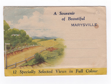 Marysville & District Historical Society
Postcard (item) - Colour photographs, Nucolorvue Productions, A Souvenir of Beautiful Marysville-12 Specially Selected Views in Full Colour, 1950's
An envelope of 12 colour photographs of attractions in and around Marysville in Victoria.An envelope of 12 colour photographs of attractions in and around Marysville in Victoria. These photographs were produced by Nucolorvue Productions in Mentone, Victoria.A Souvenir of Beautiful MARYSVILLE 12 Specially Selected Views in Full Colour Marysville, Victoria, Australia Marysville, 60 miles from Melbourne, is one of nature's/ lovely beauty spots. The invigorating mountain air helps the/ visitor to enjoy the many delightful walks amongst the tall/ timber, or through the fern glades. Apart from many excellent walking trips, Marysville district/ offers ample scope for car trips to the nearby Cumberland Forest,/ Buxton, Narbethong, or the Taggerty Valley. Skiers find Lake Mountain an attraction in the winter, whilst/ the hiker finds ample for his needs in the numerous mountain/ areas. Huge Eucalypt trees, revealing their ramrod straightness up/ to 300 feet in height, are a fitting background to the many/ beautiful creeks and waterfalls. PUBLISHED BY NUCOLORVUE PRODUCTIONS, MENTONE, VICTORIA.nicholl's lookout (image 1), eildon weir (image 2), road to lake mountain (image 3), foot of steavenson falls (image 4), steavenson falls (image 5), bush scene near marysville (image 6), bush track marysville (image 7), bridge and chalet and crossways marysville (image 8), log cabin at marysville (image 9), black spur (image 10), taggerty river (image 11), highest known hardwood tree (image 12), marysville, victoria, nucolorvue productions, postcard, souvenir -
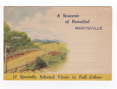 Marysville & District Historical Society
Postcard (item) - Colour photographs, Nucolorvue Productions, A Souvenir of Beautiful Marysville-12 Specially Selected Views in Full Colour, Unknown
An envelope of 12 colour photographs of attractions in and around Marysville in Victoria.An envelope of 12 colour photographs of attractions in and around Marysville in Victoria. These photographs were produced by Nucolorvue Productions in Mentone, Victoria.A Souvenir of Beautiful MARYSVILLE 12 Specially Selected Views in Full Colour Marysville, Victoria, Australia Marysville, 60 miles from Melbourne, is one of nature's/ lovely beauty spots. The invigorating mountain air helps the/ visitor to enjoy the many delightful walks amongst the tall/ timber, or through the fern glades. Apart from many excellent walking trips, Marysville district/ offers ample scope for car trips to the nearby Cumberland Forest,/ Buxton, Narbethong, or the Taggerty Valley. Skiers find Lake Mountain an attraction in the winter, whilst/ the hiker finds ample for his needs in the numerous mountain/ areas. Huge Eucalypt trees, revealing their ramrod straightness up/ to 300 feet in height, are a fitting background to the many/ beautiful creeks and waterfalls. PUBLISHED BY NUCOLORVUE PRODUCTIONS, MENTONE, VICTORIA.nicholl's lookout (image 1), eildon weir (image 2), road to lake mountain (image 3), foot of steavenson falls (image 4), steavenson falls (image 5), bush scene near marysville (image 6), bush track marysville (image 7), bridge and chalet and crossways marysville (image 8), log cabin at marysville (image 9), black spur (image 10), taggerty river (image 11), highest known hardwood tree (image 12), marysville, victoria, nucolorvue productions, postcard, souvenir -
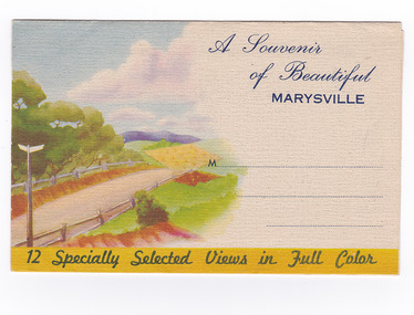 Marysville & District Historical Society
Postcard (item) - Colour photographs, Nucolorvue Productions, A Souvenir of Beautiful Marysville-12 Specially Selected Views in Full Colour, Unknown
An envelope of 12 colour photographs of attractions in and around Marysville in Victoria.An envelope of 12 colour photographs of attractions in and around Marysville in Victoria. These photographs were produced by Nucolorvue Productions in Mentone, Victoria.A Souvenir of Beautiful MARYSVILLE 12 Specially Selected Views in Full Colour Marysville, Victoria, Australia Marysville, 60 miles from Melbourne, is one of nature's/ lovely beauty spots. The invigorating mountain air helps the/ visitor to enjoy the many delightful walks amongst the tall/ timber, or through the fern glades. Apart from many excellent walking trips, Marysville district/ offers ample scope for car trips to the nearby Cumberland Forest,/ Buxton, Narbethong, or the Taggerty Valley. Skiers find Lake Mountain an attraction in the winter, whilst/ the hiker finds ample for his needs in the numerous mountain/ areas. Huge Eucalypt trees, revealing their ramrod straightness up/ to 300 feet in height, are a fitting background to the many/ beautiful creeks and waterfalls. PUBLISHED BY NUCOLORVUE PRODUCTIONS, MENTONE, VICTORIA.nicholl's lookout (image 1), eildon weir (image 2), road to lake mountain (image 3), foot of steavenson falls (image 4), steavenson falls (image 5), bush scene near marysville (image 6), bush track marysville (image 7), bridge and chalet and crossways marysville (image 8), log cabin at marysville (image 9), black spur (image 10), taggerty river (image 11), highest known hardwood tree (image 12), marysville, victoria, nucolorvue productions, postcard, souvenir -
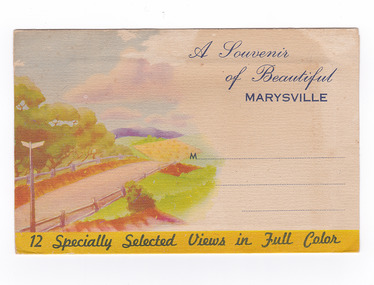 Marysville & District Historical Society
Postcard (item) - Colour photographs, Nucolorvue Productions, A Souvenir of Beautiful Marysville-12 Specially Selected Views in Full Colour, Unknown
An envelope of 12 colour photographs of attractions in and around Marysville in Victoria.An envelope of 12 colour photographs of attractions in and around Marysville in Victoria. These photographs were produced by Nucolorvue Productions in Mentone, Victoria.A Souvenir of Beautiful MARYSVILLE 12 Specially Selected Views in Full Colour Marysville, Victoria, Australia Marysville, 60 miles from Melbourne, is one of nature's/ lovely beauty spots. The invigorating mountain air helps the/ visitor to enjoy the many delightful walks amongst the tall/ timber, or through the fern glades. Apart from many excellent walking trips, Marysville district/ offers ample scope for car trips to the nearby Cumberland Forest,/ Buxton, Narbethong, or the Taggerty Valley. Skiers find Lake Mountain an attraction in the winter, whilst/ the hiker finds ample for his needs in the numerous mountain/ areas. Huge Eucalypt trees, revealing their ramrod straightness up/ to 300 feet in height, are a fitting background to the many/ beautiful creeks and waterfalls. PUBLISHED BY NUCOLORVUE PRODUCTIONS, MENTONE, VICTORIA.nicholl's lookout (image 1), eildon weir (image 2), road to lake mountain (image 3), foot of steavenson falls (image 4), steavenson falls (image 5), bush scene near marysville (image 6), bush track marysville (image 7), bridge and chalet and crossways marysville (image 8), log cabin at marysville (image 9), black spur (image 10), taggerty river (image 11), highest known hardwood tree (image 12), marysville, victoria, nucolorvue productions, postcard, souvenir -
 Marysville & District Historical Society
Ephemera (Item) - Tourist brochure, Victorian Railways, Marysville Victoria Australia, 01-1941
A tourist information brochure that was issued by the Publicity and Tourist Services of Victorian Railways, in January, 1941, to promote Marysville and the surrounding district.A tourist information brochure that was issued by the Publicity and Tourist Services of Victorian Railways, in January, 1941, to promote Marysville and the surrounding district.marysville, victoria, cumberland valley, messmate, buxton, taggerty river, acheron way, black's spur, cement creek, keppel falls, steavenson falls, cumberland falls, narbethong, st fillan, taggerty valley, wade's lookout, mount gordon, nicholls lookout, lake mountain, victorian government tourist bureau, victorian railways -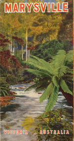
 Marysville & District Historical Society
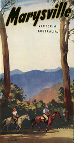
Ephemera (Item) - Tourist brochure, Victorian Railways, Marysville Victoria Australia, 01-1941
A tourist information brochure that was issued by The Victorian Railways Commissioners, in conjunction with The Marysville and District Tourist and Progress Association in 1948, to promote Marysville and the surrounding district.A tourist information brochure that was issued by The Victorian Railways Commissioners, in conjunction with The Marysville and District Tourist and Progress Association in 1948, to promote Marysville and the surrounding district.marysville, victoria, cumberland valley, messmate, buxton, taggerty river, acheron way, black's spur, cement creek, keppel falls, steavenson falls, cumberland falls, narbethong, st fillan, taggerty valley, wade's lookout, mount gordon, nicholls lookout, lake mountain, victorian government tourist bureau, victorian railways, marysville and district tourist and progress association -
 Marysville & District Historical Society
Ephemera (Item) - Tourist brochure, Victorian Railways, Marysville Victoria Australia, 01-1941
A tourist information brochure that was issued by The Victorian Railways Commissioners, in conjunction with The Marysville and District Tourist and Progress Association in 1948, to promote Marysville and the surrounding district.A tourist information brochure that was issued by The Victorian Railways Commissioners, in conjunction with The Marysville and District Tourist and Progress Association in 1948, to promote Marysville and the surrounding district.marysville, victoria, cumberland valley, messmate, buxton, taggerty river, acheron way, black's spur, cement creek, keppel falls, steavenson falls, cumberland falls, narbethong, st fillan, taggerty valley, wade's lookout, mount gordon, nicholls lookout, lake mountain, victorian government tourist bureau, victorian railways, marysville and district tourist and progress association