Showing 131 items
matching navigational instrument
-
 Flagstaff Hill Maritime Museum and Village
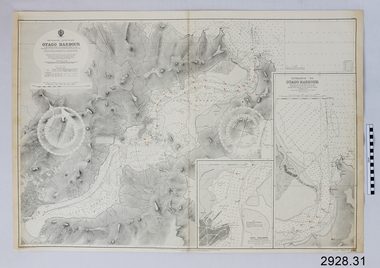
Document - Navigation Chart, British Admiralty, Otago Harbour, Late 19th to Early 20th century
... Navigation charts are used by mariners around the world ...Navigation charts are used by mariners around the world for navigating waterways. This chart was created for Otago Harbour in New Zealand. A ship "Otago' was named after this harbour and was once commanded by renowned maritime author Joseph Conrad. That ship now lies in Otago Bay, in the Derwent River, Tasmania.This navigation chart was published by the British Admiralty cartographer, to aid mariners to navigate the world's water bodies. Navigation charts are still used today, along with other navigational instruments.British Admiralty Navigation Chart - Otago Harbour, South Island, New Zealand. Chart shows insets with finer detail of important sections.warrnambool, shipwrecked-coast, flagstaff-hill, flagstaff-hill-maritime-museum, maritime-museum, shipwreck-coast, flagstaff-hill-maritime-village, shipwrecked-artefact, british admiralty navigation chart, navigation chart, british admiralty, otago harbour, south island, new zealand, otago bay, derwent river, tasmania, joseph conrad -
 Moorabbin Air Museum
Document (item) - Wackett trainer Boomerang CA15 Mustang Spitfire Mignet H.M. 14 Pou-du- Ciel Curtiss Hawk 75A-4 CurtissP-40E Kittyhawk Cloth Map South Celebes The Griff Falcon flapping wing Repco Steering Shaft M14A2401 1140 series Tugan LJW7 Monoplane Gannet Rotol contra rotating propeller Rolls Royce BS 360 engine oil system Avro York Handley Page nosewheel Douglas DC10 Auster aircraft Autocrat 5J1 Taylor aircraft Sulu Archipelago Philippines Victoria Australia radio centres FISCOM Tasmania air navigation chart Wagga Wagga Charleville navigation map Broken Hill Bourke New Guinea Bismarck sea Coral sea Solomon islands Gulf of Carpentaria Tennant creek Mackay Palau Suain east and west Nanu east and west Hauk East Aitape East Maprik West But west Rockhampton map Australian built beaufort poster Beaufighter 30 Squadron Poster Woomera 737 overhead instrument panel Uiver London to Melbourne 1934 1984 memorial flight Poster Air India to Australia Poster, Posters of aircraft navigational maps schematics of engines instrument panel drawings
-
Moorabbin Air Museum
Manual - Trans Australia Airlilnes training manuals, TAA Electrical Instrument Training Manual DC - 9 Series 31 Auto Pilot - 22 Navigation - 34
Overview of TAA Douglas DC - 9 auto pilot & navigation systems circa 1976non-fictionOverview of TAA Douglas DC - 9 auto pilot & navigation systems circa 1976 -
Moorabbin Air Museum
Manual - Trans Australia Airlines training manuals, TAA Electrical Instrument Training Manual B727 Series 100-200 Autopilot & Navigation
Overview of autopilot & navigation systems for TAA Boeing 727 - 100 to 200, circa 1975non-fictionOverview of autopilot & navigation systems for TAA Boeing 727 - 100 to 200, circa 1975 -
Moorabbin Air Museum
Book - Aerial navigation, Flight - Meteorology, Aircraft Instruments and Navigation
... Instruments and Navigation Book Aerial navigation ...Overview of basic meteorology , aircraft instrumentation & navigation, circa 1943non-fictionOverview of basic meteorology , aircraft instrumentation & navigation, circa 1943atmosphere, weather map, airway weather service, aerial photogrophy, aviation radio, aircraft instruments, aerial navigation -
 Moorabbin Air Museum
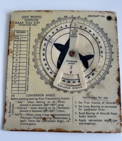
Instrument (item) - Loop Bearing Computer RAAF Form A97
... navigation. Instrument Loop Bearing Computer RAAF Form A97 ... -
 Moorabbin Air Museum
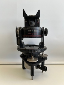
Instrument (item) - Astro Compass A.M (Air Ministry) MKII 6.A/1174
A.M Astro Compass MKII 6.A/1174 2 x -
 Wangaratta RSL Sub Branch
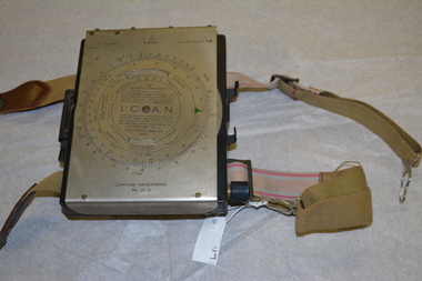
Instrument - Aircraft Navigation Computer
... beneath the flap top. Instrument Aircraft Navigation Computer ...The navigational computer was a circular slide rule used for calculating height and air speed corrections when flying an aircraft. The front cover lifts to reveal a further calculator used to solve vector triangles and plot course alterations. The device was intended to be strapped to a pilot's leg. The instrument was made by White and Gillespie (Melbourne) Pty Ltd c 1940 for the RAAF and used during WW2.Black metal box with silver metal flap top cover affixed with rotating circular rule . Two adjustable belts are affixed to the base of black box. A small spiral bound note book is contained beneath the flap top. RAAF Computer Navigational system MK. III. D. Serial No WG 2833navigation, raaf, computer, aircraft, ww2, 1940 -
 Wangaratta RSL Sub Branch
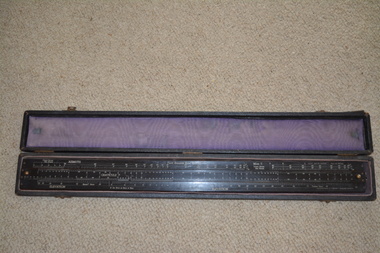
Instrument - Pilot Balloon Slide Rule
The Mark II Pilot Balloon Slide Rule was made of wood laminated with heavy white plastic with a length of 24.5-in. and width of 2.5 inches. Mark II rules were manufactured in Australia by W & G (Melbourne). The W & G rule differs only slightly from the English A. G. Thornton LTD rule. The W & G rule uses serif fonts and has some fiducial marks that the English rule lacks. Exact dates of production are not known but the MK II is known to have started production by 1927. The printed scales are engraved in the plastic faces. The slide rule has 4 captive cursors (glass windows and brass guides) that ride in slots on the top and bottom edges. Each can be moved independently of one another. The cursors are missing from this item. Brass knobs at both ends of the slide facilitate its movement. The case is fabric covered wood with felt lining. No known history for this item as located in a property after purchase. The Pilot Balloon slide rule is used to convert the observed azimuth and elevation readings into wind velocity and direction records. The use of slide rules was abandoned with the wide spread adoption of computers and programs to do the calculations, as well as the decline in the use of optical pilot balloon theodolites.Made in Australia by White & Gillespie (Melb) Pty Ltd. Established in 1910, the firm was involved mainly in printing plate manufacture, but during the Second World War it manufactured a variety of navigational aids and range finding devices for the military. About 250,000 instruments were made during that period. After the war the company produced, among other items, drawing instruments and slide rules. The long narrow case is fabric covered wood with felt fabric lining containing a long black laminate ruler with numerous white markings and numbers. Top of the ruler is in three sections with the centre section movable by small gold metal knobs at either end. This slide rule contains a engraved notation on the rear face "IMPORTANT. NORMALLY NUMBER OF GRATICULE SCALE DIVISIONS PER RADIAN (K) X LENGTH OF TAIL IN FEET (I) = 12X 105. IN OTHER CASES MULTIPLY GRATICULE READINGS BY 1.2/KI BEFORE CALCULATION ON RULE" Top of Slide Rule - RAAF Ident No G268/480 Serial WG/22pilot balloon slide rule, raaf -
Moorabbin Air Museum
Book - NIGHT FLIGHT, Aviation Theory Centre Night Flight
Overview of requirements for night flying circa 2003non-fictionOverview of requirements for night flying circa 2003instruments, systems, meteorology, human factors, night flight rating rules & requirements, piloting technique, planning & navigation -
 Bendigo Military Museum
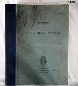
Manual - AIR MINISTRY INSTRUMENT MANUAL, British Air Ministry et al, 1937
Light blue hard cover book with Royal Coat of Arms at bottom, blue buckram binding & black print. Many pages. 11 sections on flight instruments & their use. Illustrated drawings, photos & navigational charts.Inside front cover: “A M Watkins 10”books - manuals/military/air force, british, instrument