Showing 134 items
matching navigator
-
 Mrs Aeneas Gunn Memorial Library
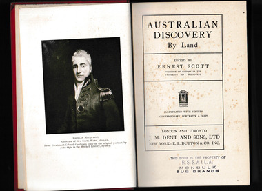
Book, Ernest Scott, Australian discovery by by land, 1929
Reproduces journals and first-hand accounts of explorers & navigators, including, Blaxland, Evans, Oxley, Cunningham, Hume & Hovell, Lockyer, Sturt, Mitchell, Eyre, Burke & Wills, Stuart. Many brief references to meetings with Aboriginal peoples.Ill, maps, p.422.non-fictionReproduces journals and first-hand accounts of explorers & navigators, including, Blaxland, Evans, Oxley, Cunningham, Hume & Hovell, Lockyer, Sturt, Mitchell, Eyre, Burke & Wills, Stuart. Many brief references to meetings with Aboriginal peoples.australia - history, australia - discovery and exploration -
 Mrs Aeneas Gunn Memorial Library
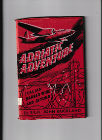
Book, Robertson and Mullens, Adriatic adventure : Italian barbed wire and beyond, 1945
Here in brief compass is the thrilling tale of air crew adventure told by its navigator, who was one of three Australian in a crew of six manning a Marauder aircraft operating from Africa over the Mediterranean. The aircraft becomes involved in combat, in which two enemy fighters are drive off, one emitting clouds of smoke; but the Marauder, too, is crippled, and comes down in the Mediterranean near the Italian Island of Ustica. Rescue from the sea is followed by the rigours of captivity in Fascist barracks and compounds, of travel through Italy, of sharing British air raids with their captors, assuming careless ease while their musical comedy soldier captors cannot conceal their unease. An ingeniously planned escape is successful; five prisoners break from the compound, and this party, with intrepidity and endurance, gain a liberty which is also a life of great hardship. Italian peasant life provides great interest, and friendly folk protect the adventurous band from the Fascists, while they meet at the coast a mysterious English Captain, who later proves to be a Commando officer on a mission; when this mission is accomplished, and not before, he helps the several groups of escapees to liberty. A motor torpedo boat calls at midnight and, within six months, home in AustraliaIll, p.87non-fictionHere in brief compass is the thrilling tale of air crew adventure told by its navigator, who was one of three Australian in a crew of six manning a Marauder aircraft operating from Africa over the Mediterranean. The aircraft becomes involved in combat, in which two enemy fighters are drive off, one emitting clouds of smoke; but the Marauder, too, is crippled, and comes down in the Mediterranean near the Italian Island of Ustica. Rescue from the sea is followed by the rigours of captivity in Fascist barracks and compounds, of travel through Italy, of sharing British air raids with their captors, assuming careless ease while their musical comedy soldier captors cannot conceal their unease. An ingeniously planned escape is successful; five prisoners break from the compound, and this party, with intrepidity and endurance, gain a liberty which is also a life of great hardship. Italian peasant life provides great interest, and friendly folk protect the adventurous band from the Fascists, while they meet at the coast a mysterious English Captain, who later proves to be a Commando officer on a mission; when this mission is accomplished, and not before, he helps the several groups of escapees to liberty. A motor torpedo boat calls at midnight and, within six months, home in Australiaworld war 1939-1945 - aerial operations - australia, world war 1939-1945 - prisoners of war -
 Wodonga & District Historical Society Inc
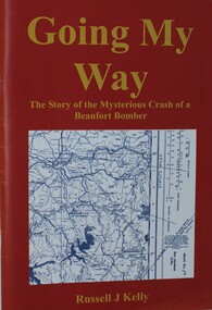
Book - Going My Way, Russell J Kelly, Going My Way - The story of the Mysterious Crash of a Beaufort Bomber, 2000
This book tracks the crash of the RAAF Beaufort, A9-228 which crashed in the mountains near Eskdale, Victoria and the search to locate the wreckage. On the night of 4 June 1945, just weeks before the end of World War 1, a Beaufort Bomber went missing whilst conducting a navigational exercise between Mount Gambier in South Australia and Sale in Victoria.The aircraft was meant to head east, but instead it headed north east due to a series of navigational errors. It flew over Albury, circled and then headed towards the Victorian Alps. It flew over the town of Eskdale in Northeast Victoria and crashed into the side of Mount Tawonga. All crew on board perished. Those lost were Flight Officer Don Flavel (pilot), Flight Officer Robert Clayton (navigator), Flight Officer Fred Wallis and Flight Sergeant L. J. Sims (radio operator). At the time of the crash, many members of the Eskdale community were in the public hall just beginning to watch a screening of the Bing Crosby movie, "Going My Way". This accounts for the title of the publication.A 62 page book outlining the loss of the Beaufort Bomber and the search to locate it. The book includes maps, illustrations and a bibliography. The cover features a map of the search area for the bomber.This book tracks the crash of the RAAF Beaufort, A9-228 which crashed in the mountains near Eskdale, Victoria and the search to locate the wreckage. On the night of 4 June 1945, just weeks before the end of World War 1, a Beaufort Bomber went missing whilst conducting a navigational exercise between Mount Gambier in South Australia and Sale in Victoria.The aircraft was meant to head east, but instead it headed north east due to a series of navigational errors. It flew over Albury, circled and then headed towards the Victorian Alps. It flew over the town of Eskdale in Northeast Victoria and crashed into the side of Mount Tawonga. All crew on board perished. Those lost were Flight Officer Don Flavel (pilot), Flight Officer Robert Clayton (navigator), Flight Officer Fred Wallis and Flight Sergeant L. J. Sims (radio operator). At the time of the crash, many members of the Eskdale community were in the public hall just beginning to watch a screening of the Bing Crosby movie, "Going My Way". This accounts for the title of the publication.beaufort bomber crash 1945, beaufort bomber eskdale, aircraft accidents victoria -
 Moorabbin Air Museum
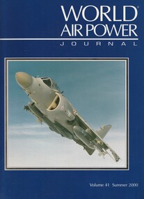
Book (item) - (SP) World Air Power Journal 41 Summer 2000
hms ocean in bright star 99, briefings: mig fighters at maks ’99, interfet air ops in east timor, usn nfo/wso/navigator training, tactical leadership programme feature, aerostar mig-21 lancer feature, fuerza aerea nicaraguense photo feature, swedish defence helicopter wing feature, focus aircraft: bae systems sea harrier (41 pages), romania’s harbin h-5 photo feature, variant briefing: ilyushin il-18 family, vmft-401 ‘snipers’ usmc adversary unit photo feature, air power analysis: malaysia & singapore -
 Moorabbin Air Museum
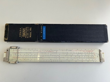
Equipment (Item) - Trigonometrical Slide Rule Dualface W&G Model 476
Was originally owned by Flt Lieutenant Donald Wilson RAAF navigator,service number 409636,posting at discharge 34 Squadron -
 Clunes Museum
Book, PAUL HAMLYN PTL LTD, AUSTRALIA - THE FIRST HUNDRED YEARS, 1978
THE PICTURESQUE ATLAS WAS DESINGED TO GIVE A GRAPHIC AND SUMMARISED CONCEPTION OF AUSTRALASIAN HISTORY AND LIFE FROM THE OF THE EARLIEST PRTUGUESE, SPANISH, DUTCH, ENGLISH AND FRENCH NAVIGATORS...YELLOW PAPERBACK BOOK WITH ADHESIVE PLASTIC COVER. ON THE COVER FEATURES A DRAWING OF CIRCULAR QUAY. WEST SIDE. "BEING A FACSIMILE OF VOLUMES 1 AND 2 OF THE PICTURESQUE ATLAS OF AUSTRALASIA 1888", EDITED BY THE HON. ANDREW GARRAN. M.A., L.L.D/M.L.C. ILLUSTRATED WITH 700 ENGRAVINGS ON STEEL AND WOOD 530 PAGES + 26 PAGES OF FULL-PAGE ENGRAVINGSnon-fictionTHE PICTURESQUE ATLAS WAS DESINGED TO GIVE A GRAPHIC AND SUMMARISED CONCEPTION OF AUSTRALASIAN HISTORY AND LIFE FROM THE OF THE EARLIEST PRTUGUESE, SPANISH, DUTCH, ENGLISH AND FRENCH NAVIGATORS...the first hundred years, picturesque atlas of australia -
 Moorabbin Air Museum
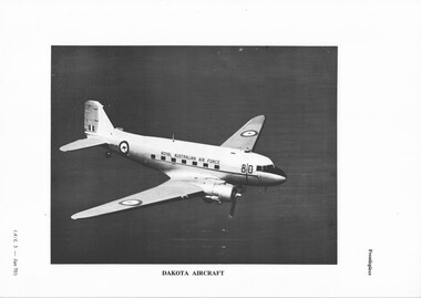
Photograph (item) - AAP980 Dakota Aircraft Plates and Photos of cockpit navigator equipment instruments and internal views of fuselage
-
 Flagstaff Hill Maritime Museum and Village
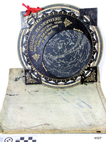
Planisphere, Early 20th Century
The word Planisphere (Latin planisphaerium) was originally used in the second century by Claudius Ptolemy to describe the representation of a spherical Earth by a map drawn in the plane. This usage continued into the Renaissance: for example Gerardus Mercator described his 1569 world map as a Planisphere. The word describes the representation of the star-filled celestial sphere on the plane. The first star chart to have the name "Planisphere" was made in 1624 by Jacob Bartsch. Bartsch was the son-in-law of Johannes Kepler, discoverer of Kepler's laws of planetary motion. A significant item of celestial mapping used by marine navigators This particular item was made and used in the first quarter to half of the 20th centuryPlanisphere of northern hemisphere, with canvas bag. Planisphere consists of a circular star chart attached at its centre to an opaque circular overlay that has a clear elliptical window or hole so that only a portion of the sky map will be visible in the window or hole area at any given time. The chart and overlay are mounted so that they are free to rotate about a common pivot point at their centres. The star chart contains the brightest stars, constellations and (possibly) deep-sky objects visible from a particular latitude on Earth. The night sky that one sees from the Earth depends on whether the observer is in the northern or southern hemispheres and the latitude. A Planisphere window is designed for a particular latitude and will be accurate enough for a certain band either side of that. Planisphere makers will usually offer them in a number of versions for different latitudes. Planispheres only show the stars visible from the observer's latitude; stars below the horizon are not included. A complete twenty-four-hour time cycle is marked on the rim of the overlay. A full twelve months of calendar dates are marked on the rim of the starchart. The window is marked to show the direction of the eastern and western horizons. The disc and overlay are adjusted so that the observer's local time of day on the overlay corresponds to that day's date on the star chart disc. The portion of the star chart visible in the window then represents (with a distortion because it is a flat surface representing a spherical volume) the distribution of stars in the sky at that moment for the Planispheres designed location. Users hold the Planisphere above their head with the eastern and western horizons correctly aligned to match the chart to actual star positions. "Made in Germany for GEORGE PHILIP & SONS Ltd. Geographical and Educational Depot, 32 Fleet Street, London" Canvas bag has "Capt. H (Howard) Tyler from Captain H. F. Woolf" "Tyler 22 ? St East Brighton" also "13 Halls St Flinders"flagstaff hill, warrnambool, shipwrecked-coast, flagstaff-hill, flagstaff-hill-maritime-museum, maritime-museum, shipwreck-coast, flagstaff-hill-maritime-village, planisphere, star map, marine navigation, maps, george philip & sons -
 Flagstaff Hill Maritime Museum and Village
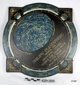
Planisphere, Early 20th Century
The word Planisphere (Latin planisphaerium) was originally used in the second century by Claudius Ptolemy to describe the representation of a spherical Earth by a map drawn in the plane. This usage continued into the Renaissance: for example Gerardus Mercator described his 1569 world map as a Planisphere. The word describes the representation of the star-filled celestial sphere on the plane. The first star chart to have the name "Planisphere" was made in 1624 by Jacob Bartsch. Bartsch was the son-in-law of Johannes Kepler, discoverer of Kepler's laws of planetary motionA significant item of celestial mapping used by marine navigators This particular item was made and used in the first quarter to half of the 20th century.Planisphere consists of a circular star chart attached at its centre to an opaque circular overlay that has a clear elliptical window or hole so that only a portion of the sky map will be visible in the window or hole area at any given time. The chart and overlay are mounted so that they are free to rotate about a common pivot point at their centers. The star chart contains the brightest stars, constellations and (possibly) deep-sky objects visible from a particular latitude on Earth. The night sky that one sees from the Earth depends on whether the observer is in the northern or southern hemispheres and the latitude. A Planisphere window is designed for a particular latitude and will be accurate enough for a certain band either side of that. Planisphere makers will usually offer them in a number of versions for different latitudes. Planispheres only show the stars visible from the observer's latitude; stars below the horizon are not included. A complete twenty-four-hour time cycle is marked on the rim of the overlay. A full twelve months of calendar dates are marked on the rim of the star chart. The window is marked to show the direction of the eastern and western horizons. The disc and overlay are adjusted so that the observer's local time of day on the overlay corresponds to that day's date on the star chart disc. The portion of the star chart visible in the window then represents (with a distortion because it is a flat surface representing a spherical volume) the distribution of stars in the sky at that moment for the Planispheres designed location. Users hold the Planisphere above their head with the eastern and western horizons correctly aligned to match the chart to actual star positions. "Sold by J DONNE & SON, Booksellers & Stationers, 349 Post Office Place Melbourne 349. Admiralty Chart Agents" and " Made in Germany for George Philip & Son Ltd" England . Signature "Capt E. B. ?..id, 22 Baund St"flagstaff hill, warrnambool, shipwrecked-coast, flagstaff-hill, flagstaff-hill-maritime-museum, maritime-museum, shipwreck-coast, flagstaff-hill-maritime-village, star map, marine navigation, maps, george philip & sons -
Moorabbin Air Museum
Manual (collection) - RAAF C130H Flight Crew Checklist Navigators
-
Moorabbin Air Museum
Book - Gatty, BRUCE BROWN, Gatty PRINCE OF NAVIGATORS, 1997
-
Port Melbourne Historical & Preservation Society
Photograph - Shipping at Station Pier and Webb Dock, Port Melbourne, 2001
further updates from the collection of Ron Laing great coverage of Port Melbourne photographs donated to the Society11 colour photographs of shipping at Station Pier and nearby Webb Dock, cruise and naval vessels (.11 currently absent March 2014)transport - shipping, piers and wharves - station pier, pacific sky, regal princess, seven seas navigator, tasmanian achiever - brambles ro ro, hmas darwin, hmas adelaide, hmas anzac, hmas warramunga, n z tekaha, hmas wallaroo -
Moorabbin Air Museum
Book - Meteorology, Meteorological Handbook for Pilots and Navigators
UK air ministry overview of meteorology for pilots & navigators, circa 1942non-fictionUK air ministry overview of meteorology for pilots & navigators, circa 1942cloud & fog, weather, air density, visibility, altimeters, weather maps, miscellaneous -
Moorabbin Air Museum
Book - Navigation
Overview designed to assist navigator with training, circa 1943Small booklet style book.non-fictionOverview designed to assist navigator with training, circa 1943form of the earth, maps & charts, compass, meteorology, dead reckoning