Showing 165 items matching "north sea"
-
 Kew Historical Society Inc
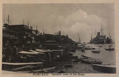
Postcard, The Cairo Postcard Trust, Port Said – General View of the Quay, c.1918
One of a number of 'real photo' and commercial postcards created by or owned by members of the Christian and Washfold families of Kew. The postcards are part of a larger collection of photographs, postcards and publications donated to the collection in May 2021.Sepia postcard of quay at Port Said, located on the north east coast of Egypt on the Mediterranean Sea, showing buildings and boats at left and two ocean liners at rightwashfold family, christian family, postcards -- port said, christian-washfold family -
 Kew Historical Society Inc
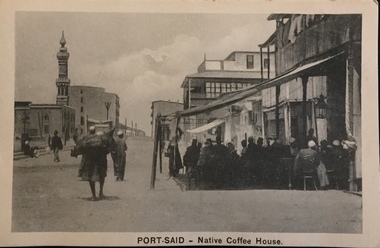
Postcard, The Cairo Postcard Trust, Port Said - Native Coffee House, c.1918
One of a number of 'real photo' and commercial postcards created by or owned by members of the Christian and Washfold families of Kew. The postcards are part of a larger collection of photographs, postcards and publications donated to the collection in May 2021.Sepia postcard of Port Said, located on the north east coast of Egypt on the Mediterranean Sea, showing mosque and minaret at left and coffee house in foreground at right.The Caro Postcard Trust Cairo 959 / Serie 632washfold family, christian family, postcards -- port said, christian-washfold collection -
 Kew Historical Society Inc
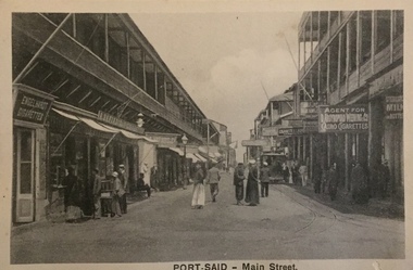
Postcard, The Cairo Postcard Trust, Port Said - Main Street, c.1918
One of a number of 'real photo' and commercial postcards created by or owned by members of the Christian and Washfold families of Kew. The postcards are part of a larger collection of photographs, postcards and publications donated to the collection in May 2021.Sepia postcard of main street in Port Said, located on the north east coast of Egypt on the Mediterranean Sea, showing buildings and stalls lining street.The Cairo Postcard Trust Cairo 953 / Serle 832washfold family, christian family, postcards -- port said, christian-washfold collection -
 Kew Historical Society Inc
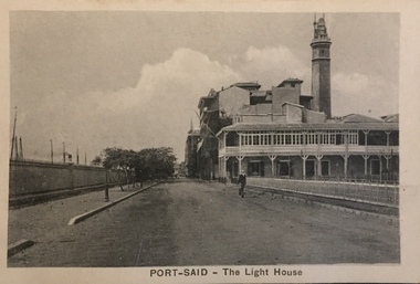
Postcard, The Cairo Postcard Trust, Port-Said - The Lighthouse, c.1918
One of a number of 'real photo' and commercial postcards created by or owned by members of the Christian and Washfold families of Kew. The postcards are part of a larger collection of photographs, postcards and publications donated to the collection in May 2021.Sepia postcard of Lighthouse at Port Said, located on the north east coast of Egypt on the Mediterranean Sea.The Cairo Postcard Trust Cairo 957 / Serle 632washfold family, postcards -- port said, christian family, christian-washfold collection -
 Kew Historical Society Inc
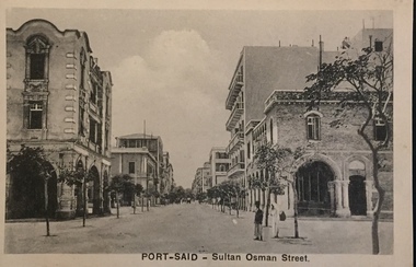
Postcard, The Cairo Postcard Trust, Port Said - Sultan Osman Street, c.1918
One of a number of 'real photo' and commercial postcards created by or owned by members of the Christian and Washfold families of Kew. The postcards are part of a larger collection of photographs, postcards and publications donated to the collection in May 2021.Sepia postcard of quay at Port Said, located on the north east coast of Egypt on the Mediterranean Sea, showing buildings lining Sultan Osman StreetThe Cairo Postcard Trust Cairo 962 / Serle 632washfold family, christian family, postcards -- port said, christian-washfold collection -
 Kew Historical Society Inc
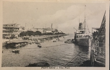
Postcard, The Cairo Postcard Trust, Port Said - The Port, c.1918
One of a number of 'real photo' and commercial postcards created by or owned by members of the Christian and Washfold families of Kew. The postcards are part of a larger collection of photographs, postcards and publications donated to the collection in May 2021.Sepia postcard of the Port at Port Said, located on the north east coast of Egypt on the Mediterranean Sea, showing buildings including the Savoy Hotel and boats at left and ocean liner at rightThe Cairo Postcard Trust Cairo 949. Serie 632christian-washfold collection, postcards -- port said (egypt) -
 Kew Historical Society Inc
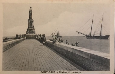
Postcard, The Cairo Postcard Trust, Port Said - Statue of Lesseps, c.1918
One of a series of postcards of Port Said, probably purchased at the end of the First World War and brought back to Australia by a member of the Christian or Washfold Families.Sepia postcard of quay at Port Said, located on the north east coast of Egypt on the Mediterranean Sea, showing statue of Lesseps, dhow and schooner. The Cairo Postcard Trust Cairo 956 / Serle 632washfold family, port said - postcards, statue of lesseps, postcards - port said, christian-washfold collection, wwi -
 Kew Historical Society Inc
Map, MMBW, MMBW Plan No.117 Heidelberg & Kew, 1900-1910
The Melbourne and Metropolitan Board of Works (MMBW) was established by an act of the Victorian Parliament in 1890 to prepare for and to implement a sewerage and water reticulation system across what was then inner Melbourne, its surrounding and middle distance suburbs, including Kew. The MMBW was disbanded in 1991.The map collection of the Kew Historical Society has at its core the historic maps assembled and originally stored in the City Engineer's Department of the City of Kew. These include maps in a number of scales. The vast majority of maps were produced by the MMBW in the first two decades of the twentieth century, and are solid working maps, backed by linen for durability. These maps are historically significant to Kew, the City of Boroondara and to the history of the development of state utilities in Victoria. A number of the Kew maps have additional details added by former municipal officers, including the levels reached by various floods. As these were working documents, information was added to them long after the period of their initial production and distribution.Early map of part of the Borough of Kew, created in the early twentieth century, at a scale 160 ft to 1 inch. The map covers what was then the north eastern part of Kew showing the natural landscape and limited development on the south side of the Yarra River. In the Kew section, south of the river, the land is occupied currently by the Greenacres and Kew Golf Clubs. The map shows the extent of urban development by that time and the outlines of the few built structures in the municipality. The height above sea level of all parts of the landscape are indicated numerically in feet. Contour lines and the levels of historic floods were added in ink to the map at a later stage. MELBOURNE AND METROPOLITAN BOARD OF WORKS / PLAN NO. 117 / HEIDELBERG & KEW melbourne & metropolitan board of works, mmbw maps, borough of kew, cartography, mmbw plan no. 117, kew (vic.) -- maps, heidelberg (vic.) -- maps -
 Surrey Hills Historical Society Collection
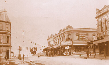
Photograph, Kenneth (Ken) Tudor Hall, Alfred Davies grocery store, corner Canterbury and Union Roads, 1906 or 1909, Original: 1906 or 1909; Copy photo by Ken Hall c1982
Ref: Mr & Mrs J Davies, Greensborough - Alfred Davies took over this store in 1904. He lived with his wife, Lucretia and 5 children above the store. His son Cyril recalled sleeping on the corner balcony on hot nights. Alfred Davies was a strong Temperance man and gave up the store when clients pressured him to collect their beer from the hotel opposite and deliver it with their grocery orders. The pharmacy moved across the road to this corner in 1936 when acquired by Dartnells. The corner shop in Woodheads building was a store and other businesses over the years. The "Druggist" on right, in Hansen's Exchange building, was established in 1889. From 1910 Percy Cathcart conducted the pharmacy there until 1936 when he was joined by Vic Dartnell, his cousin. In 1940, Vic transferred the business to Woodheads corner. His son John followed as a pharmacist until his daughter Amanda became the pharmacist. After the Dartnell family sold the business, the pharmacy continued in a similar manner as a compounding pharmacy and retained 'Dartnell' in its name.This documents the importance given to celebration of the British Empire in the Surrey Hills area in the first half of the 20th century. It also documents the earliest centre of business activity in the area with 2 major sets of dual occupancy residential and retail terraces - the Woodhead buildings and Hansen's Exchange, the later set of terraces having been demolished c1971.Sepia photo of the corner of Canterbury and Union Roads in 1906 or 1909 festooned with flags and lanterns for Empire Day celebrations. On the SE corner is Alfred Davies grocery store with advertising signs for Rosella jams and Southern Seas soap. There are people standing on a balcony above the Rosella advertising sign. Other adults and children stand in the street and there is a cab outside the draper's further east in Canterbury Road. On the opposite corner to Alfred Davies is a druggist and on the north-west corner is McNeil's Family Hotel.mcneil's family hotel, empire day, festivals and celebrations, grocers, pharmacists, alfred davies, businesses, woodhead's buildings, john woodhead, percy cathcart, hansen's exchange, hansen's folly -
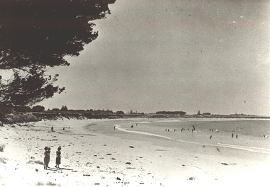 Port Fairy Historical Society Museum and Archives
Photograph
Black and white Photograph of the East Beach looking North from Battery Lane with people bathing in the middle groundeast beach, ocean, beach, sea, dunes -
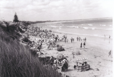 Port Fairy Historical Society Museum and Archives
Photograph
... beach north people crowd dune sea Black and white photograph ...East Beach looking NorthBlack and white photograph of Crowds of people on East Beach east beach, north, people, crowd, dune, sea -
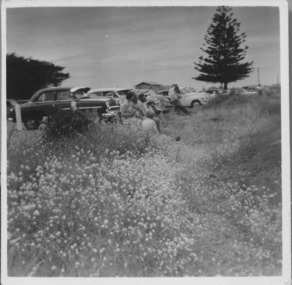 Port Fairy Historical Society Museum and Archives
Photograph, East Beach parking 1950-1960s
East Beach parking 1950-1960s looking North and upwards from the beach trackBlack and white landscape showing cars parked overlooking the East Beach with a Norfolk Island pine in the backgroundbeach, sea, seascape, east beach, norfolk island pine -
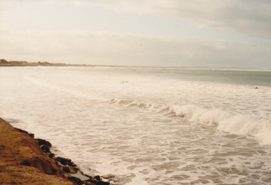 Port Fairy Historical Society Museum and Archives
Photograph
... Street Port Fairy great-ocean-road East Beach looking North East ...East Beach looking Northeast beach, sea, rough, ocean, dune, tide -
 City of Greater Bendigo - Civic Collection
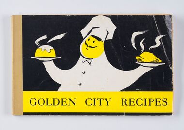
Book - Cookbook, The Neale Street North Pre-School Mothers' Club Committee, Golden City Recipes, 1963
This cookbook was compiled by the Neale Street North Pre School Mothers' Club Committee with the forward written by Anne Galvin O.B.E, President of the Bendigo & District Pre-school Association. Anne Galvin was one of Bendigo's best known charity workers and she used her first speech as Mayoress (1944) to indicate her intentions to assist mothers and children. This recipe book includes contributions by the Mayoress of the day (Mayoress Rae), Television Hostesses Corinne Kirby and Ruth Nye and Mrs Bolte and Lady Brooks. Illustrator of front cover unknown.Bound and printed cookbook containing one hundred and eight pages of recipes and advertisements including forward written by Anne E. Galvin. Colour cover, stapled on left hand side. Advertisements for local businesses include Gordon H. Hall Beauty Salon, Gas and Fuel Corporation, Hesse Bros. Electrical and Sandhurst Milk & Cream, Recipe categories include: By Special Request; Soups; Sea Foods; Meat and Poulty (sic) Dishes; Hot Sweets and Puddings; Cold Sweets; Meals in a Hurry; Salads and Dressings; Savouries and Fillings, Icings, etc; Cakes Large and Small, Biscuits; Scones, Buns and Loaves; Jams, Pickles and Preserves; Gravies and Sauces; Confectionery; Weights and Measures; Index to Advertisers; Beauty Hints. city of greater bendigo education, city of bendigo mayoress, mayoress galvin, mayoress rae, cambridge press, mayor w cambridge, anne galven -
 Mrs Aeneas Gunn Memorial Library
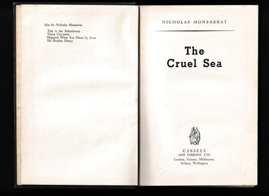
Book, Cassell, The Cruel sea, 1953
Based on the author's own vivid experiences, The Cruel Sea is the nail-biting story of the crew of HMS Compass Rose, a corvette assigned to protect convoys during World War II.Darting back and forth across the icy North Atlantic, Compass Rose played a deadly cat-and-mouse game with packs of German U-boats lying in wait beneath the ocean waves.Packed with tension and vivid descriptions of agonizing U-boat hunts, this tale of the most bitter and chilling campaign of the war tells of ordinary men who had to master their own fears before they could face a brutal menace--one which would strike without warning from the deep.p.416.fictionBased on the author's own vivid experiences, The Cruel Sea is the nail-biting story of the crew of HMS Compass Rose, a corvette assigned to protect convoys during World War II.Darting back and forth across the icy North Atlantic, Compass Rose played a deadly cat-and-mouse game with packs of German U-boats lying in wait beneath the ocean waves.Packed with tension and vivid descriptions of agonizing U-boat hunts, this tale of the most bitter and chilling campaign of the war tells of ordinary men who had to master their own fears before they could face a brutal menace--one which would strike without warning from the deep. world war 1939-1945 - naval operations - britain, world war 1939-1945 - fiction -
 Mont De Lancey
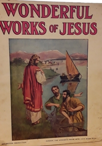
Book, The Epworth Press, Wonderful works of Jesus : his gracious deeds of kindness, Unknown
Tells various stories of the wonderful works of Jesus.Book with photograph on front cover of Jesus and his disciples in the sea of Galilee.fictionTells various stories of the wonderful works of Jesus.jesus christ, books, children's books -
 Mont De Lancey
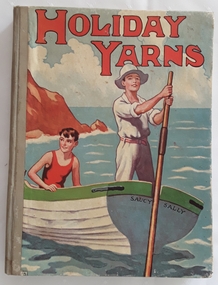
Book, Renwick of Otley, Holiday Yarns, early 1900's
This Book Belongs To Lance Sebire Dec 22nd Christmas 1934Hardcover children's book with a coloured picture of two boys rowing at sea in a boat called Saucy Sally on the front and back covers. The title Holiday Yarns is in large red lettering at the top on the front cover. There are black and white as well as some coloured illustrations.De Lancey Francis Sebire Christmas 1934 is written on the front right hand endpaper in grey pencil. Written inside on the page that says - This Book Belongs to - Lance Sebire Dec 22nd 1934children's fiction, adventure stories, young people's fiction -
 Mrs Aeneas Gunn Memorial Library
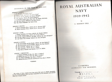
Book, Australian War Memorial, Royal Australian Navy 1939-1942, 1957
... Ocean and the seas to the north of Australia. The author ...This volume tells briefly the story of the Royal Australian Navy and of Australian naval policy between the wars, and then records the part played by the ships and men of that Navy on every ocean and particularly in the eastern Mediterranean and Indian and Pacific Oceans from 1939 until the end of the first quarter of 1942. When the volume ends most of the surviving ships are on the Australia Station again and the Japanese fleets dominate half the Pacific Ocean and the seas to the north of Australia. The author describes not only the actions of the Australian ships but the problems and policies of the British fleets of which they often formed a part, and discusses the strategical and administrative questions encountered by the senior leaders in AustraliaIndex, ill, maps, p.654.non-fictionThis volume tells briefly the story of the Royal Australian Navy and of Australian naval policy between the wars, and then records the part played by the ships and men of that Navy on every ocean and particularly in the eastern Mediterranean and Indian and Pacific Oceans from 1939 until the end of the first quarter of 1942. When the volume ends most of the surviving ships are on the Australia Station again and the Japanese fleets dominate half the Pacific Ocean and the seas to the north of Australia. The author describes not only the actions of the Australian ships but the problems and policies of the British fleets of which they often formed a part, and discusses the strategical and administrative questions encountered by the senior leaders in Australiaworld war 1939-1945 - australia, royal australian navy - history -
 Flagstaff Hill Maritime Museum and Village
Award - Medal, ca. 1872
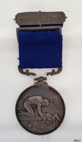
This medal is the Liverpool Shipwreck and Humane Society’s “Bramley-Moore medal for saving life at sea 1872”. The Society was formed in 1839. In 1872 Mr John Bramley-Moore donated £500 on condition that the medal have the specific inscription above on its reverse. The Bramley Morre medal was first awarded in 1874 and records show that since that time only one gold medal has been awarded, twenty-two silver medals and seventeen bronze medals, the last being in 1945. This Bromley-Moore medal was awarded to Peter Carmody for his bravery in saving lives on the Newfield shipwreck. The Newfield was a three-masted iron and steel barque, built in Dundee, Scotland, in 1889 by Alexander Stephen and Sons. It was owned by the Newfield Ship Company in 1890 and later that year It was registered in Liverpool to owners Brownells and Co. The Newfield left Sharpness, Scotland, on 28th May 1892 with a crew of 25 under the command of Captain George Scott and on 1st June left Liverpool. She was bound for Brisbane, Australia, with a cargo of 1850 tons of fine rock salt, the main export product of Sharpness. At about 9pm on 28th August 1892, in heavy weather, Captain Scott sighted, between heavy squalls, the Cape Otway light on the mainland of Victoria but, due to a navigational error (the ship’s chronometers were wrong), he assumed it to be the Cape Wickham light on King Island, some 40 miles south. He altered his course to the north, expecting to enter Bass Strait. The ship was now heading straight for the south west Victorian coast. At about 1:30am the Newfield ran aground on a reef about 100 yards from shore and one mile east of Curdie’s Inlet, Peterborough. The ship struck heavily three times before grounding on an inner shoal with 6 feet of water in the holds. Rough sea made the job of launching lifeboats very difficult. The first two lifeboats launched by the crew were smashed against the side of the ship and some men were crushed or swept away. The third lifeboat brought eight men to shore. It capsized when the crew tried to return it to the ship for further rescue The rescue was a difficult operation. The Port Campbell Rocket Crew arrived and fired four rocket lines, none of which connected with the ship. Peter Carmody, a local man, volunteered to swim about one mile off shore to the ship with a line to guide the fourth and final lifeboat safely to shore. He was assisted by James McKenzie and Gerard Irvine. Seventeen men survived the shipwreck but the captain and eight of his crew perished. The Newfield remained upright on the reef with sails set for a considerable time as the wind slowly ripped the canvas to shreds and the sea battered the hull to pieces. The Marine Board inquiry found the wreck was caused by a "one man style of navigation" and that the Captain had not heeded the advice of his crew. According to Jack Loney ‘… when the drama was over . . the Newfield was deserted except for the Captain’s dog and two pigs.’ Peter Carmody was awarded the Bramley-Moore medal by the Liverpool Shipwreck and Humane Society for Saving Life at Ssea, which he received by mail on January 21st 1893. The medal and a letter of congratulations were donated to Flagstaff Hill Maritime Museum by Peter Carmody’s grand-daughter Norma Bracken and her son Stuart Bracken on 25th May 2006. The Medal and Letter of Congratulations join other items in the Newfield collection.The Carmody Medal recognises the bravery of Peter Carmody in risking his life to rescue crew members of the Barque Newfield when it was wrecked near Curdies Inlet in August 1892. The ‘Bramley-Moore medal for saving life at sea, 1872’ was presented by the Liverpool Shipwreck and Humane Society. The medal and accompanying letter have local and international historic significance as they demonstrate both the difficulties associated with navigation and the dangers of shipping along the South West Coast of Victoria in the 19th century and the medal’s association with the Liverpool Shipwreck and Humane Society and John Bramley-Moore, who provided £500 to found the Bramley-Moore medal. The medal is socially significant. It emphasises the importance of Peter Carmody in rescuing victims of shipwrecks with little thought for his own safety. The medal reminds us of the importance of local people to Victoria’s maritime history. The Carmody Medal and Humane Society letter were in the Carmody family until they were presented to Flagstaff Hill Maritime Village, by the grand-daughter and great-grandson of Peter Carmody, on the 25th May 2006. The medal is significant for its complete provenance recorded in the donation documentation. The medal is in very good condition and relatively rare with only 22 silver medals awarded between 1874 and 1945. The Carmody Medal and letter add a human element to the story of the shipwrecks. They give life and significance to the Newfield, its victims and its artefacts. Bramley-Moore medal from the Liverpool Shipwreck and Humane Society, awarded to Peter Carmody. The round,silver medal is attached to a looped blue ribbon by a decorative, swivelling silver connector. The top of the ribbon has a silver pin bar threaded through it. The obverse of the medal has a design of a man kneeling on a floating part of a wreck. He is rescuing a child from the sea. There is a manned boat in the distance rescuing someone from the sea. In the far background there is a sailing ship. The top third of the medal has an inscription around it. The reverse shows a long-legged hen cormorant with extended wings holding an olive branch in its beak. The bird is surrounded by a wreath of oak leaves made from two branches. There is an inscription between the design and the rim that goes all the way around the circumference. There is a name engraved around the edge of the medal. The medal in embedded in a purple velvet panel that rests inside a brown, leather-covered case. The lid of the case has a gold embossed emblem in the cemtre. Both the lid and base have a rectangular gold border. The lid is attached to the base with two brass hinges. The base has a brass push-button catch. The box is lined with padded cream silk. The lining inside the lid has a gold emblem in the centre.The obverse has the words "LORD, SAVE US, WE PERISH". The reverse has the words "BRAMLEY-MOORE MEDAL FOR SAVING LIFE AT SEA" and "1872". Around the edge of the medal are the words "PETER CARMODY, FOR HAVING BEEN MAINLY INSTRUMENTAL IN RESCUING THE CREW OF THE BARQUE NEWFIELD, AUG 29 1892" The pin bar has the words “LIVERPOOL SHIPWRECK & HUMANE SOCIETY” written across it. The gold embossed emblem on the lid of the box has the words in the centre "SHIPWRECK AND …. …. ….FOUNDED 1839" The gold emblem on the cream silk lining has the words “BY APPOINTMENT ELKINGTON & CO” printed on it.medal, shipwrecked coast, flagstaff hill, flagstaff hill maritime museum, maritime museum, flagstaff hill maritime village, shipwreck coast, warrnambool, peter, peter carmody, carmody, bramley moore, newfield, liverpool shipwreck and humane society, 1892, 28 august 1892, august 1892, port campbell, bravery, shipwreck, rescue, nineteenth century, ship, curdie s river, victorian shipwrecks, barque, stuart bracken, norma bracken, gerard irvine, james mckenzie -
 Flagstaff Hill Maritime Museum and Village
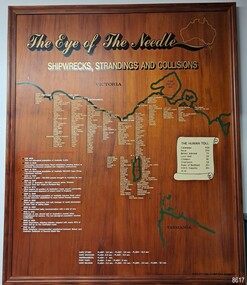
Artwork, other - Shipwreck Board, The Eye of the Needle: Shipwrecks, Stranding's and Collisions, ca 2002
The Shipwreck Board is a feature of Flagstaff Hill Maritime Museum and Village/ its subject is explained briefly in the Museum's handbook, The Flagstaff Hill Navigator, published in 2008: - "Known as the ‘Eye of the Needle’ the treacherous entrance to Bass Strait is littered with the wreckage of large international vessels and smaller sail and steam craft used in coastal trade. The vessels bringing emigrants and cargo to Australia found the western entrance to Bass Strait the most dangerous part of their voyage. They had to thread their way between the southern point of Victoria (Cape Otway) and the northern point of King Island, a stretch of water less than 90 km wide. Many smaller coastal vessels were lost at Portland, Port Fairy, Warrnambool and Apollo Bay which are not safe harbours in certain weather conditions. "The Shipwreck Board shows shipwrecks, strandings and collisions which occurred in this area up to the year 1940. Wrecks are identified by a yellow light and collisions/strandings by a green light. These lights also identify the decade the wreck occurred by lighting up when the relevant decade button is pushed. Interesting happenings of the decades are listed next to the buttons." The Shipwreck Board's demonstration of The Eye of the Needle is an interactive visual display that helps teach the perils and dangers faced by early settlers in Victoria. It tells of the vast number of lives lost. It lists the names of many infamous shipwrecks and significant events.The large stained and lacquered timber board is mounted in a timber, frame. It is painted with a small sketch of Australia, and an enlarged outline of the southern coast of Victoria, King Island and the North West coast of Tasmania. The interactive display highlights the shipwrecks, standings and collisions suffered by many vessels as they navigated the 'Eye of the Needle', a narrow stretch of Bass Strait. The locations of the Lighthouses are pinpointed. Lists of groups of ships are below the coastlines. A painted scroll shows eight major shipwrecks with the number of lives lost for each one. A table shows historical facts associated with the decades from pre-1830 to 1940. A system of coloured lights compares the decades with the vessels that suffered damage. The board was created by artist and signwriter, Alex O'Flynn Computer Signs.flagstaff hill, maritime museum, maritime village, shipwreck coast, eye of the needle, shipwreck locations, bass strait, basses strait, king island, north west tasmania, south coast of victoria, cape otway, victorian lighthouse, king island lighthouse, strandings, coastal tracers, emigrant ships, sea trade, 1930s-1940s, shipwreck board, the eye of the needle, collosions, alex o'flynn, alex o’flynn computer signs, shipwrecks of western victoria -
 Lakes Entrance Historical Society
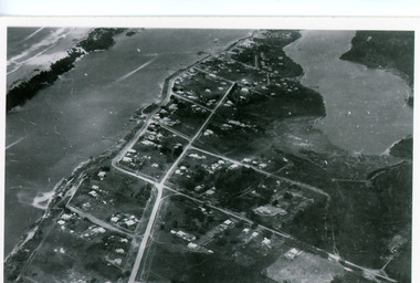
Photograph - Lakes Entrance, Bulmer H D, 1940c
Black and white photograph of aerial view of township. It shows route of Princes Highway through town, turning north at Myer Street and continuing along Roadknight Street. Few jetties on North Arm, many on Cunninghame Arm. In far upper left of image sea is breaking on sand hummocks. Lakes Entrance Victoriawaterways, township -
 Bendigo Historical Society Inc.
Document - MISS G ALICE JONES COLLECTION: ACCOUNT
Bendigo Amalgamated Gold Fields Ltd. To Miss G. Alice Jones. Re You V Geo Lakey - County court Summons £59.18.3. Scale C, Sale to Ennor. To Osgood, Land Tax, You V Brauman C. C. S. No. 27 (Special) Scale D £137.1.7, You V Brauman C.C.S. No. 38 (Ordinary), You V Brauman C.C.S. 1924 No. 43 (Special) £137.1.7., Clarence Freeholds-Sale to Bowden, Sea Co. Machinery & Freehold land, Land transferred from New Vic. Catherine Co., re Koch's Pioneer G.M. Co. N.L. transfer of G.M. Lease No 9791 Bendigo, re North Ulster G.M. Co. N.L. transfer of G.M Lease No. 9789 Bendigo. Details of costs and dates varying from June 28, 1923, to March 30, 1925.Also dated 3/6/25 and Pd 30/7/25.the miss g. alice jones collection - account, bendigo amalgamated goldfields ltd, geo lakey, mr stanfield, mr jn smalley, mr thomson, mr crow, mr ennor, osgood, mylon, mrs murdock, constable thomson, brauman, mr miller, melbourne sun, clarence freeholds, j h curnow & son, gazette, sea co, mr legge, mr skews, h m legge & co, new vic catherine co, koch's pioneer g m co nl, north ulster g m co nl, g m lease no 9789 bendigo -
 Lakes Entrance Historical Society
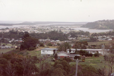
Photograph - Township, Fish, Marie, 1985c
\Colour photograph of township showing, North Arm and North Arm Bridge, Jemmys Point, Mount Barkly, Kalimna Heights on right, Cunninghame Arm and sand dunes on left. Looking towards Bullock Island and Rigby Island and Hopetoun Channel in centre background. Sea Vista flats in foreground. Photo take from near Telecom Tower on Merrangbaur Hill circa 1985. Lakes Entrance Victoria bridges, waterways, township -
 Lakes Entrance Historical Society
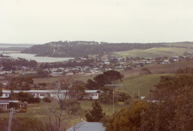
Photograph - Township, Fish, Marie, 1985c
Colour photograph of township showing, North Arm and North Arm Bridge, Jemmys Point, Mount Barkly, Kalimna Heights on right, Cunninghame Arm and sand dunes on left. Looking towards Bullock Island and Rigby Island and Hopetoun Channel in centre background. Sea Vista flats in foreground. Photo take from near Telecom Tower on Merrangbaur Hill circa 1985. Lakes Entrance Victoria bridges, waterways, township -
 Lakes Entrance Historical Society
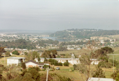
Photograph - Township, Fish, Marie, 1985c
Colour photograph of township, showing buildings, Jemmys Point, Mount Barkly, Kalimna Heights, North Arm and old North Arm bridge, and Rigby Island beyond. Sea Vista flats in foreground. Photo taken from near Telecom Tower on Merrangbaur Hill. Lakes Entrance Victoriatopography, township, waterways, bridges -
 Flagstaff Hill Maritime Museum and Village
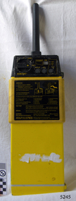
Equipment - EPIRB Transmitter
This distress EPIRB unit (Emergency Position Indication Radio Beacon) was found on the beach at Levy's Point, Warrnambool, in December 2000 by a Warrnambool resident. Local police were alerted at the time. This distress signal unit is a world-wide COSPAS/SARSAT, satellite assisted, SAR (Search and Rescue) system for location of distress transmissions emitted by an EPIRB. Offshore cruising vessels must have such a unit as part of its essential safety equipment. This model EPIRB relies on four satellites with orbit times of approximately 100 minutes. Earlier units relied solely on aircraft flying overhead to detect and forward on the EPIRB’s location to Search And Rescue authorities, whereas this new system utilises satellites. An employee from the Lokata firm provided additional information about the Lokata EPIRB units. They had a machined aluminium case with labels that were also made on site. The units could be activated manually or automatically released when a magnetic switch in the case casing was activated. This later model, circa 1983, would have been mounted externally on a vessel's bulkhead in a spring-loaded, stainless-steel protective 'skeleton' mounting, The unit released when the water pressure sensor detected a set time it was under the water, in a similar way that life crafts were released. Each unit was registered to a particular vessel - the vessel's details on this unit are indecipherable. The Lokata Company was established in 1970, designing and manufacturing marine products including communications. The company no longer makes products with the “Lokata” brand. In 2001 Sartech Engineering Ltd. took over the support for the Lokata EPIRB beacons. This emergency location device is a late 20th century invention to help save lives at sea. It adds to the history of maritime life, its risks, the lives lost as sea, and the many inventions aimed as rescuing and saving lives. The local area is notorious for the number of lives lost through shipwreck. It also carries stories of heroic efforts to save lives, and other inventions to help reduce the chance of accidents at sea.EPIRB unit; “Emergency Position Indication Radio Beacon”. A distress communication unit for sending a distress location transmission in an emergency at sea. The EPIRB is a yellow, rectangular box with dials, buttons, indicator lights and instruction. An antenna protrudes from the top of the unit. The EPIRB unit sends a 406P (X) EPIRB, with 406M-Hz frequency, 48-hour duration signal. The maker was LOKATA Ltd in England. Remnants of a white label remain on the side. Circa 1980s."NAME OF VESSEL 'SERVICE IF SELF TEST FAILS' " “LO-KATA” moulded into the body. "406P (X) EPIRB" “Model 406” "Lokata Type No 92408" "UK Type approved to MPT 1278" "Class 2" "Made by Lokata Ltd, Falmouth Cornwall England TR10 8AE"" "LOKATE LTD. New North Road Hainault, Ilford Essex IG6 2UR" "ARMED / SAFE / TRANSMIT / CODE / DISPLAY / SET / wait / pass / fail / TEST" "IDENTIFIER / 1349:24034234N" [some characters may be different] "COUNTRY / DENMARK" "VESSEL IDENTITY / 124 [the rest is indecipherable]flagstaff hill, warrnambool, shipwrecked-coast, flagstaff-hill, flagstaff-hill-maritime-museum, maritime-museum, shipwreck-coast, flagstaff-hill-maritime-village, emergency position indicating radio beacon, epirb, lokata ltd, marine safety equipment, satellite transmitting beacon, safety equipment, distress signal, life saving, safety at sea, shipwreck location, lo-kata, falmouth, emergency, beacon, radio signal, communication, marine equipment -
 National Vietnam Veterans Museum (NVVM)
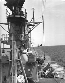
Photograph, Gibbons, Denis, HMAS Hobart 1
Denis Gibbons (1937 – 2011) Trained with the Australian Army, before travelling to Vietnam in January 1966, Denis stayed with the 1st Australian Task Force in Nui Dat working as a photographer. For almost five years Gibbons toured with nine Australian infantry battalions, posting compelling war images from within many combat zones before being flown out in late November 1970 after sustaining injuries. The images held within the National Vietnam Veterans Museum make up the Gibbons Collection.A black and white photograph of the destroyer HMAS Hobart under the command of Captain Guy Griffiths with American destroyers attached as a flotilla, sailing in line as they engage North Vietnam shore batteries and SAM missile sites while on the 'Gun Line' of 'Operation Sea Dragon'.photograph, hmas hobart, tonkin gulf, 7th fleet, operation sea dragon, gibbons collection catalogue, photographer, vietnam war, denis gibbons, gun line, capt guy griffiths, american destroyers -
 National Vietnam Veterans Museum (NVVM)
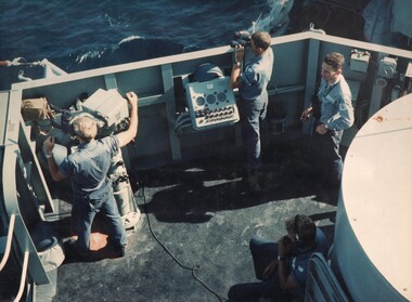
Photograph, Gibbons, Denis, HMAS Hobart 2
Denis Gibbons (1937 – 2011) Trained with the Australian Army, before travelling to Vietnam in January 1966, Denis stayed with the 1st Australian Task Force in Nui Dat working as a photographer. For almost five years Gibbons toured with nine Australian infantry battalions, posting compelling war images from within many combat zones before being flown out in late November 1970 after sustaining injuries. The images held within the National Vietnam Veterans Museum make up the Gibbons Collection. A colour photograph crew members of HMAS Hobart under the command of Captain Guy Griffiths search the horizon on operations on the gun line in the Tonkin Gulf. HMAS Hobart was renowned for the accuracy of its gunfire when engaging North Vietnamese shore batteries and SAM missile sites during Operation Sea Dragon.photograph, hmas hobart, tonkin gulf, capt guy griffiths, operation sea dragon, gibbons collection catalogue, 7th fleet, denis gibbons, photographer, vietnam war, crew members, north vietnamese, sam missiles -
 Bendigo Historical Society Inc.
Document - BENDIGO MINES 1906
Handwritten notes mentioning Bendigo Mines. Four mines, Garden Gully United, South New Moon, Hustlers Reef and Catherine Reef United have some information about them. Others listed are: Catherine Reef United, Carlisle, Clarence United, Central Ellesmere, Collman & Tacchi, Confidence Extended Cornish United, Ellenborough, Extd South Devonshire, Eureka, Fortuna Hustlers, Garden Gully United, G G Consolidated, Geribaldi, Great Southern, Gt Northern, Gt Extended Hustlers, Gt Central Victoria, Golden Age, Golden Pyke, Goldfields North, Goldfields Consolidated, North Johnsons, Pearl, Princess Dagmar, Phoenix, Railway Prince of Wales, Shamrock, St Mungo, Sadowa, Sea, Specimen Hill Sth St Mungo, South New Moon, South Devonshire, Suffolk United, United Devonshire, Unity, United Hustlers & Redan, United Ulster, Victoria Consols, Victoria Quartz, Pansora, Virginia, Victoria Proprietory, Williams United, Hustlers Reef, Hustlers Royal Reserve, Hercules & Energetic, Ironbark, Johnsons Reef No 1, Hustlers Royal Reserve, Ironbark, Johnsons Reef, Johnsons Extended, Kochs Pioneer, Lazarus New Chum, Lady Barkly - Lightning Hill, McDuff Amalgamated, Morning Star, New Chum Consolidated, New Chum Railway, New Chum & Victoria, New Blue Consolidated, New Hopefu, New St Mungo, New Argus, New Moon, New Victoria Catherine, New Chum Goldfields, North New Moon and North Argus. Document from Albert Richardson Collection of mining history.document, gold, bendigo mines 1906, bendigo mines 1906, catherine reef united, carlisle, clarence united, central ellesmere, collman & tacchi, confidence extended cornish united, ellenborough, extd south devonshire, eureka, fortuna hustlers, garden gully united, g g consolidated, geribaldi, great southern, gt northern, gt extended hustlers, gt central victoria, golden age, golden pyke, goldfields north, goldfields consolidated, north johnsons, pearl, princess dagmar, phoenix, railway prince of wales, shamrock, st mungo, sadowa, sea, specimen hill sth st mungo, south new moon, south devonshire, suffolk united, united devonshire, unity, united hustlers & redan, united ulster, victoria consols, victoria quartz, pansora, virginia, victoria proprietory, williams united, hustlers reef, hustlers royal reserve, hercules & energetic, ironbark, johnsons reef no 1, hustlers royal reserve, ironbark, johnsons reef, johnsons extended, kochs pioneer, lazarus new chum, lady barkly - lightning hill, mcduff amalgamated, morning star, new chum consolidated, new chum railway, new chum & victoria, new blue consolidated, new hopefu, new st mungo, new argus, new moon, new victoria catherine, new chum goldfields, north new moon, north argus, bgo library 'healthy golden bendigo' - 1906 -
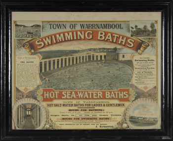 Warrnambool and District Historical Society Inc.
Photograph - Framed photograph of Warrnambool Salt Water Baths, c. 1920
This is a framed photograph of the men's pool at the Warrnambool Salt Water Baths. These Baths were originally built at the end of Gilles Street on the line of the present railway line in 1876 but were rebuilt in 1889 further north in Gilles Street when the railway line was opened. The water was pumped from the sea, initially by a windmill and later by a gas pump. The men's pool was 100 feet by 50 feet and the women's pool was 60 feet by 30 feet with bathing strictly segregated in the 19th century. A building nearby housed marble cubicles with hot spa baths with the water heated on the site and a caretaker's cottage completed the complex. Men's nude bathing was a feature of the early 20th century. Originally built by a local public company the Baths were taken over by the Warrnambool Council. These baths were superseded by the opening in 1961 of an Olympic Pool In Warrnambool. The site and the remaining buildings of the old sea water baths are now heritage-listed and today form part of the headquarters of the Warrnambool and District Historical Society.This photograph is of historical significance as a depiction of the Warrnambool Salt water Baths in the early 20th century. These Baths were the basis for promoting Warrnambool as a health and spa resort town in the late 19th and early 20th centuries.This is a framed black and white photograph of the men's pool at the Warrnambool Salt Water Baths. It depicts men and boys swimming in the circular pool and one male on the diving board. All these men are naked. There are other clothed males and clothed attendants wearing hats and waistcoats. The change rooms are on the right side of the photograph and there is a fence with trees behind. The photograph is mounted on cardboard with a gilt edge and is held in a wooden ridged frame behind glass. warrnambool sea water baths, sea baths, warrnambool pool, gilles street