Showing 25290 items
matching north-coombes
-
 Eltham District Historical Society Inc
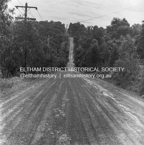
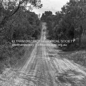
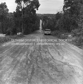
Photograph, Michael Wood, Progress Road looking west towards intersection with Ryans Road, Eltham North, 1976, 1976
Progress Road between Ryans Road and Lower Road, Eltham North; prior to realignment and construction, 1976Kodak Safety Film 120 format 6 x 6 cm black and white negative; 3 strips, 12 frameseltham north, ryans road, progress road, road construction -
 Eltham District Historical Society Inc
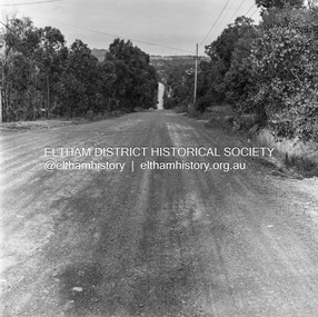
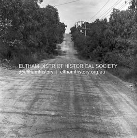
Photograph, Michael Wood, Progress Road looking east from outside No. 180, Eltham North, 1976, 1976
Progress Road between Ryans Road and Lower Road, Eltham North; prior to realignment and construction, 1976Kodak Safety Film 120 format 6 x 6 cm black and white negative; 3 strips, 12 frames Also 30 x 25 cm black and white print of this image frameeltham north, progress road, road construction -
 Eltham District Historical Society Inc
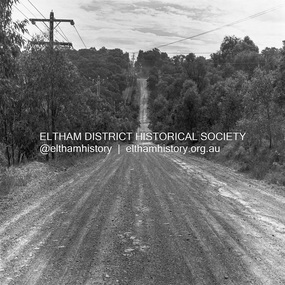
Photograph, Michael Wood, Progress Road looking west towards intersection with Ryans Road, Eltham North, 1976, 1976
Progress Road between Ryans Road and Lower Road, Eltham North; prior to realignment and construction, 1976Kodak Safety Film 120 format 6 x 6 cm black and white negative; 3 strips, 12 frames Also 30 x 25 cm black and white print of this image frameeltham north, progress road, road construction -
 Eltham District Historical Society Inc
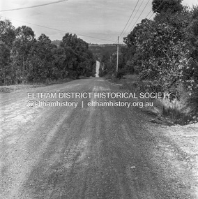
Photograph, Michael Wood, Progress Road looking east from outside No. 180, Eltham North, 1976, 1976
Progress Road between Ryans Road and Lower Road, Eltham North; prior to realignment and construction, 1976Kodak Safety Film 120 format 6 x 6 cm black and white negative; 3 strips, 12 frameseltham north, progress road, road construction -
 Eltham District Historical Society Inc
Photograph, Michael Wood, Progress Road looking west towards intersection with Ryans Road, Eltham North, 1976, 1976
Progress Road between Ryans Road and Lower Road, Eltham North; prior to realignment and construction, 1976Kodak Safety Film 120 format 6 x 6 cm black and white negative; 3 strips, 12 frames Also 30 x 25 cm black and white print of this image frameeltham north, progress road, road construction, ryans road -
 Eltham District Historical Society Inc
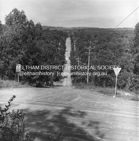
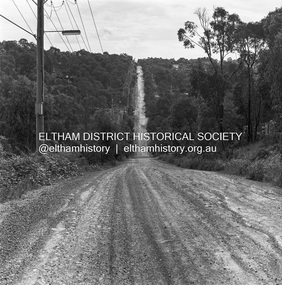
Photograph, Michael Wood, Progress Road looking east from Ryans Road, Eltham North, 1976, 1976
Progress Road between Ryans Road and Lower Road, Eltham North; prior to realignment and construction, 1976Kodak Safety Film 120 format 6 x 6 cm black and white negative; 3 strips, 12 frames Also 30 x 25 cm black and white print of this image frameeltham north, progress road, road construction, ryans road -
 Eltham District Historical Society Inc
Photograph, Michael Wood, Progress Road looking west towards intersection with Ryans Road, Eltham North, 1976, 1976
Progress Road between Ryans Road and Lower Road, Eltham North; prior to realignment and construction, 1976Kodak Safety Film 120 format 6 x 6 cm black and white negative; 3 strips, 12 frames Also 30 x 25 cm black and white print of this image frameeltham north, progress road, road construction, ryans road -
 Eltham District Historical Society Inc
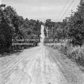
Photograph, Michael Wood, Progress Road looking east from near Ryans Road, Eltham North, 1976, 1976
Progress Road between Ryans Road and Lower Road, Eltham North; prior to realignment and construction, 1976Kodak Safety Film 120 format 6 x 6 cm black and white negative; 3 strips, 12 frames Also 30 x 25 cm black and white print of this image frameeltham north, progress road, road construction, ryans road -
 Eltham District Historical Society Inc
Photograph, Michael Wood, Progress Road looking east from outside No. 180, Eltham North, 1976, 1976
Progress Road between Ryans Road and Lower Road, Eltham North; prior to realignment and construction, 1976Kodak Safety Film 120 format 6 x 6 cm black and white negative; 3 strips, 12 frames Also 30 x 25 cm black and white print of this image frameeltham north, progress road, road construction -
 Eltham District Historical Society Inc
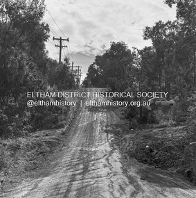
Photograph, Michael Wood, Progress Road looking west from Lower Road, Eltham North, 1976, 1976
Progress Road between Ryans Road and Lower Road, Eltham North; prior to realignment and construction, 1976Kodak Safety Film 120 format 6 x 6 cm black and white negative; 3 strips, 12 frames Also 30 x 25 cm black and white print of this image frameeltham north, progress road, road construction, lower road -
 Eltham District Historical Society Inc
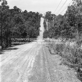
Photograph, Michael Wood, Progress Road looking east from near outside No. 196, Eltham North, 1976, 1976
Progress Road between Ryans Road and Lower Road, Eltham North; prior to realignment and construction, 1976Kodak Safety Film 120 format 6 x 6 cm black and white negative; 1 strips, 2 frameseltham north, progress road, road construction -
 Eltham District Historical Society Inc
Photograph, Michael Wood, Progress Road looking east from near outside No. 196, Eltham North, 1976, 1976
Progress Road between Ryans Road and Lower Road, Eltham North; prior to realignment and construction, 1976Kodak Safety Film 120 format 6 x 6 cm black and white negative; 1 strips, 2 frameseltham north, progress road, road construction -
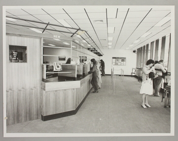 Ringwood and District Historical Society
Photograph, Interior of Ringwood North State Bank , south-east corner of Dickson's Cresent and Warrandyte Road
The new Ringwood North State Bank premises on the south-east corner of Dickson's Cresent. Showing customer service area. Opened 23 August 1982At the corner of Dickson's Cresent and Warrandyte Road, Ringwood North. Photographer - Les Gorrie Photography, 28 Waldemar Road, Heidelberg. Negative #82334 -
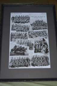 Wangaratta RSL Sub Branch
Framed newspaper article, Boys from the North at Torquay Camp, 16 March 1940
1940 newspaper article showing collage of photographs of soldiers from Victorian north east towns whilst at Army training camp in Torquay during World War Two.Photographs depicting soldiers who enlisted from towns in Victoria's north east whilst at training camp in Torquay prior to deployment during World War Two.Black patterned plastic frame with dark grey mount over newspaper article depicting 10 photographs of soldiersWeeklyTimes, March 16, 1940 Boys from the North at Torquay Campyarrawonga, corryong, walwa, myrtleford, moyhu, wangaratta, tallangatta, wahgunyah, tungamah, st james, wodonga -
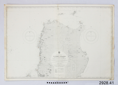 Flagstaff Hill Maritime Museum and Village
Document - Navigation Chart, Luzon Island : North of Latitude 16º 20' North
British Admiralty Navigation Chart - Luzon Island : North of Latitude 16º 20' Northwarrnambool, shipwrecked-coast, flagstaff-hill, flagstaff-hill-maritime-museum, maritime-museum, shipwreck-coast, flagstaff-hill-maritime-village, shipwrecked-artefact, navigation chart, british admiralty navigation chart, british admiralty, luzon island -
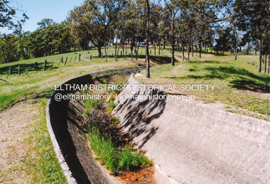
 Eltham District Historical Society Inc
Photograph, Maroondah Aqueduct north of Allendale Road, Eltham North
Four colour photographs of abandoned Maroondah Aqueduct north of Allendale Road, Eltham Northaqueducts, maroondah aqueduct, allendale road, eltham north -
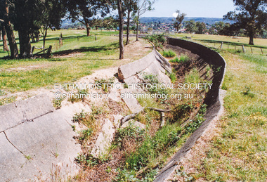
 Eltham District Historical Society Inc
Photograph, Maroondah Aqueduct north of Allendale Road, Eltham North
Four colour photographs of abandoned Maroondah Aqueduct north of Allendale Road, Eltham Northaqueducts, maroondah aqueduct, allendale road, eltham north -
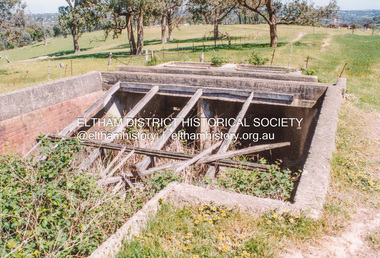
 Eltham District Historical Society Inc
Photograph, Maroondah Aqueduct north of Allendale Road, Eltham North
Four colour photographs of abandoned Maroondah Aqueduct north of Allendale Road, Eltham Northaqueducts, maroondah aqueduct, allendale road, eltham north -
 Eltham District Historical Society Inc
Photograph, Maroondah Aqueduct north of Allendale Road, Eltham North
Four colour photographs of abandoned Maroondah Aqueduct north of Allendale Road, Eltham Northaqueducts, maroondah aqueduct, allendale road, eltham north -
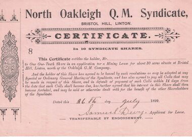 Linton and District Historical Society Inc
Share certificate, Berry Anderson & Co., Ballarat, North Oakleigh Q.M. Syndicate, Bristol Hill, Linton, 1899, 1899
Found in the loft of Bank of NSW 1980s.Beige-coloured certificate with decorative border printed on left hand side. Stamped number 8. Serrated left edge of certificate suggests it was detached from a booklet or form. Entitles the holder to one-tenth share in an application for a mining lease at Bristol Hill, Linton ("north of the Oakleigh G.M. Company"). Certificate is not made out to any person, but is signed "Samuel Devy, Applicant for Lease" and dated 26 July 1899.Text: " North Oakleigh Q.M. Syndicate, / BRISTOL HILL, LINTON. "bristol hill, north oakleigh mine, samuel devy, gold mining, mining share certificates, mining leases -
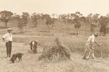 Ringwood and District Historical Society
Photograph, Harvesting at Quamby, North Ringwood on farm of A.T. Miles 1915
Black and white photograph of men working in paddock. There are two smaller sepia original photographs slipped into protective sheet. On the back of each of these photographs the following is stated, "Harvesting at 'Quamby', Quamby Rd. North Ringwood 1910. L to R Miles, Herman Johansen & Henry James".Backing sheet states, "Harvesting at Quamby, North Ringwood on farm of A. T. Miles (on left) 1915. -
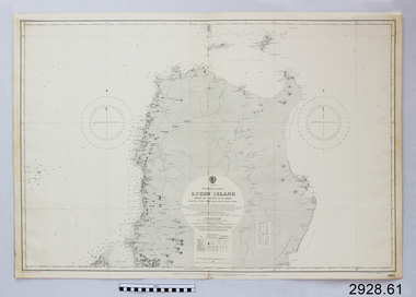 Flagstaff Hill Maritime Museum and Village
Document - Navigation Chart, Luzon Island, North of Latitude 16° 20' north
British Admiralty Navigation Chart - Phillippine Islands - Luzon Island, North of Latitude 16° 20' northwarrnambool, shipwrecked-coast, flagstaff-hill, flagstaff-hill-maritime-museum, maritime-museum, shipwreck-coast, flagstaff-hill-maritime-village, shipwrecked-artefact, navigation chart, british admiralty navigation chart, british admiralty, luzon island -
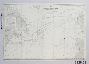 Flagstaff Hill Maritime Museum and Village
Document - Navigation Chart, North Atlantic : Route Chart showing Lane Routes North of Ireland
British Admiralty Navigation Chart - North Atlantic : Route Chart showing Lane Routes North of Irelandwarrnambool, shipwrecked-coast, flagstaff-hill, flagstaff-hill-maritime-museum, maritime-museum, shipwreck-coast, flagstaff-hill-maritime-village, shipwrecked-artefact, navigation chart, british admiralty navigation chart, british admiralty, north atlantic, route chart -
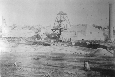 Stawell Historical Society Inc
Photograph, North Cross Reef Mine & Mining Scene 1870 -- B/W Photo & Coloured Painting
Mining Scene - North Cross Reef Co.B/W North Cross Reef with buildings, poppet heads, Tailings and wood stack with people. Two colour prints of North cross Reef. One at a different angle to B/W. Second taken further back with wood stacks, tailing dam fenced in beyond poppet heads buildings chimmney's smoking. stawell -
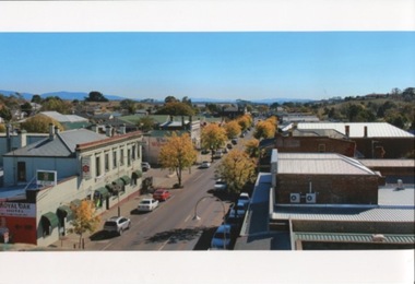 Kilmore Historical Society
Photograph, Sydney Street 180 North, 05/2015
30cm x 20cm coloured photograph from the top of the Old Town Hall looking North. It shows the Royal Oak and many cars parked on the street.Written on the back: May 2015 From top of Old Town Hall looking north Photo Simon Marshall Photo by Simon Marshall Construction + Building Design -
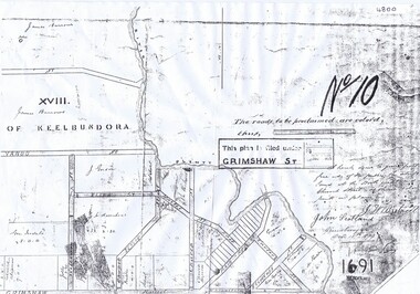 Greensborough Historical Society
Plan, Parish Plan Map of Land North of Grimshaw Street, 11/12/1879
Part of Parish plan of land north of Grimshaw Street bounded by the Plenty River. Includes annotation signed by John Scotland and J. W. Britnell, dated Dec. 11th 1879.Photocopy of part of Parish plan of land north of Grimshaw Street bounded by the Plenty River. Includes annotation signed by John Scotland and J. W. Britnell, dated Dec. 11th 1879greensborough, grimshaw street greensborough, jonah britnell, john scotland -
 Friends of Ballarat Botanical Gardens History Group
Photograph - First residence of George Longley and family in the Ballarat Botanical Gardens, North Lodge, George Longley residence, 1863-1867, 1st Curator of the Ballarat Botanical Gardens, C 1863-1867
First curator's cottage, was built in the gardens early 1860's, later moved to 1414 Gregory St, now relocated back to the Northern Gardens and used by the "Friends of the Ballarat Botanical Gardens" for meetings and Botanikids activities.The Cottage is important as an early structure in the Ballarat Botanical Gardens. It is one of the early works of the Ballarat pioneer architect, Cassini. Its removal from Gregory Street back to the Gardens is testament to the generosity and enthusiasm of the Friends of the Ballarat Botanical Gardens. Its renovation was funded by the Ballarat City Council and the Friends of the Botanic Gardens as an important landmark from the past. It is now visited, used and enjoyed by the community. Many original features of the Cottage are intact with a modern extension.Blurred photograph in parts especially lower half of the photograph.Back of black and white photograph in biro, longhand print, "North Lodge - Geo.Longley First Curator- Residence. From 1863 to 1867 Gardens Cottage Built." Now located at 1414 Gregory Street. In faint print, THORNTON RICHARDjohn garner collection, garner, dr, george longley, longley, curator, curator house, ballarat botanical gardens, ballarat, gardens, north lodge, cassini, architect, northern gardens, longley family -
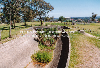
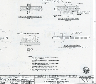 Ringwood and District Historical Society
Plan - plans, Metropolitan board of Works, Metropolitan Board of Works plans of North Ringwood retarding basin, energy dissipaters and spillway details, 1979, 31-May-79
Plans made by the Metropolitan Board of Works in May 1979 detailing 1. energy dissipaters for existing drains at the North Ringwood Retarding basin. 2 spillway details2 A3 pages with drawings of Melbourne Metropolitan Board of Works of the North Ringwood retarding basin -
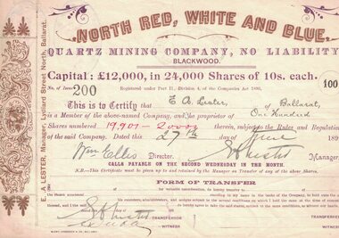 Linton and District Historical Society Inc
Share certificate, BERRY ANDERSON, North Red, White and Blue Quartz Mining Company, Blackwood, 1899, 1899
Found in the loft of Linton Bank of NSW in 1980s.Certificate for North Red, White and Blue Quartz Mining Company, No Liability, Blackwood. One hundred shares in the name of E.A. Lester, of Ballarat.Text: " NORTH RED, WHITE AND BLUE, / QUARTZ MINING COMPANY, NO LIABILITY, / BLACKWOOD. " "E A Lester Ballarat - One hundred - 19907-2000- 27th June - WM Ellis - E A Lester - Deeble".north red white and blue quartz mining company, blackwood, e.a. lester, william ellis, g. deeble -
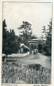 Mt Dandenong & District Historical Society Inc.
Photograph, Mt Dandenong North. Showing "Mountjoy"
The building with the white picket fence is the Beulah Tea Gardens opened by Eliza Hand c1904 at The Gap (now FiveWays). The building is still operating as a cafe. The Tourist Road does not yet exist. Old Coach Road comes into the picture from the right and the horse and cart is heading up Ridge Road. The elm trees can be seen on the left. The building up on the hill is the Mountjoy Guest House. ‘Mountjoy’ was built by the Paynter family in 1905. It had fourteen bedrooms, a dining room and sitting room, kitchen with a big wood burning range and verandahs on three sides. There were commanding views of the eastern ranges and the city to the west. Ellis Jeeves purchased ‘Mountjoy’ in 1908 and it soon became a popular tourist destination, the coach yards making it a centre of the district. ‘Mountjoy’ is a central feature of many photographs of Kalorama in the 1900s. The building burned down in 1975. Mt. Dandenong North was renamed Kalorama c1932.Black and white postcard showing a horse and cart on road between two buildings.On front ; Mt. Dandenong North. Showing "Mountjoy."postcard, mountjoy, guest house, beulah tea room, beulah, mt dandenong north, kalorama