Showing 24119 items matching "ocean"
-
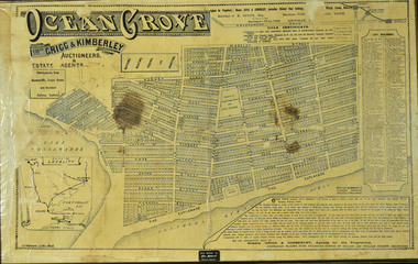 City of Greater Geelong
Paper on Board, Framed Land Sale Poster, Ocean Grove
-
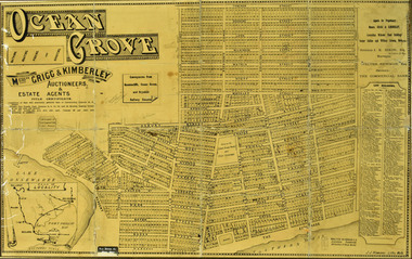
 City of Greater Geelong
Paper on Board, Framed Town Plan, Ocean Grove
-
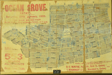
 City of Greater Geelong
Paper on Board, Framed Sale Plan, Ocean Grove
-
 Thompson's Foundry Band Inc. (Castlemaine)
Sheet Music, Dreams On The Ocean
-
Moorabbin Air Museum
Book - Quantas Empire Airways (Western Operations Division) Indian Ocean Service 1943-1946, Barry Pattison et al
This book covers the story of the air route from Australia to India across the Indian ocean that was established after traditional methods of communication and transport had been cut with the fall of Singapore.Tan cover with black text and a monochrome photo of a docked sea plane.This book covers the story of the air route from Australia to India across the Indian ocean that was established after traditional methods of communication and transport had been cut with the fall of Singapore.ww2, qantas -
 Federation University Historical Collection
Book, Geological Gossip or Stray Chapters on Earth and Ocean, 1860, 1860
Brown hard covered book. Chapter 16 is on gold deposits and discusses the discovery of gold in California and Australia.Brown hard covered book geology, water, rivers, the atlantic, great deep, africa, australian interior, eyre's expedition, murray river, darling river, earthqaukes, leichardt, moreton bay, volcanos, darwin's theory, evolution, egyptian race, human remains in caverns and gravel, rocks, metamorphism, iron ores, coal, coal fields, gold deposits, california, water-glass, artificial stone, porous stones, cements -
Lakes Entrance Historical Society
Book, Loney Jack, Wrecks Along the Great Ocean Road, 1967
Account of many of the shipwrecks which occurred on the west coast of Victoria from 1839 to 1964. Some information on lighthouses, rocket crews,and cliff rescue squads. Index of ships, glossary of rigging terms.maritime history -
Lakes Entrance Historical Society
Book, Clark, Vincent and Anderson Tsari, Ocean Access Boat Ramp Bastion Point Mallacoota, 2005
Cultural Heritage Investigation. Report to East Gippsland Shire Council. Cultural Heritage Investigation.waterways, township -
Moorabbin Air Museum
Book - RESCUE IN THE SOUTHERN OCEAN, Penguin Books Australia Ltd, 1997
-
 Port Fairy Historical Society Museum and Archives
Photograph
South Beach Port FairyEarly view of South Beach Wave breaking over rocks at South Beachbeach, sea, seascape, ocean, waves -
Glenelg Shire Council Cultural Collection
Photograph - Photograph, framed collection - Early harbour facilities in Portland, n.d
UnknownFramed collection of black and white photographs in brown timber frame, under glass. 1. Lighthouse and staff building - Battery point; 2. Official opening - Ocean Pier; 3. Official opening - Ocean Pier, cutting the ribbon; 4. Henty's House (101 Bentick St); 5. Lighthouse - Battery Point; 6. Lighthouse quarters, Battery Point; 7. View from London Hotel of Henty Piers; 8. Portland early 1860s from Whalers Point; 9 & 10. First piles being driven for the ocean pier.Front: Lighthouse and staff building - Battery point/ Official opening - Ocean Pier/ Official opening - Ocean Pier, cutting the ribbon/ Henty's House (101 Bentick St)/ Lighthouse - Battery Point/ Lighthouse quarters, Battery Point/ View from London Hotel of Henty Piers/ Portland early 1860s from Whalers Point/ First piles being driven for the ocean pier. Back: (no inscriptions)port of portland -
Glenelg Shire Council Cultural Collection
Artwork, other - Engraving, Turning the First Furrow in Victoria, 1887
Black and white etching showing 6 bullocks, 1 dog, 1 ploughman. Ploughman is holding the plough. 1 Man holding whip on clifftop overlooking ocean. Frame - Golden timber/mottled. Inner mount - Gold.Front: Panorama of Portland, Victoria (length of Ocean Pier 2880 ft).etching, portland, plough, rural, farming -
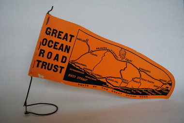 Anglesea and District Historical Society
Pennant, Unknown
Orange pennant flag listing towns on and near the Great Ocean Road. List of town names on pennant - (west to east) Mortlake, Warrnambool, Nirranda, Terang, Port Campbell, Lavers Hill, Colac, Beech Forest, Apollo Bay, Wye, Birregurra, Forrest, Deans Marsh, Peterborough, Princetown, Lorne, Eastern View, Airy's Inlet, Anglesea, Torquay, Geelong, Barwon Heads.GREAT/ OCEAN/ ROAD/ TRUST. Map of Area/ Route of the Great Ocean. (Orange - on wire stand. Printed on both sides.) great ocean road trust -
 Flagstaff Hill Maritime Museum and Village
Photograph - Historical, Flagstaff Hill, John Lindsay, View of the Bay from the south boundary of the Ports and Harbours land, 1970s
The photograph shows the view of the shore and Lady Bay with the Breakwater and Middle Island all visible. It was taken to show that the Flagstaff Hill area was unlikely to have any further development between it and the Bay, with the view of development of the Flagstaff Hill Maritime Museum and Village. This photograph, a print, is one of a set of five that show the site of Flagstaff Hill. The photographer was John Lindsay, Founding Director of Flagstaff Hill Maritime Museum and Village, with the words "Photo J Lindsay" on the back. It was taken in the early 1970s during the initial stages of the development of Flagstaff Hill as a Museum and Maritime Village. The photographs belonged to the donor's grandparents, who lived in the Warrnambool district of Allansford/Naringal. The photograph is a record of the site and surrounds of Flagstaff Hill Maritime Museum and Village before its development and opening in 1975. It shows the Surfside Holiday Park, Surf Lifesaving Club, and the Breakwater. The photograph is significant for recording the location and condition of the Lower Lighthouse on the Hill.Coloured photograph, glassy print, one of a set of five. Flagstaff Hill's Lower Lighthouse is in the foreground above the Surfside Holiday Park. To the right of centre is the Surf Lifesaving Club. In the background is Lady Bay and the Breakwater and Middle Island, with the Southern Ocean the other side. The photograph's paper has the printer's watermark and a pencilled inscription on the back. The early 1970s scene was photographed by John Lindsay, Warrnambool.Label on the back: "VIEW OF THE BAY FROM the southern boundary of the Ports and Harbours land. No development below this area is likely to obstruct the view, due to the steep grade down to the Southern boundary of Flagstaff Hill property." Handwritten in pencil: "Photo J Lindsay"flagstaff hill, flagstaff hill maritime museum and village, warrnambool, maritime museum, maritime village, great ocean road, shipwreck coast, 1970s, photograph, surfside holiday park, lady bay, flagstaff hill site, john lindsay, lower lighthouse, lower light, surf lifesaving club, breakwater, middle island, ports and harbours -
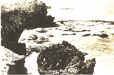 Port Fairy Historical Society Museum and Archives
Postcard, "The Crags", c. 1930
The crags- Circa 1930Photograph Rocky area with ocean waves washing over The crags Port Fairy the crags, rocks, sea, ocean, princes highway -
Glenelg Shire Council Cultural Collection
Functional object - Seal, Port of Portland Authority Seal, 1980s
Used by Port of Portland Authority for sealing of documents between 1982-1997.256.1: Positive section (metal) of Port of Portland Authority seal. Logo and text at top and bottom plates. Port of Portland Authority (around outside) [image of lighthouse, cliff, anchor and ocean] (centre) 256.2: Negative section (bronze) of Port of Portland Authority seal. Logo and text at top and bottom plates. Port of Portland Authority (around outside) [image of lighthouse, cliff, anchor and ocean] (centre)Front: Port of Portland Authority * (around outside) [image of lighthouse, cliff, anchor and ocean] (centre) Back: - -
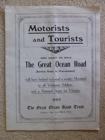 Warrnambool and District Historical Society Inc.
Leaflet, Motorists and Tourists
This leaflet published by The Great Ocean Road Trust in 1918 gives information about the proposed building of the Great Ocean Road from Barwon Heads to Warrnambool as a memorial to Victorian soldiers in World War One. The President of the Trust, which was a private company seeking donations from the public, was Howard Hitchcock, the Mayor of Geelong. The Memorial Great Ocean Road commenced in 1919 with 3000 ex-servicemen employed to build the road. In 1932 the road was completed to Apollo Bay and in 1936 the road was officially handed into the care of the State Government. This leaflet is of some significance as it shows the initial efforts by Howard Hitchcock of Geelong and a private trust to build the Great Ocean Road in Victoria. This road is today of international significance This is an unbound leaflet of 8 pages (almost A4 size) folded into two insert pages. It has 10 photographs of views along the Great Ocean Road and typed information on the Great Ocean Road Trust and its Building Appeal. It was produced in 1918.great ocean road, great ocean road trust 1918, warrnambool history, memorial great ocean road -
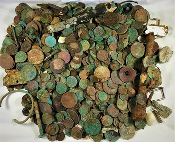 Queenscliffe Maritime Museum
Coin - Assorted coin and other objects retrieved from the ocean floor
Coin and other metal objects retrieved from the ocean floorMultiple coin and other metal objects collected by a diver from local waters.A collection of various coin and other metal objects retrieved from the ocean floor showing corrosion and encrustation.salvage, diving, ship relics -
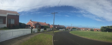 Ballarat Heritage Services
Photograph - Colour, Clare Gervasoni, Wattle Grove, Warrnambool, 2017, 11/02/2017
The Ocean and Wattle Groves Precinct, Warrnambool is registered by Heritage Victoria, and is one of the earliest rural Housing Commission estates in Victoria. It is an intact, representative example of mid-twentieth century public housing in Victoria. It is of special historical significance for the Commission’s connection with the Warrnambool-born Walter Oswald Burt, one of the two key figures behind the slum-abolition movement and a founder of the building conservation movement.Colour panoramic photograph of houses in Wattle Grove, Warrnambool.walter burt, walter oswald burt, warrnambool, ocean grove, wattle grove, housing commission -
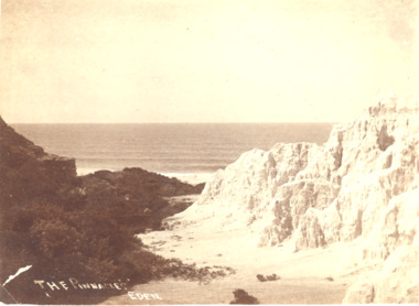 Lakes Entrance Historical Society
Photograph, A Davis Eden, Pinnacles Eden N.S.W, 1940 c
Sepia toned photograph showing a view of the ocean from the spectacular cliffs known as the Pinnacles Eden N.S.W.The Pinnacles Edencoast, ocean, topography -
 Lakes Entrance Historical Society
Photograph - The Entrance, Bulmer H D, 1935
Black and white photograph of the entrance, shows entrance channel east and west piers, ocean surf breaking on sandy beach. Lakes Entrance Victoriapiers, ocean -
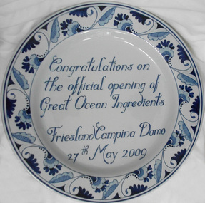 Cheese World Museum
Plate, 2009
The plate was presented to WCB on the occasion of the official opening of the joint project Great Ocean Ingredients.Large blue and white porcelain plate with a floral border and finished with a fine blue line around the rim. An inscription sits in the centre of the plate. The base has three fine lines around the rim and two holes on the rim to hang the plate.Congratulations on the official opening of Great Ocean Ingredients Friesland Campina Dorno 27th May 2009allansford, warrnambool cheese & butter factory company ltd, great ocean ingredients, trophies, presentations, awards, friesland, porcelain -
 Ballarat Heritage Services
Photograph - digital photographs, Lisa Gervasoni, Sorrento Pre Olympic Pool, c2010-2017
Colour photograph of the ocean swimming pool at Sorrento. swimming pool, sport, swimming, pre olympic, natural, ocean, sorrento, sorrento ocean swimming pool -
Glenelg Shire Council Cultural Collection
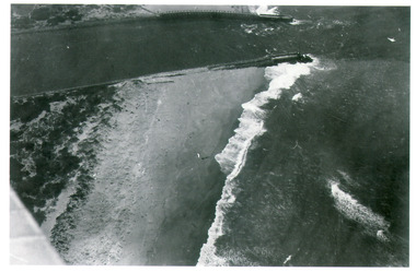
Photograph - Photograph - Aerial photograph of Portland harbour taken from the north east, 1967
Front: (no inscriptions) Back: Portland Harbour 1967/ No 6 berth under construction (ocean pier and railway pier still in existence)port of portland archives -
 Flagstaff Hill Maritime Museum and Village
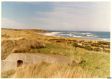
Photograph - Historical, Flagstaff Hill, Warrnambool Garrison Fortifications looking towards the Moyjil (Point Ritchie), 1970s
The photograph shows the location of the concrete, horseshoe shaped gun emplacement erected for the cannons. It is part of the Historic Precinct on Flagstaff Hill. The area was accessed either through the space between the Lighthouses (through the cottage grounds) or a service entrance, past the iron huts used by the Lands Department. This photograph, a print, is one of a set of five that show the site of Flagstaff Hill. It is presumed to have been taken by John Lindsay, Founding Director of Flagstaff Hill Maritime Museum and Village. One of the photographs in the set has the pencil inscription "Photo J Lindsay". It was taken in the early 1970s during the initial stages of the development of Flagstaff Hill as a Museum and Maritime Village. The photographs belonged to the donor's grandparents, who lived in the Warrnambool district of Allansford/Naringal. The photograph is a record of the site and surrounds of Flagstaff Hill Maritime Museum and Village before its development and opening in 1975. It shows the east side of the Surfside Holiday Park in its earlier days. The photograph is significant for recording the location and condition of the original concrete cannon emplacement on the Hill.Coloured photograph, glassy print, one of a set of five. Photograph shows the original site of one of the gun emplacements for the cannons, cannons Historical, looking towards the Moyjil, ,Point Ritchie and overlooking Lady Bay, Warrnambool. The horseshoe shaped concrete gun emplacement is in the foreground on the grassed slopes overlooking the Bay. The site and ablution block of the Surfside Holiday Park is centre right. The left shows the sore of Lady Bay with the cliffs of the Southern Ocean in the distance. The photograph's paper has the printer's watermark on the back. The early 1970s scene is presumed to have been photographed by John Lindsay, Warrnambool.Label on the back: "FIRST GUN EMPLACEMENT LOOKING TOWARDS THE HOPKINS / This is the original site of one of the cannons overlooking the Bay. Access to this area could be between the light-houses (throught the cottage grounds), or a service entrance - past the iron huts used by Lands Department."flagstaff hill, flagstaff hill maritime museum and village, warrnambool, maritime museum, maritime village, great ocean road, shipwreck coast, 1970s, photograph, gun emplacement, surfside holiday park, lady bay, hopkins river, flagstaff hill site, john lindsay, concrete gun emplacement, cannon emplacement, original emplacement -
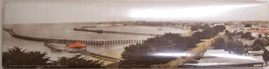 Glenelg Shire Council Cultural Collection
Photograph - Photograph - Portland Panorama, n.d
Plastic coated mounted on metal/fold out stand. View of Harbour taken from "All Saints" steeple. Contains - Baths, Ocean Pier, Long Pier, Fishermans Wharf. Bentinck Street. Unseated - Truck loaded with wool bales. Power poles. Red roofs on Baths, Court House, Richmond Hotel, Bank of Australasia Hand coloured.Front: Panorama of Portland, Victoria (length of Ocean Pier 2880 ft).harbour, photography -
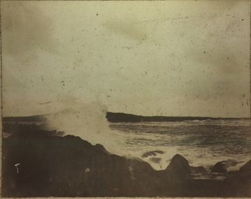
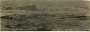 Port Fairy Historical Society Museum and Archives
Photograph
Black and white photographs of the Southern Ocean crashing on the reef these are glued together back to backbeach, ocean, south, sea, rocks, waves -
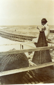 Lakes Entrance Historical Society
Photograph - Navigation Basket, 1920c
Also black and white copy 20 x 14 cmBlack and white photograph showing navigational baskets used at entrance to Gippsland Lakes from Bass Strait. Girl sitting on handrail framework, looking at eastern pier and ocean. Lakes Entrance Victoria navigation, ocean -
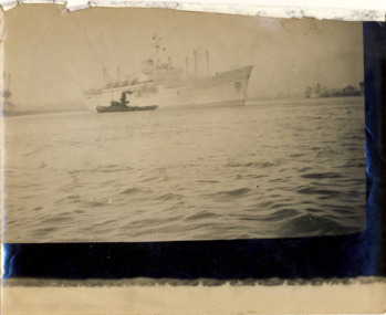 Kew Historical Society Inc
Photograph - Port of Melbourne, circa 1953
This is one of a series of 17 black and white undated photographic proofs donated to the Kew Historical Society in 2013 by the Queenscliffe Historical Museum. The series includes images of individuals, tea rooms, ferries, motor launches, ocean liners and tugs. One of two faded black and white photographic proofs of a tugboat and an ocean liner in the Port of Melbourneyarra river, tugboats, shipping, ships, port of melbourne -
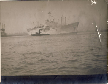 Kew Historical Society Inc
Photograph - Port of Melbourne, circa 1953
This is one of a series of 17 black and white undated photographic proofs donated to the Kew Historical Society in 2013 by the Queenscliffe Historical Museum. The series includes images of individuals, tea rooms, ferries, motor launches, ocean liners and tugs. One of two faded black and white photographic proofs of a tugboat and an ocean liner in the Port of Melbourneyarra river, tugboats, shipping, ships, port of melbourne