Showing 36250 items
matching old-royal-hotel
-
 Tatura Irrigation & Wartime Camps Museum
Photograph - original, A. Gye Photographer, Hogans Commercial Hotel and Store, late 1880's
Original sepia photograph of Thomas Hogan's Commercial Hotel and Cash Drapery Store. Signs on building - Hogan's Commercial Hotel, Cash Drapery, cheap boot and shoe ware house. London House, sign post made from gum tree.Sepia original photograph of many men, women, children, horses and buggies in front of Hogan's Commercial Hotel and store.on back: Thomas Hogan's Commercial Hotel and Cash Drapery Store, Ross Street, Tatura.hogans commercial hotel -
 Whitehorse Historical Society Inc.
Photograph, Travellers Rest Hotel, Blackburn. ( Blackburn Hotel), 1929
Negative and copy of front page of a booklet entitled Blackburn Progress - Out goes the old - Up goes the new. Underneath photo 'A fine new residential hotel replacing it's predecessor'.Travellers Rest Hotel, Blackburn, with partly built new Blackburn Hotel to the west in 1929. See also NP749.travellers rest hotel, whitehorse road, blackburn -
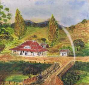 Greensborough Historical Society
Painting, Lower Plenty Hotel c1940-1950, 1940-1950
Artists impression of the Lower Plenty Hotel mid-20th century. An original painting of the Lower Plenty Hotel.Mixed media on canvas board. Landscape with hotel in middle ground.Signed with initials "S.J." on front. On back: "From photo. Painted 1960-1970. LOWER PLENTY HOTEL c1940-1950. Sylvia Jones"lower plenty, lower plenty hotel, sylvia jones -
Clunes Museum
Poster, DESIGNED AND SCREEN PRINTED BY MAGARET FINNEGAN 1991, CIRCA 1991
POSTER FOR ARTISTS EXHIBITION AT OLD BUTTER FACTORY CAMERON STREET CLUNESNEIS ARTISTS EXHIBITION & SALE AT THE OLD BUTTER FACTORY OCT.26TH TO NOV.23RD. 1991local history, document, poster, old butter factory -
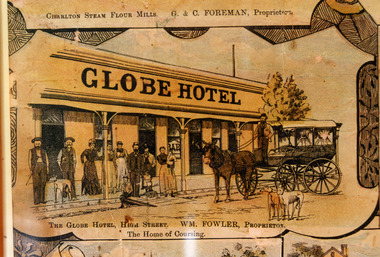 Charlton Golden Grains Museum Inc
Photograph - Lithograph, Rider & Mercer, Views of Charlton, c.1988
The Globe Hotel built 1874-75 for John Walsh was destroyed by fire and rebuilt in ?. Leased by William Fowler in 1891 who had been in Charlton since 1877. Copy of Lithograph of Charlton buildings. Large sign on building 'GLOBE HOTEL'. Eight men and women and three children standing in front of building, a horse and wagon also in front of the building with a man standing in the wagon holding the reins. Two greyhounds on the road.The Globe Hotel, High Street. WM. Fowler, Proprietor. The Home of Coursing.lithograph, globe hotel, fowler william, walsh john -
Moorabbin Air Museum
Book - LISTOF MEMBERS as at 1st January, 1972 THE ROYAL AERONAUTICAL SOCIETY, THE ROYAL AERONAUTICAL SOCIETY, 1972
LISTOF MEMBERS as at 1st January, 1972 THE ROYAL AERONAUTICAL SOCIETYBlue cover with faded gold title lettering "LISTOF MEMBERS as at 1st January, 1972 THE ROYAL AERONAUTICAL SOCIETY" plus official seal at topnon-fictionLISTOF MEMBERS as at 1st January, 1972 THE ROYAL AERONAUTICAL SOCIETY -
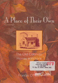 Eltham District Historical Society Inc
Book, Frances O'Neill, A place of their own : the old colonists' homes in Victoria / Frances O'Neill, 2005
Paperback; viii, 201 p., [16] p. of plates : ill., maps, ports. ; 25 cmISBN 1740970675houses, buildings, victoria -
 Stawell Historical Society Inc
Book, Radio Amateure Old Time Club, Journal of the Radio Amateur Old Timer's Club of Australia, No 3 1987, 1987
stawell -
 Warrnambool and District Historical Society Inc.
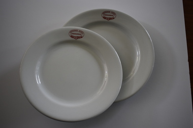
Crockery, Hotel Criterion Plates, Mid 20th century
These dinner plates were used at the Criterion Hotel in Kepler Street, Warrnambool, about the mid 1900s. The Criterion Hotel was opened in 1872 with the first licensee, John Tate. The Humm family was associated with the hotel from the 1880s to 1919 and members of the McGennan family were licensees and owners of the hotel for over 50 years in the 20th century. The hotel closed in 2008 and the building was demolished in 2013.These plates are of great interest as excellent examples of the dinner plates used at the Warrnambool Criterion Hotel in the mid 20th century. The Criterion Hotel was a Warrnambool landmark for over 130 years.These are two white vitrified china plates. One is slightly smaller than the other but they are both dinner –plate size and made for hotel use. They are circular in shape with a wide outer band and the base or body of the plates slightly recessed. The name of the hotel is printed in red on the side of the plates in an oval decorative pattern. Details of the manufacturer and supplier are printed on the bottom of the plates. There are few stains or markings on the plates, suggesting they have been little used‘Criterion Hotel Warrnambool’ ‘Globe Pottery Co. Ltd. Cobridge England Vitrified’ ‘John Dynon & Sons Melbourne’criterion hotel, warrnambool, history of warrnambool -
 Koroit & District Historical Society
Koroit Hotel
For more information on this hotel see "Time Gentlemen Please"The Royal mail coach with passengers along with people, horses and a dog posed for the photograph outside Bruce's Koroit Hotelhotel, koroit hotel, royal mail coach, bruce's koroit hotel -
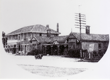
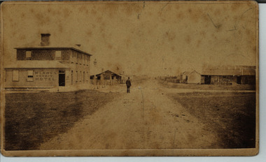
Tatura Irrigation & Wartime Camps Museum
Photograph - original, A. Gye Photographer, Tatura Old Buildings, 1870's original
Original sepia photograph of Ross's Hotel and Store, se corner of Ross and Hogan Streets, Tatura. McNaughton, Lacey, London House, Cash Drapery. sw corner of Ross and Hogan Streets, Tatura among earliest buildings in Tatura.Old Sepia original photograph of 2 old buildings on Ross and Hogan Streets corner. A number of men standing on roadway.on back: names of buildings. Ross's Hotel and Store. McNaughton Lacey. Details below.ross's hotel and store -
 Sunbury Family History and Heritage Society Inc.
Photograph, Ball Court Hotel
The hotel was built some time shortly after 1842 by John Cahill, who arrived in the colony in 1842 from Thurles in Tipperary, Ireland. The building although much altered with render covering the original \blue stone structure is on the south-west corner of Macedon and Jackson Streets. The hotel was called the Ball Court because Cahill also had a hand-ball court set up behind the hotel.Originally five hotels were built along Macedon Street between Jackson Creek and Evans Street. The Ball Court Hotel is the only one still standing and operating as a hotel.A non-digital black and white photograph with a cream border of man and three ladies standing outside a single story blue stone hotel building with a corner entrance. AS well as the corner entrance there is another doorway on the RHS along with three narrow windows and three other windows on the other side. One of the ladies is holding a little child. Two trees surrounded by tree guards are on each side of the photograph.Ball Court Hotel, John Cahillball court hotel, hotels, sunbury, macedon street, jackson street, ball court -
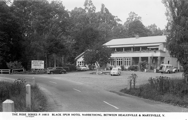 Marysville & District Historical Society
Postcard (Item) - Black and white postcard, Rose Stereograph Company, BLACK SPUR HOTEL, NARBETHONG, BETWEEN HEALESVILLE AND MARYSVILLE, V, 1913-1967
A digital copy of a black and white postcard of the Black Spur Hotel in Narbethong. This postcard was produced by The Rose Stereograph Company as a souvenir of Narbethong.A digital copy of a black and white postcard of the Black Spur Hotel in Narbethong.THE ROSE SERIES P. 10813/ COPYRIGHT. BLACK SPUR HOTEL NARBETHONG, BETWEEN HEALESVILLE & MARYSVILLE, V.narbethong, victoria, australia, black spur hotel, accommodation, black spur inn, blacks' spur inn, blacks' spur hotel, rose stereograph company, postcard, souvenir, p. 10813 -
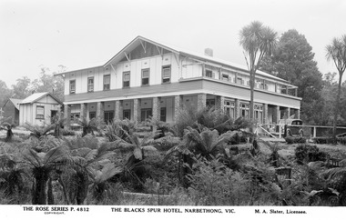 Marysville & District Historical Society
Postcard (Item) - Black and white postcard, Rose Stereograph Company, THE BLACKS SPUR HOTEL, NARBETHONG, VIC, 1913-1967
A digital copy of a black and white photograph of the Blacks Spur Hotel in Narbethong. This postcard was produced by The Rose Stereograph Company as a souvenir of Narbethong.A digital copy of a black and white photograph of the Blacks Spur Hotel in Narbethong.THE ROSE SERIES P. 4812/ COPYRIGHT THE BLACKS SPUR HOTEL, NARBETHONG, VIC. M. A. Slater, Licensee.narbethong, victoria, australia, black spur hotel, accommodation, black spur inn, blacks' spur inn, blacks' spur hotel, p. 4812, rose stereograph company, postcard, souvenir, m a slater -
 Port of Echuca
A black and white photograph, The Bridge Hotel, in 1896, showing Silky Oak trees, 1970's
The Bridge Hotel was built by Henry Hopwood to house visitors to the town crossing the Murray River on his punt crossing, which was situated just below the Bridge Hotel on the Murray River. The accommodation was spacious and grand! In the right back corner of the photograph, the 'lantern' roof of the St Georges Hall can be seen. The street is level with the front entrance to the Hotel, which is very different to what it is today.The photograph shows hotel activities and accommodation in the late 19th Century.A black and white photograph of the Bridge Hotel taken from the Hopwood Gardens. The photograph shows four silky oak trees growing along the front of the building. There is an empty flag pole outside the front of the building. The right wing advertises billiards, whilst the left wing apparently was a bar.Written on the building can be seen the words; HOTEL and BILLIARDS. Written in pen on the back of the photograph are the words "Bridge Hotel. Probably 1896, showing Silky Oak trees.bridge hotel, henry hopwood, silky oak trees, lantern roof, st georges hotel -
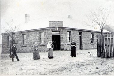
 Tarnagulla History Archive
Photograph of Company's Hotel, Tarnagulla, Company's Hotel, Tarnagulla, c.1866-1970
Murray Comrie Collection. Information written by Donald Clark, (source Tarnagulla: A history of Tarnagulla and Districts website): The hotel was built on Commercial Road in 1859 and was opened on 26/12/1859. Festivities lasted for three days on opening. The building was of two storeys, built of brick and plastered throughout. It contained one bar, three parlors, billiard room, dining room, and four bedrooms with twelve others detached from the main building. Other out buildings consisted of kitchen etc. and stables to accommodate 30 horses. There was an underground tank capable of holding 3000 gallons of water. The licence was granted to Patrick McDermott at the Dunolly Court on 17/2/1860 and renewed on General Licensing Day on 12th June, 1860, and was transferred to William Hawkins in 1861. The premises became the headquarters of the Bet Bet Roads Board, following which it became the Council Chambers for the Borough of Tarnagulla, until 1915. The building was beyond repair and was removed by pulling the place down and storing the material for use of the Public Hall Committee. This took place on March 27th and 28th, 1981. This image must be after 1866, when the building was purchased for use as Council Chambers and the original heavy cornice was removed as that is not present in this image. This photograph is a reasonable copy created from an older original. Monochrome photograph depicting Company's Hotel in Tarnagulla. At the time of the photograph the old hotel is being used as the Mechanics' Institute. tarnagulla, hotels, company's hotel, companys hotel, burstall hall, businesses, commercial road -
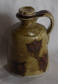 Buninyong Visitor Information Centre
Container - Ceramic Jar, Old Library Pottery, Ceramic Jar with stopper and handle, Unknown
Made in the old Buninyong Library building which leased rooms to the potter. Small clay jar with brown glaze and bat-like red coloured figure patterning. Small stopper and handle at the top. Old Library Pottery, G.S.C., Buninyongceramics, pottery, old library pottery -
 Stawell Historical Society Inc
Photograph, The old Wimmera Hotel in Glenorchy -- 2 Photos
Two B/W photographs of Residence - was Wimmera Hotel. Glenorchystawell -
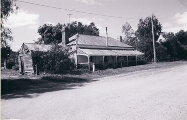
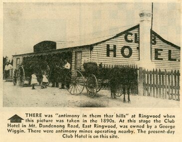 Ringwood and District Historical Society
Photograph - Newspaper Clipping, Early View of Club Hotel, Ringwood East
The newspaper clipping caption is incorrect. The Club Hotel featured in the article was located on the north side of Mount Dandenong Road. It was destroyed by fire in 1890 prior to re-opening later on the south side where it operated until sale and demolition in 2020 to make way for a retirement village. (See PDF attached - "SS0067 Vic Collections 3754b - Club Hotel Fire 1890").Early View of Club Hotel, Ringwood East. Weatherboard with iron roof. Single chimney on one end. Picket fence on RHS. Two horse-drawn vehicles standing out front including three adults and two children. Source/date of newspaper unknown. Later newspaper item also attached reporting hotel being destroyed by fire in 1890.Caption: There was 'antimony in them thar hills' at Ringwood when this picture was taken in the 1890s. At that time the Club Hotel in Mt Dandenong Road, East Ringwood was owned by a George Wiggin. There were antimony mines operating nearby. The present-day Club Hotel is on this site. -
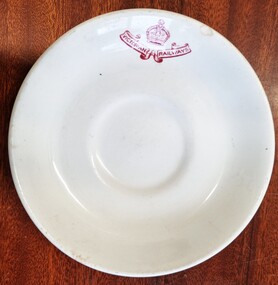 Wodonga & District Historical Society Inc
Functional object - Victorian Railways Bowl, Grindley Hotel Ware, May 1954
The Grindley Hotel Ware Co Ltd was located in Stoke-on-Trent, England with its business name being registered in May 1908. The product name "Duraline" came into use c1933. From 1932 ware was marked with the month and year of manufacture. Thus the numbers 5-54 underneath this item indicate that it was manufactured in May 1954. Mr. Loftus Henry Moran, born in Winchelsea, Victoria, was well-known in the tea trade, originally working with Griffiths Bros Ltd. He started his own business, Loftus Moran Pty Ltd in 1909. Loftus Moran's company imported chinaware from Britain and sold it into the Australian market. They specialised in supplying to hotels, businesses and institutions.This item is representative of chinaware used throughout hospitality venues and public institutions throughout Australia.A white ceramic bowl bearing a red emblem of Victorian Railways. The mark of the maker Grindley Hotel Ware and the Victorian supplier, Loftus & Moran Pty, Ltd is underneath the bowl.On front: Victorian Railways On Back: "DURALINE" /SUPER VITRIFIED/ GRINDLEY HOTELWARE CO./ ENGLAND LOFTUS MORAN PTY. LTD. / MELBOURNE 5 - 54duraline, victorian railways, grindley hotel ware -
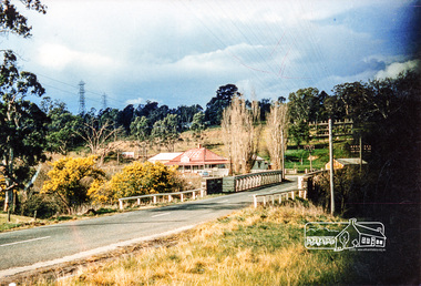 Eltham District Historical Society Inc
Photograph, Old Lower Plenty Bridge and Hotel
Colour photograph of Lower Plenty Bridge from the west prior to opening of new bridge. Hotel in background. 4 x 6 print and also laminated 8 x 10 print.lower plenty, main road, plenty river, golf club hotel, hotels, bridges -
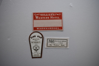 Warrnambool and District Historical Society Inc.
Label, Gaspars Modern Print, Hillier’s Western Hotel, Early 20th century
These labels come from the Western Hotel in Warrnambool . The Western Hotel at the corner of Timor and Kepler Streets in Warrnambool was opened in 1870 and was a prominent hotel in the area until it closed in recent years. Thomas Hillier was the licensee from 1901 to 1906. These labels are of interest as mementoes of a former prominent hotel in Warrnambool – the Western Hotel..1 A cream-coloured card with cream printing on a red background and space for an address. .2 A label from a whisky bottle with gilt edging, gold-coloured lettering and a whisky logo. The paper has a straight-edged base and an oval-shaped top. .3 A small sheet of white paper with gold-coloured edging and printing and a whisky logo. .1 Hillier’s Western Hotel Warrnambool .2 Fine Old Scotch Whisky bottled by T.G.L. Hillier Western Hotel Warrnambool .3 Finest Scotch Whisky bottled by T.G.L. Hillier The “Western” Blend western hotel,, thomas hillier, history of warrnambool -
Moorabbin Air Museum
Booklet - The Shuttleworth Collection, David Ogilvy, 70th Anniversary ROYAL AUSTRALIAN AIR FORCE
-
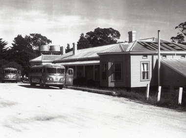 Lakes Entrance Historical Society
Photograph - Kalimna Hotel, 1960c
This is the before paired photograph used in the 150 year, Lakes Entrance 1858-2008 display.|The after paired photograph number is 01335.1|Also one 12 x 16 framed photograph used in room display.| The hotel was owned by Ansett and used by their coaches for a meal stop-off point. The Kalimna is often referred to as the Hotel with a View.Black and white enlarged photograph showing original Kalimna Hotel prior to a fire in 1962 which burnt the old bar on the Eastern end of the hotel. Dirt road at front with two Ansett buses and people in front of hotel. Two water tanks, three chimneys and hotel painted on top of roof. Lakes Entrance Victoria,restaurant, hotels, room display -
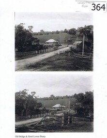 Greensborough Historical Society
Photograph (copy), Old Bridge and Hotel Lower Plenty, 1925c
2 historical views of the Lower Plenty bridge and hotel. Original photographs are in the Victorian State Library collection.Both the bridge and hotel remain but are in a very different landscape. This shows the area about 110 years ago.A4 photocopy of 2 black and white photographslower plenty, lower plenty hotel, plenty river, lower plenty river bridge. -
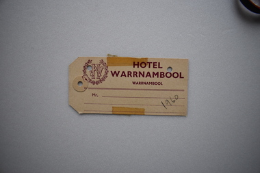 Warrnambool and District Historical Society Inc.
Label, Hotel Warrnambool, Early 20th century
The Hotel Warrnambool, the second in Warrnambool to have that name, was built on the site of the old Hotel Mansions (Ozone Coffee Palace / Ozone Hotel) which was destroyed by fire in 1929. The Hotel Warrnambool was opened in 1931 using the licence transferred from the Hotel Mansions. It has played a major role in the social and economic life of the city since this time.This luggage label from the Hotel Warrnambool is of some historical significance as the hotel is a prominent one in Warrnambool today built on the site of the Hotel Mansions regarded as the finest building ever to be erected in Warrnambool. Buff coloured rectangular label with maroon text. Two corners of the card are mitred. The label features a open ended wreath with the letters WH entwined in its centre. There are three punched holes , one with a reinforce sticker. Two pieces of adhesive tape are attached on the top and the bottom. HOTEL WARRNAMBOOL WARRNAMBOOL( In smaller font). Mr. ..... 1960 (in pencil) hotel warrnambool, ozone coffee palace, ozone hotel, warrnambool -
 Friends of Ballarat Botanical Gardens History Group
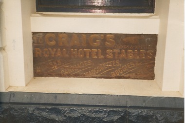
Work on paper - Address Delivered by Mr A.E.C.Kerr, President, Adam Lindsay Gordon Memorial Cottage Committee, 3/4/1938, To honour the Late President Mr Fred J. Martell. Photograph attached of metal plaque at Craig's Hotel entitled "Royal Hotel Stables", 3/4/1938. Photograph-date unknown
The Address in honour of the memory of the Late Fred J. Martell given 3/4/1938, President of the Adam Lindsay Gordon Memorial Cottage was delivered by Mr A.E.C.Kerr, President of the Adam Lindsay Gordon Memorial Cottage Committee, Ballarat. The photograph of Craig's Hotel Stables' sign is included as Adam Lindsay Gordon held the leasehold of these livery stables in 1867.Mr Martell made valuable contributions to the Ballarat community as one of the Founders of the Ballarat Art Gallery, Registrar of the School of Mines and was "really [the] founder" of the Lindsay Gordon Memorial Cottage. His ashes were scattered around the Cottage.8 pages with 3 illustrations and 2 title pages. The 3 black and white illustrations are of Fred J. Martell, the Adam Lindsay Gordon Memorial Cottage and Adam Lindsay Gordon. The photograph of Craig's Stables is high gloss in colour. Nonejohn garner, doctor, john garner collection, ballarat botanic gardens, friends of ballarat botanical gardens, fred j. martell, mr a.e.c.kerr, adam lindsay gordon cottage, adam lindsay gordon memorial cottage committee, craig's royal hotel ballarat, craig's hotel livery stables, craig's hotel livery stables metal plaque, dougles sladen, poet's corner westminster abbey, bath lane, australian poet, adam lindsay gordon bust, gardens, ballarat -
 Ringwood and District Historical Society
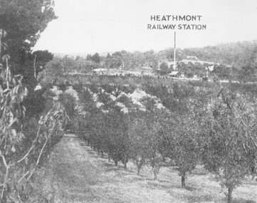
Photograph, View of what was Heathmont township taken from about Royal Avenue looking at Mr. Herman Pump's orchard. Old bridge over Canterbury Road can be seen on left
Typed below photograph, "View of what was Heathmont township taken from about Royal Avenue looking at Mr. Herman Pump's orchard. Old bridge over Canterbury Road can be seen on left." -
 Whitehorse Historical Society Inc.
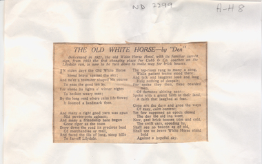
Article, C. J. Dennis, White Horse Hotel, poem by C.J. Dennis, July 1933
The Old White Horse by "Den" History of the White Horse Hotel at Box Hill which was established by Patrick Trainer.Article quoting a poem by 'Den' titled The Old White Horse about the White Horse Hotel and its history.The Old White Horse by "Den" History of the White Horse Hotel at Box Hill which was established by Patrick Trainer.white horse hotel, cobb & co, hotels, box hill, trainer patrick, nunawading road board -
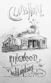 Ringwood and District Historical Society
Photograph, Club Hotel - 1889
Black and white print of drawing of Club Hotel.Written around photograph, Club Hotel, Ringwood. J.L. Lindsay, Proprietor". Typed below, "Club Hotel - 1889".