Showing 11315 items
matching orient-line
-
 Lakes Entrance Historical Society
Book, Barraclough, Linda; Squires, Debra; Savige, Dr.Walter, Gippsland Time Line to 1899, 2010
A Gippsland time line - from before time began, until 1899, acquired from Internet, based on a Gippsland chronology to 1899.history, aboriginals, exploration -
 Melbourne Tram Museum
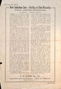
Pamphlet - Real estate sale, T M Burke, "New Suburban line - Darling to Glen Waverley", July 1926
Pamphlet advising potential land purchasers of the recommendation to extend the railway line from Darling to Glen Waverley, extracted from The Age 26/6/1926. Advises that the land and losses would be paid for by the residents through their rates. Gives costs of the proposed new line. Has a plan showing the estates for sale along the line, the Ashburton line (later extended to Alamein) and Burwood Road. Published by T M Burke Pty Ltd. Demonstrates the style of land sale pamphlet including the proposed availability of train services to prospective purchasers.Pamphlet - single quarto sheet with map on rear - printed.sale of land, real estate, railways, glen waverley, suburban railways -
 Melbourne Tram Museum
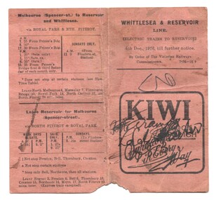
Ephemera - Timetable, Victorian Railways, "Whittlesea & Reservoir Line", Dec. 1926
Timetable - folded brown card titled "Whittlesea & Reservoir Line" dated 6/12/1926 detailing train services on the Reservoir (Whittlesea, currently Mernda) rail line. Shows the trains that ran via Royal Park, or Clifton Hill. The Royal Park services were in effective competition with the tramways. Has an advert for Kiwi Boot Polish.trams, tramways, timetables, vr, reservoir, clifton hill, royal park, inner circle -
 Ringwood and District Historical Society
Photograph-B&W, Joan Walker, East Ringwood 2000-Pedestrian crossing over the railway line looking towards Croydon, 2000
East Ringwood 2000-Pedestrian crossing over the railway line looking towards Croydon- B&W Photo from Album 6501 -
 Melbourne Tram Museum
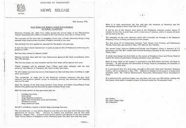
Document - Photocopy, Minister of Transport, "New tram line brings major improvement to public transport", 10/01/1985 12:00:00 AM
Press release - photocopied onto two A4 sheets, stapled in top left hand corner, issued 10/1/1985, titled "New tram line brings major improvement to public transport", for the opening of the tram line to Kingsbury Drive near Latrobe University - notes the background to the extension and future proposals to go to Bundoora. Opened by John Cain.trams, tramways, mta, opening, la trobe university -
 Eltham District Historical Society Inc
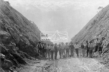
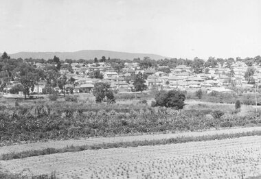
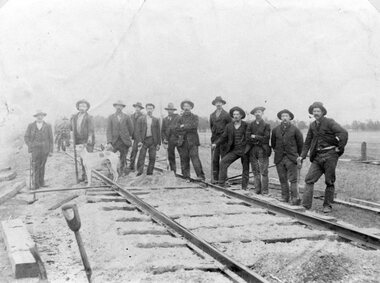
Photograph, Construction of Railway Line, Greensborough to Eltham
Large group of railway workers stand in a line, in a cutting, some holding shovels. The track has not been laid yet. The opening of the railway line from Heidelberg to Eltham took place on the 6th June 1902. This photo forms part of a collection of photographs gathered by the Shire of Eltham for their centenary project book,"Pioneers and Painters: 100 years of the Shire of Eltham" by Alan Marshall (1971). The collection of over 500 images is held in partnership between Eltham District Historical Society and Yarra Plenty Regional Library (Eltham Library) and is now formally known as the 'The Shire of Eltham Pioneers Photograph Collection.' It is significant in being the first community sourced collection representing the places and people of the Shire's first one hundred years.Digital imagesepp, shire of eltham pioneers photograph collection, montmorency, eltham, greensborough, railway line construction, cutting, railway workers, hurstbridge railway line -
 Melbourne Tram Museum
Document - Instruction, Melbourne & Metropolitan Tramways Board (MMTB), "Line Breakers GE and EE type - Electrical Mechanics Procedure", May. 1970
Instruction - 2 pages - duplicated foolscap sheets - headed "MMTB Engineering Department - Workshops and Running Shed Branch" - titled "Line Breakers GE and EE type - Electrical Mechanics Procedure" Details electrical work to be done on the rostered day in for GE and EE type line breakers, maintenance, checks, adjustments, safety, testing and closing the boxes. Dated May 1970.trams, tramways, depot, safety, workshops, electrical equipment, instructions, procedures, controllers -
 Numurkah & District Historical Society
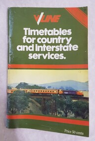
Booklet, V/Line Timetables for country and interstate services
90 page booklet of V/Line timetables. Effective October 27 1985. Green banner with pic of train engine and carriages. Price 50 cents -
 National Vietnam Veterans Museum (NVVM)
Photograph, Gibbons, Denis, Crossing Of The Line
Denis Gibbons (1937 – 2011) Trained with the Australian Army, before travelling to Vietnam in January 1966, Denis stayed with the 1st Australian Task Force in Nui Dat working as a photographer. For almost five years Gibbons toured with nine Australian infantry battalions, posting compelling war images from within many combat zones before being flown out in late November 1970 after sustaining injuries. The images held within the National Vietnam Veterans Museum make up the Gibbons Collection. A black and white photograph of a digger from 9 RAR is given a haircut during the "crossing of the line" ceremony on board the Vug Tau Ferry HMAS Sydney. photograph, 9 rar, vung tau ferry, hmas sydney, gibbons collection catalogue, digger, denis gibbons -
 Ringwood and District Historical Society
Photograph, New housing developments, New Street, 1960 viewed from railway line near Madden Street looking south-east
Written on back of photograph, "New housing settlement New Street, 1960. From railway line near Madden Street looking south-east. Dam centre foreground". -
 Australian Queer Archives
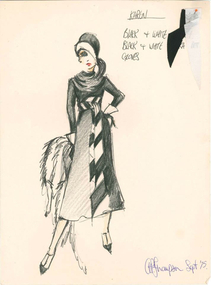
Costume design, Thompson, Anthony, Costume design for Karen in The Line-Up, Capriccio's, September 1975, September 1975
The Line Up was produced by David Mitchell and David Penfold.drag -
Malmsbury Historical Society
Photograph (Item), Railway Line Along Coliban River, Malmsbury ca2003
Buildings - Railway Line People - "Tynan, Alexandra (Photographer)" -
 Circa Vintage Archive
Printed silk evening coat 1930s, Floral and butterflies silk princess line evening coat 1930s, Late 1930s
Evening or opera coat with princess line seams and shawl collar. Leg o' mutton sleeves, full length flared skirt of six panels and secured with one self covered button and bound buttonhole at the waist. Fully lined in cream coloured silk taffeta. Fabric is printed in gold with flowers, vines and butterflies with hand silk screened roses and forget-me-not flowers over the topNone -
 Wodonga & District Historical Society Inc
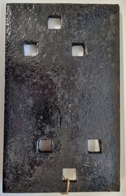
Functional object - Rail fish plate from Cudgewa Line, 1930 - 1960s
Cudgewa Line -The Cudgewa railway line opened in stages between 1889 and 1921. The first section from Wodonga to Huon opened on 10 September 1889. It was extended to Bolga on 18 July 1890, Tallangatta on 24 July 1891, Shelley on 13 June 1916 (the highest station in Victoria), Beetomba on 10 April 1919 and Cudgewa on 5 May 1921. The line had 1 in 30 grades and trestle bridges that have been heritage listed. In 1919, the line was used to carry materials for the construction of Hume Weir, and three years later a spur line connecting Ebden to the weir was opened. In the 1960s, Cudgewa became the railhead of materials for the Snowy Mountains Scheme. The last passenger service from Wodonga to Tallangatta ran on 30 September 1961. The turntable and passenger platform at Cudgewa were abolished in 1976. This fish plate came from the rails of the Cudgewa Line at Gordon Roy's hut which was situated behind Perry's Stump Hotel outside Wodonga. The hut was used as an office with the points lever outside to switch trucks to different tracks on the Bandiana and Cudgewa lines.This item is significant as it was part of the railway line to Cudgewa which played an important role in North east Victoria carrying freight during the construction of the Hume Weir and the Snowy Mountains Scheme.A section of flat plate. These plates were used in pairs to connect the ends of adjacent rails in railway track. victorian railways, cudgewa rail line, railway components -
 Greensborough Historical Society
Newspaper Clipping, Diamond Valley Leader, Buses on line in February, 24/01/2018
Buses will continue to replace trains on the Hurstbridge line next month.News article 1 page, black text.public transport victoria, buses replace trains, hurstbridge rail line -
 Greensborough Historical Society
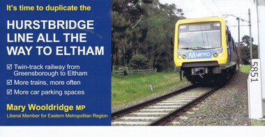
Leaflet, Mary Woolridge MP, It's time to duplicate the Hurstbridge line all the way to Eltham. Issued by Mary Woolridge MP, 2018
Liberal Party information leaflet on the duplication of the Hurstbridge rail line.2p. colour leaflet, printed both sideshurstbridge rail line -
 Stawell Historical Society Inc
Photograph, Stawell Water Supply Fume & Line Borough Huts 1919
Stawell Water Supply Fume Line Borough Huts 1919stawell -
 Stawell Historical Society Inc
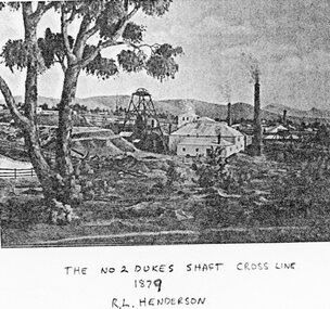
Photograph, No 2 Dukes Shaft Cross Line 1879
Mining Scene - No2 Dukes Shaft Cross Line 1879stawell -
Malmsbury Historical Society
Photograph (Item), Steam Trains On Bendigo Line, Malmsbury c1991
Associated with - M.H.S. Buildings - Road Bridge Over Railway Line -
 Ringwood and District Historical Society
Photograph, Looking along railway line from Ringwood station.Circa 1910
Typed below photograph, "Looking along railway line from Ringwood station. Club Hotel can be seen above roof of church. Maroondah Hwy on left. Circa 1910". -
 Melbourne Tram Museum
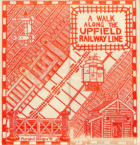
Pamphlet, Brunswick Community History Group, "A walk along the Upfield railway line", 1993
Pamphlet or small booklet, 12 pages on recycled paper, centre stapled titled "A walk along the Upfield railway line", outlining the history of the line, dates, hand operated gates, Royal Park to Brunswick, cable trams and the Sarah sands, sketches, The Jewell, map, Brunswick Station, grain stores, substation, Brunswick tram depot, sidings and railway signals. Published by the Brunswick Community History Group in 1993In ink page 3 "KS 8-7-94"trams, tramways, upfield, brunswick, railways, level crossings -
 Bendigo Military Museum
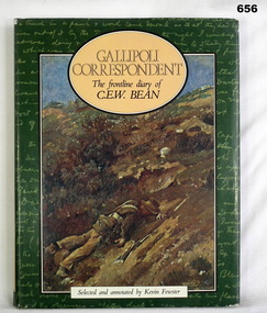
Book, Kevin Fewster, Gallipoli Correspondent - F/Line Diary of C. E. W. Bean, 1983
Edited correspondence from the Gallipoli front line diary of CEW Bean.217 page, cut edged, illustrated hardcover book. Black buckram covers with illustrated dust jacket. Title in gold on spine. Illustrated end papers.On title page "Kath Watson 3566"books- military, documents diaries -
 Stawell Historical Society Inc
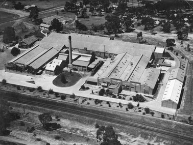
Photograph, North Western Woollen Mills with the Rail line in foreground -- Aerial View
North Western Woollen Mills Aerial View. Rail line in foregroundstawell industry -
 Stawell Historical Society Inc
Photograph, Railway Line from the Oddfellows Bridge c1930's
Sepia Photograph of rail line from Oddfellows Bridge 1930'sstawell railways transport -
Whitehorse Historical Society Inc.
Article, Box Hill-Ringwood Line, 1/02/1961 12:00:00 AM
The Box Hill - Ringwood Line by J.F. Sinnat and J.D. McLean, p.2-9, Divisional Diary,The Box Hill - Ringwood Line by J.F. Sinnat and J.D. McLean, p.2-9, Divisional Diary, Australian Railways Historical Society, Victorian Division, February 1961.The Box Hill - Ringwood Line by J.F. Sinnat and J.D. McLean, p.2-9, Divisional Diary, railways, mclean, j.d., sinnat, j.f., blackburn railway station, nunawading railway station, mitcham railway station -
 Stawell Historical Society Inc
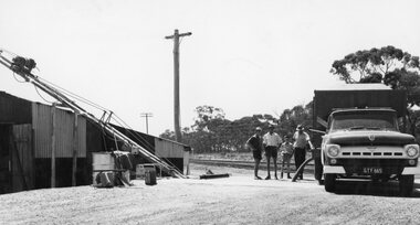
Photograph, Grain Storage Site beside railway line in Griffin Street with a truck unloading
Grain Storage Site beside railway line Griffin Street truck unloading.stawell -
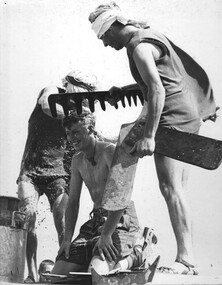
 Stawell Historical Society Inc
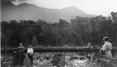
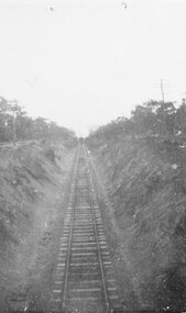
Photograph, Railway Line Construction in Stawell area -- 4 Photos
Large group of men carrying out Railway Line Construction in Stawell area.stawell railways transport -
 Wodonga & District Historical Society Inc
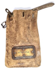
Functional object - Leather pouch and stamps - Cudgewa Railway Line
Cudgewa Line -The Cudgewa railway line opened in stages between 1889 and 1921. The first section from Wodonga to Huon opened on 10 September 1889. It was extended to Bolga on 18 July 1890, Tallangatta on 24 July 1891 and then to Shelley on 13 June 1916. Shelley was the highest station in Victoria. It extended further on to Beetomba on 10 April 1919 and finally reached Cudgewa on 5 May 1921. The line had 1 in 30 grades and trestle bridges that have been heritage listed. In 1919, the line was used to carry materials for the construction of Hume Weir, and three years later a spur line connecting Ebden to the weir was opened. In the 1960s, Cudgewa became the railhead of materials for the Snowy Mountains Scheme. The last passenger service from Wodonga to Tallangatta ran on 30 September 1961. The turntable and passenger platform at Cudgewa were abolished in 1976. These stamps were used by Joh Murray who for many years worked with Victorian Railways based at Wodonga.A leather pouch with belt and lock. It bears a metal name tag inscribed with name of railway station. The pouch contains 3 station stamps, a date stamp and 2 carriage keys.On pouch WODONGA On stamps: BONEGILLA 1470/ EBDEN 1471/ BANDOLIER 1473cudgewa rail line, victorian railways, closed victorian railways, railway stamps -
 Ringwood and District Historical Society
Photograph-B&W, Joan Walker, East Ringwood 2000- Roundabout in Railway Avenue cnr Wenwood Street looking West (railway line on right hand side), 2000
East Ringwood 2000- Roundabout in Railway Avenue cnr Wenwood Street looking West (railway line on right hand side)- B&W Photo from Album 6501 -
 University of Melbourne, Burnley Campus Archives
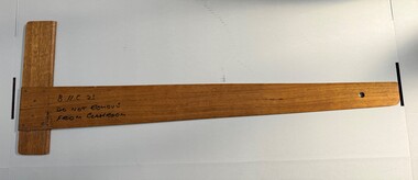
Functional object - Straight line classroom board ruler, <1983
Custom made for the Burnley Horticultural College classrooms (prior to 1983)Hardwood custom made classroom aid - a straight line ruler with right angle. Written on with texta and stamped in the wood. Hole drilled in non right angle end to hang on a nail.Text marked 'B.H.C. 23 Do not remove from classroom'. Stamped in the wood 'B.H.C'.burnley horticultural college, teaching aid, classroom aid