Showing 225 items matching "panoramic views"
-
 Bendigo Historical Society Inc.
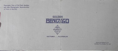
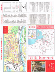
Book - Golden Bendigo
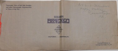
... , the forest city Victoria...Australia. Panoramic view of Pall Mall..., the forest city Victoria...Australia. Panoramic view of Pall Mall ...BHS CollectionFourteen pages booklet with grey cover and small red rope tying the pages together. On the front Golden Bendigo, the forest city Victoria...Australia. Panoramic view of Pall Mall, Bendigo and other photographic reproductions of views of the city. Printed and published by Cambridge Press, Bendigo.bendigo, golden bendigo, photographs of bendigo -
 Federation University Historical Collection
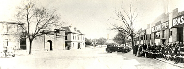
Photograph (black & white), M.B. John Brass Foundry Workers, 1927
... one large panoramic view is made, which also includes... at their Armstrong Street factory. When joined together one large panoramic ...In 1896 M.B. John started the Ballarat Brass Foundry in Armstrong Street South on land leased from the Welsh Church. See http://bih.ballarat.edu.au/index.php/Ballarat_Brass_Foundry#BackgroundTwo black and white photographs of MB John Brass Foundry Workers at their Armstrong Street factory. When joined together one large panoramic view is made, which also includes the gates of the Ballarat Gaol. Three men standing to the far right are members of the John family. john valves, mb john, tom bawden, ballarat gaol, m.b. john, morgan b. john, morgan bevan john, valves, engineering, lydiard street south, ballarat -
 Lakes Entrance Historical Society
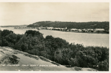
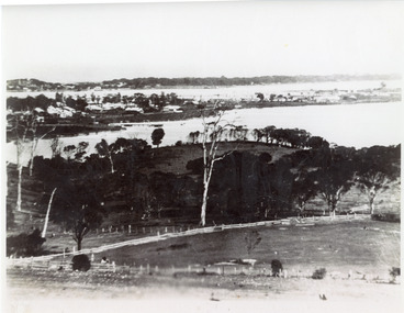
Postcard - Township, 1935c
... south shore of the lake. It shows a panoramic view of Esplanade... a panoramic view of Esplanade and buildings, jetties, Great War ...Black and white small format postcard of town, taken from south shore of the lake. It shows a panoramic view of Esplanade and buildings, jetties, Great War Memorial cypress trees, Jemmys Point and Kalimna Heights in background. Vegetation of sand hummocks in foreground. Lakes Entrance VictoriaThe Township from Ocean Beach Lakes Entrance No 13memorials, vegetation, waterfront, township -
 Eltham District Historical Society Inc
Slide, Shire of Eltham War Memorial Tower, Eltham-Yarra Glen Road, Kangaroo Ground, 24 Jul 1973
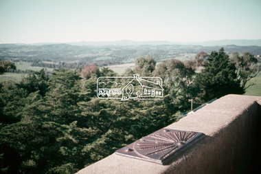
... Various views from each side of the tower lookout... melbourne Various views from each side of the tower lookout ...Various views from each side of the tower lookout. The Memorial Park and Shire of Eltham War Memorial tower are sited at was once known as Garden Hill and was reknowned for its panoramic views it offered tourists from the 1880s on. It was claimed that the full extent of the former Shire of Eltham could be looked upon from this viewpoint - and extending beyond.35 mm colour positive transparency x 7 Mount - Agfacolor Service (Blue)kangaroo ground, shire of eltham, war memorial tower, eltham-yarra glen road, shire of eltham war memorial -
 Lakes Entrance Historical Society
Photograph - Lakes Entrance, 1935c
... hand side on Butchers paddock in the panoramic views, the right... hand side on Butchers paddock in the panoramic views, the right ...Enlarged from postcard produced for Mrs Allen to advertise Allen's Tearoom at the brow of Myer St hill, known as Allen's Hill to locals.|This is the paired before photograph showing the left hand side on Butchers paddock in the panoramic views, the right hand side number 01715. This photograph used in the 150 year Lakes Entrance 1858-2008 display.Black and white photograph of the township, taken from Allen's Hill, Myer St. It shows the town between Cunninghame Arm and North Arm, cleared and fenced paddocks in foreground, New Works village and sand hummocks in distance. Lakes Entrance Victoria township, waterways, topography -
 Ringwood and District Historical Society
Photographs, Construction Stage of historical Miner's Cottage Museum completed 1983, and panoramic view of partial construction of commercial buildings on former Ringwood Market site, Seymour Street, Ringwood c.1970s. On cardboard
... completed 1983, and panoramic view of partial construction of... panoramic view of partial construction of commercial buildings... on cardboard 85.5cmX22.5cm forming panoramic view of partial ...3964/1 15 photographs on cardboard 76cmX51cm depicting construction stages of historical Miner's Cottage Museum completed 1983; 3964/2 4 photographs on cardboard 85.5cmX22.5cm forming panoramic view of partial construction of commercial buildings on former Ringwood Market site, Seymour Street, Ringwood c.1970s -
 Bendigo Historical Society Inc.
Book - GOLDEN BENDIGO
... Golden Bendigo the Forest City, panoramic view of Pall Mall... City, panoramic view of Pall Mall Bendigo and other ...Golden Bendigo the Forest City, panoramic view of Pall Mall Bendigo and other photographic reproductions of views of the city. Printed and published by the Cambridge Press Bendigo Vic. Name on cover, Mr. A.S.Chambers Happy Valley Ravensthorpe WA Wide format booklet; paper with black and white panoramic photos of Bendigo.books, collections, photographs, bendigo -
 Clunes Museum
Photograph
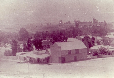
... .1 BLACK AND WHITE PHOTOGRAPH PANORAMIC VIEW FROM BAILEY... BLACK AND WHITE PHOTOGRAPH PANORAMIC VIEW FROM BAILEY STREET ...ORIGINAL PHOTOGRAPH ON LOAN FOR COPYING FROM MRS. MARSHALLSEA..1 BLACK AND WHITE PHOTOGRAPH PANORAMIC VIEW FROM BAILEY STREET CLUNES LOOKING NORTH TOWARDS CLUNES HIGHER ELEMENTARY SCHOOL NO 1552, CANTERBURY STREET. TURNBULL'S PRODUCE STORE IN FOREGROUND CORNER BAILEY AND TEMPLETON STREET. .2 .3 BLACK AND WHITE COPIES OF THE ABOVE PHOTOGRAPH PRINTED ON GLOSS PHOTOGRAPHIC PAPERphotography, shops turnbulls produce store, buildings -
 Ringwood and District Historical Society
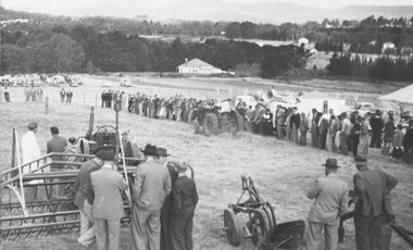
Photograph, Ford Industry Field Day - Loughnan's Hill, Ringwood - April, 1952
... Industry comes to Ringwood. Panoramic view of field day organised.... Panoramic view of field day organised and arranged by Allan Coffey ...Black and white photographWritten on backing sheet- "Mail 10 April 1952. Ford Industry comes to Ringwood. Panoramic view of field day organised and arranged by Allan Coffey Motors showing tractors in operation slashing grass." Included with image- Copy of article in Ringwood Mail dated April 10, 1952,agriculture -
 Kew Historical Society Inc
Plan - Subdivision Plan, Pointed Firs Estate, 1936
... to show the panoramic views from the Estate. A prospective... uses a photograph to show the panoramic views from the Estate ...The Kew Historical Society collection includes almost 100 subdivision plans pertaining to suburbs of the City of Melbourne. Most of these are of Kew, Kew East or Studley Park, although a smaller number are plans of Camberwell, Deepdene, Balwyn and Hawthorn. It is believed that the majority of the plans were gifted to the Society by persons connected with the real estate firm - J. R. Mathers and McMillan, 136 Cotham Road, Kew. The Plans in the collection are rarely in pristine form, being working plans on which the agent would write notes and record lots sold and the prices of these. The subdivision plans are historically significant examples of the growth of urban Melbourne from the beginning of the 20th Century up until the 1980s. A number of the plans are double-sided and often include a photograph on the reverse. A number of the latter are by noted photographers such as J.E. Barnes.An almost identical plan of the ‘Pointed Firs Estate’ is in the State Library of Victoria. The plan unusually uses a photograph to show the panoramic views from the Estate. A prospective purchaser could expect to look across the Yarra Valley to Eaglemont and Heidelberg. The 36 lots advertised for sale faced Doncaster Road, Houghton Street, Maud Street and Thackray Street in Balwyn North.subdivision plans - balwyn, pointed firs estate -
 Kew Historical Society Inc
Photograph - Studley Park (Kew), c.1949
... Small black and white photograph of a panoramic view from...) -1930s Small black and white photograph of a panoramic view from ...An item forming part of a collection of costumes, photographs and documents relating to the Weir family who lived in a mansion, originally named Illapa, at 84 Princess Street, Kew, from c.1917 to 1950. This historically significant collection includes items relating to both George Weir (1866-1937), his wife Edith Mary Weir (1867-1948) and their children. George Weir attained national prominence in the mining industry, becoming General Manager of the North Broken Hill Silver Mining Company in 1903 (later renamed North Broken Hill Mining Company 1905-12, and North Broken Hill Ltd 1912-1988), and subsequently President of the Mine Owners Association. He was to remain General Manager of North Broken Hill Ltd until his retirement in 1926.Small black and white photograph of a panoramic view from the tower of 84 Princess Street, Kew during the occupation of the house by the Weir family during the years 1918-1950. The house and garden had formerly been named Illapa and then Parcnacilla. In 1950 the family sold the house to a religious order who renamed the house 'The Towers'. It now forms part of 'Rylands'.illapa -- 84 princess street -- kew (vic.), aerial photographs -- kew (vic.), studley park (kew) -1930s -
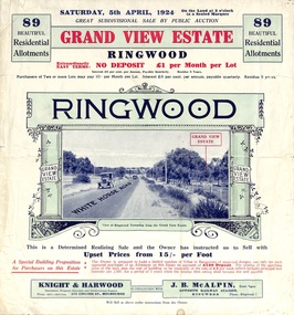 Ringwood and District Historical Society
Flyer, Subdivisional Land Auction Sale Brochure, Grand Central Estate, Ringwood, Vic. - 1924
... . Includes panoramic view over the estate and other local... of the estate. Includes panoramic view over the estate and other local ...Refer also to Reg. No. 5148 for 1925 auction sale of land also titled Grand View Estate situated further south in Ringwood.Double sided multi-folded page advertising public auction sale on Saturday, 5th April, 1924, of residential allotments highlighting local facilities, services and layout of the estate. Includes panoramic view over the estate and other local photographic images. Additional clipped copy of subdivison map on blue cardboard backing includes real estate sales notations.Subdivision includes Whitehorse Road, Rupert Street, Herbert Street. and Leonard Street. Agents - Knight & Harwood, 315 Collins Street, Melbourne, Phone 10615, 10616 Central, in conjunction with J.B. McAlpin, Opposite Railway Station, Ringwood. Phone Ringwood 7. -
 Glenelg Shire Council Cultural Collection
Print, Portland Pier, 1983
... Screenprint depicting a panoramic view of Portland Harbour...) Screenprint depicting a panoramic view of Portland Harbour ...CEMA Art Collection Part of "A Community View" 150 years in Portland Screenprint Exhibition. Part of Angela Gee Residency 1983 and 1984.Screenprint depicting a panoramic view of Portland Harbour and coastline in lower half. Top half of work features five enlarged sea creatures on a yellow background. The creatures are (from left to right): two seahorses; a side view of a fish; a bug; and a front view of a fish. Mounted on yellow matt with purple highlight and sage edging. Wooden and gold frame with glass glazingFront: Portland Pier 30/70 (lower left) A Gee 83 (lower right) (pencil)femal artists, female artist, angela gee, portland screenprint, portland bay press, 150 years, 150th anniversary, 1984 -
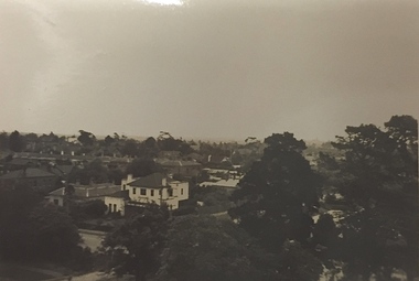
 Ringwood and District Historical Society
Photograph, View from where Heatherdale railway station is now situated, looking towards Ringwood - 2/2/1924. Land between Heatherdale Rd. and Madden St., sold 2nd Feb. 1924. J.B. McAlpin - agent"
... Typed at bottom of photograph, "Panoramic view of Ringwood..., "Panoramic view of Ringwood and the mountains, from Heatherdale ...Typed at bottom of photograph, "Panoramic view of Ringwood and the mountains, from Heatherdale Station Estate". Typed below photograph on mounting sheet, "View from where Heatherdale railway station is now looking towards Ringwood - 2/2/1924". "Between Heatherdale Rd. and Madden St., sold 2nd Feb. 1924. J.B. McAlpin - agent". -
 Federation University Historical Collection
Photograph, Ballarat Looking Towards the Wesleyan Church
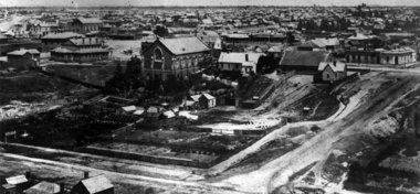
... Panoramic view of Lydiard Street South in Ballarat from... street wesleyan church c.smith nursery Panoramic view of Lydiard ...Panoramic view of Lydiard Street South in Ballarat from the intersection of Lydiard Street and Dana Street. The view shows the former Ballarat Supreme Court (later the Ballarat School of Mines), the Lydiard Street Wesleyan Church (later the Ballarat School of Mines Museum), the site of the Ballarat School of Mines Botanical Gardens, George Smith's Nursery, Ballarat Gaol. Details of the image are also depicted.ballarat school of mines, ballarat gaol, ballarat school of mines museum, ballarat school of mines botanical gardens, george smith, museum, ballarat wesleyan church, ballarat methodist church, lydiard street wesleyan church, c.smith nursery -
Port Melbourne Historical & Preservation Society
Sign, Alison KELLY, Vintage Port Worth Preserving, c.. 1984
... has copies of two panoramic views from the late 1900's which... it to be hung. The reverse side has copies of two panoramic views from ...Sign believed to have been made c.1984 as part of the campaign against amalgamation. Large oblong sign with 'Vintage Port' in white and "Worth Preserving' in red on a blue background. Top left has an image of a red topped shipping beacon. The sign has eyelet holes an each corner & in the centre to enable it to be hung. The reverse side has copies of two panoramic views from the late 1900's which were added at a later date & show the view from Station Pier to the city & the reverse.built environment - industrial, built environment - domestic, centenary bridge, commonwealth government engine works, beacon, piers and wharves - princes pier, piers and wharves - station pier, amalgamation -
![Painting: Park Street [Adeney Avenue] Kew](/media/collectors/550653872162f11fb04854aa/items/5826877cd0cdd11284ad5413/item-media/614ac683a53a0756fd5e49da/item-fit-380x285.jpg) Kew Historical Society Inc
Kew Historical Society IncPainting, Park Street [Adeney Avenue] Kew, c. 1896
... Oil on canvas by an unidentified artist of a panoramic view... on canvas by an unidentified artist of a panoramic view depicting ...‘Adeney Avenue’ was the title given to this painting following its donation to the Kew Historical Society, yet the work’s origins predate the naming of Adeney Avenue in 1907 [originally gazetted as ‘Park Street’ (1865) and ‘Park Street South’ (1875).] Park Street ran between High Street and Parkhill Road beside what was later to become ‘Victoria Park’. This area was described in 1851 as “…a dense forest of gums and wattles which were to be largely cleared by 1888 after the naming of a recreation reserve”. The Reserve was still bisected by an unnamed creek in 1896, when the area was surveyed by the MMBW. The panoramic vista selected by the artist would appear to include ‘Eborensis’ (c.1895) on the corner of Parkhill Road and what was then Park Street, with views across cleared land towards the distant ranges. In the 19th century, north Kew was largely undeveloped farms stretching down to the Yarra. Oil on canvas by an unidentified artist of a panoramic view depicting what is now known as East Kew with mountains on the horizon. In the foreground is a two storey brick residence - Eborensis - located on the northeast corner of Parkhill Road and what is now Adeney Avenue. The view of the landscape and its rolling hills resulted from farming practices adopted following colonisation and settlement. Trees in the foreground and in the distance include remnant Eucalypts and introduced exotics.Label on rear of frame states "House on corner of Adeney Ave & Parkhill. [Regd. 254"]. Otherwise unsigned and undatedadeney avenue (kew), eborensis, park street (kew) -
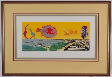
 Glenelg Shire Council Cultural Collection
Artwork, other - Illustration Portland Barton's Beach, n.d
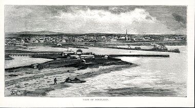
... , looking north west. Panoramic view in background of Portland's... north west. Panoramic view in background of Portland's town ...Illustration. Taken and cut from a book. Black and White rectangle image on off white paper. Portland from Barton's Beach, looking north west. Panoramic view in background of Portland's town with original buildings. All Saints Catholic Church with spire recognisable. Pier in the Middle right with various structures and a docked ship with sails. Bottom left 3 people launching two canoes at the beach. Wattle Creek or Salt Creek with bridge structure on the middle left. Front: 'VIEW OF PORTLAND' - printed, bottom frame. Signature 2cm in from the left corner of the frame 'CALVERT. SS'portland, bartons beach, portland bay -
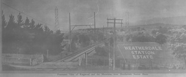
 Ringwood and District Historical Society
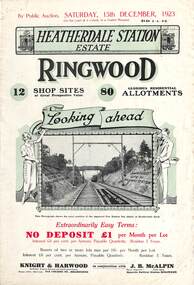
Flyer, Subdivisional Land Auction Sale Brochures, Heatherdale Station Estate, Ringwood, Vic. - 1923 and 1924
... Heatherdale railway station and a panoramic view of Ringwood from... Heatherdale railway station and a panoramic view of Ringwood from ...Two double sided multi-folded pages advertising public auction sales of shop sites and residential allotments on Saturday, 15th December, 1923 and Saturday, 2nd February, 1924, including summary of local facilities, services and map showing layout of the estate. Includes a photograph depicting proposed site for first Heatherdale railway station and a panoramic view of Ringwood from the railway level crossing in Heatherdale Road. 1923 and 1924 flyers are identical except for the auction dates printed at the top.Subdivision includes Heatherdale Road, Molan Street, Yallourn Parade, Newman Street, and Madden Street. Agents - Knight & Harwood, 315 Collins Street, Melbourne, Phone 10615, 10616 Central, in conjunction with J.B. McAlpin, Opposite Railway Station, Ringwood. Phone Ringwood 7. Additional cardboard-backed copy of map includes later penciled sales notations for some blocks (VC 5801 refers). -
 Ringwood and District Historical Society
Photograph, View from Canterbury Road/Balfour Avenue area overlooking Martell's orchard, Heathmont, 1929
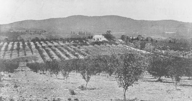
... Typed below photograph, "Panoramic view taken on the estate..., "Panoramic view taken on the estate". "View overlooking Martell's ...Black and white photograph of orchard. House in middle range, mountains in background. Photograph appears to be reproduced from subdivisional brochure. Note inserted in sleeve reads, "It has been pointed out that the mountains are to the east and the view is looking south. This therefore is not a 'straight' photograph. House still exists in Eden Avenue at October, 1996".(3 copies).Typed below photograph, "Panoramic view taken on the estate". "View overlooking Martell's orchard, Heathmont, 1929". Taken from corner Canterbury Rd. and Balfour Ave. looking south. Dandenong Creek just beyond house. Washusen Rd. on right". Written on back of one of the copies, "Heathmont Station Estate 1922". "Station Street, Lisgoold St. Canterbury Rd. Vivienne Cres. Balfour Ave." -
 Eltham District Historical Society Inc
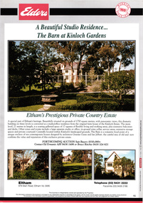
Document, Prospectus: Kinloch Gardens, Eltham Victoria, 1998c
... panoramic views in all directions.” “Kinloch Gardens lies hidden... panoramic views in all directions.” “Kinloch Gardens lies hidden ...“Kinloch Gardens at Eltham, Victoria is planned as a comprehensively designed and cohesive residential environment.” “Only twelve innovatively designed houses ,will be situated within the established gardens and grounds of this historic Eltham estate. Building design and development will be under the control of the Kinloch Gardens design and construction team.” “Kinloch Gardens is situated on one of the highest points in Eltham and enjoys panoramic views in all directions.” “Kinloch Gardens lies hidden from the outside world behind high stone retaining walls, terraced embankments and extensive landscaping. The existing buildings, amongst the most significant of the Eltham / Montsalvat domestic building tradition are set in park like surrounds and enjoy panoramic views of the ranges to the north east and the city sky line to the west. New houses combined with sensitive landscaping will blend immediately into the established garden environment and will share the amenity and ambience of a very private and unique estate. The central theme of the landscape master plan is a garden reserve and a planted avenue terminating in a -small square.” “Houses vary in size from 120m2 (12.9 squares) to 210m2 (22.6 squares) (or larger) and include an extensive range of planning options. House types include: The Studio House The Tower House The Pergola House The Gallery House 'The Barn' is one of the existing buildings of Kinloch Gardens and is situated on the premium Lot 11.” Developer: Kinloch Pty Ltd. Project Managers: Creative Block Design Pty Ltd. Architects: Graeme Gunn and Ian Jelbart. Landscape Architect: Suzy Boyd. Builder: Vizarje Homes Pty Ltd. Surveyors and Engineers: Miller Merrigan.Digital file only; created from scan undertaken by EDHSarthur street, creative block design pty ltd., eltham, graeme gunn, houses, ian jelbart, kinloch gardens, kinloch pty ltd, miller merrigan, real estate, suzy boyd, vizarje homes pty ltd. -
 Eltham District Historical Society Inc
Document, Kinloch Gardens Property Album; Elders Real Estate sales material, 1998
... panoramic views in all directions.” “Kinloch Gardens lies hidden... panoramic views in all directions.” “Kinloch Gardens lies hidden ...“Kinloch Gardens at Eltham, Victoria is planned as a comprehensively designed and cohesive residential environment.” “Only twelve innovatively designed houses ,will be situated within the established gardens and grounds of this historic Eltham estate. Building design and development will be under the control of the Kinloch Gardens design and construction team.” “Kinloch Gardens is situated on one of the highest points in Eltham and enjoys panoramic views in all directions.” “Kinloch Gardens lies hidden from the outside world behind high stone retaining walls, terraced embankments and extensive landscaping. The existing buildings, amongst the most significant of the Eltham / Montsalvat domestic building tradition are set in park like surrounds and enjoy panoramic views of the ranges to the north east and the city sky line to the west. New houses combined with sensitive landscaping will blend immediately into the established garden environment and will share the amenity and ambience of a very private and unique estate. The central theme of the landscape master plan is a garden reserve and a planted avenue terminating in a -small square.” “Houses vary in size from 120m2 (12.9 squares) to 210m2 (22.6 squares) (or larger) and include an extensive range of planning options. House types include: The Studio House The Tower House The Pergola House The Gallery House 'The Barn' is one of the existing buildings of Kinloch Gardens and is situated on the premium Lot 11.” Developer: Kinloch Pty Ltd. Project Managers: Creative Block Design Pty Ltd. Architects: Graeme Gunn and Ian Jelbart. Landscape Architect: Suzy Boyd. Builder: Vizarje Homes Pty Ltd. Surveyors and Engineers: Miller Merrigan.Digital file only; created from scan undertaken by EDHSarthur street, elders real estate, eltham, kinloch gardens, real estate agent, the barn -
 Melbourne Tram Museum
Map, Victour, "Melbourne Holiday City", c1975
... , The Victorian Government Tourist Bureau, a panoramic view of Melbourne... Government Tourist Bureau, a panoramic view of Melbourne and a large ...Map - 12 fold special size - full colour titled "Melbourne Holiday City", published by Melbourne Tourism, c1975 prior to the construction of East Burwood tram line, providing a list of amusements, tourist locations, places of interest, map provided by Victour, The Victorian Government Tourist Bureau, a panoramic view of Melbourne and a large map of Melbourne and suburbs showing rail, bus and tram lines and key to suburbs. Cover photo with 882 (Route 11, Spencer St) in Collins St looking west with the Westgate bridge in the far background.trams, tramways, map, public transport, city of melbourne, buses, railways, tramways, victour, tram 882 -
 Eltham District Historical Society Inc
Document - Brochure, The Barn at Kinloch Gardens; Elders Real Estate sales material, 1998
... situated on grounds of 1750 square metres with panoramic views... situated on grounds of 1750 square metres with panoramic views ...Description by Elders Real Estate: A Beautiful Studio Residence: The Barn at Kinloch Gardens Eltham's prestigious Private Country Estate A special part of Eltham's heritage. Beautifully situated on grounds of 1750 square metres with panoramic views, this dramatic building on three levels is converted to a ? office residence from the original farm house of the Kinloch Estate. The main level, 21 metres in length, is a soaring galleried space of 17 squares of flexible living and working areas, extensive storage spaces and private courtyard. Centrally located within Kinloch's landscaped grounds. The Barn is a romantic focal point of a unique enclave of ten contemporary house designed by Graeme Gunn and Ian Jelbart, the cultural mix of old and new confirms the value and reputation of this exclusive private estate. Digital file only; created from scan undertaken by EDHS of item on loanarthur street, elders real estate, eltham, houses, jelbart property, kinloch gardens, real estate agent, the barn, woodridge estate -
 Marysville & District Historical Society
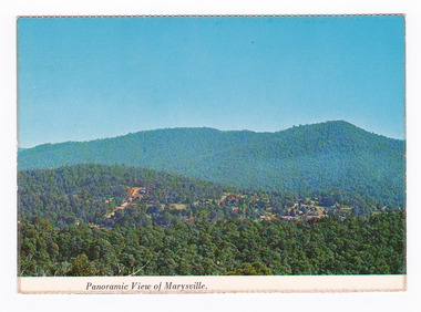
Postcard (item) - Colour postcard, Nucolorvue Productions Pty. Ltd, Panoramic View of Marysville, Pre 2009
... Panoramic View of Marysville....NU-COLOR-VUE/ OF/ AUSTRALIA MARYSVILLE, VICTORIA Panoramic... in Victoria. Panoramic View of Marysville. Postcard Colour postcard ...A colour photograph of the view of Marysville from Barton's Lookout which is near the Cumberland Valley in Victoria.A colour photograph of the view of Marysville from Barton's Lookout which is near the Cumberland Valley in Victoria. The Cumberland Valley is notable for its giant mountain ash (Eucalyptus regnans) trees within the Cumberland Memorial Scenic Reserve, and relics from former sawmills and gold mining. The Big Culvert is located nearby on the Marysville-Woods Point Road, which was historically part of the Yarra Track. Cambarville, which is in the Cumberland Valley, was established as a timber mill town in the 1940s. Timber mill owners A Cameron and FJ Barton named Cambarville. They established the mill to salvage timber from trees destroyed in the 1939 bushfires. Cambarville was impacted by the 2009 Black Saturday bushfires and any remaining structures were destroyed. Barton's Lookout was named after a member of the Barton Family who were amongst Marysville's earliest pioneering families. This postcard was produced by Nucolorvue Productions as a souvenir of Marysville.NU-COLOR-VUE/ OF/ AUSTRALIA MARYSVILLE, VICTORIA Panoramic View of Marysville from/ CUMBERLAND. PLACE/ STAMP/ HERE POST CARD NUC.171 - NUCOLORVUE PRODUCTIONS PTY. LTD./ COPYRIGHT Printed in Australia Hi There! how are you? fine I hope....Hows school/ treating you?/ Isn't it beautiful now Autumns back again./ You'll have to come up soon and see us, where/ really you/ Ok! it beautiful, the air so fresh and/ clean it makes you want to cry. There are/ so many magnificent and brill marysville, barton's lookout, victoria, nucolorvue productions, postcard, souvenir, cumberland valley, cumberland memorial scenic reserve, big culvert, marysville-wood's point road, yarra track, mining, timber mills, a cameron, fj barton, cambarville, 1939 bushfires, 2009 black saturday bushfires -
 Kew Historical Society Inc
Photograph - Victorian Canoe Club, V.C.C. site, Studley Park, 1920-30
... as 'V.C.C. site, Studley Park'.The panoramic view shows a number.... site, Studley Park'.The panoramic view shows a number ...Canoeing on the River Yarra at Melbourne was an important and widespread recreational pursuit for Melbournians, especially in the first half of the twentieth century. The Victorian Canoe Club was formed in 1912 at a meeting in Melbourne and its first committee elected in the same year. Records indicate that the Club continued into at least the 1950s .The album has historic and social significance as a record of recreational activities (as well as canoe making) in the early years of the twentieth century. It has local significance as the site of the headquarters of the Club was in Studley Park. A number of photographs in the album provide vistas of Kew on the Yarra that are otherwise unavailable.One of 24 labelled photos in part album, originating from the Victorian Canoe Club, which had its headquarters in Studley Park, Kew. The album includes a photographic record of canoe construction and also locations in Studley Park and Kew where the canoes were used. The subject of this photograph is identified as 'V.C.C. site, Studley Park'.The panoramic view shows a number of important landmarks during this period. On the left of the photograph is one of the remaining buildings of the Yarra Bend Asylum. Stretching across the river is a suspension bridge on the site of the present Kane's Bridge. The reference to the V.C.C. site is unclear within the context of the photo which appears to be taken from the vicinity of the Johnston Street Bridge."V.C.C. site, Studley Park"victorian canoe club, river yarra, canoe clubs, yarra bend asylum, suspension bridge -- kew, kane's bridge, studley park -
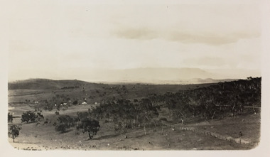 Kew Historical Society Inc
Photograph - Farms near Omeo, c.1926
... is a panoramic view farmland near Omeo in Victoria.... black and white photo is a panoramic view farmland near Omeo ...Henry Beater Christian (1886-1962) , was a descendant of one of the earliest settler families in Kew. Employed at the Kew Asylum as a 'public servant', he was a skilled amateur photographer, photographing numerous scenes in Kew and on his travels around Victoria. The majority of his photographs date from 1916 to 1929. His finest photographs are housed in two photograph albums. Digital copy of a photograph from page 33 of the 47-page photograph album containing 261 gelatinous silver images, loaned by Diane Washfold with permission given to digitise and hold a copy in our collection. John Chapman has written in 'Bushwalking Clubs - A Brief History', about the establishment in Victoria of the first bushwalking club in 1888, and the popularisation of bushwalking during the interwar period. Henry Christian's 'walks' appear to have been undertaken solely or with a companion/s. This black and white photo is part of a group of photos taken in the Victorian High Country. The page is labelled 'Omeo' and includes photos of landscapes, individuals, and towns. This small black and white photo is a panoramic view farmland near Omeo in Victoria."OMEO"henry beater christian (1886-1962), landscape photography, christian-washfold collection, photograph albums, bushwalking, northeast victoria, victorian high country, omeo -
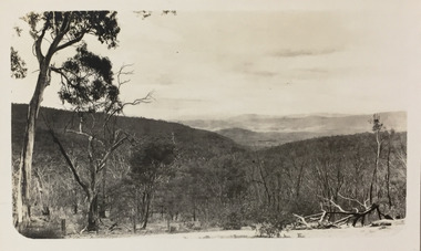 Kew Historical Society Inc
Photograph - Victorian High Country, c.1926
... is a panoramic view of mountains and valleys stretching off... black and white photo is a panoramic view of mountains ...Henry Beater Christian (1886-1962) , was a descendant of one of the earliest settler families in Kew. Employed at the Kew Asylum as a 'public servant', he was a skilled amateur photographer, photographing numerous scenes in Kew and on his travels around Victoria. The majority of his photographs date from 1916 to 1929. His finest photographs are housed in two photograph albums. Digital copy of a photograph from page 33 of the 47-page photograph album containing 261 gelatinous silver images, loaned by Diane Washfold with permission given to digitise and hold a copy in our collection. John Chapman has written in 'Bushwalking Clubs - A Brief History', about the establishment in Victoria of the first bushwalking club in 1888, and the popularisation of bushwalking during the interwar period. Henry Christian's 'walks' appear to have been undertaken solely or with a companion/s. This black and white photo is part of a group of photos taken in the Victorian High Country. The page is labelled 'Omeo' and includes photos of landscapes, individuals, and towns. This small black and white photo is a panoramic view of mountains and valleys stretching off into the distance."OMEO"henry beater christian (1886-1962), landscape photography, christian-washfold collection, photograph albums, bushwalking, northeast victoria, victorian high country, omeo -
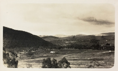 Kew Historical Society Inc
Photograph - Omeo, c.1926
... is a panoramic view of Omeo in Victoria, which is surrounded by farmland... black and white photo is a panoramic view of Omeo in Victoria ...Henry Beater Christian (1886-1962) , was a descendant of one of the earliest settler families in Kew. Employed at the Kew Asylum as a 'public servant', he was a skilled amateur photographer, photographing numerous scenes in Kew and on his travels around Victoria. The majority of his photographs date from 1916 to 1929. His finest photographs are housed in two photograph albums. Digital copy of a photograph from page 33 of the 47-page photograph album containing 261 gelatinous silver images, loaned by Diane Washfold with permission given to digitise and hold a copy in our collection. John Chapman has written in 'Bushwalking Clubs - A Brief History', about the establishment in Victoria of the first bushwalking club in 1888, and the popularisation of bushwalking during the interwar period. Henry Christian's 'walks' appear to have been undertaken solely or with a companion/s. This black and white photo is part of a group of photos taken in the Victorian High Country. The page is labelled 'Omeo' and includes photos of landscapes, individuals, and towns. This small black and white photo is a panoramic view of Omeo in Victoria, which is surrounded by farmland, mountains and valleys."OMEO"henry beater christian (1886-1962), landscape photography, christian-washfold collection, photograph albums, bushwalking, northeast victoria, victorian high country, omeo -
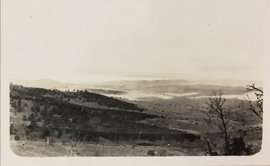 Kew Historical Society Inc
Photograph - Rolling hills near Omeo, c.1926
... is a panoramic view of valleys and hills near Omeo in Victoria in the mid... black and white photo is a panoramic view of valleys and hills ...Henry Beater Christian (1886-1962) , was a descendant of one of the earliest settler families in Kew. Employed at the Kew Asylum as a 'public servant', he was a skilled amateur photographer, photographing numerous scenes in Kew and on his travels around Victoria. The majority of his photographs date from 1916 to 1929. His finest photographs are housed in two photograph albums. Digital copy of a photograph from page 33 of the 47-page photograph album containing 261 gelatinous silver images, loaned by Diane Washfold with permission given to digitise and hold a copy in our collection. John Chapman has written in 'Bushwalking Clubs - A Brief History', about the establishment in Victoria of the first bushwalking club in 1888, and the popularisation of bushwalking during the interwar period. Henry Christian's 'walks' appear to have been undertaken solely or with a companion/s. This black and white photo is part of a group of photos taken in the Victorian High Country. The page is labelled 'Omeo' and includes photos of landscapes, individuals, and towns. This small black and white photo is a panoramic view of valleys and hills near Omeo in Victoria in the mid-1920s."OMEO"henry beater christian (1886-1962), landscape photography, christian-washfold collection, photograph albums, bushwalking, northeast victoria, victorian high country, omeo