Showing 2288 items matching "parishes"
-
 Bendigo Historical Society Inc.
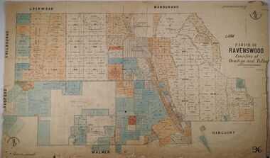
Map - PARISH OF RAVENSWOOD, 3/04/1875
Map: Parish of Ravenswood, Counties of Bendigo and Talbot. Parish planmap, bendigo, parish plan, ravenswood, county of talbot, county of bendigo -
 Bendigo Historical Society Inc.
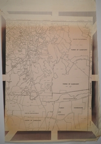
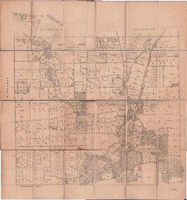
Map - CAMPBELL COLLECTION: BENDIGO AND DISTRICT MAPS
Map. Parish of Sandhurst, Shire of Strathfieldsaye, Mandurang Parish, Junortoun.map, bendigo, city streets -
 Whitehorse Historical Society Inc.
Document, Certificate of Title, 1915, 1933
Certificate of Title, Frederick William GibbonsCertificate of Title, Frederick William Gibbons, Lot 88, Subdivision 1968, part of crown allotment 1270, Parish of Nunawading, County of Bourke 1915. Vol 3882, fol 776385 also correspondence re rates, enforcement of charge, 1933.Certificate of Title, Frederick William Gibbonsland titles, shire of blackburn and mitcham, gibbons, frederick william, shire of nunawading, burnett street, mitcham, gort road, mitcham -
 Linton and District Historical Society Inc
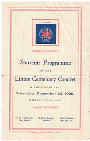
Programme - Souvenir Programme, Souvenir Programme of the Linton Centenary Concert, 1939
Programme consists of a single sheet of cream-coloured paper, folded in two. Front of programme has a border of red lines and the blue and red logo for the Linton Centenary. The back of the programme has the words of two songs performed during the concert: "Linton's the Place for Me", and "The A.I.F. of 1939". Full concert programme printed inside fold. Concert held as part of Linton centenary celebrations on Saturday December 23, 1939, in the Linton Parish Hall (Church of England Hall). Text,: ' Souvenir Programme / OF THE / Linton Centenary Concert / IN THE PARISH HALL / Saturday, December 23, 1939. / COMMENCING AT 8 P.M. 'centenary celebrations, centenaries, concerts, entertainment, linton -
 Ringwood and District Historical Society
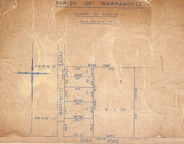
Map, Subdivision Plan of 5 residential allotments on Warrandyte Road and Oban Road, Ringwood, Victoria - (Undated - pre 1950s)
Partial copy of Crown Allotment Map on cardboard backingParish of Warrandyte, County of Evelyn. -
 Bendigo Historical Society Inc.
Map - JACK FLYNN COLLECTION: TARNAGULLA SHEET 3, No date visible
Map: Parish of Tarnagulla Sheet 3, County of Gladstone. Parish plan.map, gladstone, parish plan, tarnagulla sheet 3 -
 Bendigo Historical Society Inc.
Map - JACK FLYNN COLLECTION: TOWNSHIP OF STANHOPE, December 1950
Map: Township of Stanhope, Parish of Girgarre, County of Rodney. Parish plan.By Authority J. J. Gourley, Government Printer, Melbourne. Drawn and Reproduced at the Dept, of Lands and Survey, Melbourne, Victoria.map, rodney, township, stanhope -
 Bendigo Historical Society Inc.
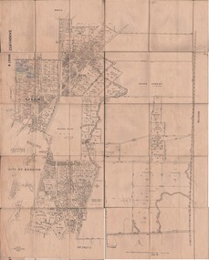
Map - JACK FLYNN COLLECTION: SANDHURST SHEET 6, January 1947
Map: Parish of Sandhurst Sheet 6. County of Bendigo. Parish plan.By Authority J. J. Gourley, Government Printer, Melbourne. Drawn and Reproduced at the Dept, of Lands and Survey, Melbourne, Victoria.map, bendigo, parish plan, sandhurst sheet 6 -
 Bendigo Historical Society Inc.
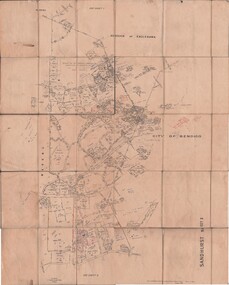
Map - JACK FLYNN COLLECTION: SANDHURST SHEET 2, January 1947
Map: Parish of Sandhurst Sheet 2, County of Bendigo. Parish plan.By Authority J. J. Gourley, Government Printer, Melbourne. Drawn and Reproduced at the Dept, of Lands and Survey, Melbourne, Victoria.map, bendigo, parish plan, sandhurst sheet 2 -
 Bendigo Historical Society Inc.
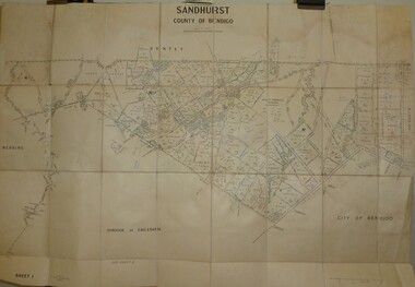
Map - JACK FLYNN COLLECTION: SANDHURST SHEET 1, January 1947
Map: Parish of Sandhurst sheet 1, County of Bendigo. Parish plan.map, bendigo, parish plan, sandhurst -
 Bendigo Historical Society Inc.
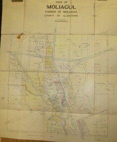
Map - JACK FLYNN COLLECTION: MOLIAGUL, 7/02/1931
Map: Township of Moliagul, Parish of Moliagul, County of Gladstone. Parish plan.map, gladstone, township, moliagul -
 Bendigo Historical Society Inc.
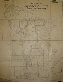
Map - JACK FLYNN COLLECTION: MOLIAGUL, October 1946
Map: Parish of Moliagul, Sheet 1, County of Gladstone. Parish plan.map, gladstone, parish plan, moliagul -
 Bendigo Historical Society Inc.
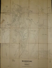
Map - JACK FLYNN COLLECTION: MANDURANG SHEET 2, March 1947
Map: Parish of Mandurang, Sheet 2, County of Bendigo. Parish plan.By Authority J.J.Gourley Government Printer Melbourne. Drawn and Produced at the Dept, of Lands and SurveyMelbourne, Victoria. March 1947.map, bendigo, parish plan, mandurang -
 Bendigo Historical Society Inc.
Map - JACK FLYNN COLLECTION: GIRGARRE, 1957
Map: Township of Girgarre, Parish of Kyabram, County of Rodney. Parish plan.By Authority: W. M. Houston, Government Printer, Melbourne. Drawn and reproduced at the Department of Lands and Survey, Melbourne.map, rodney, township, girgarre -
 Bendigo Historical Society Inc.
Map - JACK FLYNN COLLECTION: BET BET, 18/08/1931
Map: Parish of Bet Bet, Counties of Gladstone and Talbot . Parish plan.By Authority H.J. Green Govt, Printer. Photo Lithographed at the Department of Lands and Survey, Melbourne. 18.8.31map, gladstone, parish plan, bet bet, counties of gladstone and talbot. -
 Bendigo Historical Society Inc.
Map - JACK FLYNN COLLECTION: GOORNONG, August 1953
Map: Township of Goornong, Parish of Goornong, County of Bendigo. Parish plan.By Authority W.M. Houston. Government Printer. Drawn and Reproduced at the Dept., of Lands and Survey, Melbourne, Victoria. August 1953map, bendigo, township, goornong -
 Bendigo Historical Society Inc.
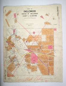
Map - TOWN OF INGLEWOOD, March 1946
Map: Town of Inglewood, Parish of Inglewood, County of Gladstone. Parish planmap, gladstone, township, inglewood -
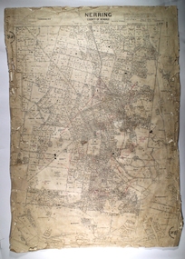 Bendigo Historical Society Inc.
Map - NERRING, 25/08/1903 ?
Map: Parish of Nerring, County of Bendigo. Parish plan Canvas backedmap, bendigo, rural, nerring, county of bendigo -
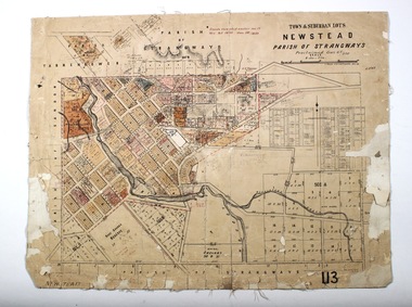 Bendigo Historical Society Inc.
Map - NEWSTEAD, 28/07/1874
Map: Newstead Town and Suburban Lots, Parish of Strangways. Parish planmap, township, newstead -
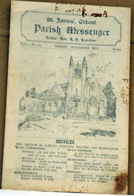 Orbost & District Historical Society
newsletter, St James, Orbost Parish Messenger November, 1933, November 1933
St. James' Anglican Church, Orbost, was conceived and built as a memorial to the men 'who served and suffered during the Great War' as noted on the foundation stone. The Right Reverend GH Cranswick, DD, Bishop of Gippsland, laid the stone on 1 October 1927. This parish newsletter was published regularly to inform church members of all the latest news, events and information.For many years the Anglican people of Orbost have enjoyed the fellowship of the church and the children, in particular, were socially and spiritually involved. This item is reminiscent of the first half of the 20th century when church-going was more common.A four page newsletter titled, Parish Messenger for Orbost, November 1933, Vol 6 -No 83. It lists the services, times, meetings and news. The rector at the time was Rev. K.E. Hamilton.st-james-anglican-church church newsletter -
Whitehorse Historical Society Inc.
Document, Certificate of Title, 1923 - 1934
Certificate of Title, William Arthur Hirst.Certificate of Title, William Arthur Hirst. Lot 20 Subdivision 6626, part of crown allotment 127A at Mitcham, Parish of Nunawading, Count of Bourke. Vol 4671, fol 934063. Also correspondence re rates enforcement charge, 1933-34.Certificate of Title, William Arthur Hirst.land titles, shire of blackburn and mitcham, hirst, william arthur, shire of nunawading, thomas street, mitcham -
Whitehorse Historical Society Inc.
Map, Parish of Nunawading, 1853
Photocopy of manuscript map with allotments numbered and named.Photocopy of manuscript map with allotments numbered and named. Note on verso: Parish of Nunawading, County of Bourke. Gardiners Creek, Ballyshanassey Township, surveyed by H. Parmein, Surveyor General's office, Nov 30th 1853 [enlargement of ND2801, no list of corner references]Photocopy of manuscript map with allotments numbered and named. maps, gardiners creek, ballyshanassy, burwood east, parmein, h -
Whitehorse Historical Society Inc.
Map, The Parish of Nunawading, 1853
Photocopy of manuscript plan with allotments numbered and some named.Photocopy of manuscript plan with allotments numbered and some named. Note on verso: The Parish of Nunawading in the County of Bourke; lithographed at the Surveyor General's office by J.Jones Jan 18th 1853. Endorsed Sale Plan 271. Dray tracks, water holes and terrain indicated.Photocopy of manuscript plan with allotments numbered and some named. land subdivision, maps, parish of nunawading, jones, j -
Whitehorse Historical Society Inc.
Document, Certificate of Title, 1927, 1934
Certificate of Title, State Savings Bank of Victoria.Certificate of Title, State Savings Bank of Victoria. Part of Lot 58, Parish of Nunawading, 13 Oct 1927. Vol 5325 Fol 1064898. Letter of 24 Apr 1934 to Mr R. Bell from Council rate collector asking for arrears.Certificate of Title, State Savings Bank of Victoria.land titles, rates, shire of blackburn and mitcham, bell, r, wolseley crescent, blackburn -
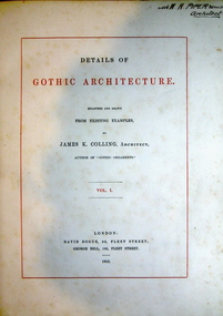 Federation University Historical Collection
Book, Details of Gothic Architecture, 1852 (exact)
“Details of Gothic Architecture is measured and drawn from existing examples by James K. Colling, author of ‘Gothic Ornaments’.“—Front cover. It contains detailed drawings of parish churches during the 19 century.A large book with blue hardcover and black cloth corners and spine. Illus. with b&w plates of architectual drawings. Vol.1. Title is printed in black and red. This book contains measured drawings of details from parish churches. It includes 8p. table of contents. Inscription on title page "W. H. Piper, architect". A plate inside front cover titled "Ballarat Technical Art School Library No. AD/14".and, architecture gothic, decoration, ornament gothic, james k colling, gothic england, norman, early english, decorated, perpendicular, burnby church, etton church, yorkshire, walsoken church, norfolk, great grimsby church, lincolnshire, bookplate, ballarat technical art school library -
 Bendigo Historical Society Inc.
Map - JACK FLYNN COLLECTION: TARNAGULLA SHEET 4, 25/11/1926
Map: Parish of Tarnagulla Sheet 4, Counties of Gladstone and Bendigo. Parish plan.Photo-Lithographed at the Department of lands and Survey, Melbourne by W. J. Butson. 25.11.26map, gladstone, parish plan, tarnagulla sheet 4 -
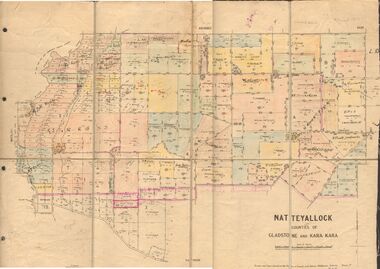 Bendigo Historical Society Inc.
Map - JACK FLYNN COLLECTION: NATTE YALLOCK, 22/06/1937
Map: Parish of Natte Yallock, Counties of Gladstone and Kara Kara. Parish plan.By Authority H.J. Green Government Printer Melbourne. Drawn and Reproduced at the Depart., of Lands and Survey, Melbourne, Victoria.map, gladstone, parish plan, natte yallock -
 Bendigo Historical Society Inc.
Map - JACK FLYNN COLLECTION: LAANACOORIE, No date visible
Map: Parish of Laanacoorie, County of Bendigo. Parish plan. Half of the sheet is missing.By Authority H.J. Green. Govt, Printer.map, bendigo, parish plan, laanacoorie -
 Bendigo Historical Society Inc.
Map - JACK FLYNN COLLECTION: VILLAGE OF BETLEY, 30/06/1874
Map: Village of Betley, on the Bet Bet Creek, Parish of Dunolly. Parish plan.Photo Lithographed at the Department of Lands and Survey Melbourne by J. Noone 30.6.74map, gladstone, village, betley, bet bet creek, dunolly -
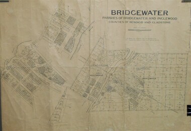 Bendigo Historical Society Inc.
Map - JACK FLYNN COLLECTION: BRIDGEWATER, 10/09/1931
Map: Bridgewater, Parishes of Bridgewater and Inglewood, Counties of Bendigo and Gladstone. Parish plan.map, bendigo, parish plan, bridgewater inglewood