Showing 22258 items
matching parkes
-
 Kew Historical Society Inc
Photograph, J F C Farquhar, Studley Park Road, 1891
At the beginning of the 1890s, the Kew businessman and Town Councillor, Henry Kellett, commissioned J.F.C. Farquhar to photograph scenes of Kew. These scenes included panoramas as well as pastoral scenes. The resulting set of twelve photographs was assembled in an album, Kew Where We Live, from which customers could select images for purchase.The preamble to the album describes that the photographs used the ‘argentic bromide’ process, now more commonly known as the gelatine silver process. This form of dry plate photography allowed for the negatives to be kept for weeks before processing, hence its value in landscape photography. The resulting images were considered to be finely grained and everlasting. Evidence of the success of Henry Kellett’s venture can be seen today, in that some of the photographs are held in national collections.It is believed that the Kew Historical Society’s copy of the Kellett album is unique and that the photographs in the book were the first copies taken from the original plates. It is the first and most important series of images produced about Kew. The individual images have proved essential in identifying buildings and places of heritage value in the district.In this view of Studley Park Road, looking northeast to the Junction, the photographer invites the viewer to participate in a point-of-view that emphasises the elevated, tranquil vantage point of the hill in contrast to the bustling commercial area in the distance. The view emphasises the exclusiveness of Studley Park, with its high fences behind which a number of significant Kew mansions were concealed. Contemporary advertisements for the sale of mansions in Studley Park Road often included fulsome descriptions of their elaborate formal gardens, as well as paddocks for grazing, stabling and dairies. None can be seen here. The use of high, protective wooden pickets to surround the newly planted avenue of elms on the south side of the road appears to be typical of the period. Similar examples can be seen in early photographs of Wellington and Princess Streets.The horse and carriage, selected as a central focus of the view, reinforces the residential, exclusive nature of this part of Kew in the early 1890s. Studley Park Roadkew illustrated, kew where we live, photographic books, henry kellett -
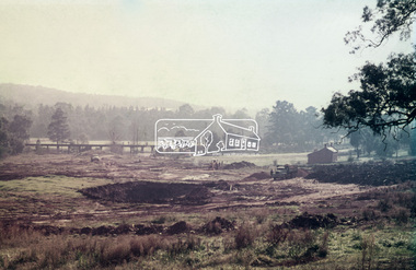 Eltham District Historical Society Inc
Slide, Construction of Eltham Town Park, 25 Jul 1973
Construction of Eltham Town Park; reclamation of the eastern end of the tip overflow and landscape in progress of being sculptured and lakes formed. Shillinglaw Cottage and the Eltham Trestle Bridge visible. The park was later renamed Alistair Knox Park.35 mm colour positive transparency Mount - Agfacolor Service (Blue)Memorial Park 25 July 1973eltham, alistair knox park, eltham town park, shillinglaw cottage, eltham trestle bridge, eltham tip, trestle bridge -
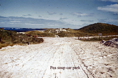 Port Fairy Historical Society Museum and Archives
Photograph - photocopy
Pea soup car parkpea soup car parkpea soup, car park, sand, road, track -
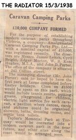 Phillip Island and District Historical Society Inc.
Newspaper clippings
Article on establishment of Company to establish modern Caravan Parks in Victoria, called Amalgamated Caravan Parks Pty Ltd, first Park to be at Lorne. Includes description of intended facilities. A second park to be established at Torquay.Article on establishment of Caravan Parks Company.local history, documents, newspapers, caravan parks, black & white newspaper clipping -
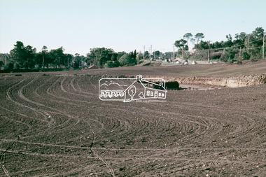 Eltham District Historical Society Inc
Slide, Construction of Eltham Town Park, 25 Jul 1973
Construction of Eltham Town Park; landscape has been scupltured and lakes formed. Shillinglaw Cottage , Main Road, Eltham Shire Council Offices and Catholic Church all visible. The park was later renamed Alistair Knox Park.35 mm colour positive transparency Mount - Agfacolor Service (Blue)Memorial Park 25 July 1973eltham, main road, alistair knox park, eltham town park, shillinglaw cottage, bridge street -
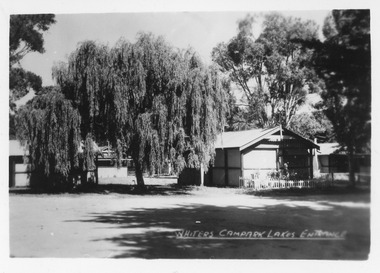
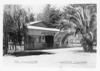 Lakes Entrance Historical Society
Postcard - Whiters Camp Park, Bulmer H D, 1945c
One of a set of eight small format postcardsBlack and white small format postcard of the Homestead at Whiters Camp Park. A fibro cement sheet clad residence of the proprietors family, palm tree at the right hand side. Lakes Entrance VictoriaThe Homestead, Whiters Camp Parkresort, recreation, tourism -
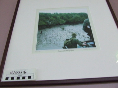 Waverley RSL Sub Branch
Print "Someone had to go first" Vietnam 1970, Someone had to go first
Print in wooden frame under glass "Someone had to go first" Vietnam 1970 Leon Park"Someone had to go first" Vietnam 1970 Leon Parksomeone had to go first, vietnam war, print -
 Glenelg Shire Council Cultural Collection
Photograph - Photograph - Casterton Island Park, c. 1963
Sourced from Casterton Town Hall (Former Shire of Glenelg)Black and white phot. Island Park Casterton, looking across oval to C. R. Gill pavilionBack: 'Island Park Oval Casterton' - handwritten, green biro -
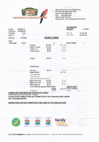 Marysville & District Historical Society
Document (Item) - Receipt, Larry and Margaret Richmond, 2008
A series of documents including a receipt for a deposit paid for a park cabin at the Marysville Caravan & Holiday Park that was issued in 2008.A series of documents including a receipt for a deposit paid for a park cabin at the Marysville Caravan & Holiday Park that was issued in 2008.marysville, victoria, australia, marysville caravan park, accommodation, receipt, marysville caravan & holiday park, emergency procedures, camp fires, park policies -
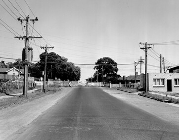 City of Kingston
Photograph - Black and white, Public Transport Corporation, c. 1960
Black and white photograph depicting closed crossing gates at the level crossing at Park Road, Cheltenham. This image is part of a larger collection of images from the Public Transport Corporation displaying train stations and streetscapes in what is now the City of Kingston.Black and white photograph of Cheltenham level crossing at Park Road, Cheltenham. The gates are closed. Stamped in blue ink on reverse: COPYRIGHT / Public Transport Corporation / For re-ordering photographs / Please quote negative No H3052 / Enquiries C/- PTC Photographic Unit / Telephone switchboard 619 111 White paper stuck to reverse of image, with black typed text: Cheltenham Park Road, Cheltenham / 1965 / $50 reproduction fee appliescheltenham, railway crossing, suburbs, public transport -
 Lakes Entrance Historical Society
Postcard - Whiters Camp Park, Bulmer H D, 1945c
One of a set of eight small format postcardsSmall format black and white postcard of Whiters Camp Park, showing two cement sheet buildings, weeping willow tree and other trees. Lakes Entrance VictoriaWhiters Camp Park Lakes Entrancetourism, topography, resort -
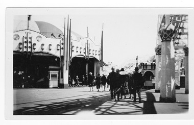 St Kilda Historical Society
Photograph, Luna Park, c. 1900s
Amatuer photogrph, Carousel entrance on left, the backs of a group milling on right, Luna Park, St Kildablack and white photograph, unmounted, fair condition, originalLuna Park - interior -
 Kew Historical Society Inc
Photograph - Street Works, Studley Park Road, March 1934
Studley Park Road, like most streets in Kew, was originally a dirt road. Street works during the Great Depression included bituminising major roads in the district. This photograph of Council works originated in the City of Kew Engineers Department as a record of works undertaken. It was given to the collection by a Mrs Fisher in 1998.Well provenanced photograph of Council-funded public works in Kew during the Great Depression. Original sepia monochrome positive of Council workers standing on and beside a dray in Studley Park Road, Kew while resurfacing of the street was taking place. The Kew Junction is just visible behind the men.Typed reverse: "B4 / Kew C.C. / Spreading premixed material on Studley Park Road with drag spreader, view from rear of machine, March 1934"roadworks -- kew (vic.), street works -- kew (vic.), public works kew (vic.), studley park road -- kew (vic.), city of kew -- engineers department, city of kew -- public works -- great depression -- 1930s -
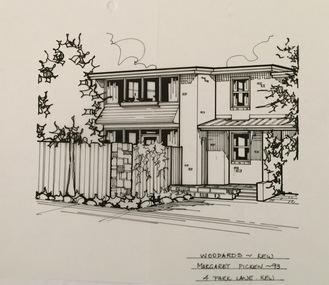 Kew Historical Society Inc
Drawing - Property Illustration, Margaret Picken, 4 Park Lane, Kew, 1993
After training as a Cartographic Draftsman within the mining industry, I worked as a property illustrator for real estate firms in the eastern suburbs of Melbourne for 23 years from 1983. I initially photographed houses with a Polaroid camera and made a 'thumbnail' sketch while there. The photos were used to scale off a sketch in pencil and then that sketch was overlaid with drafting film and the 'pen and ink' completed. The pens I used were the Rotring ‘Rapidigraph’ drafting pens. The ink was also made by Rotring (German).The film was ‘Rapidraw’, polyester drafting film, double matte. It takes a very fine line and doesn’t bleed. As well as house sketches, there were often floor plans and site plans ordered. Aerial sketches were ordered when the property needed an overall view. (Margaret Picken, 2020)This drawing is one of a series created by Margaret Picken for a number of real estate agents in Melbourne between 1983 and 2005. Each work is signed and dated by the artist.Gift of Margaret Picken, 2020Pen and ink architectural drawing on drafting film of 4 Park Lane, Kew by Margaret Picken.WOODARDS ~ KEW / MARGARET PICKEN ~93 / 4 PARK LANE KEWartist -- margaret picken 1950-, architectural drawings -- houses -- kew (vic.), 4 park lane - kew (vic) -
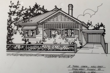
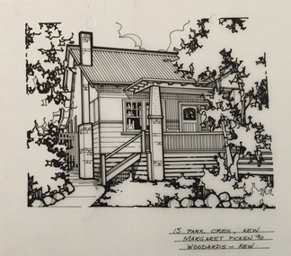 Kew Historical Society Inc
Drawing - Property Illustration, Margaret Picken, 15 Park Crescent, Kew, 1990
After training as a Cartographic Draftsman within the mining industry, I worked as a property illustrator for real estate firms in the eastern suburbs of Melbourne for 23 years from 1983. I initially photographed houses with a Polaroid camera and made a 'thumbnail' sketch while there. The photos were used to scale off a sketch in pencil and then that sketch was overlaid with drafting film and the 'pen and ink' completed. The pens I used were the Rotring ‘Rapidigraph’ drafting pens. The ink was also made by Rotring (German).The film was ‘Rapidraw’, polyester drafting film, double matte. It takes a very fine line and doesn’t bleed. As well as house sketches, there were often floor plans and site plans ordered. Aerial sketches were ordered when the property needed an overall view. (Margaret Picken, 2020)This drawing is one of a series created by Margaret Picken for a number of real estate agents in Melbourne between 1983 and 2005. Each work is signed and dated by the artist.Gift of Margaret Picken, 2020Pen and ink architectural drawing on drafting film of 15 Park Crescent, Kew by Margaret Picken.15 PARK CRES., KEW / MARGARET PICKEN '90 / WOODARDS ~ KEWartist -- margaret picken 1950-, architectural drawings -- houses -- kew (vic.), 15 park crescent - kew (vic) -
Lakes Entrance Historical Society
Postcard, Mona McLeod, 1935
Black and white postcard of back entry or exit through tree lined driveway of Whiters Camp Park Lakes Entrance VictoriaFarewell and Come Again to Whiters Park Lakes Entrancecelebrations, transport -
 Kew Historical Society Inc
Drawing - Property Illustration, Margaret Picken, 8 Park Crescent, Kew, 1989
After training as a Cartographic Draftsman within the mining industry, I worked as a property illustrator for real estate firms in the eastern suburbs of Melbourne for 23 years from 1983. I initially photographed houses with a Polaroid camera and made a 'thumbnail' sketch while there. The photos were used to scale off a sketch in pencil and then that sketch was overlaid with drafting film and the 'pen and ink' completed. The pens I used were the Rotring ‘Rapidigraph’ drafting pens. The ink was also made by Rotring (German).The film was ‘Rapidraw’, polyester drafting film, double matte. It takes a very fine line and doesn’t bleed. As well as house sketches, there were often floor plans and site plans ordered. Aerial sketches were ordered when the property needed an overall view. (Margaret Picken, 2020)This drawing is one of a series created by Margaret Picken for real estate agents in Melbourne between 1983 and 2006. Each work is signed and dated by the artist.Gift of Margaret Picken, 2020Pen and ink drawing on drafting film of 8 Park Crescent, Kew by Margaret Picken.8 PARK CRES., KEW EAST / MARGARET PICKEN '89 / WOODARDS ~ KEWartist -- margaret picken 1950-, property illustrations — buildings — kew (vic.), 8 park crescent - kew (vic) -
 St Kilda Historical Society
Photograph, St Kilda Park Primary School c1903, c. 1903
Hand written: Park School, St Kilda (about 1903) on back: Donated by Miss L.Hanby(?) R21 St Kilda Parksepia photograph fair condition mountedPark School, St Kilda (about 1903) on back: Donated by Miss L. Hanby(?) R21 St Kilda Park -
 Whitehorse Historical Society Inc.
Article, 21 Wattle Valley Road, 2019
The house at 21 Wattle Valley Road, Mitcham will be demolished.The house at 21 Wattle Valley Road, Mitcham will be demolished to provide a park & wildlife corridor between Yarran Dheran and Antonio Park Newlands.The house at 21 Wattle Valley Road, Mitcham will be demolished. wattle valley road, mitcham, no. 21, parks and reserves, city of whitehorse, yarran dheran, antonio park newlands -
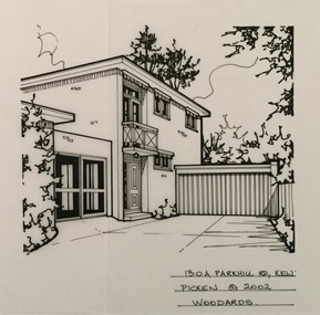 Kew Historical Society Inc
Drawing - Property Illustration, Margaret Picken, 130A Parkhill Road, Kew, 2002
After training as a Cartographic Draftsman within the mining industry, I worked as a property illustrator for real estate firms in the eastern suburbs of Melbourne for 22 years from 1983. I initially photographed houses with a Polaroid camera and made a 'thumbnail' sketch while there. The photos were used to scale off a sketch in pencil and then that sketch was overlaid with drafting film and the 'pen and ink' completed. The pens I used were the Rotring ‘Rapidigraph’ drafting pens. The ink was also made by Rotring (German).The film was ‘Rapidraw’, polyester drafting film, double matte. It takes a very fine line and doesn’t bleed. As well as house sketches, there were often floor plans and site plans ordered. Aerial sketches were ordered when the property needed an overall view. (Margaret Picken, 2020)This drawing is one of a series created by Margaret Picken for a number of real estate agents in Melbourne between 1983 and 2005. Each work is signed and dated by the artist.Gift of Margaret Picken, 2020Pen and ink architectural drawing on drafting film of 130A Park Hill Road, Kew by Margaret Picken.130A PARK HILL ROAD., KEW / PICKEN ©2002 / WOODARDSartist -- margaret picken 1950-, architectural drawings -- houses -- kew (vic.), 130a parkhill road -- kew (vic.) -
Ringwood and District Historical Society
Booklet, Greenwood Park Kindergarten Parents Club, Greenwood Park Kindergarten: Parents Club 40th Anniversary Booklet 1945-1985, 1985
Booklet prepared for the Greenwood Park Kindergarten Parents Club (Formerly Ringwood Pre-School Parent's Club 40th anniversary 1945 - 1985.Booklet with pink covers, red spine, 7 pages of white, typed pages inserted.Greenwood Park Kindergarten -
Glenelg Shire Council Cultural Collection
Photograph, Entrance Gates to Island Park Casterton, c. 1963
SOURCED FROM CASTERTON TOWN HALL (FORMER SHIRE OF GLENELG)Black and white photo showing entrance gates to Island Park CastertonBack: 'Entrance gates and track leading to oval at Island Park Casterton' - handwritten, green biro -
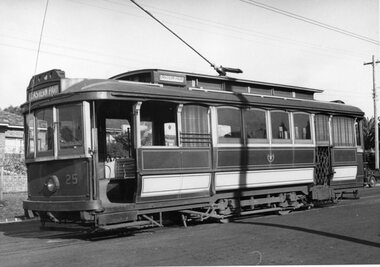 Ballarat Tramway Museum
Photograph - Black & White Photograph/s, John Webster, early 1950's
Yields information about the appearance of one of Geelong trams early 1950's with a little information about the background.Black and white photograph of Geelong No. 25 at Eastern Park. Photograph shows excellent detail the general arrangements of the body, signs, seats . Little background information. Tram has the destination of Eastern Park and a "Pay as you enter" sign by the open door.On rear in ink "SEC Geelong #25 @ Eastern Park" and "W. John Webster".tramways, trams, geelong, eastern park, tram 25 -
 Kew Historical Society Inc
Photograph - Flooding of the Yarra Valley at Kew East, 1974
Flooding of the Yarra Valley, including that section of the Yarra bordering Kew and Kew East in the north and west of the municipality, was a regular occurrence. Extreme flood events of the Yarra River are recorded to have occurred in 1891, 1901, 1916, 1923 and 1934. The Municipality of Kew's response to these floods was to enact planning decisions restricting residential development in flood prone areas following the floods of 1916, 1921 and 1934. While floods continued after the development of the Upper Yarra Reservoir (construction 1948-57), the regularity and extent of these inundations diminished. During the nineteenth century, the land abutting the south side of the Yarra in Kew was devoted to dairy farming. In the twentieth century, before and after the construction of the Eastern Freeway, much of this low-lying area was used as golf courses and public parks.Late example of the capacity of the Yarra Valley at Kew to flood, even though drainage works and the Upper Yarra Reservoir had reduced their regularity.Original black and white print photograph of the low-lying land at East Kew under floodwater on 16 May 1974. The photograph is of Hyde Park looking north-east.Annotation verso: "Hyde Park looking nth-east / Flood Level / 16 May 1974 11.15am / R.L. 46.61"floods, yarra river, hyde park -
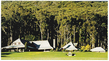 Marysville & District Historical Society
Photograph (Item) - Colour photograph, Unknown
A colour photograph of Howen Park.A colour photograph of Howen Park.howen park, photograph -
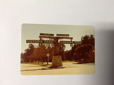 Port of Echuca
Colour Photograph, Approx.1979
In 1869 the Council moved to name this park "Victoria Park. The cricket pitch construction began in 1873 and major improvements to the ground were undertaken in 1881. It is still the primary sporting ground in Echuca, offering AFL football oval, cricket pitch and nets, athletics and entry to the Echuca boat ramp and the natural bush land of the scenic drive. It also houses Echuca Council caravan park. The signage in this photograph is no longer there and the enterance to the caravan park has moved.This area of Echuca has historically been a major recreational area for the town. Being the primary sporting ground since its establishment in 1869., the area has a number of sporting and recreational facilities for the people of Campaspe Shire, from natural bush walks in and along the Murray river to more formal facilities such as AFL football ground, firefighting training area, netball courts, cricket pitch and nets, and grass tennis courts. Colour photograph (post-card size) of directory signs to entrance of Victoria Park, Echuca taken facing north. Two driveways are shown, to the east "Caravan Park" and to the west , "Victoria Park", "Boat ramp", " Scenic drive"Printed in black on the reverse:"this paper manufactured by Kodak"echuca, port of, echuca council caravan park, victoria park, echuca, echuca-tourist attraction -
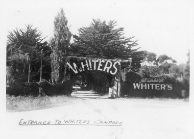 Lakes Entrance Historical Society
Postcard - whiters camp park, Bulmer H D, 1945c
One of a set of eight small format postcardsBlack and white small format postcard taken from road, showing entrance, treed with signage above double gated driveway at Whiters Camp Park. Sign on fence at eastern side of gateway, Still Australia's Best. Lakes Entrance VictoriaEntrance to Whiters Camp Parkresort, tourism, recreation -
 Lakes Entrance Historical Society
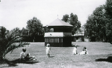
Photograph, Bulmer H D, Whiters Camp Park, 1940c
Black and white photograph showing original band rotunda, Whiters Camp Park, surrounded by manicured lawns, five people in foregound. Lakes Entrance VictoriaThe Band Rotunda, Whiters Camping Park, Lakes Entranceresort, recreation -
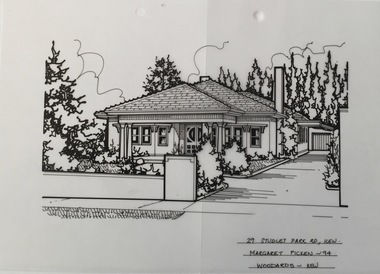 Kew Historical Society Inc
Drawing - Property Illustration, Margaret Picken, 29 Studley Park Road, Kew, 1994
After training as a Cartographic Draftsman within the mining industry, I worked as a property illustrator for real estate firms in the eastern suburbs of Melbourne for 22 years from 1983. I initially photographed houses with a Polaroid camera and made a 'thumbnail' sketch while there. The photos were used to scale off a sketch in pencil and then that sketch was overlaid with drafting film and the 'pen and ink' completed. The pens I used were the Rotring ‘Rapidigraph’ drafting pens. The ink was also made by Rotring (German).The film was ‘Rapidraw’, polyester drafting film, double matte. It takes a very fine line and doesn’t bleed. As well as house sketches, there were often floor plans and site plans ordered. Aerial sketches were ordered when the property needed an overall view. (Margaret Picken, 2020)This drawing is one of a series created by Margaret Picken for a number of real estate agents in Melbourne between 1983 and 2005. Each work is signed and dated by the artist.Gift of Margaret Picken, 2020Pen and ink architectural drawing on drafting film of 29 Studley Park Road, Kew by Margaret Picken.29 STUDLEY PARK RD., KEW / MARGARET PICKEN ~94 / WOODARDS ~ KEWartist -- margaret picken 1950-, architectural drawings -- houses -- kew (vic.), 29 studley park road - kew (vic) -
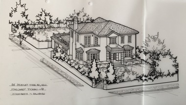 Kew Historical Society Inc
Drawing - Property Illustration, Margaret Picken, 55 Studley Park Road, Kew, 1998
After training as a Cartographic Draftsman within the mining industry, I worked as a property illustrator for real estate firms in the eastern suburbs of Melbourne for 22 years from 1983. I initially photographed houses with a Polaroid camera and made a 'thumbnail' sketch while there. The photos were used to scale off a sketch in pencil and then that sketch was overlaid with drafting film and the 'pen and ink' completed. The pens I used were the Rotring ‘Rapidigraph’ drafting pens. The ink was also made by Rotring (German).The film was ‘Rapidraw’, polyester drafting film, double matte. It takes a very fine line and doesn’t bleed. As well as house sketches, there were often floor plans and site plans ordered. Aerial sketches were ordered when the property needed an overall view. (Margaret Picken, 2020)This drawing is one of a series created by Margaret Picken for a number of real estate agents in Melbourne between 1983 and 2005. Each work is signed and dated by the artist.Gift of Margaret Picken, 2020Pen and ink architectural drawing on drafting film of 55 Studley Park Road, Kew by Margaret Picken.55 STUDLEY PARK RD., KEW / MARGARET PICKEN ~98 / WOODARDS ~ HAWTHORNartist -- margaret picken 1950-, architectural drawings -- houses -- kew (vic.), 55 studely park road - kew (vic)