Showing 162 items
matching pine hill
-
 Surrey Hills Historical Society Collection
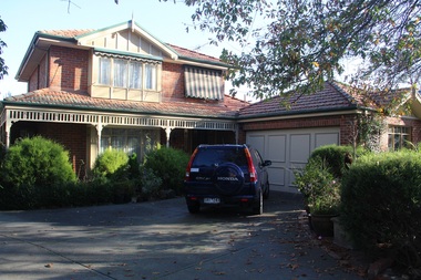
Photograph - 30 Pine Street, Surrey Hills, On The Street Where You Live Project
... Where You Live Project Photograph 30 Pine Street, Surrey Hills ...Photos documenting this address as part of a photographic series undertaken by volunteer photographers during 2013 and 2014 for The Street Where You Live Project. This was organised through the Surrey Hills Neighbourhood Centre and covered the postcode 3127 in the cities of Boroondara and Whitehorse.These photos provide a snapshot of real estate in the suburbs of Mont Albert and Surrey Hills during a period of rapid change with many properties on large blocks demolished to create higher density residential development or renewal of single dwellings. At particular risk were properties not covered by heritage overlays, especially interwar housing and post 1950's housing. -
 Surrey Hills Historical Society Collection
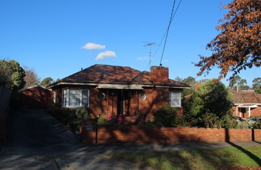
Photograph - 31 Pine Street, Surrey Hills, On The Street Where You Live Project
... Where You Live Project Photograph 31 Pine Street, Surrey Hills ...Photos documenting this address as part of a photographic series undertaken by volunteer photographers during 2013 and 2014 for The Street Where You Live Project. This was organised through the Surrey Hills Neighbourhood Centre and covered the postcode 3127 in the cities of Boroondara and Whitehorse.These photos provide a snapshot of real estate in the suburbs of Mont Albert and Surrey Hills during a period of rapid change with many properties on large blocks demolished to create higher density residential development or renewal of single dwellings. At particular risk were properties not covered by heritage overlays, especially interwar housing and post 1950's housing. -
 Surrey Hills Historical Society Collection
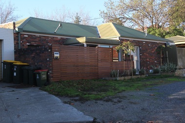
Photograph - 31A Pine Street, Surrey Hills, On The Street Where You Live Project
... Where You Live Project Photograph 31A Pine Street, Surrey Hills ...Photos documenting this address as part of a photographic series undertaken by volunteer photographers during 2013 and 2014 for The Street Where You Live Project. This was organised through the Surrey Hills Neighbourhood Centre and covered the postcode 3127 in the cities of Boroondara and Whitehorse.These photos provide a snapshot of real estate in the suburbs of Mont Albert and Surrey Hills during a period of rapid change with many properties on large blocks demolished to create higher density residential development or renewal of single dwellings. At particular risk were properties not covered by heritage overlays, especially interwar housing and post 1950's housing. -
 Surrey Hills Historical Society Collection
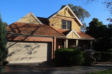
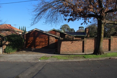
Photograph - 32 Pine Street, Surrey Hills, On The Street Where You Live Project
... Where You Live Project Photograph 32 Pine Street, Surrey Hills ...Photos documenting this address as part of a photographic series undertaken by volunteer photographers during 2013 and 2014 for The Street Where You Live Project. This was organised through the Surrey Hills Neighbourhood Centre and covered the postcode 3127 in the cities of Boroondara and Whitehorse.These photos provide a snapshot of real estate in the suburbs of Mont Albert and Surrey Hills during a period of rapid change with many properties on large blocks demolished to create higher density residential development or renewal of single dwellings. At particular risk were properties not covered by heritage overlays, especially interwar housing and post 1950's housing. -
 Surrey Hills Historical Society Collection
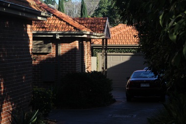
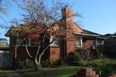
Photograph - 33 Pine Street, Surrey Hills, On The Street Where You Live Project
... Where You Live Project Photograph 33 Pine Street, Surrey Hills ...Photos documenting this address as part of a photographic series undertaken by volunteer photographers during 2013 and 2014 for The Street Where You Live Project. This was organised through the Surrey Hills Neighbourhood Centre and covered the postcode 3127 in the cities of Boroondara and Whitehorse.These photos provide a snapshot of real estate in the suburbs of Mont Albert and Surrey Hills during a period of rapid change with many properties on large blocks demolished to create higher density residential development or renewal of single dwellings. At particular risk were properties not covered by heritage overlays, especially interwar housing and post 1950's housing. -
 Surrey Hills Historical Society Collection
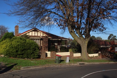
Photograph - 34 Pine Street, Surrey Hills, On The Street Where You Live Project
... Where You Live Project Photograph 34 Pine Street, Surrey Hills ...Photos documenting this address as part of a photographic series undertaken by volunteer photographers during 2013 and 2014 for The Street Where You Live Project. This was organised through the Surrey Hills Neighbourhood Centre and covered the postcode 3127 in the cities of Boroondara and Whitehorse.These photos provide a snapshot of real estate in the suburbs of Mont Albert and Surrey Hills during a period of rapid change with many properties on large blocks demolished to create higher density residential development or renewal of single dwellings. At particular risk were properties not covered by heritage overlays, especially interwar housing and post 1950's housing. -
 Surrey Hills Historical Society Collection
Photograph - 35 Pine Street, Surrey Hills, On The Street Where You Live Project
... Where You Live Project Photograph 35 Pine Street, Surrey Hills ...Photos documenting this address as part of a photographic series undertaken by volunteer photographers during 2013 and 2014 for The Street Where You Live Project. This was organised through the Surrey Hills Neighbourhood Centre and covered the postcode 3127 in the cities of Boroondara and Whitehorse.These photos provide a snapshot of real estate in the suburbs of Mont Albert and Surrey Hills during a period of rapid change with many properties on large blocks demolished to create higher density residential development or renewal of single dwellings. At particular risk were properties not covered by heritage overlays, especially interwar housing and post 1950's housing. -
 Surrey Hills Historical Society Collection
Photograph - 37 Pine Street, Surrey Hills, On The Street Where You Live Project
... Where You Live Project Photograph 37 Pine Street, Surrey Hills ...Photos documenting this address as part of a photographic series undertaken by volunteer photographers during 2013 and 2014 for The Street Where You Live Project. This was organised through the Surrey Hills Neighbourhood Centre and covered the postcode 3127 in the cities of Boroondara and Whitehorse.These photos provide a snapshot of real estate in the suburbs of Mont Albert and Surrey Hills during a period of rapid change with many properties on large blocks demolished to create higher density residential development or renewal of single dwellings. At particular risk were properties not covered by heritage overlays, especially interwar housing and post 1950's housing. -
 Surrey Hills Historical Society Collection
Photograph - 39 Pine Street, Surrey Hills, On The Street Where You Live Project
... Where You Live Project Photograph 39 Pine Street, Surrey Hills ...Photos documenting this address as part of a photographic series undertaken by volunteer photographers during 2013 and 2014 for The Street Where You Live Project. This was organised through the Surrey Hills Neighbourhood Centre and covered the postcode 3127 in the cities of Boroondara and Whitehorse.These photos provide a snapshot of real estate in the suburbs of Mont Albert and Surrey Hills during a period of rapid change with many properties on large blocks demolished to create higher density residential development or renewal of single dwellings. At particular risk were properties not covered by heritage overlays, especially interwar housing and post 1950's housing. -
 Surrey Hills Historical Society Collection
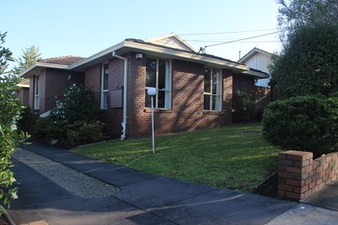
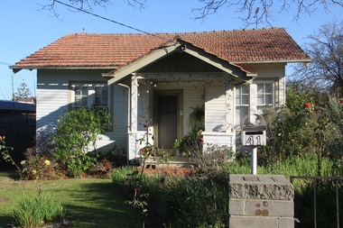
Photograph - 41 Pine Street, Surrey Hills, On The Street Where You Live Project
... Where You Live Project Photograph 41 Pine Street, Surrey Hills ...Photos documenting this address as part of a photographic series undertaken by volunteer photographers during 2013 and 2014 for The Street Where You Live Project. This was organised through the Surrey Hills Neighbourhood Centre and covered the postcode 3127 in the cities of Boroondara and Whitehorse.These photos provide a snapshot of real estate in the suburbs of Mont Albert and Surrey Hills during a period of rapid change with many properties on large blocks demolished to create higher density residential development or renewal of single dwellings. At particular risk were properties not covered by heritage overlays, especially interwar housing and post 1950's housing. -
 Surrey Hills Historical Society Collection
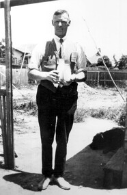
Photograph, Alfred Charles Bignell, dairyman of Balwyn and surrounding areas
... in Box Hill Cemetery. dairyman lone pine dairy alfred charles ...The man is Alfred Charles Bignell (1890-1965), dairyman of 6 Parring Road, Balwyn. Alf served in WW1 (SERN 781); enlisted at Apollo Bay; member of 4th Light Horse Regiment, 3rd Reinforcement; spent time on Gallipoli and in France and England. Alf is remembered, as Alfred Bignell, in the Ballarat Avenue of Honour as he spent time in the area with the Williams family. He married in England and after the war briefly returned to Apollo Bay before initially settling in Surrey Hills, where he worked for dairyman Canterbury Oliver Towt. He went on to buy the dairy at 6 Parring Road, Balwyn from Charles W Woolfe. He named it Lone Pine Dairy and the family continued to operate it after his death until c2005 when it was sold. Buried in Box Hill Cemetery.Black & white photo of a man standing under a veranda or similar. He is holding a cream and a milk bottle. There is a dog at his feet and rough ground in the background.dairyman, lone pine dairy, alfred charles bignell, parring road, balwyn, alfred charles williams, charles w woolfe -
 Surrey Hills Historical Society Collection
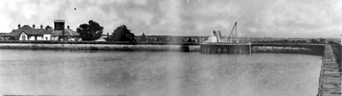
Photograph, Surrey Hills Reservoir No 1
Copied by Ken Hall from an early postcard. This is Surrey Hills Reservoir No 1 on the corner of Tower Street built in c1892 at a cost of £12,000 to supply higher sections of the area. The builders were Jack and Bob Laudehr, partners in a wood yard in St. Kilda (Vic). They began by delivering firewood but extended to contract work involving timber. Another of their projects was to lay cable tram tracks commencing in Acland Street St. Kilda and running along The Esplanade. The reservoir in Canterbury Road was a large concrete structure built before the introduction of reinforcements. The excavated material was banked against the sides and pine trees were planted in it to add strength to the embankment. They were paid £2,000 for their work. Construction of Surrey Hills Number 2 Reservoir was completed in 1913 and the accompanying tower was built in 1929. It is assumed that the Miss Hill as the source of the donation (via Bill Dempsey) was Ivy Annie Hill (1902-1984). She was the only female child of William Valentine Dempsey to not marry. Bill Dempsey's mother was Laura Constance 'Birdie' Hill (1900-1968) who married Albert Dempsey.A sepia photograph within a post card of a reservoir on Canterbury Road, Surrey Hills. In the background to the left you can see the top halves of two houses and the tops of some trees. The photo takes up only the central section of the postcard.Below the photo on the front of the postcard on blue biro "Reservor [sic] Canterbury Rd / Surrey Hills." On the rear in grey lead pencil in Jocelyn Hall's handwriting: "Donor W Dempsey ------------- Keep / (nephew) / [arrow pointing down] / From Miss Hill / 10 Pembroke St SH / This house can be / seen in front of / No 12 which has / tower"1890, water supply, mmbw, edward d dyer (mr), 10 pembroke street, 12 pembroke street, surrey hills, ivy annie hill (miss), william valentine hill (mr), canterbury road, tower street, water supply structures and establishments, dams and reservoirs, jack laudehr (mr), bob laudehr (mr) -
 Surrey Hills Historical Society Collection
Photograph, Entrance to Wattle Park from Riversdale Road, 1912-1914
Information provided by Stan Smith: Riversdale Road looking east 1912-1914. Wattle Park, then a farm is on the right. The near row of trees across the picture, indicates the driveway in Wattle Park. Wattle Park was then Fenwick's farm - or - Fennies to the local boys. Note: Riversdale Road becomes not much more than a track after passing the farm entrance.A dirt road in the lower left corner of the photograph is bounded by a post and rail fence. Two cyclists are on the road. "Wattle Park" is written to the right side of the road.wattle park, 1912, farms, 1914, fenwicks farm, fennies, fences, trees, roads and streets, riversdale road, pine trees, gum trees, cyclists -
 Surrey Hills Historical Society Collection
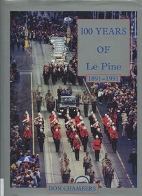
Book, One hundred years of Le Pine 1891 - 1991, 1994
This is the story of the development of Le Pine Services as it exists in the year 1991, beginning with its historical roots in the original small family undertaker's business of Joseph Le Pine of Bridge Road, Richmond. Graham Coward, Regional Manager of Le Pine, spoke at a Surrey Hills Historical Society meeting in 2000 and donated the book.202p; 4p of plates; ill; includes loose leaf pages of notes relating to Surrey HillsKINDLY PRESENTED / BY GRAHAM COWARD / LE PINES / JUNE 2000le pine funeral services, undertakers, funeral directors -
 Port Fairy Historical Society Museum and Archives
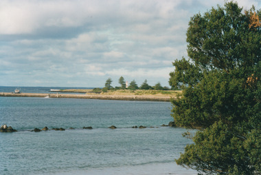
Photograph
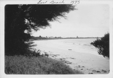
East Beach 1973Black and white photograph of East Beach with she oaks on the left and Norfolk Island pine in distanceNovember 1973 kodakeast beach, battery hill, ocean, sea, sand -
 Port Fairy Historical Society Museum and Archives
Photograph
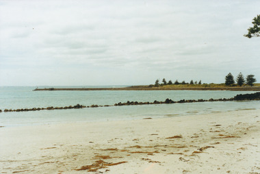
East BeachColoured photograph of Griffith Island with Norfolk Island Pines and remains of trolly walleast beach, battery hill, reef, training walls, norfolk pines -
 Surrey Hills Historical Society Collection
Photograph, Nick Pote, Medlow in 1990, 1990
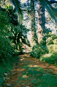
Built in 1889. Was known as 'Willcyrus' during the occupancy of Lieutenant Colonel (Lt Col) William McGregor Cairncross and family. It was named after two of his sons - Sergeant William McGregor Cairncross and Trooper Cyrus Hay Cairncross, who served with the 2nd Scottish Horse during the Boer War and in British units in the First World War. Lt Col Cairncross served at the Victoria Barracks in Melbourne for 25 years. During the Boer War he was controller of stores at Victoria Barracks. It was renamed 'Medlow' when it became the home of Dr Richard Joseph Bull (1874-1927) and his wife Catherine Grace, nee Perrier (1884-1972) in 1911. Richard Joseph Bull was the Director of Bacteriology at Melbourne University. Norma was a noted artist and was born in Hawthorn in 1906; her brother Ronald Richard was born in Surrey Hills in 1912. Fundraising events were held there during the First World War. The property was left to the National Trust of Victoria but the costs of maintenance forced the Trust to sell it and it has returned to private ownership.A coloured photograph taken up the driveway of 'Medlow'. It is covered with what appears to be pine needles and some weeds up the centre. There are large trees overhanging the drive and the garden appears to be somewhat overgrown. medlow, house names, warrigal road, surrey hills, (mrs) catherine bull, (miss) norma bull, house styles, late victorian boom style, (miss) catherine perrier, (mr) (dr) richard joseph bull, (mr) ronald joseph bull, (lt) (col) (mr) william mcgregor cairncross, (mr) william mcgregor cairncross, (mr) cyrus hay cairncross, willcyrus, garden parties, fundraising, world war, 1914-1918 -
 Surrey Hills Historical Society Collection
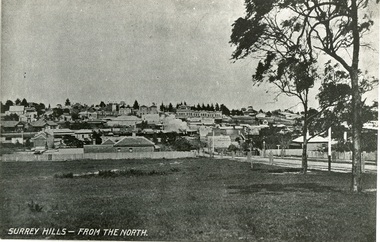
Photograph, Surrey Hills from north of Montrose Street 1907-1911
In the foreground is Dr Blakie's first surgery, later the Police Station, then a Service station. Behind and to the left are the two railway station buildings. On the horizon and in front of the pine trees is 'Montalto', home of the Hansen family, later Dr Box (demolished). Two storey terrace of shops in front of this is Hansen's Terrace. In centre, note smoke from steam train. On corner of Guildford Rd is a Gas Lamp. The first trees have been planted in Union Road and are protected with stout wood surround.Black and white photograph of a view of Surrey Hills. Written on the bottom left hand side "SURREY HILLS - FROM THE NORTH". In the foreground are two trees on the right hand side before a view leading up the hill. dr blakie, police station, hansen terrace, dr box, montalto, guildford rd, gas lamp, union road -
 Port Fairy Historical Society Museum and Archives
Photograph
East beach South endeast beach, battery hill, reef, training wall, island, norfolk pines -
 Canterbury History Group
Ephemera - touchstones to WW1 in Balwyn, Camberwell, Canterbury and Surrey Hills, Susan Barnett, 1/04/2015 12:00:00 AM
Booklet compiled by Susan Barnett, President of the Surrey Hills Historical Society with the assistance of the Balwyn Historical Society, Camberwell Historical Society, Canterbury History Group and the Surrey Hills Historical Society, for a bus tour of significant places in Boroondara to commerate the centenary of the Gallipoli Landing.beckett park memorial, white> dorothy sevilla, cahill> francis matthew, cahill> martin, cahill> richard nicholas, cahill> kevin martin, lone pine dairy - balwyn, bignell> alfred charles, canterbury citizens carnival, canterbury gardens, soldiers - memorial hall - canterbury, canterbury memorial home units, canterbury primary school, camberwell city rsl sub-branch, golding> herbert, daly> gustav anthony disney, daly> william constant beck, daly> clarence wells didier, wattle park lone pine, clock tower memorial> wattle park, hethersett house - plc - burwood, surrey gardens - memorial cross, surrey gardens - the shrine, steele> mrs charles h d, blogg> john kendrick, gawler> john stephens, mawson> frederick w, webster> clarence -
 Mentone Grammar School
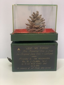
Archive, Memorial Cone from the original Lone Pine, Gallipoli, 1916
Memorial cone from the original 'Lone Pine' at Gallipoli, presented to Headmaster Neville Clarke by B Company, Mentone Grammar Cadet Unit, 15th August 1995 in memory of those who served. The Battle of Lone Pine was fought between Australian and New Zealand Army Corps (ANZAC) and Ottoman Empire forces during the Gallipoli Campaign of the First World War, between 6 and 10 August 1915. The battle was part of a diversionary attack to draw Ottoman attention away from the main assaults being conducted by British, Indian and New Zealand troops around Sari Bair, Chunuk Bair and Hill 971, which became known as the August Offensive. -
 Sunbury Family History and Heritage Society Inc.
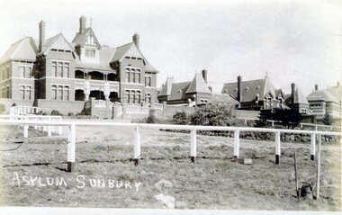
Photograph, Asylum Sunbury
The administrative building along with four other buildings were part of the former Sunbury Asylum complex that operated in Sunbury on Jacksons Hill from 1876 to 1992. The white fence in the front of the photo was the boundary for The Pines golf club where patients, staff and Sunbury residents played before the Goonawarra Golf Club was established.The Sunbury Asylum was an important institution in the town and many of the townspeople worked there over the 120 years of its operation.A non-digital sepia photograph in post card format with a white border across the bottom, of the administrative building and other brick Victorian style buildings that were part of the Sunbury Asylum complex. A white post and rail fence is in the foreground. sunbury asylum, caloola, the pines golf club -
 Warrnambool and District Historical Society Inc.
Booklet - Warrnambool Visitor's Handbooks 1979-2024, Collett, Bain and Gaspar, Printers, 1979-2014
This is a collection of eight Warrnambool Visitor handbooks produced between 1979 and 2014 by the City of Warrnambool Tourist Information Centre. They contain maps of Warrnambool, lists of services, accommodation and tourist attractions as well as many advertisements for local businesses.These handbooks give a useful snapshot of businesses and tourist attractions in Warrnambool for each of the years covered. (1979, 1980, 1986, 1990, 1993, 1994, 1995, 2014)[.1a] A 48 page booklet with white pages and blue printing. The front cover has a coloured photograph of Flagstaff Hill with boats on a man made lake in the foreground looking across Lake Pertobe toward South Warrnambool. [.1b] A coloured bifold brochure. The front cover has a fisherman on a cray-boat holding a crayfish in the lower section. The top quarter has a blue back ground with white printing. The rear cover is red and has small photos of the Hopkins River and the Framlingham Forest. [.2] A 48 page booklet with white pages and black printing. The front cover is white with black writing on the left hand side and a colour photograph of the Loch Ard peacock. The Warrnambool Premier Town stylised logo of seven Norfollk pines above blue waves is in the top right hand corner. There is a blank ink Warrnambool Library stamp underneath the logo. The rear cover has photographs of The Twelve Apostles and the Hopkins Falls and the Premier Town Logo [.3] A 40 page booklet with mainly black printing on white paper. There are three fold out maps of Warrnambool and the surrounding district. The glossy cover has a black background with a colour photograph of the Twelve Apostles taken at sunset. The rear cover has three small of Proudfoot's boathouse on the Hopkins River, Flagstaff Hill, and the main beach area. The front cover has black writing inside to peach coloured rectangles. The inside rear cover has a fold out coloured tour map of Western Victoria. [.4] A 40 page booklet printed on glossy white paper with coloured photographs and black and red printing. The front cover has a photograph of The Twelve Apostles surrounded by a white border. There is red writing in the upper border. There is a sandy coloured writing superimposed across the bottom of the photograph and a Victoria's Shipwreck Coast logo in the bottom right hand corner. [.5] A 44 page booklet printed on white paper with black printing. The cream coloured cover has a pale red rectangle with blue writing on the right hand facing edge and includes two stylised Norfolk pines and with waves underneath. There is is an intersecting blue rectangle with cream printing. [.6] A 48 page booklet printed on white paper with black printing. The cover is brown with a cream vertical strip containing black writing on the right hand side. There is a stylised map from Geelong to Mount Gambier showing the Great Ocean Road across the cover. [.7] A 48 page booklet printed on white paper with black print. The glossy colour cover has a photograph of a Southern Right whale fluke. There is white printing on a the blue background of the sky and sea. The bottom left hand side of the front cover has a Tourism Victoria logo made of jigsaw puzzle pieces. The back cover has a stylised coloured map of The Great Ocean Road located in a white rectangle at the top of the page. Within the rectangle is a small map of Australia locating Victoria and the part of Victoria covered by the map. [.8] A 64 page A5 coloured booklet printed on white pages with black print. The white front cover has black and grey print with a colour photograph of two people holding coffee cups watching four race horses being exercised on the beach and in the water of Lady Bay in the early morning. The bottom right hand corner has a Tourism Victoria logo. The rear cover has a mainly blue back ground with a pink orange and green colour splats contains words advertising the 2015 Fun 4 Kids Festival [.1a] Warrnambool The Heart of Victoria's Great Southwest Visitor's Handbook [.1b] Warrnambool City for all seasons; The Heart of Victoria's Great Southwest [.2] Warrnambool visitor's handbook Warrnambool Premier Town 1979-1982 [.3] Warrnambool Handbook Victoria [.4] Warrnambool The Shipwreck Coast [.5] Welcome to Warrnambool Warrnambool Visitors Handbook 1993-1994 [.6] Welcome to Warrnambool Visitors Handbook 1994-95 Rear cover: Warrnambool Centre of Victoria's Shipwreck Coast on Australia's Great Ocean Road [.7] Warrnambool Shipwreck Coast - Great Ocean Road; You'll love every piece of Victoria; Visitors Handbook [.8] Warrnambool Great Ocean Road Official Visitor Guide; It's a wonderful Warrnambool; You'll love every piece of Victoria visitvictoria.com. Rear Cover Live entertainment.Workshops.Creativity.Action 28 June - 5 July 2015 Australia's Best Children's Festival F4K The ultimate winter school holiday adventure Fun 4 kids festival Warrnambool For more information visit Fun4kids.com.au Warrnambool great Ocean Road Victoriawarrnambool, visitor handbooks, tourist information guides, warrnambool maps -
 Federation University Historical Collection
Book, Final recommendations Ballarat Study Area Land Conservation Council, Victoria, 1982, 1982
Yellow soft covered report of 95 pages . The contents of the report include: Parks, reference areas, wildlife reserves, water production, harwood production, softwood production, flora Reserves and Flora and Fauna reserves, bushland reserves, historic area and reserves, rivers and streams, Roadside conservation and Highway parks, Education areas and School Plantations, Lake Reserves, geological reserves, recreation, scenic reserves, agriculture, mineral and stone production, utilities and survey, township land, Uncommitted Land, military training, other reserves and public land. Maps include: The Study area 1: 250 000 Supplementary Mapsland conservation authority, ballarat, endowment plantations, pine plantations, langi ghiran state park, mount buangor state park, enfield state park, ballarat-creswick regional park, rossbridge, black lake, flax mill swamp, dereel lagoon, lake bolac, lake wongan, langi ghiran reservoir, gong gong reservoir, pincotts reservoir, beales reservoir, wilsons reservoir, moorabool reservoir, korweinguboora, korweinguborra reservoir, learmonth bores, sago hill, illabarook reservoir, ballarat water commission, dunneworthy, mount cole, mont lonarch, ben major, waterloo, trawalla, linton, ross creek, canadian, shepherds flat, lal lal, mount doran, raglan, chute, carngham, buninyong, watsons hill, enfield, cape clear, illabrook, rokewood junction, mount warrenheip, nerrina, jubilee, golden stream, australasian deep lead mine, happy valley school, piggoreet, berringa, bulldog, ballarat common, wildlife, water, timber, flora, rivers, geology, agriculture, warrenheip, biodiversity -
 Eltham District Historical Society Inc
Photograph - Digital Photograph, Alan King, Cameron family graves, Kangaroo Ground Cemetery, Eltham-Yarra Glen Road, Kangaroo Ground, 28 January 2008
Six year old Judith Furphy was the first person known to have been buried at Kangaroo Ground Cemetery in May 1851. The cemetery is situated on an ancient river bed with exposed Nillumbik sands. The rest of the district is formed from black volcanic soil which was hard to dig. According to local historian Mick Woiwod (deceased) the site may have been a burial ground for the local Wurundjeri people as the exposed softer sands were always their prefered camping sites. The Hon. Ewen Hugh Cameron who lived at Pigeon Bank and was the Member for Evelyn for 40 years (1874-1914) was buried here in 1915. Published: Nillumbik Now and Then / Marguerite Marshall 2008; photographs Alan King with Marguerite Marshall.; p39 The Wurundjeri people might have buried their dead on the site of the Kangaroo Ground Cemetery, according to local historian Mick Woiwod. Kangaroo Ground was a premier hunting ground, but camping on the black volcanic soil would have been uncomfortable. Unlike most of Kangaroo Ground, its cemetery, on an ancient river bed, comprises a rare exposure of Nillumbik sands – always the preferred campsite for Aboriginal people. The cemetery area is the only place where the soil was soft enough to dig a grave easily.1 Six-year-old Judith Furphy was the first person known to have been laid to rest at the Kangaroo Ground Cemetery. She died on May 17, 1851, from a chill caught by resting on wet grass. Local Andrew Ross wrote ‘..no public burying place existed nearer than Melbourne. The case being considered urgent, a general meeting of the settlers took place on the evening of the 17th……. The result was the selection of unoccupied crown land …….which was subsequently granted by Government for a public cemetery.’2 Judith was buried the next day on May 18. Her grave was marked by the trustees with a plaque, which unfortunately states nine years old, when she was probably only six. Judith came from an illustrious family. Her brother, Joseph, was the author of Such is Life and other works. Another brother, John, developed and manufactured the famous Furphy water cart, which distributed water to World War One soldiers along with the latest rumours. Hence the name Furphy entered the Australian idiom, as synonymous with ‘rumour’. Judith’s father Samuel helped build the first Kangaroo Ground church school. Inside, near the entrance of the cemetery, on Yarra Glen Road, stand a rotunda and a water tank. Occasional benches invite mourners to pause and remember. The gate with wrought iron and brick supports, bears the inscription ‘Erected by Sir Ewen and Lady Cameron in memory of their daughter, Flora Margaret’. These are only two of the famous people connected with this cemetery. The Hon. Ewen Hugh Cameron JP and MLA from 1874 to1914, who lived at Pigeon Bank, Warrandyte Road, was buried here in 1915. Unrelated, but with the same name, was Sir Ewen Cameron who had been Minister for Health and was laid to rest there in 1964. Sir Herbert Gepp, a leading industrialist and the former owner of Garden Hill, at Yarra Glen Road, was buried there in 1954.3 Many of the more imposing tombstones belong to the earlier graves. Unfortunately bushfires have cracked several. But this adds to the melancholy attractiveness of the cemetery, graced by some beautiful eucalypts, cypress and pines. Early pioneering families represented at the cemetery include Armstrong, Barr, Bell, Harkness, Jardine, Johnston, Rogerson, Stevenson, Thomson and Walters. Armstrong and Bell were among the first families to come to the district and Stevenson owned the district’s first sheep station. It took in much of present day Christmas Hills, which was the name he gave his sheep station. Harkness was the first to suggest a Kangaroo Ground school be built, and one of the first to suggest establishing the Eltham District Road Board. Many of these families leased pastoral land before the mid-century and bought land when it came on sale in 1849. In the cemetery’s early days sections were devoted to the major Christian denominations (mainly the Protestant) and one section was set aside for ‘other’ or ‘non-believers’. However in modern times burial plots have not been placed in areas according to religious beliefs.This collection of almost 130 photos about places and people within the Shire of Nillumbik, an urban and rural municipality in Melbourne's north, contributes to an understanding of the history of the Shire. Published in 2008 immediately prior to the Black Saturday bushfires of February 7, 2009, it documents sites that were impacted, and in some cases destroyed by the fires. It includes photographs taken especially for the publication, creating a unique time capsule representing the Shire in the early 21st century. It remains the most recent comprehenesive publication devoted to the Shire's history connecting local residents to the past. nillumbik now and then (marshall-king) collection, kangaroo ground, eltham-yarra glen road, agnes bell cameron, agnes cameron (nee bell), cameron family, edward aubrey haughton, eugene cameron, evelyn florence cameron, ewen hugh cameron, gravestones, jane armstrong, jane bell, jessie agnes haughton (nee cameron), jessie cameron, john donald cameron, kangaroo ground cemetery, neville cameron, simon armstrong, vera cameron, william bell armstrong, wurundjeri -
 Eltham District Historical Society Inc
Photograph - Digital Photograph, Alan King, St Matthew's Church and Hall, Panton Hill, 27 March 2008
St. Matthew's Church has historic significance as the town's church and physical and social focus for the community. The standard design buildings are good examples and important streetscape elements. The war memorial cross is the area's monument to the 20th century wars and its modest scale in comparison with the granite Eltham and towered Kangaroo Ground memorials illustrates the lack of affluence in the town and surrounding area. The grouping of church, school, store and post office is typical of country villages throughout Victoria. The Radiata Pine plantings are significant as an intact line of shelterbelt planting typical of the early 20th century. (Bick Study 1992) Covered under Heritage Overlay, Nillumbik Planning Scheme. Published: Nillumbik Now and Then / Marguerite Marshall 2008; photographs Alan King with Marguerite Marshall.; p63 Panton Hill’s first church services were held in a simple building made of paling timber, opposite the Hotel de France. The building was also used for Sunday School, a school and a hall.1 The St Matthew’s Church and hall at the corner of Church Road and Kangaroo Ground-St Andrews Road, were built in the early 20th century in the standard rectangular style of the times. The intact belt of Radiata Pines was common at that time. The war memorial concrete cross is the area’s monument for the 20th century wars. It is much more modest than those in Eltham, and particularly in Kangaroo Ground, demonstrating those townships’ comparative affluence.2 Early settler J Hughes, who donated the land to the Church of England, was the first to be married at St Matthews when he married Rachel Coutie. In later life he became a minister of religion.3 One much-liked preacher was George Hollow, who with his sister playing the harmonium, conducted church services at Panton Hill, St Andrews and Christmas Hills, for many years.This collection of almost 130 photos about places and people within the Shire of Nillumbik, an urban and rural municipality in Melbourne's north, contributes to an understanding of the history of the Shire. Published in 2008 immediately prior to the Black Saturday bushfires of February 7, 2009, it documents sites that were impacted, and in some cases destroyed by the fires. It includes photographs taken especially for the publication, creating a unique time capsule representing the Shire in the early 21st century. It remains the most recent comprehenesive publication devoted to the Shire's history connecting local residents to the past. nillumbik now and then (marshall-king) collection, panton hill, st matthew's church, panton hill war memorial -
 Glenelg Shire Council Cultural Collection
Painting - Oil Painting, Kenneth Jack, Captain Blair's House, n.d
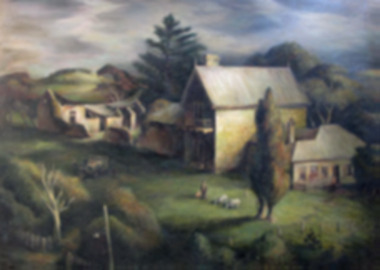
Image showing three stone buildings in a country scene. In the foreground there is man and child and two goats. There is a car with three people surrounding it. The weather looks dark, dark clouds. A large Norfolk Pine behind the building. The middle building is two storey with an outhouse attached. A chimney and two spires at each end of the house. The building to the right of the main building is weatherboard with a fence. To the left of the main building is a ruined stone building with the roof fallen in. Trees and hills surround. Gold painted frame.Bottom right - Kenneth Jack - July 1952 -
 Bendigo Historical Society Inc.
Photograph - HILDA HILL COLLECTION: BLACK AND WHITE PHOTOS, 1917-1922
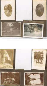
Series of Black & White Photos Total 8 Hill Family & Friends during the final years of World War I and into the touring boom of the 1920s. Lady dressed in all white, with dark coloured scarf over her shoulder, parasol in her right hand, in conversation with The Dean January 28th 1918.Oval photo of young girl dressed in dark skirt and white blouse in bush setting with trees in background, photo not very clear, 'Durvol' Kyneton 1918. Mollie & Babe Railway Reserve Kyneton, girl in light coloured dress reclining on the ground, other girl in kneeling position wears dark skirt and white blouse, palm tree to the left background, further back is paling fence, shrubbery to the right background, 1918. Horse & 4 wheeled Gig, man seated wears a dark suit with white shirt and dark tie, horse appears to be a grey colour, background shows bull nose veranda roof and part of a house gable, tree in framework on nature strip. Nell wearing a dark skirt and white top, right hand touching a shrub, white structure in the background, 'The Ranch' Eppalock November 1918. Botanical Gardens group photo, six young ladies, one wearing a vertical striped dress, three wear dark dresses with white blouses, two wear white blouses and dark skirts, one black hat and three light coloured, light hat in right foreground, January 1919. Jack & Mick in dark suits, white shirts, striped ties, shrubbery in the background, long trousers 'The Ranch' Eppalock January 14th 1917. two young ladies in all white, one holding a hat, young boy in dark clothing white shirt and dark tie, holding long stick, large shrub in the background, 'The Pines' Kyneton January 1919.Hilda Hill Personal Collectionaustralia, history, post war life -
 Bendigo Historical Society Inc.
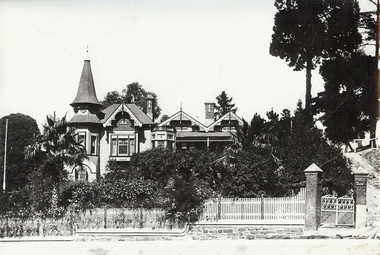
Photograph - THE EYRIE: QUARRY HILL, pre 1932
Black and white photo, 'The Eyrie' turretted and gabled roof line. Picket fence, brick pillars on gatewah with gravel path up on right to pine trees. Overgrown garden, with palm trees. On stick on label ' date unknown pre 1922 when steps were put in palms now well grown. Verandah canopy no longer striped wooden gates gone. House restored in 1998. To original colour scheme and verandahs now striped.buildings, residential, the eyrie -
 Lakes Entrance Historical Society
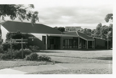
Photograph - Senior Citizen's Centre, 1989
Built on part of former Primary School pine plantation.Colour photograph of Lakes Entrance Seniors Club Rooms at Coates Road, showing a brick building with hip roof. Ramp to side entry, main entry on east side. Tambo Shire Offices on hill in background. Lakes Entrance Victoriacommunity facilities, recreation