Showing 25571 items matching "plenty-township-estate"
-
 Greensborough Historical Society
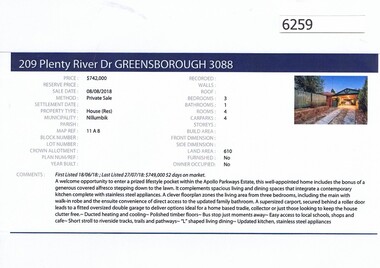
Advertising Leaflet, Barry Plant Greensborough, 209 Plenty River Drive Greensborough, 08/08/2018
Real estate advertisement for 209 Plenty River Drive Greensborough, a 3 bedroom house. This house was sold in July 2018 for $742,000. Previous sales: June 2012 for $490,000; December 1998 $134,000 and December 1985 for $83,000.Real estate advertisement black text and colour photographplenty river drive greensborough -
 Ringwood and District Historical Society
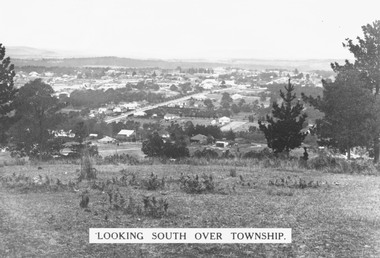
Photograph, Looking south over Ringwood township from Loughnans Hill c1930. Ringwood Street is the main road in the centre
Black and white photograph taken from hill overlooking township of Ringwood. (3 copies)Printed on photograph, "Looking south over township". Typed below photograph, "View from Loughnans Hill c1930. Ringwood Street is the main road in the centre. Old St. Pauls, railway crossing, Methodist church, state school, coolstores, etc. can all be seen". -
 Greensborough Historical Society
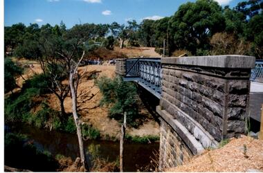
Photograph - Digital Image, Anne Paul, Opening of restored Old Lower Plenty Bridge 2001 - side view of bridge, 14/03/2001
The opening of the restored Old Lower Plenty Bridge, opened on 14/03/2001 by the Minister for Environment and Conservation Sherryl Garbutt MLA and Mayor of Banyule Cr Dale Peters. The project was jointly funded by Banyule Council and Parks Victoria. The restored bridge is the oldest remaining bridge in the former Shire of Eltham and forms part of the Plenty River Trail. This photograph shows the bridge from the side elevation, showing the bluestone and iron construction.Digital copy of colour photographlower plenty, lower plenty bridge, sherryl garbutt, dale peters, banyule council, parks victoria -
 Ringwood and District Historical Society
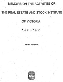
Book, Memoires of the Activities of the Real Estate and State Institute of Victoria 1936-1980 by G.A.Thomson
Written for the Real Estate and Stock Institute of Victoria106 pages of the life and times of Mr. George Thomson as a Real Estate Agent and the history taken from minutes and proceedings of the Real Estate and Stock Institute from its inception. Clear plastic covers with blue cloth spine. Typewritten with some reproduced pictures.Front cover has The Real Estate and Stock Institute logo in the bottom quarter. Back page has faded picture of the Lebanese Catholic Church in Rathdowne Street, Melbourne. -
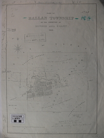 Ballan Shire Historical Society
Map - Map. Ballan Township, Plan of Ballan Township in the Counties of Bourke and Grant
The map is an early one of the township of Ballan showing street names and land owners.The map is significant in that it lists the owners of the house blocks within the township.A map showing the township and surrounding area of Ballan in 1856. Town streets are named as are the owners of the subdivided blocks of land. The map is a lithocopy and there is a scale in chains."D D Fraser" is written across the top of the map and "1856" is written in the near top right corner. There are other additions to the map but they are very difficult to decipher accurately or completely.ballan, ballan township map, ballan1856 -
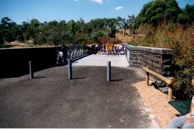 Greensborough Historical Society
Photograph - Digital Image, Anne Paul, Opening of restored Old Lower Plenty Bridge 2001 - bridge and community, 14/03/2001
The opening of the restored Old Lower Plenty Bridge, opened on 14/03/2001 by the Minister for Environment and Conservation Sherryl Garbutt MLA and Mayor of Banyule Cr Dale Peters. The project was jointly funded by Banyule Council and Parks Victoria. The restored bridge is the oldest remaining bridge in the former Shire of Eltham and forms part of the Plenty River Trail. This photograph shows the bridge area ready for the opening ceremony and the assembled community members attending the function.Digital copy of colour photographlower plenty, lower plenty bridge, sherryl garbutt, dale peters, banyule council, parks victoria -
 Eltham District Historical Society Inc
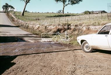
Slide, In front of Martin property drive on Bonds Road looking east up Montpelier Drive, Lower Plenty, 18 July 1972, 1972
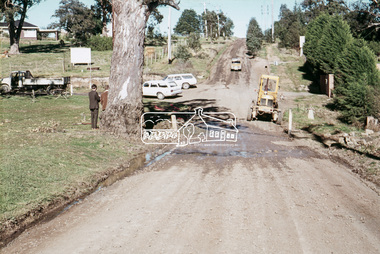
Water drainage work undertaken by Eltham Shire Council in Bonds Road, Lower Plenty outside the Martin property opposite Montpelier Drive, July 197235 mm colour positive transparency Mount - Agfacolor Service (Blue)Bonds Road (Martin property) 12.10 pm 18.7.72bonds road, drainage works, eltham shire council, infrastructure, lower plenty, martin property, montpelier drive -
 Eltham District Historical Society Inc
Slide, On the east side of Bonds Road looking west onto Martin's property, Lower Plenty, 18 July 1972, 1972
Water drainage work undertaken by Eltham Shire Council in Bonds Road, Lower Plenty outside the Martin property opposite Montpelier Drive, July 1972 35 mm colour positive transparency Mount - Agfacolor Service (Blue)Bonds Road (Martin property) 12.10 pm 18.7.72bonds road, drainage works, eltham shire council, infrastructure, lower plenty, martin property, montpelier drive -
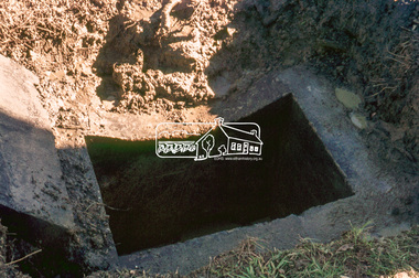 Eltham District Historical Society Inc
Slide, Pit located on the east side of Bonds Road, Lower Plenty, 18 July 1972, 1972
Water drainage work undertaken by Eltham Shire Council in Bonds Road, Lower Plenty outside the Martin property opposite Montpelier Drive, July 1972 35 mm colour positive transparency Mount - Agfacolor Service (Blue)Bonds Road (Martin property) 12.10 pm 18.7.72bonds road, drainage works, eltham shire council, infrastructure, lower plenty, martin property, montpelier drive -
 Eltham District Historical Society Inc
Slide, Looking westerly into Martin's property across Bonds Road, Lower Plenty, 18 July 1972, 1972
Water drainage work undertaken by Eltham Shire Council in Bonds Road, Lower Plenty outside the Martin property opposite Montpelier Drive, July 1972 35 mm colour positive transparency Mount - Agfacolor Service (Blue)Bonds Road (Martin property) 12.10 pm 18.7.72bonds road, drainage works, eltham shire council, infrastructure, lower plenty, martin property, montpelier drive -
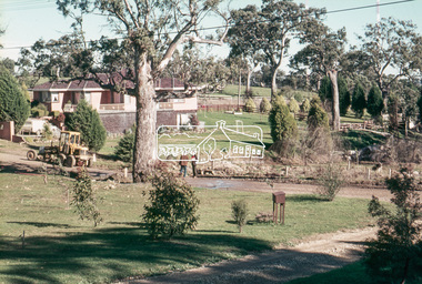 Eltham District Historical Society Inc
Slide, View of Martin's house indicating its relationship to the gully, Bonds Road, Lower Plenty, 18 July 1972, 1972
Water drainage work undertaken by Eltham Shire Council in Bonds Road, Lower Plenty outside the Martin property opposite Montpelier Drive, July 1972 35 mm colour positive transparency Mount - Agfacolor Service (Blue)Bonds Road (Martin property) 12.10 pm 18.7.72bonds road, drainage works, eltham shire council, infrastructure, lower plenty, martin property, montpelier drive -
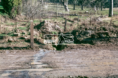
 Eltham District Historical Society Inc
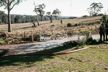
Slide, Looking south, post drainage repairs on Bonds Road near Martin property and Montpelier Drive, Lower Plenty, c.July 1972, 1972
Water drainage work undertaken by Eltham Shire Council in Bonds Road, Lower Plenty outside the Martin property opposite Montpelier Drive, July 1972 35 mm colour positive transparency Mount - Agfacolor Service (Blue)Bonds Road (Martin property) 12.10 pm 18.7.72bonds road, drainage works, eltham shire council, infrastructure, lower plenty, martin property, montpelier drive -
 Eltham District Historical Society Inc
Slide, Post drainage repairs on Bonds Road near Martin property and Montpelier Drive, Lower Plenty, c.July 1972, 1972
Water drainage work undertaken by Eltham Shire Council in Bonds Road, Lower Plenty outside the Martin property opposite Montpelier Drive, July 1972 35 mm colour positive transparency Mount - Agfacolor Service (Blue)Bonds Road (Martin property) 12.10 pm 18.7.72bonds road, drainage works, eltham shire council, infrastructure, lower plenty, martin property, montpelier drive -
 Eltham District Historical Society Inc
Slide, Looking north post drainage repairs on Bonds Road near Martin property and Montpelier Drive, Lower Plenty, c.July 1972, 1972
Water drainage work undertaken by Eltham Shire Council in Bonds Road, Lower Plenty outside the Martin property opposite Montpelier Drive, July 1972 35 mm colour positive transparency Mount - Agfacolor Service (Blue)Bonds Road (Martin property) 12.10 pm 18.7.72bonds road, drainage works, eltham shire council, infrastructure, lower plenty, martin property, montpelier drive -
 Eltham District Historical Society Inc
Slide, Post drainage repairs on Bonds Road near Martin property and Montpelier Drive, Lower Plenty, c.July 1972, 1972
Water drainage work undertaken by Eltham Shire Council in Bonds Road, Lower Plenty outside the Martin property opposite Montpelier Drive, July 1972 35 mm colour positive transparency Mount - Agfacolor Service (Blue)Bonds Road (Martin property) 12.10 pm 18.7.72bonds road, drainage works, eltham shire council, infrastructure, lower plenty, martin property, montpelier drive -
 Eltham District Historical Society Inc
Slide, Post drainage repairs on Bonds Road near Martin property and Montpelier Drive, Lower Plenty, c.July 1972, 1972
Water drainage work undertaken by Eltham Shire Council in Bonds Road, Lower Plenty outside the Martin property opposite Montpelier Drive, July 1972 35 mm colour positive transparency Mount - Agfacolor Service (Blue)Bonds Road (Martin property) 12.10 pm 18.7.72bonds road, drainage works, eltham shire council, infrastructure, lower plenty, martin property, montpelier drive -
 Ringwood and District Historical Society
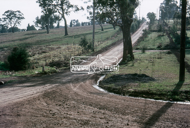
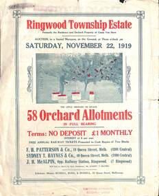
Pamphlet - Land Auction Brochure, Ringwood Township Estate, Ringwood, Victoria - 1919
Double sided bi-fold leaflet advertising subdivision site, layout of streets and allotments, summary of local features and services and terms of sale. Inset photographs of local views.Auction Saturday November 22, 1919. 58 Orchard Allotments. Formerly the residence and orchard property of Count Von Horn. Subdivision includes Wantirna Road, Ellison Street, Haig Street. Free annual railway tickets presented to cash buyers of two blocks. Agents - F.H. Patterson & Co., 19 Queen Street, Melbourne, Tel Central 4308, Sydney T. Haynes & Co., 60 Queen Street, Melbourne, Tel. Central 3400, J.B. McAlpin, Opp Railway Station, Ringwood, Tel. Ringwood 7. Auctioneer - Mr. Sydney T. Haynes. Solicitors - Messrs. Russell, Bona & Russell, 19 Queen Street, Melbourne. -
 Ringwood and District Historical Society
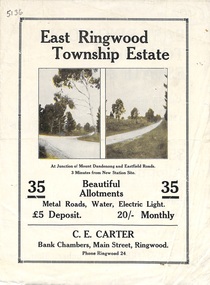
Flyer, Subdivisional Land Sale Brochure, East Ringwood Township Estate, Vic. - 1923
Bi-folded double sided land subdivision sale advertisement with location map and summary of local facilities and services. Includes two additional images of allotment plan with subsequent handwritten notations.Subdivision includes Mount Dandenong Road, Grey Street, and Eastfield Road. Agent - C.E. Carter, Bank Chambers, Main Street, Ringwood. Phone Ringwood 24. -
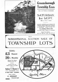 Greensborough Historical Society
Plan - Digital Image, Greensborough Township Estate, 01/09/1923
Sub-division into 129 lots of land belonging to the Scotland Family, bounded by William Street, Eliza Street, James (Jessop) Street and south of Lorimer Street. Auction 1 September 1923Digital copy of plan. Has been digitally corrected from damaged original.subdivision plans, greensborough township estate, scotland family -
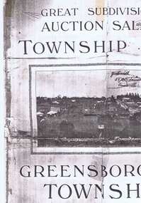 Greensborough Historical Society
Plan, Greensborough Township Estate, 01/09/1923
Sub-division into 129 lots of land belonging to the Scotland Family, bounded by William Street, Eliza Street, James (Jessop) Street and south of Lorimer Street. Auction 1 September 1923Photocopy, double-sidedsubdivision plans, greensborough township estate, scotland family -
 Greensborough Historical Society
Audio - Audio Cassette, Diamond Valley Choral Society, Family Carols on Plenty Valley FM, performed by Diamond Valley Choral Society, 1990s
A recording of Family Carols, as broadcast on Plenty Valley FM. This performance is by the Diamond Valley Choral Society.1 audio cassette in clear plastic caseHandwritten on cassette: "Plenty Valley FM 88.6: Family Carols".diamond valley choral society, christmas music, diamond valley, carols, plenty valley fm -
 Greensborough Historical Society
Film - Video Cassette, John Ramsdale, Change in the Plenty corridor, 05/12/1990
Video of a fieldwork for teachers, taken by John Ramsdale in 1990, investigating changes along the Plenty River.Part of the John Ramsdale collection of slides and audio visual material.VHS video tape, 2 copies."Chapple E180 videocassette" and "Change in the Plenty corridor unedited 5.12.90"plenty river, plenty gorge -
 Greensborough Historical Society
Photographs, Plenty River Flood 1974, 1974_05
Five photographs of the Plenty River in flood 1974, taken around Greensborough by June and Brian Roberts.Five photographs b & w; one note with #3#1: Plenty River may '74 flood. Flintoff St. bridge wrecked #2: [Unmarked]? #3: Plenty at Greensborough1974 flood (Note: "The house on left hand side of the picture - would it be the Medical/dental #4: Rand St. foot bridge remnants (Plenty R.) May '74 #5: Debris dumped on park by Plenty R. flood May 1974 floods, plenty river -
 Eltham District Historical Society Inc
Photograph, Looking east along Main Road, Lower Plenty approaching the top of the hill and Grand Boulevard, July 1969, 1969
The Eltham Apex Club conducted a Community Service Project (1965-1968) to raise funds for a new Ambulance Station to service the community. A site bounded by the intersection of Main Road, Grand Boulevard and Looker Road at Montmorency was purchased in 1969. In 1970, Eltham Shire Council undertook roadworks to construct Apex Way in preparation for the new station as well as duplicate Main Road, Lower Plenty, east of Grand Boulevard including the new Lower Plenty Bridge, which had been opened in November 1966, bordering with the City of Heidelberg.35mm colour positive transparency blue Agfacolour Service plastic mountambulance station, apex-diamond valley ambulance station, eltham ambulance station, eltham apex club, lower plenty, main road, montmorency -
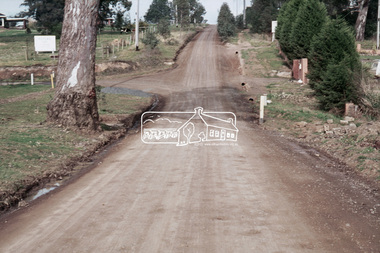
 Eltham District Historical Society Inc
Slide, Looking south along Bonds Road towards intersection of Montpelier Drive, Lower Plenty, 18 July 1972, 1972
Water drainage work undertaken by Eltham Shire Council in Bonds Road, Lower Plenty outside the Martin property opposite Montpelier Drive, July 1972 Note blocked table drains.35 mm colour positive transparency Mount - Agfacolor Service (Blue)Bonds Road (Martin property) 12.10 pm 18.7.72bonds road, drainage works, eltham shire council, infrastructure, lower plenty, martin property, montpelier drive -
 Greensborough Historical Society
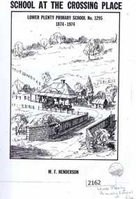
Book, School at the crossing place: Lower Plenty Primary School No.1295, 1874-1974. LP1295, 1874-1974
Book printed for the centenary of the opening of Lower Plenty Primary School, 1874-1974. Includes a short history of the founding and early years of the school as well as highlights from the first 100 years. A short history of Lower Plenty Primary School.Photocopy of book, 26 pages, illus. 2 copies lower plenty primary school -
 Eltham District Historical Society Inc
Slide, Pit on east side of Bonds Road, Lower Plenty, 18 July 1972, 1972
Water drainage work undertaken by Eltham Shire Council in Bonds Road, Lower Plenty outside the Martin property opposite Montpelier Drive, July 1972 Note rubbish excavated from pit.35 mm colour positive transparency Mount - Agfacolor Service (Blue)Bonds Road (Martin property) 12.10 pm 18.7.72bonds road, drainage works, eltham shire council, infrastructure, lower plenty, martin property, montpelier drive -
![View of the township of Golden Square / [by] Nicholas Caire, circa 1876](/media/collectors/550653872162f11fb04854aa/items/578340aed0cdd1176c6899f4/item-media/5783411dd0cdd1176c68c568/item-fit-380x285.jpg) Kew Historical Society Inc
Kew Historical Society IncPhotograph, Anglo-Australasian Photographic Company, View of the township of Golden Square, c. 1876
Nicholas Caire was born on Guernsey in the Channel Islands in 1837. He arrived in Adelaide with his parents in about 1860. In 1867, following photographic journeys in Gippsland, he opened a studio in Adelaide. From 1870 to 1876 he lived and worked in Talbot in Central Victoria. In 1876 he purchased T. F. Chuck's studios in the Royal Arcade Melbourne. In 1885, following the introduction of dry plate photography, he began a series of landscape series, which were commercially successful. As a photographer, he travelled extensively through Victoria, photographing places few of his contemporaries had previously seen. He died in 1918. Reference: Jack Cato, 'Caire, Nicholas John (1837–1918)', Australian Dictionary of Biography.An original, rare photograph from the series 'Views of Victoria: General Series' by the photographer, Nicholas Caire (1837-1918). The 60 photographs that comprise the series were issued c. 1876 and reinforced a neo-Romantic view of the Australian landscape to which a growing nationalist movement would respond. Nicholas Caire was active as a photographer in Australia from 1858 until his death in 1918. His vision of the Australian bush and pioneer life had a counterpart in the works of Henry Lawson and other nationalist poets, authors and painters.‘View of the township of Golden Square’ : Views of Victoria (General Series) No.57 : Albumen silver photograph | Photo on card with Title and Description on reverse | Mounted 24 x 30 cm; Photo 12 x 17 cm.On Reverse: ‘This Township is situated in the Bendigo district, on the road to Castlemaine, and although it is of little importance as a business town, is nevertheless of large importance in consequence of the great number of Quartz Reefs it contains. Almost every house is undermined, and large fortunes have been made by the proprietors. The Church in the distance is that of the Wesleyan body. It was in this township that gold was first discovered in the district of Bendigo.’nicholas caire (1837-1918), golden square (vic), bendigo (vic), gold mining, landscape photography - victoria