Showing 147 items
matching punt road
-
 Cobram Historical Society Inc... Cobram Historical Society Inc Old School Punt Road Cobram ...Round large stamping pad, used at local post office for multiple stamps. Post office 14, 15,16, 17.
 -
Cobram Historical Society Inc
Stamp
... Cobram Historical Society Inc Old School Punt Road Cobram ...Wooden Handled commercial stamp used.For Victoria Railways Commission -
Cobram Historical Society Inc
Woodwork wooden router
... Cobram Historical Society Inc Old School Punt Road Cobram ...Woodwork wooden router, -
Cobram Historical Society Inc
Stamp
... Cobram Historical Society Inc Old School Punt Road Cobram ...Wooden and brass commercial stampUnclaimed at Yarroweyah -
Cobram Historical Society Inc
Stamp
... Cobram Historical Society Inc Old School Punt Road Cobram ...Sodden and brass commercial stamp, insignia YarroweyahYarroweyah -
Cobram Historical Society Inc
Brown case
... Cobram Historical Society Inc Old School Punt Road Cobram ...Medium size brown suit case. Single brown leatherette handle. Double latch closures with 2 keys attached. Metal protectors on each corner of case. Interior lined with dark green fabric. Interior of lid with pocket section. -
Cobram Historical Society Inc
Stamp
... Cobram Historical Society Inc Old School Punt Road Cobram ...Wooden rubber stamp - commercialCobram Yarroweyah Trust -
Cobram Historical Society Inc... Cobram Historical Society Inc Old School Punt Road Cobram ...Stamp holder Circa 1930
-
Cobram Historical Society Inc
Ledger
... Cobram Historical Society Inc Old School Punt Road Cobram ...Commercial Ledger donated by Vern Wyatt who with his father, George and uncle Les Wyatt operated Cobram’s main motor repair and service garage on the east side of Station Street ( Opposite the now Car wash). -
Whitehorse Historical Society Inc.
Book, Place kicks to drop punts, 1989
A history of Mitcham Football Club from 1888 - 1988.A history of Mitcham Football Club from 1888 - 1988.A history of Mitcham Football Club from 1888 - 1988.mitcham football club, 1888 - 1988. -
Whitehorse Historical Society Inc.
Newspaper - Article, Every Picture tells a story, 12/07/1998
Article in 'The Age' Agenda, 12/7/1998 telling the story of the lost McCubbin painting 'Bush Idyll' which is surrounded by mystery. The painting had been missing for 60 years and first came to light in Britain in the late 1970's. In 1984 David Waterhouse, prominent punter and former bookmaker purchased the painting for $150,000 on the condition that he did not sell it for ten years. The painting was set in the bush near Blackburn Lake.artists, mccubbin, frederick, waterhouse, david, yarr, janette, dahl, roald, lloyd-webber, andrew, von guerard, eugene, abrahams, louis, mcintosh, h.d., lury, ralph, nerli, girolami, king, frank, cowden, tony, bond, alan, holmes, a court, robert, bill, blackburn lake sanctuary -
Whitehorse Historical Society Inc.
Article, Push to Punt Pokies, 2017
The Alliance for Gambling Reform has called for The Chase Hotel to close down its pokies.The Alliance for Gambling Reform has called for The Chase Hotel to close down its pokies after it was revealed that almost $16 million was gambled in a year.The Alliance for Gambling Reform has called for The Chase Hotel to close down its pokies.gambling, forest hill chase, chase hotel, forest hill, forest hill shopping centre -
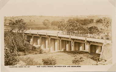 Kew Historical Society Inc
Postcard, Valentine Publishing Co Pty Ltd, New Yarra Bridge, Between Kew and Heidelberg, 1926-1930
Without bridges, Kew remained cut off from the City of Melbourne, only being accessible by Punt. Private and public bridges were constructed from the 1850s, beginning with the Hawthorn Bridge linking Bridge and Burwood Roads. A bridge across the Yarra at Burke Road was created as early as 1873. Since that first wooden bridge, a number of later bridges, typically on concrete pylons have been built, in 1926 and again during the 1970s.Angle view of the new Yarra bridge [ie. The Burke Road bridge] taken from the Kew side, showing the bridge’s structure. Trees line the river’s edge. In the distance can be seen a distant line of houses stretching to the horizon. The river appears to have an S-shaped bend beyond the bridge. The postcard, No. 227, was produced by the Valentine Publishing Co. Pty Ltd., of Queen Street, Melbourne.burke road bridge - kew (vic), bridges - kew (vic) -
![The Punt, Echuca / [by] Nicholas Caire, circa 1876](/media/collectors/550653872162f11fb04854aa/items/57825721d0cdd1176ce1789a/item-media/57825765d0cdd1176ce19829/item-fit-380x285.jpg) Kew Historical Society Inc
Kew Historical Society IncPhotograph, Anglo-Australasian Photographic Company, The Punt, Echuca, c. 1876
Nicholas Caire was born on Guernsey in the Channel Islands in 1837. He arrived in Adelaide with his parents in about 1860. In 1867, following photographic journeys in Gippsland, he opened a studio in Adelaide. From 1870 to 1876 he lived and worked in Talbot in Central Victoria. In 1876 he purchased T. F. Chuck's studios in the Royal Arcade Melbourne. In 1885, following the introduction of dry plate photography, he began a series of landscape series, which were commercially successful. As a photographer, he travelled extensively through Victoria, photographing places few of his contemporaries had previously seen. He died in 1918. Reference: Jack Cato, 'Caire, Nicholas John (1837–1918)', Australian Dictionary of Biography.An original, rare photograph from the series 'Views of Victoria: General Series' by the photographer, Nicholas Caire (1837-1918). The series of 60 photographs that comprise the series was issued c. 1876 and reinforced a neo-Romantic view of the Australian landscape to which a growing nationalist movement would respond. Nicholas Caire was active as a photographer in Australia from 1858 until his death in 1918. His vision of the Australian bush and pioneer life had a counterpart in the works of Henry Lawson and other nationalist poets, authors and painters.Views of Victoria (General Series) No.34; ‘The Punt, Echuca’; Albumen silver photograph | Photo on card with Title and Description on reverse | Mounted 24 x 30 cm; Photo 12 x 17 cm.On Reverse: ‘The subject of this illustration is the principal crossing-place on the River Murray at Echuca, as regards the ordinary road traffic from the district of Riverina, New South Wales. After the periodical floods, the Punt is found to be insufficient for the large traffic; but this inconvenience will not be found to occur again to any great extent, as the new Railway Bridge from Moama will considerably lessen the road traffic through the Township of Echuca.’nicholas caire (1837-1918), echuca (vic), landscape photography -
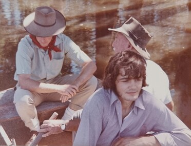
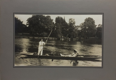 Kew Historical Society Inc
Photograph - John Duncan Brownlee and friends, Yarra River, The Artorium, 1920s
This mounted and framed photograph of a group of friends punting on the River Yarra has a number of historic and artistic associations. The photograph is primarily important as an informal photograph of the Australian baritone John Donald Mackenzie Brownlee (1900-1969), whose international career at the world's major opera houses from 1927 until his retirement in 1958 included singing at Melba's Covent Garden farewell in 1926, to recordings in the 1930s of a major series of Mozart operas in Glyndebourne Festival productions, conducted by Fritz Busch. Brownlee, born in Geelong, won the gold medal as champion vocalist at the South Street competitions in Ballarat in 1921. Moving to Paris in 1923 he began study with the French baritone, Dinh Gilly, making his operatic debut at the Trianon Lyrique in Montmartre in 1926. The most significant periods of his operatic career were with the Paris Opera from 1927 to 1936, and at the Metropolitan Opera from 1937 to 1957. After his move to Paris in 1923, he is recorded as revisiting Australia in 1928 as a member of the Melba-Williamson Company, and 24 years later in 1952. The photograph of Brownlee and the Gardners in a punt on the Yarra, while putatively dated to 1925, must be from earlier in the 1920s before his move to Paris, or later during the Melba-Williamson Company season. Before his move to Paris in 1923, Brownlee had lived in Belmont Avenue, Kew, where he must have developed a friendship with the Gardners. The photograph has additional artistic significance as it was produced at 'The Artorium', James Beament's design studio next to the Hawthorn Town Hall at 362 Burwood Road. With a home at 33 Uvadale Road (designed by Eric Nicholls, who managed the architectural practice of Walter Burley and Marion Mahony Grifffin from 1924 to 1932), Beament painted a number of significant murals for the Griffin practice, including those at the Capitol Theatre in Melbourne.A photograph of recreational activities on the River Yarra. The photograph is historically significant as a professionally produced photograph of the Australian operatic baritone John Brownlee, either before his move to Paris in 1923, or in 1928 during the Melba-Williamson Company operatic tour of Australia. The photograph has additional aesthetic significance as it was produced in James Beament's Hawthorn Studio - The Artorium - at 362 Burwood Road, next to the Hawthorn Town Hall.Framed photograph of John Duncan Brownlee, the Australian tenor, with Enid Gardner and friend in a punt on the Yarra River. Brownlee was born in Geelong but before his move to Paris in 1923, he lived for a period in Belmont Avenue, Kew. Three labels on reverse. 1. "John Duncan Brownlee, Operatic Star, originally of Geelong later resident of Kew at Belmont Av, on the pole. Also in the punt - Edith Gardner a friend. The Gardners lived on the east corner of Edgevale Rd. & Cotham. Approx. 1925." 2. "This picture is the property of Kew Historical Society 1/4/79". 3. Tel. Hawthorn 842 THE ARTORIUM ...."john brownlee (tenor), punting, recreation - yarra river (kew), james beament, the artorium -- 362 burwood road -- hawthorn (vic.) -
 Kew Historical Society Inc
Photograph, Burke Road Bridge, 1930s
Without bridges, Kew remained cut off from the City of Melbourne, only being accessible by Punt. Private and public bridges were constructed from the 1850s, beginning with the Hawthorn Bridge linking Bridge and Burwood Roads. A bridge across the Yarra at Burke Road was created as early as 1873. Since that first wooden bridge, a number of later bridges, typically on concrete pylons have been built, in 1926 and again during the 1970s.Sepia, faded photograph of the Burke Road Bridge linking East Kew and Ivanhoe. The previous bridge, constructed in 1926 was submerged beneath the flood waters in the 1934 mega-flood of the Yarra.burke road bridge (kew), bridges -- river yarra -
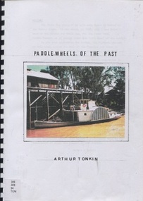 Surrey Hills Historical Society Collection
Book, Paddle wheels of the past
The discovery of inland waterways during the early settlement of Victoria and South Australia led to trade being plied up and down the rivers.An A4 80 page comb bound book.paddlewheels, paddlesteamers - murray river (nsw- sa), boats, punts, barges -
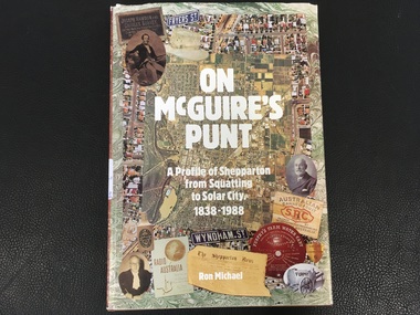 Port Fairy Historical Society Museum and Archives
Book, Ron Michael, On McGuire's Punt. A profile of Shepparton from squatting to solar city, 1838-1988
History of Shepparton's first 150 years. Including closer settlement, irrigation, multiculturalism.174p. : ill., non-fictionHistory of Shepparton's first 150 years. Including closer settlement, irrigation, multiculturalism.shepparton (vic.), history, book -
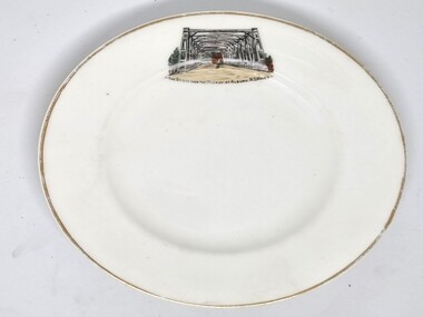 Wodonga & District Historical Society Inc
Souvenir - Souvenir Plate - Union Bridge, Albury, Hancock and Sons, c1930s
This item is from a collection donated by descendants of John Francis Turner of Wodonga. It is one of many souvenirs produced to represent landmarks in the Albury-Wodonga district. The first punt across the Murray River at Albury was established by Robert Brown in 1843. In 1861 the first Union Bridge was built. It was demolished to make way for the second Union Bridge which opened in 1898. This second bridge closed and was eventually demolished after the third and existing bridge was opened in 1961. Hancock and Sons, Stoke on Trent - Sampson Hancock, a prominent Wesleyan Methodist, started potting in 1857. In 1891 he established the business of Sampson Hancock & Sons. Sampson died in 1900 and the business was continued by his three sons - Jabez, Harry and Arthur. In 1935 the business was in financial difficulty and was made bankrupt. It was restarted as S Hancock & Sons (Potters) Ltd. and moved to the Gordon Works, Hanley - which was renamed the Corona Works. The restarted company was not a success and it finally closed in 1937, having been put into receivership on 23rd March. This information helps to establish provenance of this plate.This item comes from a collection used by a prominent citizen of Wodonga. It is representative of a items produced to represent historic landmarks or features of the district.Fine China round plate with gilt edge and image of the Union Bridge, AlburyBeneath image: " THE BRIDGE OVER THE MURRAY AT ALBURY, NSWALESalbury souvenirs, union bridge albury, albury-wodonga border, murray river bridges -
 Wodonga & District Historical Society Inc
Album - Ringer's River by Des Martin - Plate 23 - Plans for a ring-in at Nuggety track
Keiran, Artie Klinberg, and an old horse trainer named Tim Byrne combine to make friends with Grapeshot. Nightly they row across the river, feed him on oats, and train him. Their intention is to ring Grapeshot in for Smokey at the Nuggety Flat meeting where Klinberg will punt him well. Des Martin as Byrne. Lt. Col. Tony Hammett as Klinberg.The album and images are significant because they document literature written by a prominent member of the Wodonga community. The presentation of this precis was supported by several significant district families and individuals.Ringer's River Album Coloured photo Plate 23des martin, many a mile, ringer's river, northeast victoria stories -
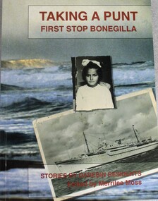 Wodonga & District Historical Society Inc
Book - Taking A Punt - First Stop Bonegilla: stories by Darebin residents, Merrilee Moss, 1997
Stories by Darebin residents recounting their personal immigration journeys and experience at Bonegilla Migrant Reception Centrenon-fiction Stories by Darebin residents recounting their personal immigration journeys and experience at Bonegilla Migrant Reception Centremigrant reception centre bonegilla, immigration australia, bonegilla -
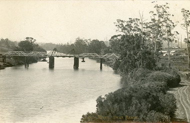 Lakes Entrance Historical Society
Postcard - Bridges, 1906
Postcard dated 3 December 1913, Bairnsdale, addressed to Mrs Brewer, Metung, Gippsland.Black and white postcard showing wooden lift bridge over Tambo River, Swan Reach, Victoria. Old punt visible at left bank under bank, thick vegetation on right bank, houses in right background above Metung Road.Tambo River, Swan Reachbridges, waterways -
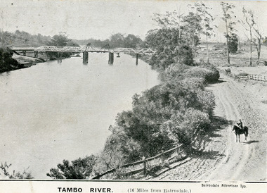 Lakes Entrance Historical Society
Postcard - Bridges, 1906
First timber road bridge over the Tambo River at Swan Reach officially opened 20 December 1905, after which punt was removed to BairnsdaleBlack and white postcard of the lifting bridge over the Tambo River at Swan Reach, Victoria. Man on horse standing on dirt road to Metung beside the river. Punt previously used to cross river visible against western bank of river.Tambo River (16 miles from Bairnsdale)bridges, waterways -
 Kew Historical Society Inc
Work on paper - Sepia Wash & Ink, G B Richardson, Creek and Old Watering Stage, on the Yarra, East Collingwood, 1854, 1854
Blind Creek was located between the Abbotsford Convent and what is now the Collins Bridge in Studley Park. In an 1858 map of East Collingwood by Clement Hodgkinson, in the State Library of Victoria, one can see how the creek was originally a significant landmark in Collingwood; remaining vacant land until a barrel drain enclosed it. The area was later filled in, surveyed and developed. The position where Blind Creek entered the Yarra was in the immediate vicinity of Hodgson’s Punt, which had linked Kew to the other side of the Yarra from 1839. The Punt was purchased by the Colonial Government in 1852 and was in use until the opening of the Studley Park Road (Johnston Street) Bridge in 1858 made its continued use redundantThe point of view selected by the artist for the watercolour is from the banks of Blind Creek in East Collingwood, looking across the Yarra to the Kew side of the river.Inscribed verso 'Creek and Old Watering stage, on the Yarra East Collingwood 1854 / Trees, stage, &c have long since disappeared / [Artist Signature] / FT 110 / Creek itself now being filled in 1903.gb richardson, blind creek - abbotsford, yarra river - abbotsford (vic) - kew (vic), colonial artists, australian art - 19th century, george bouchier richardson -
 Melbourne Tram Museum
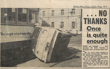
Newspaper, The Herald, “…No Thanks Once is quite enough”, 19/04/1973 12:00:00 AM
Newspaper clipping titled: “…No Thanks Once is quite enough” The Sun, Friday February 2, 1973 Photo and text Plumber Peter Mentha van and tram collide at corner of Punt Rd and Swan St, Richmond. No one was hurt, about $700 damage to van. Bongo van. Tram advertisement: “You ought to try it more often”. Mr Mentha did not seem amused by the invitation of an advertisement on side of tram: “You ought to try it more often”trams, tramways, accidents, punt rd, swan st -
 Melbourne Tram Museum
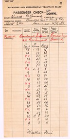
Document - Report, Melbourne & Metropolitan Tramways Board (MMTB), Passenger check - preprinted form 3/201, 15/08/1943 12:00:00 AM
Passenger check - preprinted form 3/201, dated June 1941, for the MMTB as a passenger check or passenger numbers. Completed for the Collingwood to Point Ormond Bus route, at Brunton Ave and Punt Rd of the Sunday 15/8/1943, football game Combined Services vs Essential Services at Richmond Ground - gives passenger numbers from 1.18pm to 3.08pm, completed by Inspector Ellis.On top edge in heavy black pencil "Easter Season 1941"trams, tramways, mmtb, public transport, buses, services, point ormond, collingwood, richmond, football -
 Lakes Entrance Historical Society
Postcard, Tambo Upper Punt, 1900 c
Faded postcard showing the river punt at Tambo Upper with horse and jinker on board also several people. View is looking east towards Redenbachs house and Swan Reach Bruthen road Tambo Upper Victoriatransport, waterways