Showing 420 items
matching quartz gold
-
 Federation University Historical Collection
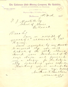
Document, Letter from Arthur Ballieu to Ballarat School of Mines, 10 March 1898
Arthur Baillieu, manager of the Talisman GMC of Craigie and Carisbrook wrote to Fred Martell, Registrar of the Ballarat School of Mines, concerning the disposal of gold sent to the Ballarat School of Mines for treatment.A handwritten letter written by Arthur Ballieu, with purple letterhead from 'The Talisman Gold Mining company, No Liability'. Hand written on page " 19th May 1898, F.J. Martell Esq The School of Mines, Ballarat Sear Sir, I am in receipt of an a/c from you date 13th inst for 7 pound 8 shillins, which I cannot understand. I already hold your receipt for the treatment of te 5 1/2 tons of quartz, the only charge against the coy at present is 10 shillings for your assay on the 6th inst. Awaiting your reply I am, Dear Sir Yours faithfully Arthur S. Ballieu Manager [inpc?] gold, ballarat school of mines, fred martell, fj martell, talisman gold mining company, arthur s ballieu, arthur ballieu, craigie, carisbrook -
 Federation University Historical Collection
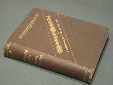
Book, Mines and Minerals: A Guide for the Australian Miner, 1885
This book was presented to Professor Ferdinand Krause of the Ballarat School of Mines by the co-author Felix Ratte who had taught Geology at the Ballarat School of Mines. Felix Ratte became mineralogist to the Australian Museum, Sydney.Hardcovered book with brown cloth cover. 341 pages with illustrations. Chapters in the book include Geology; Rocks and their Movements; Stratified Deposits; Mineral Veins and Lodes; Dynamics of Lodes; Filling of Lodes; Irregular Deposits; Alluvial Deposits; Physical Properties of Minerals; Compsition and Determination of Minerals; Noble Mineral; Silver and Lead; Quicksilver or Mercury; Haloids and salts; Quartz and Opal; Precious stones; assays and the use of Blowpipes; Special Assays for Gold and SilverFrontise page handwritten in ink: 'Prof. Krause from F. Ratte'mining, ballarat school of mines, geology, felix ratte, minerals, ferdinand krause -
 Federation University Historical Collection
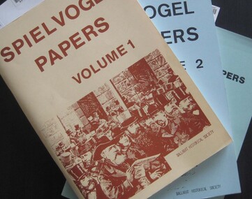
Booklets, Ballarat Historical Society, Spievogel Papers, volumes 1,2, & 3
Nathan Spielvogel was a local historian. The Spielvogel Papers consist of the articles he prepared for a series of weekly talks on Radio 3BA in 1936 and 1937. According to Alex Barnett there is a reference in the Spielvogel Papers to the moving of the bodies of diggers killed at the Eureka Stockade to the old cemetery on 26 November 1857.3 soft covered books with text relating to the history of Ballarat. .1) yellow cover .2) blue cover .3) green cover .1) includes topics such as Gold discovery, Eureka, Main Road, Ballarat Fire Brigade, Ballarat Benevolent Home, Buninyong, Burke and Wills Monument, Chinese in Ballarat, Dana Street School, Ballarat Hospital, Lost Trades of Ballarat, Ballarat Military, Mount Pleasant, Old Colonists' Club, Phoenix Foundry, Ballarat Post Office, Railways, Ballarat School of Mines, South Street Society, Martin Hosking, Charles Curnow Phillips, James Sainsbury, and William Cross Yuille. .2) includes topics such as Ballarat streets, bowls, cricket, football, hotels, Little Bendigo, Lake Wendouree, Ballarat Quartz Mines, Sebastopol, Ballarat Turf Club, Ballarat Zoo, water supply. .3) includes topics such as the Kohinoor Nugget, Eureka, Black Hill, Sebastopol, oddietown, Joe the bellman, Trades Hall, Lal Lal Iron, Ballarat Library, Yuille Creek, Martin Hosking, Stonewall Jackson, steeplechase, Lemonade Paddock, Ivey's Flour Mill, Salvation Army, Stick Jaw Davey, Unicorn Hotel, doctors, Alfred Bells, Ballarat School of Mines Museum (War Museum), Joseph Orange, Ballarat East Post Office.ballarat, speilvogel, nathan spielvogel -
 Federation University Historical Collection
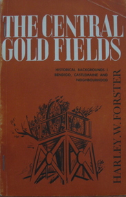
Book, Harley W. Forster, The Central Goldfields, 1969
Brown covered book of 80 pages. Topics include gold, McIvor diggings, Tarrangower goldfields, Maldon, quartz reefs, Chinese, land selection, Mt Alexander, Castlemaine, gold licence agitation, glossary. gold license, gold licence, castlemaine, goldfield agitation -
 Federation University Historical Collection
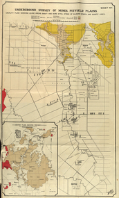
Book, Stanley B. Hunter, Report on the Pitfield Plans Gold-Field, 1901, 1901
Blue soft covered foolscap report with 15 plans and sections.pitfield, gold, mining, geology, pitfield plains, british banner, pitfield plateau, pitfield quartz and cement, woady-yalloak, queen of the plans, glenfine -
 Federation University Historical Collection
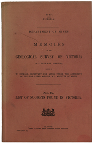
Book, Albert J. Mullett, List of Nuggets found in Victoria, 1912
Pink soft covered foolscap book of 67 pages listing the gold nuggets found in Victoria. The Book is no 12 in the 'Memoirs of the Geological Survey of Victoria' series. The listing of nuggets found in Victoria includes number of nugget, whether found in quartz or alluvial, weight, where found, depth, name of nugget. date found, finders, authority and remarks. 1360 nuggets weighing over 20 ozs are listed.geological survey of victoria, gold nuggets, e.j. dunn, w. dickson, peter mcbride, a. e. smith, tinworth's party, welcome stranger, ah chung, dalton's flat, lady hotham, lady don, lady barkly, needful, corinella mining co, w. kitt, p. flood, celeste lafranchi, bravo, w. passobi, mrs rowlands -
 Federation University Historical Collection
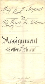
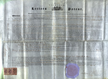
Document, Indenture Between Robert M. Serjeant, Joseph Flude and the Trustees of the Ballarat School of Mines regarding Letters of Patents for the Benefit of the Ballarat School of Mines, 1877, 04/03/1875
R.M. Serjeant was listed as a mining manager and Joseph Flude as a metallurgist. In 1875 they were both living in Ballarat. The patent number is A.D.1875, 4th March. No 2031. According to the patent the hearth of the furnace is in the form of a cone revolving horizontally. The feed is supplied to the apex of the cone by an archimedian screw. The crown of the furnace comprises a double covering or roof with an intermediate chamber for receiving heated air. The inner covering is pierced to admit of the heated air being brought into contact with the pyrites on the face of the revolving hearth. The discharge of the roasted substance is affected by means of a scraper at the base of the cone. It was claimed that this was a new mode of introducing heated air, and the exclusion of flame during the operation of roasting pyrites. The self-acting charge and discharge of the furnace and the peculiar construction of the hot air chambers, and the use of perforated bricks through which the supply of air is affected were also new. (http://patentsvictoria.net/002031.html) From the Goulburn Herald, 14 September 1878 "A feature connected with the school of mines is the yet unfinished pyrites works. The extraction of the gold from pyrites and the utilization for commercial purposes of other substances connected with pyrites are peculiarly important to Ballarat, because were a simple and inexpensive method devised there are millions and millions of tons of quartz that would then be made remunerative. With this thought in their minds two scientific gentlemen invented the school of mines self-acting rotatory furnace. This, for lack of funds, has not been completed as yet, but the amount in hand for the purpose is daily increasing, and it will eventually be an accomplished fact. It is in contemplation also to erect machinery shops in connection with the school, and it is purposed to con struct a steam-engine to do at once the work of the pyrites treatment and the ma chine room. A model shaft and mine too are being prepared for on the reserve, so that practical mining of the most thorough character may be taught on the ground.'Large indenture on red bordered vellum. The indenture was regarding a patent for the benefit of the Ballarat School of Mines. Letters Patent for an Invention for Roasting Pyrites to be called 'the Ballarat School of Mines self-Acting Pyrites Furnace" to Robery Malachy Serjeant and Joseph Flude. The large document is on a vellum type paper complete with stamps and seal. The document is signed by Acting-Governor William Stawell. Inscriptions and Markings Written on verso: "Date of Patent 4th March 1875 No 2031 Letters Patent for An invention for roasting pyrities to be called "The Ballarat School of Mines Self-acting Pyrities Furnace" to Robert Malachy Serjeant and Joseph Flude Melbourne, Victoriaballarat school of mines, serjeant, r.m. serjeant, robert m. serjeant, flude, joseph flude, patent, barry, redmond barry, rogers, judge rogers, bland, rivett henry bland, john airy, warrington rogers, establishment, indenture, legal, cuthbert, ballarat school of mines trustees, william stawell, john warrington rogers -
 Federation University Historical Collection
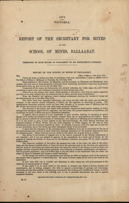
Booklet - Report, John Ferres, Government Printer, Report of The Secretary for Mines on the School of Mines, Ballarat, 1873, 1873
The following are listed as having pyrites treated at the Ballarat School of Mines: Louis Ballhausen, Alexander Millan, Tuckey Quartz Mining Co (New Zealand), Egerton Mining Company, Park Gold Mining Company, S. Livingston Learmonth, New North Clunes Mining Company, Malcolm Morris, Mr Seal.Five printed foolscap pages presented to both houses of Parliament in 1873. The report details budget, student numbers, examiners, candidate for examination, museum and rooms.ballarat school of mines, serjeant, r.m. serjeant, flude, joseph flude, richard gibbs, stawell, lynch, john lynch, r.s. mitchell, mitchell, bull, e. bull, bickett, j.m. bickett, parliament, louis ballhausen, alexander millan, tuckey quartz mining co (new zealand), egerton mining company, park gold mining company, s. livingston learmonth, new north clunes mining company, malcolm morris, seal, f. ive, rev. g.j. russell, p.c. fitzpatrick, j. m. bickett, b. bryant, n. kent, a. martin, p. matthews, j. robinson, j.m. troup -
 Federation University Historical Collection
Document, Letters Patent for an Invention for Roasting Pyrites, 1875, 1875
R.M. Serjeant was listed as a mining manager and Joseph Flude as a metallurgist. In 1875 they were both living in Ballarat. The patent number is A.D.1875, 4th March. No 2031. According to the patent the hearth of the furnace is in the form of a cone revolving horizontally. The feed is supplied to the apex of the cone by an archimedian screw. The crown of the furnace comprises a double covering or roof with an intermediate chamber for receiving heated air. The inner covering is pierced to admit of the heated air being brought into contact with the pyrites on the face of the revolving hearth. The discharge of the roasted substance is affected by means of a scraper at the base of the cone. It was claimed that this was a new mode of introducing heated air, and the exclusion of flame during the operation of roasting pyrites. The self-acting charge and discharge of the furnace and the peculiar construction of the hot air chambers, and the use of perforated bricks through which the supply of air is affected were also new. (http://patentsvictoria.net/002031.html) From the Goulburn Herald, 14 September 1878 "A feature connected with the school of mines is the yet unfinished pyrites works. The extraction of the gold from pyrites and the utilization for commercial purposes of other substances connected with pyrites are peculiarly important to Ballarat, because were a simple and inexpensive method devised there are millions and millions of tons of quartz that would then be made remunerative. With this thought in their minds two scientific gentlemen invented the school of mines self-acting rotatory furnace. This, for lack of funds, has not been completed as yet, but the amount in hand for the purpose is daily increasing, and it will eventually be an accomplished fact. It is in contemplation also to erect machinery shops in connection with the school, and it is purposed to con struct a steam-engine to do at once the work of the pyrites treatment and the ma chine room. A model shaft and mine too are being prepared for on the reserve, so that practical mining of the most thorough character may be taught on the ground.'Letters Patent for an Invention for Roasting Pyrites to be called 'the Ballarat School of Mines Self-Acting Pyrites Furnace' to Robert Malachy Serjeant and Joseph Flude. The large document is on a vellum type paper complete with stamps and seal. The document is signed by Acting-Governor William Stawell.Written on verso: "Date of Patent 4th March 1875 No 2031 Letters Patent for An invention for roasting pyrities to be called "The Ballarat School of Mines Self-acting Pyrities Furnace" to Robert Malachy Serjeant and Joseph Flude Melbourne, Victoriaballarat school of mines, serjeant, r.m. serjeant, robert m. serjeant, flude, joseph flude, richard gibbs, stawell, william stawell, pyrities furnace, philately, statute stamp, seal (victoria), ballarat school of mines self-acting pyrities furnace, ballarat school of mines self-acting pyrites furnace -
 Federation University Historical Collection
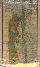
Map, Ballarat and Sebastapol Gold Mines, Late 19th Century
colored printed map on paper lined onto linen backingprinted "Rider & Mercer's Plan of the Ballarat & Sebastapol Gold Mines Scale 30 Chains to One Inch"gold mines, mine allotment map, mining leases, ballarat, sebastopol, rider and mercer, golden shaft co, prince of wales and bonshaw united, leviathan gold mines, holst and co, speedwell co, sebastopol plateau, rothschild co, tower hill co, south plateau, south star co, band of hop and albion consols, prince regent co, chenhall and co, despza, buninyong estate, one eye hully, winter's freehold, luplau plateau, e. morey, carrill's quartz -
 Federation University Historical Collection
Book, Glenfine South and South Berry Journal
This Book is associated with former Ballarat School of Mines Student Richard Squire (1875-1876). Gift of the Squire FamilyGreen water marked linen covered journal with maroon spine with red feint lined blue pages. Label on front cover is cream with black printing JOURNAL with handwritten DATA RISIS GLENFINE SOUTH -SOUTH BERRY G.S & S.B Hand written in black and red ink. Plan in back with scale 20 chains to one inch - Has an index. Handwritten on title page in black ink Address of sawmiller T. J. Brown, Mount Rowan D. W. Hambly 317 Ligar St, Ballarat J. Freeman, C/O Mrs H Simons, Lynch St, Footscray Sleemans Prescription for the bladder in 19009 Mixture No 55983 Tabloids No 55982glenfine south, south berry, sleemans, mining, gold mining, glenfine consols, reef, weights of quartz, blacksmiths tools, australian and eagle, davies south east reef drive, brawns, eaglehawk junction, simons letter, machinery, puddlng plant, poppet heads, winding plant, creswick, mosquito creek, frenchmans gully, spring hill, a. h. welsh, squire, petticoat gully -
 Federation University Historical Collection
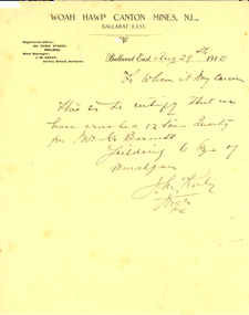
Letter - Document, Woah Hawp Canton Mines correspondence, 1910, 1910
Two pages with printed Woah Hawp Canton Mines N.L. letterhead, and handwritten section. .1) Certification of 12 tons of quartz crushed for Mr G. Barnett (signed J.M. Kerby) on Woah Hawp Canton Mines letterhead and dated 29 August 1910 .2) Certification of crushing yeilded 13 ounces of amalgam. (signed L.E. Trethowan, mine manager) on Woah Hawp No. 1 Gold Mining Company and dated 21 September 1910l.e. trethowan, j.m. kerby, woah hawp, woah hawp no. one gold mining company, woah hawp canton mines, chinese -
 Federation University Historical Collection
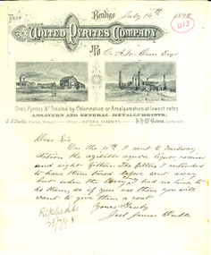
Letter - Correspondence, Letter on Bendigo United Pyrites Company Letterhead, 1898, 1898
"The United Pyrites Company's Works are situated about three quarters of a mile from Spargo Brothers, and are on the northern side of the Marong road, in Pinch-gut Gully. Two processes are followed at these works, viz., the amalgamating process and the treatment by means of chlorine gas. The latter is called the Newbery-Vautin system, and the mode pursued is that laid down by Mr. Cosmo Newbery and Mr Vautin, whose names have been given to the process. Mr. Edwards manages these works. Three reverbatory furnaces are used to roast the pyrites, which is weighed in the truck before being put into the furnaces. At this weighbridge a sample of each lot is kept, and if the yield is not equal to expectation, the works are carefully gone over to see where the fault occurs. Care is taken at the furnace to regulate the heat, otherwise the pyrites might slag instead of roasting evenly right through. An immense revolving furnace (made of boiler iron) was used at these works. It was found to be suitable for treating blanket sand, but was not a success for roasting coarse pyrites. The process of amalgamating by means of Chilian mills is the same in these works as at the Western Works, but the United Works are on a larger scale, and eleven mills are utilised. It is the chlorine gas process which is most interesting here. The gas is made from sulphuric acid, black oxide of manganese, and common salt, and the gas is introduced into huge vats, where it works its way through a filter of pieces of quartz and then through the bed of roasted pyrites lying above. The action of the gas transforms the gold into chloride of gold. This is easily dissolved in water, and in that form is drawn off into huge delf jars, where the use of sulphate of iron precipitates the gold to the bottom. A small battery—eight head of stamps in two boxes—is in use here to crush small consignments of stone sent for trial. Test crushings come from all the Australasian colonies, and even from India. The jars used are manufactured at Epsom, and some of the salt used is also of home manufacture, from the Salt Lakes on the Northern plains. Mr. Edwards took us over a new building in course of erection, and in which the chlorine gas is to be generated in the midst of the pyrites— a still further advancement in the new process. There is some very good machinery in this new building, and the tailings from the ordinary pyrites works will also be treated by this chlorine gas system, which has been found to work well at Mount Morgan, in Queensland. The purest of gold is obtained by this process, the gold passing in solution into a charcoal filter, from which it emerges in the shape of metallic gold. We saw some nice cakes of retorted gold at the works. One of 26oz. was from some New Zealand pyrites (2½ tons), and assayed over 23 carats. There were also cakes of Avoca gold, of silver, and of the tremulous amalgam." (The Argus, 4 February 1887)Two handwritten letters to the Ballarat School of Mines on Bendigo United Pyrites Company Letterhead.bendigo united pyrites company, pyrites, ballarat school of mines, j.j. deeble, joel deeble, joel james deeble, a.m. dean, fred j. martell, martell, s.h. cowan, letterhead -
 Federation University Historical Collection
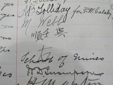
Book - Register, Berry Anderson & Co, Ballarat School of Mines Gold Entry Book. 1908-1976, 01/06/1908-01/12/1976
... , quartz, etc), Weight, Value, How Gold Treated, To whom delivered..., quartz, etc), Weight, Value, How Gold Treated, To whom delivered ...The Ballarat School of Mines had a model mine used by students, and to conduct assays for a fee. The Register of Gold Entry Book had to be kept by the Licensed Gold Buyer or Assayer under the Gold Buyers Act.Brown half leather bound register registering receipt of gold. Columns include date, nature of transaction (eg assaying/purchase), age, where employed, business (eg mining, fossicking, assayer, etc), Abode, Signature, Witness, Claim, Mining Division, District, Where Obtained, Character of Gold (eg alluvial, smelted, quartz, etc), Weight, Value, How Gold Treated, To whom delivered after assay or smelting, Date of Assayer's Certificate. ballarat school of mines, model mine, battery, assay, smelting, gold, robinson, frederick martell, r. callister, a. garrard, peter tong, lee sue, ah lung, chinese, f.w. calaby, ah kit, charlie ah lung, ah sung, ah chee, dep choon, charlie ah hing, frederick greaves, peter fong, george ah ki, ah hing, william mong, thomas bell and party, brown hill, dentist, amalgam, albert sydney sergeant, plumber, plumbing, george spence, plumber, commonwealth bank, j. hutton-jones, golden duke mining syndicate, blackwood, d.e.j. grant, eganstown, linton gold mining company, mining, d. bernard, g. peron, john page, david bernard, harry webb, ah fou, w.d. thompson, a.b. tolliday, m. webb -
 Federation University Historical Collection
Book - Scrapbook, Mining articles and notices, 1932 - 1936, 1934-1936
Hardcover minute book with charcoal green cover and red spine. Numerous newspaper clipping have been pasted onto the pages, most related to mining. The clippings include: 26 September 1932 - Castlemaine Goldmines - Best Prospects for Years 12 October 1932 - South New Chum Syncline Goldmines NL 30 November 1932 - New Morning Star Co. 19 February 1934 - Berringa Gold Syndicate NL 12 September 1934 - Murchison Goldfield - Triton Gold Mine 1935 - Great Poseidon 1935 1935 - Golden Age Amalgamated 11 February 1935 - Loloma Gold Mines NL 19 May 1936 - Beaconsfield Gold Mine in Tasmania 02 July 1936 - Fletchers Gold Mine 17 August 1936 - Lasseter's Reef. Kalgoorlie 17 November 1836 - Large Scale Operations at Ballarat 16 January 1937 - New Charlton Gold Area 19 January 1937 Golden Jacket Mine 26 January 1937 - Rich Quartz at Avoca April 1934 - Bendigo Mines Limited May 1934 - Church Centenary - St Luke's Campbell Town Interesting History (image) Tasmania 1932 - Evolution of Auto-Car - Cugnot's Steam Trolley (image) 1932 - Evolution of Auto-Car - Push Foot Schemes (image) 1933 - Evolution of Auto-Car - Hancock's Steam Omnibus (image) 1933 - Evolution of Auto-Car - First Petrol Car (image) 1934 - The Gold Standard - How Australia Forsook It August 1934 - Bolwarrah and Gordon's Amalgamated NL 23 August 1934 - Dunolly Gold Mines NL 12 September 1934 - Murchison Goldfield - Triton Gold Mine 08 September, Adelaide Advertiser - Australia's Heritage of Golden Days by Ernestine Hill 28 November 1934 - Chronicles of Early Melbourne by Garyowen 05 May 1936 - Bendigo Mines Director's Policy (image of E.C. Dyason) 30 June 1936 - Lamplough Mine 27 June 1936 - Gold Dredging Company for Newstead 30 May 1935, The Herald - Gordon Battery in Production 19 September 1936 - Wattle Gully reef - Payable Values at 655 Feet 30 June 1936 - Avoca Developments NL 16 July 1934 - Westralia Renown Mines NL Prospectus 07 November 1936 - Ballarat East Gold Field - English Company's Deal (Victoria United, Britania United, First Chance, Last Chance, Llanberris No 1, Llanberris No 2, Sulieman No. 1, Sulieman No. 2, Sulieman No. 4, North Normanby, North Woah Hawp, Woah Hawp Canton, Tinworth's, Prince Regent Consolidated) 07 November 1936 - Large Scale Operations at Ballarat (image of A.E. Llewellyn) * How an Australian Discovered the World's Greatest Goldfield -The Beginning of The Rand. bendigo mines, coolgardie discovery, melbourne - chronicles of early melbourne, ballarat gold field, mining, lasseter's reef, squatter, emperor mine, cassilis gold mining, granite, bendigo mines ltd, campbell town st luke's centenary, car evolution, dartmore, harcourt granite, murchison goldfield, ballarat mines, fanny bay, mail, rand, alex allan, raymond cahalin, mary dyer, robert fordham, a. garsand, augustus f. heseltine, j. owen james, william latham, k palmer, tinworth, theosanous, c. tompkin, castlemaine goldmines, coolgardie -
 Flagstaff Hill Maritime Museum and Village
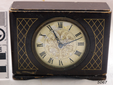
Clock, 1950
Westclox had a highly successful factory in Scotland situated in the Vale of Leven Industrial Estate, in Dumbarton, around twenty miles from the City of Glasgow. Westclox had originally planned to start production in Scotland in 1939 but the War intervened and it was not until 1948 that they were able to fully commission their factory in Dumbarton. Westclox Scotland produced its first clock on the 21st September 1948; a spring wound alarm with a 4 inch dial. The Westclox factory in Scotland was a full manufacturing plant with all their clocks assembled from start to finish with only the basic raw materials being brought in by outside suppliers. 95% of the staff were local people and the firm trained their employees from scratch to a high level of skill and had an annual apprenticeship for toolmakers and classes in horology. By 1949 Westclox Scotland were making 10,000 clocks a week, and by 1950, 1,000,000 clocks had been produced since its opening. No home in the Dunbartonshire Vale was without at least one Westclox clock, nor any raffle complete without a clock as one of the prizes! Many of these clocks are still around today. So successful was the Dumbarton factory that in the mid 1950’s Westclox had to expand into adjoining buildings. The factory then added watches to what they made as well as timing devices for other sectors. By the mid 1960’s, employment levels at the Scottish plant were around 1100. Over a third of the clocks manufactured in Scotland were exported to some 110 countries across the globe. Difficult times came in 1967/68 when 400 workers were laid off and the future of the plant was in doubt primarily due to cheap clocks from the then communist countries. However, strong petitions to the UK Government produced the passing of an anti-dumping law allowed production from the factory to pick up. In 1968 General Time was bought out by Talley Industries, which was best known as a manufacturer of timing equipment, such as factory time clocks to various industries. Westclox in Scotland enjoyed several boom years under the then Managing Director, John Santos. Westclox Scotland in October 1974 hosted a Space Seminar for the Astronaut, Neil Armstrong and British Astronomer, Sir Patrick Moore. Both visited the Scottish factory to promote the introduction of Quartz time-keeping. In 1976 the Westclox plant in Dumbarton became the Headquarters of General Time (International Operations) Ltd. John Santos retired from General Time and Westclox in the early 1980s and by 1988 the future of Westclox in Scotland was almost over. The advent of Quartz clock technology, developed largely by General Time for use in the Apollo 11 Command Module, resulted in the reduction of mechanical clock production and sales, and the factory fully closed in 1988.The Westclox factory building in Dumbarton has been converted and is now home to many thriving small businesses. The item marks a time when clock production in the United Kingdom was at it’s peak producing clocks for sale in over a 110 countries, they were keenly priced and available to all. The company had many innervation's during it’s life regards clock and later wrist watch making. In 25 years the factory had produced over 50 million clocks, yet it was perhaps inevitable with the advent of Quartz technology that was ironically evolved, largely by General Time for use in the Apollo 11 Command space Module, that would ultimately herald the end of the mechanical clock.Wooden bedroom alarm clock small painted brown with a criss cross pattern in gold and a white enamel face roman numerals & a glass front, clock case is of a fancy design. Inscribed on face "Made by Westclox Ltd Scotland" .flagstaff hill, warrnambool, shipwrecked-coast, flagstaff-hill, flagstaff-hill-maritime-museum, maritime-museum, shipwreck-coast, flagstaff-hill-maritime-village, clock mantle, clock, mantle clock, westclox ltd, horology, clock industries -
Federation University Historical Collection
Book, The Pyreness Shire, Avoca Shire Heritage Study 1864-1994, Volume 1, 1995
The Pyreness Shire, Avoca Shire Heritage Study 1864-1994, Volume 11) 21008.1 - Volume 1 - Pale blue bound book of 47 pages - Environmental History 2) 21008.2 - Volume 3 - Pale blue bound book - Geographical Locations of Individual Sites, alphabetically by Road Namewendy jacobs, karen twigg, nigel lewis/richard aitken pty ltd, shire of avoca, avoca heritage study, national estate committee (victoria), national estate grants program, victorian goldfields, pyrenees, moonambel, natte yallock, rathscar, barkly, redbank, crowlands, landsborough, the pyrenees shire, lexton shire, exploration and pastoralism, gold, water, farming, wine and fruit, towns and settlements, living in community, road and rail, extractive industries, conclusion, ballarat, major mitchell, djadja wurrung aboriginal group, djab wurrung aboriginal group, avoca, lamplough, chinese camp, alluvial mining, ironbark mine, upper homebush, homebush deep lead mine, avoca and district historical society, deep leads, quartz mining, percydale, hog's reef mine, avoca, dredging, hunter's home, moonambel c. 1890, mrs ellen allan, lamplough, the 1865 land act, flour milling, flour mill, moonambel. c. 1880, harkins farm, bung bong c. 1900, dairying, viticulture, navarre, schools, churches, cemetaries, wars, hotels, halls, sports, horse racing, country fire authority, maryborough-avoca railway, cobb and co -
 Federation University Historical Collection
Book, Ballarat School of Mines Assays and Analyses, 1897-1903, 1897-1903
Brown ledger with leather spine with bond copies of assays on very light, tissue like paper. Includes an alpha listing of customers and the page numbers where the associated assay and report is found. ballarat school of mines, mining laboratory, model mine, assay, frederick martell, alfred mica smith, j.m. bickett, g. desoza, figgis, gilpin, alex lamn, julius lazurus, john mann, james oddie, oldfield, peacock, thomas proctor, charles serjeant, w.c. shoppee, skilbeck, tulloch & co, john chaffy, cumming and smith and co, commonwealth mine, robert daly, dapto smelting co, duke of york co, ernest de beer, eureka company, r. emmett, p.w. fitzpatrick, first chance gold mning company, frenchmans reef company, f. folks, great birthday company, glenfine smith gold mining company, golden dyke extended, india rubber company, madame berry, victoria united gold mining company, black horse company, david melm, jame macarthur, new normanby company, william nicholas, alexander lambert, pitfield quartz and cement company, a.j. peacock, phoenix foundry, h. raven, c. serjeant, thomas smith, south star extended, h. strickland, edward h. shackell, w.d. thompson, union gold mining ompany, r. vale, walhalla pty, wallace butter factory, mining -
 Federation University Historical Collection
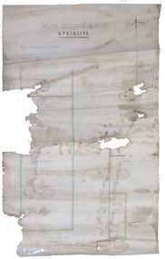
Plan, South Dividend Quartz Mining Company Plan
A hand drawn and coloured plan showing the position of the following gold mines in Steiglitz - South Dividend Company, the Marquis of Lorne Company, New Year's Reef, Malekoff Company and the Brazilian Reef.steiglitz, south dividend company, marquis of lorne company, new year's reef, malekoff company, brazilian reef, t. woolgrove -
Federation University Historical Collection
Book, George Brown, Prospectors' Guide (Victoria), 1936, 1936
... prospecting gold geology quartz reefs indicators ballarat indicators ...Brown soft covered book with pullout map showing auriferous areas of Victoria. prospecting, gold, geology, quartz reefs, indicators, ballarat indicators, miners' rights, mining leases, forest regulations, equipment, gold cradle, puddling machine, sluice box, whim, whip, california pump, cradle, mining, tools, mining laws -
Federation University Historical Collection
Book, D.C. Davies et al, Metalliferous Minerals and Mining, 1892, 1892
Brown hard covered, illustrated book of 518 pages. It includes a bookplate of the Ballarat Ironworkers' and Polytechnical Association Library Rules. The book was bequethed to the Ironworkers' Association by the late James Oddie.mining, minerals, quartz, nova scotia, california, germany, ural mountains, gold deposits, virginia, new england, new brunswick, brazil, australia, new south wales, mount morgan, new zealand, africa, statistics, india, phillipines, aruba island, silver, russia, nevada, ruby hill, nevada, utah, emma mine, nevada, colarado, red mountain district, colorado, yankee girl mine, arizona, mexico, peru, bolivia, chili\copper, south africa, italy, austria, norway, swedan, france, cornwall, dolcoath mine, sandstone, parys mines of anglesea, carnarvonshire, cardiganshire, wicklow, ireland, mississippi valley, wisconsin, lake superior, wyoming, cuba, jamaica, venezuela, south australia, york peninsula, flinders ranges, japan, tin, banca, malaysia, bohemia, saxony, sweden, spain, cligga point, rin lodes of cornwall, andalusia, belgium, shropshire, isle of man, durham, westmoreland, limestone, flintshire, dengigshire, canada, lead, zinc, siberia, hungary, silesia, sardinia, algeria, ireland, new jersey, iron, lancashire, missouri, michigan, superstitions, equipment, cages, stopes, winzes, timbering, ventilation, fans, drilling, boring, dynamite, electricity, blasting, horse whims, water wheels, boilers, petterson's elephant ore stamp, stamper battery, jogs, linkenbach table, panning, cradle, quartz mining, hydraulic mining, alluvia; mining, altai mountains, north wales, neugluck mine, freiberg, christbescherung mine, drei prinzen lode, miask, woodville, virginia, gongo soco, brazil, sierra nevada, california, st john del rey mine, brazil, leydenberg gold field, south africa, banket reefs, transvaal, kongsberg, norway, santa rosa mine, peru, huelva, spain, dolcoath mine, cornwall, parys mine, anglesea, waterbury copper mine, lake superior, copiapo, chilli, altenberg, saxony, whea; uny, cornwall, wast wheel mine. redruth, cornwall, cligga point, cornwall, old hewas mine, cornwall, hartz, germany, snailbeach mine, shropshire, llangynog, north wales, van mine, mongomeryshire -
Federation University Historical Collection
Book, R. Kirke Rose, The Metallurgy of Gold, 1898, 1898
T. Kirke Rose was an Associate of the Royal School o fMines, an Fellow of the Chemical Society amd ASsistant Assayer of the Royal Mint.Red hard covered, indexed book of 528 pages, with numerous illustrationsInside front :To Alfred John Hill with all good wished for a successful career from Alf Mica Smith Daniel Walker School of Mines Ballarat June 1900alfred mica smith, daniel walker, alfred john hill, mining, metallurgy, alloys, gold, cyanides, shallow deposits, water, quartz crushing, stamp battery, chilian mill, stanford's feeder, mercury, screens, concentration, hartz jigs, percusion tanle, roastin, butters mill, kennel, california, pyritic smelting -
 Federation University Historical Collection
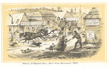
Print - Images, Unbound Images from Withers' 'History of Ballarat', c1987
Copies of all images from the 1887 version of Withers' 'History of Ballarat'. The images include copies of the Eureka Stockade reward posters. mail coach, eureka graves, ballaarat old cemetery, mining registrar's office, reward posters, lake wendouree, bakery hill, madame berry gold mining company, ballarat from bath's hotel, quartz crushing, black hill, horse puddler, pennyweight flat, aborigines, creswick, withers, william b. withers, history of ballarat -
Federation University Historical Collection
Document, Albert W. Strange, Ballarat Historical Park Description of Mining Processes & Equipment as a Guide to the Diggings and Quartz Mine, 1970, 02/1970
... sovereign hill ballarat historical park gold diggings quartz mine ...A guide to teh Sovereign Hill Diggings and Quartz MineSix typed pages including information onf the North Normanby Mine, deep leads at Ballarat, alluvial diggingsbert strange, sovereign hill, ballarat historical park, gold diggings, quartz mine, north normanby mine, cornish boiler, deep leads, ballarat east, windlass, alluvial diggings, wash paddock, windsail, shanty, quartz mining, puddling machine, hand whip, horse drawn whip, horse drawn whim, albert strange -
 Federation University Historical Collection
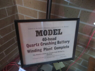
Sign, Model of 40 Head Quartz Crushed Battery
Framed sign relating to a 40 head crushing battery and winding plate of the model of the Band and Albion Consuls Gold Mining Company Ballarat, which was originally loaned by the Exhibition Commissioners to the Ballarat School of Mines Museum. band and albion consuls gold mining company, ballarat exhibition, ballarat school of mines museum -
 Bendigo Historical Society Inc.
Document - LONG GULLY HISTORY GROUP COLLECTION: BANKNOTES AND JAMES BEVERAGE
Typed copy of what appears to be a speech. Mentioned is that after 1910 the Commonwealth took over the minting it's own money. Gold mining was chosen for the one pound note and a Bendigo scene was chosen. The scene chosen shows boring operations in the Victoria Quartz Mine. The picture was taken by Vincent Kelly of the five figures but for engraving only three were shown. They were Mr W Healy, Mr J Smith and Mr James Beverage. James Beverage was a member of Bendigo's first fire brigade. He went to Beechworth for a demonstration and on the way home stopped at Christie's Hotel in Swanston Street. There was a fire at the hotel and Mr Beverage rescued Mrs Christie, her baby and a servant. At a later date Mr Beverage saved a woman from a burning building in Moore Street in Bendigo. He received the Royal Humane Society's Medal which is now housed at the Bendigo Fire Station in Hargreaves Street. In the City's formative years the area that deposited its rain water into the Long Gully Creek was considered to be in Long Gully and for many years the Victoria Quartz Mine deposited many thousands of gallons of water into the Long Gully Creek. Mr Steve Gibbons unveiled the plaque.bendigo, history, long gully history group, the long gully history group - banknotes and james beverage, victoria quartz mine, vincent kelly, shepard's bush, mr rickards, mr abraham, mr w healy, mr j smith, mr james beverage, south iron bark mine, rae's hill, sandhurst no 1 fire brigade, christie's hotel, mrs christie, royal humane society's medal, bendigo fire station, long gully history group, mr steve gibbons, department of environment water heritage, arts commnmoration of historic events and famous persons -
 Bendigo Historical Society Inc.
Slide - DIGGERS & MINING. THE GOLD ERA, c1880
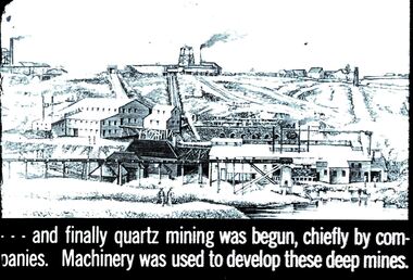
... Diggers & mining. The gold era. - - - and finally quartz... EDUCATION Tertiary goldfields hanimount Diggers & mining. The gold ...Diggers & mining. The gold era. - - - and finally quartz mining was begun, chiefly by companies. Machinery was used to develop these deep mines. Slide shows a deep mine layed out on a hillside. Markings 32 994.031 GOL:5. Used as a teaching aid.hanimounteducation, tertiary, goldfields -
 Bendigo Historical Society Inc.
Newspaper - JENNY FOLEY COLLECTION: LUCRATIVE
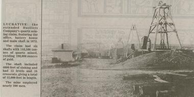
Bendigo Advertiser ''The way we were'' from 2000. Lucrative: the extended Hustlers Company's quartz mining claim, featuring the office, battery house and main shaft in 1875. The claim had six shafts with 144,500 tonnes of quartz mined, yielding 188,000 ounces of gold. The shaft included 4,000 feet of sinking and 16 crosscuts, giving a total of 12,000 feet in length. The mine employed nearly 200 men. The clip is in a folder.newspaper, bendigo advertiser, the way we were -
Bendigo Historical Society Inc.
Document - MINING IN BENDIGO COLLECTION: NOTES ON MINING IN BENDIGO
Handwritten notes on mining in Bendigo. Notes mention the size of the Bendigo Goldfield, the number of lines of reef and a brief history of goldmining in Bendigo.document, gold, mining in bendigo, mining in bendigo, notes on mining in bendigo, ravenswood sheep run, survey regiment, california hill state school, lansell's 222, mr lansell, camp hill school, high school, park mine (royal hustler's reserve no 1), memorial hall, city mine ( royal hustlers reserve no 2), mining stock exchange, beehive buildings, allan's walk, buckell & jeffrey, fortuna hustlers, great extended huatlers, garden gully united, mining exchange, garden gully united, wattle gully mine, ironbark mine, manchester arms hotel, extended hustlers mine, south belle vue, new chum railway, eureka extended, shenandoah, victoria quartz, the big 180, old chum, gt extended hustlers -
Bendigo Historical Society Inc.
Document - MINING IN BENDIGO COLLECTION: UNEARTHED QUARTZ CRUSHER
Typed notes mentioning the early pioneers of Bendigo Gold Mining. Some of them are: Messrs Ballerstedt, Wittschiebe, Luffsman, Roeder Lazarus, Kock, Hildebrandt, Bruhn,Miller, Annear, Wells, Rae,Jackson, Woodward, Sterry, Burrowes, Thorp, Heine, Holmes, Gould, Allen, Brooks, Watson and Geo Lansell. In 1911 a quartz crusher was unearthed in McCrae Street during excavations at the site of the new St.Kilian's Girls Club Rooms. It was used by the late Mr. James Irons. It was found at a depth of ten feet. Mr. Angus Kennedy, who believed that he manufactured the plant for Mr. Irons, said Mr. Irons used to crush very rich quartz from the Sheepshead Reef, south of the Big Blue Battery. Some years ago, a solid granite stone-crusher was seen at Diamond Hill. It was at the site of the old Diamond Hill Hotel. The Comet Reef was found by Mr. Driesslau, who found gold in an outcrop when he was shooting parrots. Also mentioned is the tunnel that goes right through Diamond Hill.document, gold, mining in bendigo, mining in bendigo, unearthed quartz crusher, messrs ballerstedt, wittschiebe, luffsman, roeder lazarus, kock, hildebrandt, bruhn, miller, annear, wells, rae, jackson, woodward, sterry, burrowes, thorp, heine, holmes, gould, allen, brooks, watson, geo lansell, bendigo advertiser april 28th 1911, st kilian's girls' club rooms, mr james irons, mr angus kennedy, sheepshead reef, big blue battery, diamond hill hotel, victoria proprietary ltd., comet reef, mr driesslau, diamond hill tunnel