Showing 612 items
matching river bank
-
 Tatura Irrigation & Wartime Camps Museum
Photograph, Goulburn Weir, 1890
... structures, middle distance, - river with tree'd banks beyond... Tatura the-murray Taken by photographer for State Rivers ...Taken by photographer for State Rivers and Water Supply Commission.Medium sized black and white photograph. Earthworks foreground, horse and dray lower right, men working on concrete weir structures, middle distance, - river with tree'd banks beyond, workmen's huts and house left of middle distancevictoria state rivers and water supply commission, goulburn weir -
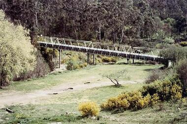 Greensborough Historical Society
Photograph - Digital Image, Aqueduct Greensborough, 1960c
... at the river bank.... at the river bank. maroondah aqueduct aqueduct pipe bridge ...The Pipe Bridge at Greensborough is a significant and highly visible part of the system. It was constructed to carry the wrought iron aqueduct pipes over the Plenty River. The use of wrought iron meant the pipes were 75% lighter than cast iron, with the bridge construction reflecting this innovation. Photograph of the Maroondah Aqueduct pipe bridge at Greensborough. The Pipe Bridge is 210 feet long, divided into 4 spans. The main girders are light lattice 11 feet deep and 11 ft 4 inches apart. The bridge carried two wrought iron tubular mains, 53 inches in diameter, supported at intervals by cross girders and chairs, placed between the main girders. The bridge is carried on braced cast-iron columns, 18 inches in diameter, set on concrete foundations, with a clear headway of 20 feet above the Plenty River. The eastern side of the bridge is reinforced with a bluestone abutment at the river bank.Digital copy of colour photograph.maroondah aqueduct, aqueduct pipe bridge greensborough -
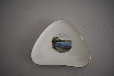 Warrnambool and District Historical Society Inc.
Artefact, Alka, Dish, Mid 20th century
... is a coloured sketch/photograph of the Hopkins River in Warrnambool... in the mid 20th century. Tourism in Warrnambool Hopkins River ...This souvenir dish has been made by the German firm of Alka. The name comes from the surnames of the two proprietors, Alboth and Kaiser. This type of dish was made between 1938 and 1958. Tourism has been an important industry in the Warrnambool area for over 100 years and souvenir dishes of this kind were a popular buy by the visiting tourists. The dish features a scene from the Hopkins River, a fishing and recreational area in Warrnambool since the early days of European settlement. Souvenir dishes such as this one can be sometimes found in local second hand and opportunity shops. This dish is of interest as an example of the high-quality souvenirs bought by local tourists in the Warrnambool area in the mid 20th century.This is a china dish made in a rounded-edged triangular shape. The rim is gilt-edged. In the centre of the dish is a coloured sketch/photograph of the Hopkins River in Warrnambool (Clifton Banks region). ‘Warrnambool Hopkins River’ ‘Alka Bavaria Germany’ tourism in warrnambool, hopkins river, warrnambool, history of warrnambool -
 Bendigo Historical Society Inc.
Postcard - Alice McGregor Postcard Collection, 1900 - 1920
... , Victoria. Banks of the river has shrubs in flower. ... of the Yarra River at Healesville, Victoria. Banks of the river has ...Alice McGREGOR Born: 1908; unknown parents. Possibly adopted by the Salter family? Electoral Roll 1936: Highland Terrace Kangaroo Flat. Alice Mary Salter and William Robert Salter living together; presumed to be sister and brother. William Robert Salter was killed in a MVA in Bendigo in 1937 aged 26. In Victoria in 1938, Alice Mary Salter married James Thomas McGregor (born Victoria 1917, died Victoria 1983, buried Fawkner Cemetery) Lived: 1968; 22 Wade Street Golden Square Alice McGregor Died: 1999 aged 91 at Anne Caudle Centre, Bendigo Buried: Kangaroo Flat Cemetery See additional research. Postcard Album of Alice McGregor contained 86 post cards.Postcard Album of Alice McGregor containing 86 post cards. See 1400. Colour photo of the Yarra River at Healesville, Victoria. Banks of the river has shrubs in flower. Addressed to Miss A. Stapleton, Arcade, Bendigo Post office cancellation stamp dated 18.11.05, Melbourne postcard, collector, alice mcgregor -
 Lakes Entrance Historical Society
Photograph - Snowy River, Tambo Shire, 1994
... , showing a river flowing between rocky banks, densely forested... photograph of the Snowy River near The Basin, showing a river flowing ...Also second identical copyColour photograph of the Snowy River near The Basin, showing a river flowing between rocky banks, densely forested hills rising on both sides and into the far distance. Buchan Victoria topography, waterways -
 Kiewa Valley Historical Society
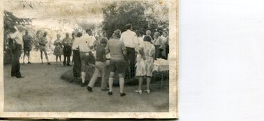
Photographs x 2 - Afternoon tea visit to Towong Hill
... bricks made from local clay dug from the river bank... from local clay dug from the river bank, to be the family home ...Towong Hill Homestead is a 110-year-old Federation style mansion situated on a rock outcrop, with views of about 260 degrees. It was built over 2 years by grazier Walter Mitchell from bricks made from local clay dug from the river bank, to be the family home for his new bride Winifred. They established their home in 1904. After the death of Walter in 1917, Winifred relocated her family, but the homestead remained in the families hands. In 1935, Thomas Mitchell (1906-1984) returned home to Australia, a successful Lawyer, and married city girl, Elyne Chauvel, and settled himself back at his childhood home, Towong Hill. Thomas was a world champion slalom skier, had been a prisoner of the Japanese at Changi, and was elected for the Country Party in 1946 and served as attorney-general in the McDonald government. His wife Elayne (1913-2002) is best remembered for her Silver Brumby series of novels for children. But Elyne also wrote a substantial number of non-fiction works about the Snowy Mountains. Photographs demonstrate local Kiewa Valley residents enjoying a community visit to the historic homestead at Towong Hill which holds significance to the early history of the area. Also demonstrates a pictorial history of social activities undertaken during this period2 black and white photographs mounted on buff card. Kiewa Valley residents attending afternoon tea at Towong HillHandwritten in black pen underneath photo - T.W.Mitchell Towong Hill. Afternoon Teat w mitchell, towong hill, kiewa valley -
 Orbost & District Historical Society
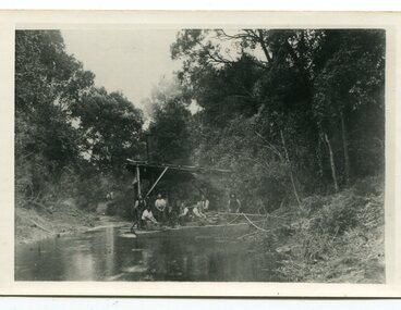
black and white photograph, C1890
... Wilkinson. The system used was to use a tree on the river bank... Wilkinson. The system used was to use a tree on the river bank ...This snagging team is on the Brodribb River, east of Orbost. The Brodribb bridge can be seen in the background of the Photograph. The Snowy River was used for commercial navigation after 1880 and extensive de-snagging A shipping company was formed in 1880, poling barges upstream until the removal of large trees and branches that had fallen into the river was carried out to make the river upstream of Marlo easier to navigate. "The snaggers played an important part in making the river free for transport. By 1880 Captain Collins, R McNair engineer, J McNair and the two Winchesters were at work with a punt on the Snowy and Brodribb. Mr. Jim Winchester took charge soon after. Early snaggers were Johnston, J Renton, Nat Lynch, John Drew, Hatton, J Scott and Harry Wilkinson. The system used was to use a tree on the river bank as a lever and with heavy manila ropes, slowly to haul the snags out. They were piled up around a tree and burned when dry. The snaggers lived in a row of cottages in Snaggers’ Lane." (info. John Phillips Newsletter March 2004)The snaggers played an important role in the early settlement of the Orbost / Marlo district helping bto open it up to commercial shipping.Two copies of a black / white photograph of nine men on a snagging boat, a flat-bottom barge. In the background is a bridge.on back - "Snagging boat on Brodribb with R.McNair"snaggers-brodribb-river snagging-east-gippsland transportation -
 Orbost & District Historical Society
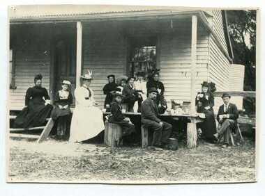
black and white photograph, Green, O. S, April 1897
... along the river banks, churning their way almost twenty miles... of Marlo, and the farms along the river banks, churning their way ...This photograph shows the Richardson family having a picnic on the verandah of Captain McNeil' house at Marlo - April 1897. Snowy River Shipping Company formed in 1880. They were soon shipping produce (mainly vegetables) from the area to Melbourne. The Snowy River Shipping Company was formed by Mr Henry James during the 1880s, with Captain McNeil as master. Captain Hegarty was the shipping agent at Marlo. Towing a line of small barges these paddle steamers plied their trade between the port of Marlo, and the farms along the river banks, churning their way almost twenty miles upstream to a landing beside what is now Frank Richardson’s property. On these trips, the barges carried mail and supplies to the townspeople and farmers, loading their produce, mostly maize, on the return trip to the coast. The coming of the railway in 1915 spelt the end for the little river boats. ( ref. F. W. RODWELL in the “Snowy Review”) Frank Richardson 1877-1950 was a sawmiller at Tabbara and helped build and run paddle steamer "Curlip"as engineer. Captain McNeil was an always cheerful Marlo identity and local children had many times sailing with him on the river. Captain McNeil with tug went out through the entrance and brought in the schooners.This item is associated with the Richardson family, early settlers of the Orbost district.A black / white photograph of a group of people having afternoon tea on the end of a verandah of a wooden house. All are seated.on back - " The Richardson family picnic at Marlo"richardson-family-orbost-marlo mcneil-captain -
 Port Fairy Historical Society Museum and Archives
Photograph, Alex Wilkins, c1940's
... showing Cox Street, William Street,Lower half of Bank Street River...,Lower half of Bank Street River and sea. The Gas works ...This photograph depicts Port Fairy streets in the 1940's showing Cox Street, William Street,Lower half of Bank Street River and sea. The Gas works are visible on Cox StreetThis photograph taken in the 1940's is significant because of the detail of that is shows regarding the set out of the streets and the vacant landblack and white photograph of the streets of Port Fairy2 stamps - ALEX WILKINS Photographer Warrnambool, Mrs O.G. Powell Phone 883 Port Fairy.( No 6 set over Sect 4) 4-6 streets, moyne river, port fairy, cox street, william street, gas works -
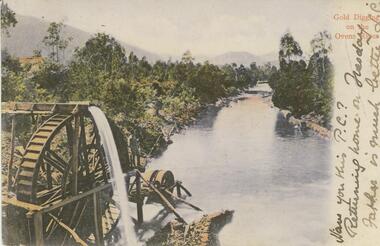 Bendigo Historical Society Inc.
Postcard - GLADYS DEAN COLLECTION: POSTCARD, 1906 - 1908
... on a platform looking over the river. The banks are thickly treed... standing on a platform looking over the river. The banks ...Coloured photographic postcard with a 2cm white border on right hand side depicting gold digging on the Ovens River. Aspect is taken from behind a waterwheel with a man standing on a platform looking over the river. The banks are thickly treed and mountains can be seen in the distance. The words Gold Digging on the Ovens River are printed in red on the margin and handwritten in black are the words Have you this PC? Returning home on Tuesday Father is much better L.C. On the reverse card is addressed to Miss R Dean 'Esmond" Golden Square Bendigo.44140postcard -
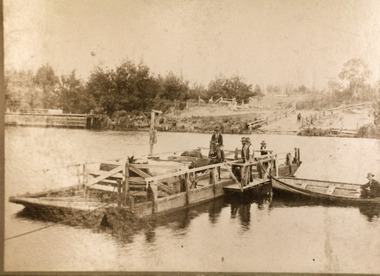 Lakes Entrance Historical Society
Photograph - Johnsonville Punt, Hancock, Phillip, 1920
... on far bank of river. Johnsonville Victoria... boat tied to punt. Jetty near landing on far bank of river ...Also black and white 10 x 15 cm copy donated by M Holding January 2012Sepia toned copy of a postcard showing the punt at the Tambo River, one man on horse, three men standing, cattle penned on punt, one man in rowing boat tied to punt. Jetty near landing on far bank of river. Johnsonville Victoria waterways, transport, animals, boating -
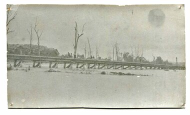 Orbost & District Historical Society
black and white photograph, January 1934
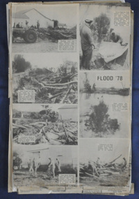
... , 1971 and 1978. It is recorded that the Snowy River broke its..., 1971 and 1978. It is recorded that the Snowy River broke its ...Orbost has been subject to major floods throughout its history, such as those which left the town isolated in 1934, 1952, 1971 and 1978. It is recorded that the Snowy River broke its banks and flooded the flats 104 times between 1884 and 1978. Extensive flooding in Eastern Victoria during June 1978, caused widespread damage to roads, road closures and hazards to traffic, particularly over the Queen's Birthday holiday weekend.This is a pictorial record of a significant event in Orbost's history.A very faded black / white photograph of flood water under the railway viaduct at watt's Gulch.orbost-flood-1934 railway-viaduct-orbost -
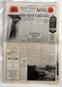 Orbost & District Historical Society
newspaper, Snowy River Mail, June 14 1978
... , 1971 and 1978. It is recorded that the Snowy River broke its..., 1971 and 1978. It is recorded that the Snowy River broke its ...Orbost has been subject to major floods throughout its history, such as those which left the town isolated in 1934, 1952, 1971 and 1978. It is recorded that the Snowy River broke its banks and flooded the flats 104 times between 1884 and 1978. Extensive flooding in Eastern Victoria during June 1978, caused widespread damage to roads, road closures and hazards to traffic, particularly over the Queen's Birthday holiday weekend.Since 1890 the Snowy River Mail has been the local newspaper of the Orbost district.This local paper has been the means by which readers in Orbost were able to learn about newsworthy events and issues in their local community for over a century. This paper is a contemporary record of a significant event in Orbost's history of flooding.A newspaper, Snowy River Mail, which contains black / white photographs of the 1978 floods in Orbost.orbost-floods-1978 -
 Orbost & District Historical Society
newspaper clippings, June 1978
... , 1971 and 1978. It is recorded that the Snowy River broke its..., 1971 and 1978. It is recorded that the Snowy River broke its ...Orbost has been subject to major floods throughout its history, such as those which left the town isolated in 1934, 1952, 1971 and 1978. It is recorded that the Snowy River broke its banks and flooded the flats 104 times between 1884 and 1978. Extensive flooding in Eastern Victoria during June 1978, caused widespread damage to roads, road closures and hazards to traffic, particularly over the Queen's Birthday holiday weekend. These newspaper articles are contemporary records of a significant event in Orbost history.A collection of black/white newspaper clippings relating to the 1978 flood in Orbost. Some are original articles. others are photo-copies. They appear to be from the Snowy River Mail newspaper.floods-orbost-1978 newspaper-articles -
Glenelg Shire Council Cultural Collection
Photograph - Contact Print, 1900s
... negatives. Top: 4 men, 2 women picnicking on bank of river/creek... on bank of river/creek. Bottom: Tennis court in foreground ...Sheet of 2 black and white contact prints from glass plate negatives. Top: 4 men, 2 women picnicking on bank of river/creek. Bottom: Tennis court in foreground. Portland Tennis Club pavilion with numerous people in and to one side, at Botanic Gardens. Dress late 19th, early 20th century.Front: Bottom - PTCP PORTLAND - white printportland tennis club, botanic gardens, recreation, tennis, sport -
Glenelg Shire Council Cultural Collection
Photograph - Contact Print - Portland, Victoria, 1970s
... setting. Bottom: 3 men and 3 women standing on bank of river.... Bushland setting. Bottom: 3 men and 3 women standing on bank ...Sheet of 2 contact prints from glass plate negatives. Top: Group of people on and near a bridge over creek. Bushland setting. Bottom: 3 men and 3 women standing on bank of river. Surrounding area flat, almost treeless. Sandy soil. People dressed in fashion of late 19th, early 20th century.photography, contact print, bushland, glenelg shire -
 Wodonga & District Historical Society Inc
Map - Boorgunyah - "The Town that never was"
... the workers at the river port of Red Bank when the paddle steamers... at the river port of Red Bank when the paddle steamers plied the Murray ...At the height of the river trade, there was a town surveyed and laid out, and streets were named. This town was to house the workers at the river port of Red Bank when the paddle steamers plied the Murray River as far as Albury, carrying produce such as wool and wheat to the various towns along the river in the 1800s. As the river trade died away, this town never went ahead – one might say, “The town that never was.” A lone gum tree stands on the site today.This item is significant because it documents plans which were made for the early development of Wodonga.A black an white map depicting the proposed location of the township. The map is based on a sketch and is not to scale,early wodonga, boorgunyah - "the town that never was", wodonga heritage -
 Federation University Art Collection
Painting - Artwork, Artwork by Daphne Wallace, 2006
... on the river bank, she escaped back to her people. They knew she... kidnapped her and kept her in a cave on the river bank, she escaped ...Daphne WALLACE (1964- ) Gomaroi, Ullaroi, Wurralli, Muralli Country Wallace is a Gamilaroi/Ullaroi-Yuwaaliaay artist whose intensely coloured and textured abstract and pictorial paintings are interpretations of the Yuwaaliaay stories passed down to her by her grandmother. They are evocative of her spiritual and emotional attachment to her home in Lightening Ridge.Daphne WALLACE Gomaroi, Ullaroi, Wurraili, Muraili country Artist's statement: This painting tells of many different stories, most of them I knew growing up and some were told to me since working on the Bubbles of the Surface Project. ... Reading this landscape through Murri / Murdi eyes and our relation to country. In the top, Yurri Yurri women/people, Rainbow serpents the other side of Coocoran Lake, Bunyip waterhol near Angledool, Ants nest believed to be where Baiame laid his tow wives, where the ants ate off the slime and brought them back to life, mining fields around Lightning Ridge, Bush tucker such as bumbull, burrigan, nappan, greewee, snotty gubbuls. In the middle, Gurra the crocodile, Gurra the crocodile himself, when Baiame killed him to retrieve the two wives, a rainbow shone no him and his scales turned inot opals, left to the Narran Lake was where Baiame sat down and left his bottom imprinted in the rock. he got up and moved onto the blue mountains where his wives gave birth to the three sisters. At the botttom of the painting, Walgett council dug up two old Kings sitting up face to face with their legs crossed, with their Tin King plates around their necks; Their head bands of kangaroo teeth were still inbedded in their skulls. The water dog stories are at spots along river "don't go down thereon the bend (Namour Researve River) the water dog witll get you" Nan used to tell us. It is believed that the water dog makes whirlpools and will drown you. He makes a druming sound, which can be heard along the Namoir, Barwon, Darling, Gwydir, Mihi and the Narran River; and the Duck is part of the creation story, with the twin platypus. It tells how the water dog kidnapped her and kept her in a cave on the river bank, she escaped back to her people. They knew she was bingal therefore vanished her fro that region, she travelled to New England region giving birth to twin platypus.daphne wallace, aboriginal, gippsland campus, churchill, gomaroi, ullaroi, wurraili, muraili -
Glenelg Shire Council Cultural Collection
Photograph - Contact Print - Scenes of Portland, Victoria, 1970s
... ) River, bush close to banks both sides (j) Botanic Gardens (k...) Fawthrop Lagoon (g) sailors (h) Post Office (i) River, bush close ...Sheet of 12 contact prints of rephotographed photographs: (a) 5 young women on dam wall (b) sailors (c) Bentinck Street, looking north from Post Office (d) Julia Street looking east from Percy Street (e) Railway line and Duttons (Nuns) Beach towards Whalers Bluff (f) Fawthrop Lagoon (g) sailors (h) Post Office (i) River, bush close to banks both sides (j) Botanic Gardens (k) Town and Port of Portland reproduced from III London News (l) North side, Julia Street looking west, Bank AustralasiaFront: (c) Bentinck Street approx. 1900 (d) Julia Street, portland Nicholls (h) Portland Post Officeportland scene, street scene, photography, portland harbour, portland seafront, julia street -
Glenelg Shire Council Cultural Collection
Photograph - Sheet of 12 contact prints - Various Portland and local surrounds buildings and landmarks, c. 1970
... ) Picnic on banks of river (j) Henty Bay (k) Man holding two bikes... Customs House (h) Yankee Doodle corner (i) Picnic on banks ...Sheet of 12 contact prints of rephotographed photographs: Identifying numbers 5721 a, b, c, d, e, f, g, h, i, j, k, l (a) Fishing party, flat rocks Bridgewater (b) Dutton Way (c) Julia Street (d) Steam train (e) Bentinck Street corner (f) Bridge across Salt Creek 'Kingsley' in background (g) Bentinck Street railway station from Customs House (h) Yankee Doodle corner (i) Picnic on banks of river (j) Henty Bay (k) Man holding two bikes Wellington Road/Bentinck Street (l) same as (h) - Bentinck Street railway station from Customs House -
 Eltham District Historical Society Inc
Photograph, Hume and Hovell passed here at Seymour 28 Oct 1824, Spring Excursion, Hume and Hovell's 1824 expedition (Part 2), 26 October 1997, 26/10/1997
... the Goulburn River near Molesworth where banks were high, water deep... the Goulburn River near Molesworth where banks were high, water deep ...[article by Diana Bassett-Smith in EDHS Newsletter No. 117, November 1997:] MONUMENT HUNTING THE HUME AND HOVELL WAY - Sunday October 26 1997 dawned bright and very warm. Some twenty-five members, complete with picnic baskets, met outside the Eltham Library awaiting the Cobb and Co. large coach which would be taking us on the second leg of our travels along the route of the early explorers Hume and Hovell. Stephen West was our very good driver for the day. He would be guided around the circuitous route by Russell Yeoman who had made a detailed study, not only of the intended route, but of the story of these two explorers. During the trip Russell regaled us with poetry, quotations from the Journals and the History of the Shire of Seymour, "The New Crossing Place" by Martindale, 1982, (now Mitchell Shire due to the recent amalgamations). We headed towards the Hume Highway via Greensborough and Cooper Street and proceeded north to our first stop, noting on the way Monument Hill in the distance which is near Kilmore and, according to Russell, well worth the effort to visit as the view across the valley is magnificent. Past Sunday Creek Valley, Mt Piper and Mt Disappointment, all traversed and noted and named by them. We passed through Tallarook, then onto Seymour where we took photos of the monument telling us that Hume and Hovell had passed through on the 28th of October 1824. We also deviated down Hume and Hovell Road viewing deer and emu farming and the Bellbourie property now a sanctuary. Leaving Seymour behind we travelled up the Avenel Road to the Avenel monument, pyramidal in design of four reducing square blocks with a sharply pointed peak, erected in 1924 in memory of the 1824 exploration. The day was warming up and the countryside showing the dryness of the current drought. A parallel note had been made in their journal too of 1824 of the drought appearance of the country they were traversing. At Seven Creeks, Euroa we stopped for some minutes to check the monument placed 20th November 1924 to commemorate their passage on the 29th December 1824. More photos. Russell had pointed out the abrupt termination of the distant ranges which is noted in their journal. The next monument is beside the road at the entrance to Honey Suckle Creek Caravan Park, Violet Town. The squarish shaped monument some eight feet high is topped with a simple steel cross, and was to mark the date of 28th December 1824 and built for the 20th November 1924. By now it was 12.20 and nearly lunchtime as we drove along the Warranbayne Road to Roach's Road, monument hunting without success. Though there is a large, what appears to be an old timber sign which was hard to read, maybe this was the lost monument. In many of the paddocks hay had been cut and baled or was being cut, what a contrast to the rugged country they had passed through which was smoky from the fires of the natives burning off. By 1.00 pm we were at Benalla and pulled up beside the park where abundant beds of roses filled the air with their scent and the smell of barbecued food twitched the nostrils whilst the cheerful sounds of other picnickers could be heard throughout the park. We left the bus and collected up our picnics, dispersed to the various tables and enjoyed the shade from the various European trees. 2.00 pm and we were on the road again driving along the Benalla, Mansfield, Yea road. The Swanpool monument states that they passed four miles south and returned three miles north. Then we stopped at the Barjarg monument which notes that they camped near this spot. It is again a pyramidal monument and this time topped with a steel arrow indicating their route of the 29th November 1824. Half an hour later we came to another monument, again with a steel arrow marker on top and the plaque dated the 2nd of 12th 1824. Erected on the 12th of 12th 1924. "They blazed the way that we might inherit the land." Another square based and needle topped monument appeared at Yarck near Yea and this plaque records the date of 3 December 1824. Near McGuigans Road Russell related that the expedition had lost a dog but it had found them next day, the dog was apparently torn by a kangaroo. A short while later Russell reminded us here of the problems they encountered in crossing the Goulburn River near Molesworth where banks were high, water deep and wide. "Good coat of grass but quite dry due to drought". At Yea we stopped for afternoon tea and raided the last of our picnics and looked at the monument to their journey of 1824, situated at a corner of the gardens near the bowling green. No photo – we were out of film. We returned home via Kinglake West and Whittlesea past the Yan Yean Reservoir, not full. 5.00 pm back at Eltham we emptied out of the bus and everyone, including Joan Cole, collected their things, Joan also had the major souvenir of the day, a large carp she had picked up from the river bank, her cat was in for a great feast. The day was made so interesting by the informed commentary which Russell provided. His background knowledge of the route and nature of the journey could only have come from many hours of reading and driving the area. Thank you to Russell and to everyone who made the day so informative and pleasurable. Colour photographactivities, hume and hovell, monument, seymour -
 Eltham District Historical Society Inc
Photograph, Spring Excursion, Hume and Hovell's 1824 expedition (Part 2), 26 October 1997, 26/10/1997
... the Goulburn River near Molesworth where banks were high, water deep... the Goulburn River near Molesworth where banks were high, water deep ...[article by Diana Bassett-Smith in EDHS Newsletter No. 117, November 1997:] MONUMENT HUNTING THE HUME AND HOVELL WAY - Sunday October 26 1997 dawned bright and very warm. Some twenty-five members, complete with picnic baskets, met outside the Eltham Library awaiting the Cobb and Co. large coach which would be taking us on the second leg of our travels along the route of the early explorers Hume and Hovell. Stephen West was our very good driver for the day. He would be guided around the circuitous route by Russell Yeoman who had made a detailed study, not only of the intended route, but of the story of these two explorers. During the trip Russell regaled us with poetry, quotations from the Journals and the History of the Shire of Seymour, "The New Crossing Place" by Martindale, 1982, (now Mitchell Shire due to the recent amalgamations). We headed towards the Hume Highway via Greensborough and Cooper Street and proceeded north to our first stop, noting on the way Monument Hill in the distance which is near Kilmore and, according to Russell, well worth the effort to visit as the view across the valley is magnificent. Past Sunday Creek Valley, Mt Piper and Mt Disappointment, all traversed and noted and named by them. We passed through Tallarook, then onto Seymour where we took photos of the monument telling us that Hume and Hovell had passed through on the 28th of October 1824. We also deviated down Hume and Hovell Road viewing deer and emu farming and the Bellbourie property now a sanctuary. Leaving Seymour behind we travelled up the Avenel Road to the Avenel monument, pyramidal in design of four reducing square blocks with a sharply pointed peak, erected in 1924 in memory of the 1824 exploration. The day was warming up and the countryside showing the dryness of the current drought. A parallel note had been made in their journal too of 1824 of the drought appearance of the country they were traversing. At Seven Creeks, Euroa we stopped for some minutes to check the monument placed 20th November 1924 to commemorate their passage on the 29th December 1824. More photos. Russell had pointed out the abrupt termination of the distant ranges which is noted in their journal. The next monument is beside the road at the entrance to Honey Suckle Creek Caravan Park, Violet Town. The squarish shaped monument some eight feet high is topped with a simple steel cross, and was to mark the date of 28th December 1824 and built for the 20th November 1924. By now it was 12.20 and nearly lunchtime as we drove along the Warranbayne Road to Roach's Road, monument hunting without success. Though there is a large, what appears to be an old timber sign which was hard to read, maybe this was the lost monument. In many of the paddocks hay had been cut and baled or was being cut, what a contrast to the rugged country they had passed through which was smoky from the fires of the natives burning off. By 1.00 pm we were at Benalla and pulled up beside the park where abundant beds of roses filled the air with their scent and the smell of barbecued food twitched the nostrils whilst the cheerful sounds of other picnickers could be heard throughout the park. We left the bus and collected up our picnics, dispersed to the various tables and enjoyed the shade from the various European trees. 2.00 pm and we were on the road again driving along the Benalla, Mansfield, Yea road. The Swanpool monument states that they passed four miles south and returned three miles north. Then we stopped at the Barjarg monument which notes that they camped near this spot. It is again a pyramidal monument and this time topped with a steel arrow indicating their route of the 29th November 1824. Half an hour later we came to another monument, again with a steel arrow marker on top and the plaque dated the 2nd of 12th 1824. Erected on the 12th of 12th 1924. "They blazed the way that we might inherit the land." Another square based and needle topped monument appeared at Yarck near Yea and this plaque records the date of 3 December 1824. Near McGuigans Road Russell related that the expedition had lost a dog but it had found them next day, the dog was apparently torn by a kangaroo. A short while later Russell reminded us here of the problems they encountered in crossing the Goulburn River near Molesworth where banks were high, water deep and wide. "Good coat of grass but quite dry due to drought". At Yea we stopped for afternoon tea and raided the last of our picnics and looked at the monument to their journey of 1824, situated at a corner of the gardens near the bowling green. No photo – we were out of film. We returned home via Kinglake West and Whittlesea past the Yan Yean Reservoir, not full. 5.00 pm back at Eltham we emptied out of the bus and everyone, including Joan Cole, collected their things, Joan also had the major souvenir of the day, a large carp she had picked up from the river bank, her cat was in for a great feast. The day was made so interesting by the informed commentary which Russell provided. His background knowledge of the route and nature of the journey could only have come from many hours of reading and driving the area. Thank you to Russell and to everyone who made the day so informative and pleasurable. Colour photographactivities, hume and hovell, bridge -
 Eltham District Historical Society Inc
Photograph, Spring Excursion, Hume and Hovell bus tour Stage 2, Seymour, Benalla; 26 Oct 1997, 26/10/1997
... the Goulburn River near Molesworth where banks were high, water deep... the Goulburn River near Molesworth where banks were high, water deep ...MONUMENT HUNTING THE HUME AND HOVELL WAY (Newsletter No. 117, November 1997, by Diana Bassett-Smith) Sunday October 26 1997 dawned bright and very warm. Some twenty-five members, complete with picnic baskets, met outside the Eltham Library awaiting the Cobb and Co. large coach which would be taking us on the second leg of our travels along the route of the early explorers Hume and Hovell. Stephen West was our very good driver for the day. He would be guided around the circuitous route by Russell Yeoman wh9 had made a detailed study, not only of the intended route, but of the story of these two explorers. During the trip Russell regaled us with poetry, quotations from the Journals and the History of the Shire of Seymour, "The New Crossing Place: by Martindale, 1982, (now Mitchell Shire due to the recent amalgamations). We headed towards the Hume Highway via Greensborough and Cooper Street and proceeded north to our first stop, noting on the way Monument Hill in the distance which is near Kilmore and, according to Russell, well worth the effort to visit as the view across the valley is magnificent. Past Sunday Creek Valley, Mt Piper and Mt Disappointment, all traversed and noted and named by them. We passed through Tallarook, then onto Seymour where we took photos of the monument telling us that Hume and Hovell had passed through on the 28th of October 1824. We also deviated down Hume and Hovell Road viewing deer and emu farming and the Bellbourie property now a sanctuary. Leaving Seymour behind we travelled up the Avenel Road to the Avenel monument, pyramidal in design of four reducing square blocks with a sharply pointed peak, erected in 1924 in memory of the 1824 exploration. The day was warming up and the countryside showing the dryness of the current drought. A parallel note had been made in their journal too of 1824 of the drought appearance of the country they were traversing. At Seven Creeks, Euroa we stopped for some minutes to check the monument placed 20th November 1924 to commemorate their passage on the 29th December 1824. More photos. Russell had pointed out the abrupt termination of the distant ranges which is noted in their journal. The next monument is beside the road at the entrance to Honey Suckle Creek Caravan Park, Violet Town. The squarish shaped monument some eight feet high is topped with a simple steel cross, and was to mark the date of 28th December 1824 and built for the 20th November 1924. By now it was 12.20 and nearly lunchtime as we drove along the Warranbayne Road to Roach's Road, monument hunting without success. Though there is a large, what appears to be an old timber sign which was hard to read, maybe this was the lost monument. In many of the paddocks hay had been cut and baled or was being cut, what a contrast to the rugged country they had passed through which was smoky from the fires of the natives burning off By 1.00 pm we were at Benalla and pulled up beside the park where abundant beds of roses filled the air with their scent and the smell of barbecued food twitched the nostrils whilst the cheerful sounds of other picnickers could be heard throughout the park. We left the bus and collected up our picnics, dispersed to the various tables and enjoyed the shade from the various European trees. 2.00 pm and we were on the road again driving along the Benalla, Mansfield, Yea road. The Swanpool monument states that they passed four miles south and returned three miles north. Then we stopped at the Barjarg monument which notes that they camped near this spot. It is again a pyramidal monument and this time topped with a steel arrow indicating their route of the 29th November 1824. Half an hour later we came to another monument, again with a steel arrow marker on top and the plaque dated the 2nd of 12th 1824. Erected on the 12th of 12th 1924. "They blazed the way that we might inherit the land." Another square based and needle topped monument appeared at Yarck near Yea and this plaque records the date of 3 December 1824. Near McGuigans Road Russell related that the expedition had lost a dog but it had found them next day, the dog was apparently torn by a kangaroo. A short while later Russell reminded us here of the problems they encountered in crossing the Goulburn River near Molesworth where banks were high, water deep and wide. "Good coat of grass but quite dry due to drought". At Yea we stopped for afternoon tea and raided the last of our picnics and looked at the monument to their journey of 1824, situated at a corner of the gardens near the bowling green. No photo – we were out of film. We returned home via Kinglake West and Whittlesea past the Yan Yean Reservoir, not full. 5.00 pm back at Eltham we emptied out of the bus and everyone, including Joan Cole, collected their things, Joan also had the major souvenir of the day, a large carp she had picked up from the river bank, her cat was in for a great feast. The day was made so interesting by the informed commentary which Russell provided. His background knowledge of the route and nature of the journey could only have come from many hours of reading and driving the area. Thank you to Russell and to everyone who made the day so informative and pleasurable. Diana Bassett-Smith. Record of the Society's history of activities - Spring 1997 excursionRoll of 35mm colour negative film, 6 stripsFuji 200shire of eltham historical society, activities, pretty hill, seymour, benalla, hume and hovell, monuments -
 Eltham District Historical Society Inc
Photograph, Spring Excursion, Hume and Hovell bus tour Stage 2, Seymour, Benalla; 26 Oct 1997, 26/10/1997
... the Goulburn River near Molesworth where banks were high, water deep... the Goulburn River near Molesworth where banks were high, water deep ...MONUMENT HUNTING THE HUME AND HOVELL WAY (Newsletter No. 117, November 1997, by Diana Bassett-Smith) Sunday October 26 1997 dawned bright and very warm. Some twenty-five members, complete with picnic baskets, met outside the Eltham Library awaiting the Cobb and Co. large coach which would be taking us on the second leg of our travels along the route of the early explorers Hume and Hovell. Stephen West was our very good driver for the day. He would be guided around the circuitous route by Russell Yeoman wh9 had made a detailed study, not only of the intended route, but of the story of these two explorers. During the trip Russell regaled us with poetry, quotations from the Journals and the History of the Shire of Seymour, "The New Crossing Place: by Martindale, 1982, (now Mitchell Shire due to the recent amalgamations). We headed towards the Hume Highway via Greensborough and Cooper Street and proceeded north to our first stop, noting on the way Monument Hill in the distance which is near Kilmore and, according to Russell, well worth the effort to visit as the view across the valley is magnificent. Past Sunday Creek Valley, Mt Piper and Mt Disappointment, all traversed and noted and named by them. We passed through Tallarook, then onto Seymour where we took photos of the monument telling us that Hume and Hovell had passed through on the 28th of October 1824. We also deviated down Hume and Hovell Road viewing deer and emu farming and the Bellbourie property now a sanctuary. Leaving Seymour behind we travelled up the Avenel Road to the Avenel monument, pyramidal in design of four reducing square blocks with a sharply pointed peak, erected in 1924 in memory of the 1824 exploration. The day was warming up and the countryside showing the dryness of the current drought. A parallel note had been made in their journal too of 1824 of the drought appearance of the country they were traversing. At Seven Creeks, Euroa we stopped for some minutes to check the monument placed 20th November 1924 to commemorate their passage on the 29th December 1824. More photos. Russell had pointed out the abrupt termination of the distant ranges which is noted in their journal. The next monument is beside the road at the entrance to Honey Suckle Creek Caravan Park, Violet Town. The squarish shaped monument some eight feet high is topped with a simple steel cross, and was to mark the date of 28th December 1824 and built for the 20th November 1924. By now it was 12.20 and nearly lunchtime as we drove along the Warranbayne Road to Roach's Road, monument hunting without success. Though there is a large, what appears to be an old timber sign which was hard to read, maybe this was the lost monument. In many of the paddocks hay had been cut and baled or was being cut, what a contrast to the rugged country they had passed through which was smoky from the fires of the natives burning off By 1.00 pm we were at Benalla and pulled up beside the park where abundant beds of roses filled the air with their scent and the smell of barbecued food twitched the nostrils whilst the cheerful sounds of other picnickers could be heard throughout the park. We left the bus and collected up our picnics, dispersed to the various tables and enjoyed the shade from the various European trees. 2.00 pm and we were on the road again driving along the Benalla, Mansfield, Yea road. The Swanpool monument states that they passed four miles south and returned three miles north. Then we stopped at the Barjarg monument which notes that they camped near this spot. It is again a pyramidal monument and this time topped with a steel arrow indicating their route of the 29th November 1824. Half an hour later we came to another monument, again with a steel arrow marker on top and the plaque dated the 2nd of 12th 1824. Erected on the 12th of 12th 1924. "They blazed the way that we might inherit the land." Another square based and needle topped monument appeared at Yarck near Yea and this plaque records the date of 3 December 1824. Near McGuigans Road Russell related that the expedition had lost a dog but it had found them next day, the dog was apparently torn by a kangaroo. A short while later Russell reminded us here of the problems they encountered in crossing the Goulburn River near Molesworth where banks were high, water deep and wide. "Good coat of grass but quite dry due to drought". At Yea we stopped for afternoon tea and raided the last of our picnics and looked at the monument to their journey of 1824, situated at a corner of the gardens near the bowling green. No photo – we were out of film. We returned home via Kinglake West and Whittlesea past the Yan Yean Reservoir, not full. 5.00 pm back at Eltham we emptied out of the bus and everyone, including Joan Cole, collected their things, Joan also had the major souvenir of the day, a large carp she had picked up from the river bank, her cat was in for a great feast. The day was made so interesting by the informed commentary which Russell provided. His background knowledge of the route and nature of the journey could only have come from many hours of reading and driving the area. Thank you to Russell and to everyone who made the day so informative and pleasurable. Diana Bassett-Smith. Record of the Society's history of activities - Spring 1997 excursionRoll of 35mm colour negative film, 6 stripsFuji 200shire of eltham historical society, activities, pretty hill, seymour, benalla, hume and hovell, monuments