Showing 296 items matching "river crossing"
-
 Greensborough Historical Society
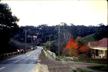
Slide, Fred Harris, Main Street, old river bridge Greensborough, 1949c
... Greensborough crossing the Plenty River via the 'old' bridge.... shows Main Street Greensborough crossing the Plenty River via ...Taken about 1949, this colour slide shows Main Street Greensborough crossing the Plenty River via the 'old' bridge.1 photographic slide in yellow Kodak packet.Name of donor and title of slide written on outside of packetmain street greensborough, plenty river, main street bridge -
 Greensborough Historical Society
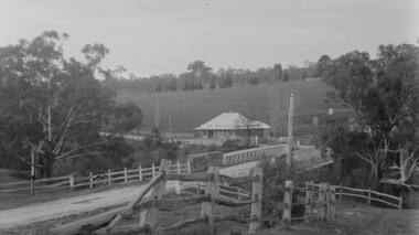
Photograph - Digital Image, Plenty Bridge Hotel, Lower Plenty, 1870s
... of the importance of these river crossings in the mid 19th century lower ...Lower Plenty Hotel. This photograph shows the original Plenty Bridge hotel with Lower Plenty bridge in the foreground. The hotel was built c1858 and the bluestone bridge in the 1860s to replace the earlier toll bridge built in 1858.The close proximity of the hotel to the bridge is an indication of the importance of these river crossings in the mid 19th centuryDigital copy of black and white photographlower plenty, plenty river, plenty bridge hotel, lower plenty bridge, lower plenty hotel -
 Mission to Seafarers Victoria
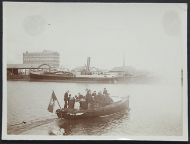
Photograph - Photograph, Sepia, circa 1910
... ", the Mission's motor launch, leaving the Australian Wharf and crossing... launch, leaving the Australian Wharf and crossing the Yarra River ...The motorboat Southern Cross was used for ship visits and also to Bring sailors back to the Mission or picnics.A group of ladies and seamen sitting on the "Southern Cross", the Mission's motor launch, leaving the Australian Wharf and crossing the Yarra River. In the background we can see the "Robur Tea House" warehouse and the south wharf.motor launch, southern cross, yarra river, australian wharf, south wharf, flag, lhlg, robur tea house, missions to seamen, goldsmith album, motorboat, charles blunt, blunt boatbuilders, geelong -
 Mission to Seafarers Victoria
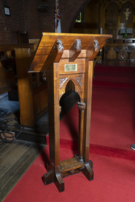
Furniture - Lectern, 1907
The lectern was gifted by Mary Georgina Howard Northcote in December 1907 for the Siddeley Street mission (see Annual Report 1907: list of gifts for the new institute page 8). It was moved to the St Peter Chapel, Flinders Street, and has been in use ever since. Mary nee Reynell in Cheltenham, England, was the wife of Edward Northcote, ex master mariner and general manager of the Adelaide Steamship Company between 1899 and 1926, before his death on 4 November 1926. Edward Northcote was the cousin of Henry Stafford Northcote, Governor General of Australia (1904-1908). Lord Northcote laid the stone of the Siddeley Street Seamen's Institute on Tuesday 5 February 1907. Mary died in December 1932, in her will she made a donation of £25 to the Mission. As it was moved to the St Peter chapel when the Flinders Street Mission opened, it was added to the 1917 list of gifts.The Mission to Seafarers Victoria has been in operation for over 150 years in Victoria although experiencing many name and location changes. Support and patronage by Governors general and State governors was key to official recognition of the work of the Mission.The current site at 717 Flinders Street is the most enduring and many artefacts from previous locations have been relocated to this site. This lectern underscores the relationship between the Mission and notable Victorians.The head of the lectern is supported by three wooden cross sections each engraved with a criss-crossing leaf pattern. The legs of lectern have a similarly carved decorative panel forming an arched shape. Each corner of the panel has gum leafs and nuts carved into it. The foot of the lectern is less ornate although there are three decorated wooden panels mimicking those supporting the head.Brass plaque on lectern: FOR THE GLORY OF GOD/THIS LECTERN/WAS PRESENTED BY/MARY HOWARD NORTHCOTE/DECEMBER 1907religion, lectern, australia-wharf, mary georgina howard northcote nee reynell, edward northcote (1854-1926), adelaide steamship company, henry stafford northcote (1846-1911) g.c.m.g, mission to seafarers, seamen's mission, mission to seamen, flinders street, yarra river, siddeley street, heritage listed, gifts-1917 -
 Greensborough Historical Society
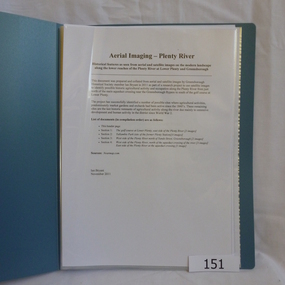
Folder, Aerial Imaging - Plenty River: by Ian Bryant, 2011_11
Investigates early land use along the Plenty River from north of the main aqueduct crossing in Greensborough to south of the golf course in Lower PlentyHistorical features seen from aerial and satellite images of the modern landscape may indicate earlier agricultural land usage.9 x A4 pages of text and colour annotated maps downloaded from nearmap.com.plenty river, ian bryant, lower plenty, greensborough, yallambie park, aerial photography -
 Greensborough Historical Society
Photograph - Digital Image, Pipes over the Plenty River, 1950c
... crossing the Plenty River.... of the Maroondah Aqueduct pipes crossing the Plenty River. maroondah ...An early photograph of the Maroondah Aqueduct pipes crossing the Plenty River.Digital copy of black and white photograph.maroondah aqueduct, plenty river -
 Greensborough Historical Society
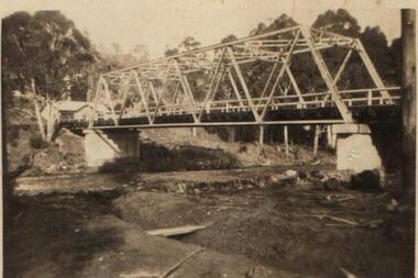
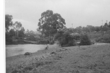
Photograph - Digital Image, Plenty River in flood 1972 Flintoff Street Crossing (2), 1972_
Plenty River in flood, circa 1972. There were two major floods in Greensborough at the time, 1972 and 1974.Digital copy of black and white photograph.plenty river, floods -
 Greensborough Historical Society
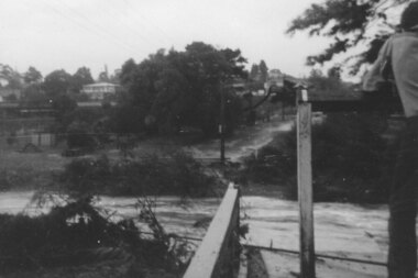
Photograph - Digital image, Plenty River in flood 1972 at Rand Street crossing (3), 1972_
Plenty River in flood Greensborough 1972. There were two major floods in Greensborough at the time, 1972 and 1974. Poulter Reserve was created after the 1972 flood and had to be re-established following the 1974 flood.Digital copy of black and white photograph.plenty river, floods -
 Greensborough Historical Society
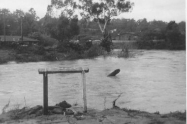
Photograph - Digital Image, Plenty River in flood 1972, view at the Rand Street Crossing, 1972_
Plenty River in flood at the Rand Street Crossing. There were two major floods in Greensborough at the time, 1972 and 1974. Poulter Reserve was created after the 1972 flood and had to be re-established following the 1974 flood.Digital copy of black and white photograph.plenty river, floods -
 Greensborough Historical Society
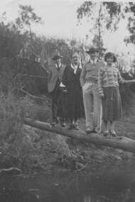
Photograph - Digital image, Alan Partington and others on log to Willis Vale, 1935c
... crossing the Plenty River at Greensborough. This log over the river... from left) and others crossing the Plenty River ...Photograph of Alan Partington (3rd from left) and others crossing the Plenty River at Greensborough. This log over the river was the quickest way to reach the Greensborough township from Willis Vale.A pioneer Greensborough family.Digital copy of black and white photograph.alan partington, willis vale -
 Glenelg Shire Council Cultural Collection
Booklet - Booklet - Nelson and Glenelg River, Victoria, Compiled by N.F. Learmonth, Three Ways to Cross a River, Mar-63
... of Nelson, focussing on the crossings of the Glenelg River - ford... on the crossings of the Glenelg River - ford, punt and bridge. Blue card ...Booklet - 'Three Ways to Cross a River', a short history of Nelson, focussing on the crossings of the Glenelg River - ford, punt and bridge. Blue card, cover, black print. Complied to mark the occasion of the opening of the new Glenelg River bridge at Nelson, 14 Mar 1963 -
 Greensborough Historical Society
Report, Examining Draughtsman's Report - Watts River Aqueduct, 20/07/1897
This Field Survey was commissioned by the Melbourne Board of Works and was used to position the Maroondah Aqueduct bridge north of Greensborough at its crossing point on the Plenty River. It incorporated the use of wrought iron water pipes and therefore is of lighter construction than other similar bridges in the district. It features a traverse of the Plenty RiverThe Maroondah Aqueduct bridge is a significant example of late 19th century engineering. A 4 page reproduction of an Office of Titles document. Copy of handwritten report includes maps.maroondah aqueduct, watts river aqueduct, bridge, greensborough, office of titles, 1897, wrought iron water pipes, plenty river, melbourne board of works -
 Halls Gap & Grampians Historical Society
Postcard - Sepia, C 1931
Knight's Tea House on the Wannon River was run by Gus (Augustus) and Ellen Knight Tea rooms were known as Coonara Tea - House The Knights previously ran a Tea House at the failed Henham estatePost card shows Knight's Tea Rooms at the Wannon CrossingTea Rooms monument will go where this was Post Card correspondence, address only Kodak, Australi buildings, shops, people, knight -
 Eltham District Historical Society Inc
Photograph, Upper Yarra Dam, Spring Tour, 22 Oct 1995, 22/10/1995
EXPLORING THE UPPER YARRA (Newsletter No. 105, November 1995, by Bettina Woodburn) We enjoyed the Spring Excursion, this year "Exploring the Upper Yarra" - in spite of the constant rain and the countryside under the cloud cover, especially in the valleys, being mainly shiny shades of green. The occasional fields of buttercups, clumps of arum lilies and splendid rhododendron and other flowering bushes became very special. The Cobb and Co coach was warm and a cosy retreat as we zig-zagged on the highways and byways to glimpse the Yarra River, upstream and down, its secret places, and particularly the many bridges. Russell excelled as 'Poet Laureate', reading from Dacre Smyth's book. This 1979 publication includes paintings of all the bridges along the river with poems and brief descriptions of each one. Some of the bridges are in out of the way places and are not very well known. We looked forward to hearing the poetry as much as seeing the ' constructions'…Big Pat (was he short or tall, lean or fat? He did win the two hundred pound reward for discovering gold and had the creek named after him), about the 'Eddies'?, and the disliked 'meccano' bridge in Warburton, etc. etc. The hot roast lunch in the old Reefton Hotel was also most welcome. It was easy to imagine it peopled by miners and early settlers. Starting by crossing the new (1974) concrete bridge at Warrandyte we headed through Wonga Park with views to the Christmas Hills and to the escarpment of the Yering Gorge, which causes flood waters to back up through the Yarra Glen plain, so avoiding disasters downstream. At the end of a long driveway we found the wooden, privately owned Henley Bridge (1935 after the 1934 floods). This facilitates access to different parts of Henley Farm and to Lilydale. Everard Park, named after Blanche Shallard's father, a State Member for 17 years, below the Highway Yarra crossing was in need of care. It is 10 miles from Yarra Glen by road but, as "Yarra Marra” canoeists well know, 32 winding miles down by water. After more delightful countryside scenes we joined the Warburton Highway at Woori Yallock. From the old Railway Station at Launching Place the Centennial Trail for walkers, cyclists and ' horse riders has replaced the rails. The line from Lilydale was opened in 1901, and the last diesel freight train ran to Warburton in 1965. It continued to rain as we had morning tea in Warburton in a shelter between footbridges. From here we continued upstream past the Bridge to O'Shannasy Lodge and Reservoir, Starvation Creek, and the Peninsular tunnel (miners dug it as at Pound Bend) which we visited (scrambling down those steps!) on our return after lunch. Our furthermost point was the Upper Yarra Dam Reserve (and vast catchment area). Finished in 1957 after ten years work and 100 years after Yan Yean, it supplies much of Melbourne's water. After crossing the 30m Launching Place Bridge to the Eltham side of the Yarra and Healesville, we saw in the distance the Yarra Glen Timber Trestle Bridge over the river flats "the longest for years in the land it was said!" Harry's dream of "better weather over the Divide" unfortunately didn't come true, but I'm sure we 36 members will retain happy memories of a day that was wet and green and filled with Bridges. Bettina Woodburn - October 1995 Record of the Society's history of activities - Spring 1995 excursionRoll of 35mm colour negative film, 3 stripsKodak Gold 200-4shire of eltham historical society, activities, upper yarra dam, henley bridge -
 Eltham District Historical Society Inc
Photograph, Upper Yarra Dam, Spring Tour, 22 Oct 1995, 22/10/1995
EXPLORING THE UPPER YARRA (Newsletter No. 105, November 1995, by Bettina Woodburn) We enjoyed the Spring Excursion, this year "Exploring the Upper Yarra" - in spite of the constant rain and the countryside under the cloud cover, especially in the valleys, being mainly shiny shades of green. The occasional fields of buttercups, clumps of arum lilies and splendid rhododendron and other flowering bushes became very special. The Cobb and Co coach was warm and a cosy retreat as we zig-zagged on the highways and byways to glimpse the Yarra River, upstream and down, its secret places, and particularly the many bridges. Russell excelled as 'Poet Laureate', reading from Dacre Smyth's book. This 1979 publication includes paintings of all the bridges along the river with poems and brief descriptions of each one. Some of the bridges are in out of the way places and are not very well known. We looked forward to hearing the poetry as much as seeing the ' constructions'…Big Pat (was he short or tall, lean or fat? He did win the two hundred pound reward for discovering gold and had the creek named after him), about the 'Eddies'?, and the disliked 'meccano' bridge in Warburton, etc. etc. The hot roast lunch in the old Reefton Hotel was also most welcome. It was easy to imagine it peopled by miners and early settlers. Starting by crossing the new (1974) concrete bridge at Warrandyte we headed through Wonga Park with views to the Christmas Hills and to the escarpment of the Yering Gorge, which causes flood waters to back up through the Yarra Glen plain, so avoiding disasters downstream. At the end of a long driveway we found the wooden, privately owned Henley Bridge (1935 after the 1934 floods). This facilitates access to different parts of Henley Farm and to Lilydale. Everard Park, named after Blanche Shallard's father, a State Member for 17 years, below the Highway Yarra crossing was in need of care. It is 10 miles from Yarra Glen by road but, as "Yarra Marra” canoeists well know, 32 winding miles down by water. After more delightful countryside scenes we joined the Warburton Highway at Woori Yallock. From the old Railway Station at Launching Place the Centennial Trail for walkers, cyclists and ' horse riders has replaced the rails. The line from Lilydale was opened in 1901, and the last diesel freight train ran to Warburton in 1965. It continued to rain as we had morning tea in Warburton in a shelter between footbridges. From here we continued upstream past the Bridge to O'Shannasy Lodge and Reservoir, Starvation Creek, and the Peninsular tunnel (miners dug it as at Pound Bend) which we visited (scrambling down those steps!) on our return after lunch. Our furthermost point was the Upper Yarra Dam Reserve (and vast catchment area). Finished in 1957 after ten years work and 100 years after Yan Yean, it supplies much of Melbourne's water. After crossing the 30m Launching Place Bridge to the Eltham side of the Yarra and Healesville, we saw in the distance the Yarra Glen Timber Trestle Bridge over the river flats "the longest for years in the land it was said!" Harry's dream of "better weather over the Divide" unfortunately didn't come true, but I'm sure we 36 members will retain happy memories of a day that was wet and green and filled with Bridges. Bettina Woodburn - October 1995 Record of the Society's history of activities - Spring 1995 excursionRoll of 35mm colour negative film, 2 stripsKodak Gold 100-4shire of eltham historical society, activities, upper yarra dam, henley bridge -
 Eltham District Historical Society Inc
Photograph, Upper Yarra Dam, Spring Tour, 22 Oct 1995, 22/10/1995
EXPLORING THE UPPER YARRA (Newsletter No. 105, November 1995, by Bettina Woodburn) We enjoyed the Spring Excursion, this year "Exploring the Upper Yarra" - in spite of the constant rain and the countryside under the cloud cover, especially in the valleys, being mainly shiny shades of green. The occasional fields of buttercups, clumps of arum lilies and splendid rhododendron and other flowering bushes became very special. The Cobb and Co coach was warm and a cosy retreat as we zig-zagged on the highways and byways to glimpse the Yarra River, upstream and down, its secret places, and particularly the many bridges. Russell excelled as 'Poet Laureate', reading from Dacre Smyth's book. This 1979 publication includes paintings of all the bridges along the river with poems and brief descriptions of each one. Some of the bridges are in out of the way places and are not very well known. We looked forward to hearing the poetry as much as seeing the ' constructions'…Big Pat (was he short or tall, lean or fat? He did win the two hundred pound reward for discovering gold and had the creek named after him), about the 'Eddies'?, and the disliked 'meccano' bridge in Warburton, etc. etc. The hot roast lunch in the old Reefton Hotel was also most welcome. It was easy to imagine it peopled by miners and early settlers. Starting by crossing the new (1974) concrete bridge at Warrandyte we headed through Wonga Park with views to the Christmas Hills and to the escarpment of the Yering Gorge, which causes flood waters to back up through the Yarra Glen plain, so avoiding disasters downstream. At the end of a long driveway we found the wooden, privately owned Henley Bridge (1935 after the 1934 floods). This facilitates access to different parts of Henley Farm and to Lilydale. Everard Park, named after Blanche Shallard's father, a State Member for 17 years, below the Highway Yarra crossing was in need of care. It is 10 miles from Yarra Glen by road but, as "Yarra Marra” canoeists well know, 32 winding miles down by water. After more delightful countryside scenes we joined the Warburton Highway at Woori Yallock. From the old Railway Station at Launching Place the Centennial Trail for walkers, cyclists and ' horse riders has replaced the rails. The line from Lilydale was opened in 1901, and the last diesel freight train ran to Warburton in 1965. It continued to rain as we had morning tea in Warburton in a shelter between footbridges. From here we continued upstream past the Bridge to O'Shannasy Lodge and Reservoir, Starvation Creek, and the Peninsular tunnel (miners dug it as at Pound Bend) which we visited (scrambling down those steps!) on our return after lunch. Our furthermost point was the Upper Yarra Dam Reserve (and vast catchment area). Finished in 1957 after ten years work and 100 years after Yan Yean, it supplies much of Melbourne's water. After crossing the 30m Launching Place Bridge to the Eltham side of the Yarra and Healesville, we saw in the distance the Yarra Glen Timber Trestle Bridge over the river flats "the longest for years in the land it was said!" Harry's dream of "better weather over the Divide" unfortunately didn't come true, but I'm sure we 36 members will retain happy memories of a day that was wet and green and filled with Bridges. Bettina Woodburn - October 1995 Record of the Society's history of activities - Spring 1995 excursionRoll of 35mm colour negative film, 4 of 5 stripsKodak Gold 400-5shire of eltham historical society, activities, upper yarra dam, henley bridge -
 Eltham District Historical Society Inc
Photograph, Upper Yarra Dam, Spring Tour, 22 Oct 1995, 22/10/1995
EXPLORING THE UPPER YARRA (Newsletter No. 105, November 1995, by Bettina Woodburn) We enjoyed the Spring Excursion, this year "Exploring the Upper Yarra" - in spite of the constant rain and the countryside under the cloud cover, especially in the valleys, being mainly shiny shades of green. The occasional fields of buttercups, clumps of arum lilies and splendid rhododendron and other flowering bushes became very special. The Cobb and Co coach was warm and a cosy retreat as we zig-zagged on the highways and byways to glimpse the Yarra River, upstream and down, its secret places, and particularly the many bridges. Russell excelled as 'Poet Laureate', reading from Dacre Smyth's book. This 1979 publication includes paintings of all the bridges along the river with poems and brief descriptions of each one. Some of the bridges are in out of the way places and are not very well known. We looked forward to hearing the poetry as much as seeing the ' constructions'…Big Pat (was he short or tall, lean or fat? He did win the two hundred pound reward for discovering gold and had the creek named after him), about the 'Eddies'?, and the disliked 'meccano' bridge in Warburton, etc. etc. The hot roast lunch in the old Reefton Hotel was also most welcome. It was easy to imagine it peopled by miners and early settlers. Starting by crossing the new (1974) concrete bridge at Warrandyte we headed through Wonga Park with views to the Christmas Hills and to the escarpment of the Yering Gorge, which causes flood waters to back up through the Yarra Glen plain, so avoiding disasters downstream. At the end of a long driveway we found the wooden, privately owned Henley Bridge (1935 after the 1934 floods). This facilitates access to different parts of Henley Farm and to Lilydale. Everard Park, named after Blanche Shallard's father, a State Member for 17 years, below the Highway Yarra crossing was in need of care. It is 10 miles from Yarra Glen by road but, as "Yarra Marra” canoeists well know, 32 winding miles down by water. After more delightful countryside scenes we joined the Warburton Highway at Woori Yallock. From the old Railway Station at Launching Place the Centennial Trail for walkers, cyclists and ' horse riders has replaced the rails. The line from Lilydale was opened in 1901, and the last diesel freight train ran to Warburton in 1965. It continued to rain as we had morning tea in Warburton in a shelter between footbridges. From here we continued upstream past the Bridge to O'Shannasy Lodge and Reservoir, Starvation Creek, and the Peninsular tunnel (miners dug it as at Pound Bend) which we visited (scrambling down those steps!) on our return after lunch. Our furthermost point was the Upper Yarra Dam Reserve (and vast catchment area). Finished in 1957 after ten years work and 100 years after Yan Yean, it supplies much of Melbourne's water. After crossing the 30m Launching Place Bridge to the Eltham side of the Yarra and Healesville, we saw in the distance the Yarra Glen Timber Trestle Bridge over the river flats "the longest for years in the land it was said!" Harry's dream of "better weather over the Divide" unfortunately didn't come true, but I'm sure we 36 members will retain happy memories of a day that was wet and green and filled with Bridges. Bettina Woodburn - October 1995 Record of the Society's history of activities - Spring 1995 excursionRoll of 35mm colour negative film, 4 of 5 stripsKodak Gold 400-5shire of eltham historical society, activities, upper yarra dam, henley bridge