Showing 1783 items matching "settlement"
-
 Lakes Entrance Historical Society
Memorabilia, A Pictorial Souvenir Commemorating 150 Years of European Settlement, 2008
Consists of reproductions of various paintings depicting life on Lakes Entrance and Gippsland Lakes, made from heavy cardThe Sesquincentennial Calendar of Lakes Entrance 2008books, periodicals -
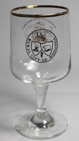 Wodonga & District Historical Society Inc
Memorabilia - Bicentennial Commemorative Wine Glass, Rural City of Wodonga, 1988
A wide range of objects was created throughout Australia to commemorate 200th anniversary of the European settlement of AustraliaThis glass reflects the manner in which the Bicentennial of European settlement in Australia was depicted and commemorated both on a national and local level.A wine glass produced for the Rural City of Wodonga to commemorate the bicentennial of European settlement in AustraliaEmblem of the Rural City of Wodonga On the opposite side image including a sailing ship, an outline of Australia, Above the image "AUSTRALIA'S 200th BIRTHDAY" and below the image "1788-1988"australia, bicentennary, wodonga council -
Lakes Entrance Historical Society
Book, Una Smith, Australia The First Hundred Years, 1976
A facsimile of volumes 1 and 2 of the picturesque atlas of Australia 1888 including short account of Australia as a penal settlement and establishment of separate states Victoriasettlement, exploration, australia -
Port Melbourne Historical & Preservation Society
Card - Member, Dot Wharrie, Port Melbourne Settlement, 1933
(As Settlement was a boy's club, why was Dot WHARRIE, an 8 year old girl, a member?)Port Melbourne Settlement Members Card 1934, belonging to Dot Wharrie.. Blue covers, four page.2d monthly payments entered, February- Aprilsocieties clubs unions and other organisations, dot wharrie, port melbourne settlement -
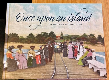 Phillip Island and District Historical Society Inc.
Book, Once upon an Island: the early days of Phillip Island, 2023
Series of articles collected by the Advertiser for the celebration in 2018 of 150 years of European settlement of Phillip Island. Printed by Chicory Publshing, division of The Phillip Island and San Remo .Advertiser.HistoricalColoured hardcover book, 229 pages, with photos, stories and recollections of early settlement of Phillip IslandOnce upon an island : the early days of Phillip Island Collated by Anne Oswin, Eleanor McKAy and Sarah Hudson.phillip island history, phillip island & san remo advertiser, ferries, shipwrecks, motor racing, wollemi, chicory, golden cyprus trees, sharks, guesthouses, army ww1, ww2, warley hospital, football, olive justice, summerland, churchill island, erosion -
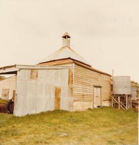 Phillip Island and District Historical Society Inc.
Photograph, 1978/79
Chicory Kiln alongside the house of Mr T Woods in Settlement Road, East Cowes, was built in approx. 1870. It had 18" thick mud brick walls at the core.Photograph of Chicory Kiln on Settlement Road, East Cowes, on land owned by Mr. T. Woods.local history, photographs, buildings - historical, housing, rural industry, coloured photograph, john cook, phillip island, t woods -
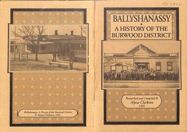 Whitehorse Historical Society Inc.
Booklet - Family History Research paper, Ballyshanassy - A History of the Burwood District, 1991
A comprehensive history of Ballyshanassy and the district of Burwood from rural settlement to busy suburb. The paper was researched and compiled by Alyssa Clarkson in 1991 as part of her VCE studies.A comprehensive history of Ballyshanassy and the district of Burwood from rural settlement to busy suburb. The paper was researched and compiled by Alyssa Clarkson in 1991 as part of her VCE studies. A comprehensive history of Ballyshanassy and the district of Burwood from rural settlement to busy suburb. The paper was researched and compiled by Alyssa Clarkson in 1991 as part of her VCE studies. ballyshanassy, clarkson alyssa, burwood -
 Lakes Entrance Historical Society
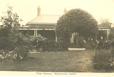
Postcard - Fair Haven, Mallacoota Victoria, 1920 c
Fair Haven was one of the earliest settlements on the Mallacoota lakes, it was run as a guesthouse for some yearsBlack and white postcard of homestead known as Fair Haven situated on the lake at Mallacoota Victoriasettlement, historic buildings -
 St Kilda Historical Society
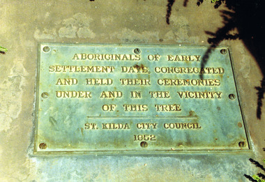
Photograph, Plaque at the Corroboree Tree, Albert Park
Aboriginals of Early Settlement days, congregated and held their ceremonies under and in the vicinity of this tree, St Kilda City Council 1952colour photograph, unmountedAboriginals of early settlement days congregated and held their ceremonies under and in the vicinity of this tree. St Kilda City Council, 1952. -
 Surrey Hills Historical Society Collection
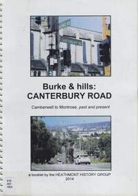
Book, Burke & hills: Canterbury Road, Camberwell to Montrose, past and present, 2014
Co-author Gerry Robinson was a speaker at a Surrey Hills Historical Society (SHHS) meeting. Lyndel Walker, member of SHHS, purchased the book for the collection. This book examines the changing landscape of Canterbury Road from the early days of settlement until today (2015)This book examines the changing landscape of Canterbury Road from the early days of settlement until today (2015)burke, surrey hills, canterbury, broughton park, vegetation, (mr) denis delaney, geology, (mr) john mcclare, geography, (mrs) mary mcclare, churches -
 City of Whittlesea
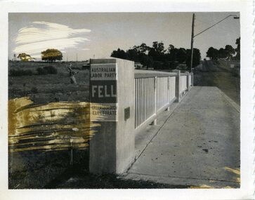
Photograph - Photographs - Bridges, Photograph - Bridge - Bundoora, 1967
Bridge over Darebin Creek, Settlement Road Bundoora. Looking west towards Thomastown, April 1967. Bridge post includes Australian Labor Party election poster for Greensborough Electorate. Bob Fell was the ALP candidate at the 1967 state election which he lost.Photographs, black and white print on paper. Bridge over Darebin Creek, Settlement Road Bundoora 1967. -
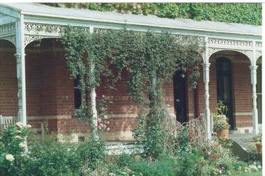 Buninyong & District Historical Society
Photograph - Colour photograph, side veranda "Mt. Boninyong" homestead, Side veranda "Mt. Boninyong" homestead
historic, Scott family, settlement, buildingsColour photo, side veranda "Mt. Boninyong" homestead, partly covered with ivy, climbing roses and jasmine.scott family, settlement, buildings -
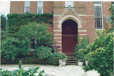 Buninyong & District Historical Society
Photograph - Colour photograph, frint porch "Mt. Boninyong" homestead, Front porch, "Mt. Boninyong" homestead
historic, Scott family, settlement, buildingsColour photo, front porch "Mt. Boninyong" homestead, partly covered with ivy, lush garden.scott family, settlement, buildings -
 Mt Dandenong & District Historical Society Inc.
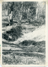
Photograph, Pit Silo 1974 view, 1974
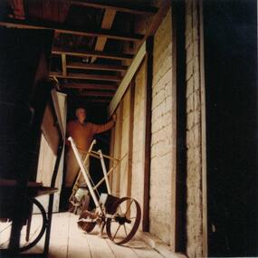
Photograph taken in 1974 showing John Lundy-Clarke standing beside the pit silo he dug in he 1920s on Dunbar's Lot 20 of the Village Settlement. The pit silo was to hold cut maize to turn into silage for a food supply for the cows in the winter.A 1974 view of the pit silo and its maker at Lot 20 of the Village Settlement (Dunbar’s lot) The trees in the background cover the landslide of 1891-1934.pit silo, john lundy-clarke -
 Surrey Hills Historical Society Collection
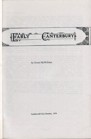
Book, Early Canterbury, 1994
This booklet gives a brief description of the local settlement in Canterbury giving the landholders names and name of the house (before street numbering was introduced) and street it was located in.This booklet gives a brief description of the local settlement in Canterbury giving the landholders names and name of the house (before street numbering was introduced) and street it was located in.canterbury, (ms) jane f portingale, postmistress, (mr) arundel wrighte, wood brothers, koonung creek, (mr) thomas power, (mr) oliver russell, (mr) frederick griffin, (mr) thomas payne, shrublands, w creek, (mr) john gardiner, (mr) james shanley, (mr)robert hoddle, (mr) michael logan, (mr) patrick moloney, (mr) hugh glass, r. larkins, t. hassett, e. sturt, d.s. campbell, (mr) joseph camm, riversdale road, w. logan, rochester road, 1843, trees, mont albert road, a. sikes, (mr) william smith, 1853, (mr) ernest carter, dentist, elgar's surrey, hindson family, (mr) george granville mercy, (mr) alfred golding, (mr)alexander patterson, (mr) thomas boanas, (mr) thomas hyde, builders, (mr) richard terrill, architects, (mr) thomas miles, drapers -
 Surrey Hills Historical Society Collection
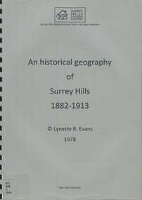
Book, An historical geography of Surrey Hills, 1882-1913, 1979
A thesis submitted for the Degree of Bachelor of Arts with Honours. This thesis presents in a description form, the development of Surrey Hills, an eastern suburb of Melbourne. The settlement and growth from a rural district in 1882 to a suburban centre in 1913.This thesis presents in a description form, the development of Surrey Hills. The settlement and growth from a rural district in 1882 to a suburban centre in 1913.surrey hills, geography, topography, j. knipe, land use, population -
 Marysville & District Historical Society
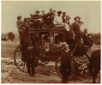
Photograph (item) - Black and white photograph, Nicholas John Caire, 1884
An early black and white photograph taken by Nicholas John Caire in 1884, of a large group of Aborigines on board a Cobb & Co Coach on their way to Coranderrk Aboriginal Settlement.An early black and white photograph taken by Nicholas John Caire in 1884, of a large group of Aborigines on board a Cobb & Co Coach on their way to Coranderrk Aboriginal Settlement.nicholas john caire, cobb & co, coranderrk station, mr john cato, aboriginal station, john green, healesville, badger creek -
Lakes Entrance Historical Society
Book, Morrissey D W and Morrissey E W, Lakes Entrance a Short History and Tourist Guide
A short history of lakes Entrance from early settlement, including references to forest survey, land sales, shipping, fishing industry and development of the town and tourist industry A short history of lakes Entrance from early settlement, including references to forest survey, land sales, shipping, fishing industry and development of the town and tourist industrysettlers, land settlement -
 Mt Dandenong & District Historical Society Inc.
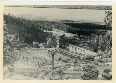
Photograph, Harmony Vale, c1913
View of Harmony Vale, the original Kalorama settlement taken from Barbers Road. Child's sawmill can be seen (centre) with the log yard to the right. Richardson's home "Harmony Vale' is in the orchard above the logs.Black and white photograph copied from a Rose Series postcard showing the area known as "Harmony Vale' - the original Kalorama settlement. Child's sawmill is in the centre.Rose Series Photo of Harmony Vale on the Olinda Creek taken from Logans Lot 28. Link Rd crossing centre Shiloah complex left centre. Richardsons (Jeannie’s) “Mt Calvin” between trees above tree fern. Isaac Jeeves house with the tree fern floor among trees against forest right centre. Mill yard with logs above cultivated flat. Mill to left. “Harmony Vale” homestead among orchard above logs. “Glenrivers” in gully at top of clearing. About 1913. Copied JLC 1973harmony vale, harmony vale, child's sawmill, sawmill, barbers road, richardson, shiloah -
 Surrey Hills Historical Society Collection
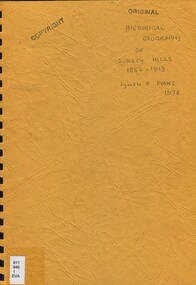
Book, An historical geography of Surrey Hills, 1882-1913, 1979
A thesis submitted for the Degree of Bachelor of Arts with Honours. This thesis presents in a description form, the development of Surrey Hills, an eastern suburb of Melbourne. The settlement and growth from a rural district in 1882 to a suburban centre in 1913.This thesis presents in a description form, the development of Surrey Hills, an eastern suburb of Melbourne. The settlement and growth from a rural district in 1882 to a suburban centre in 1913.surrey hills, geography, topography, j. knipe, land use, population -
 Phillip Island and District Historical Society Inc.
Photograph, 1978/79
View of 18" thick mud brick walls in Chicory Kiln. This was built by Mr T Woods approx. 1870, Settlement Road, East Cowes. Two chicory sowers shown in photograph. Man in photograph is probably Mr T Woods.Photograph of the 18" thick mud brick walls at the core of the old Chicory Kiln on Mr T Woods house, Settlement Road, East Cowes.local history, photographs, buildings - historical, housing, rural industry, coloured photograph, john cook, phillip island, t woods -
 Surrey Hills Historical Society Collection
Book, Wattle Park: a short history, Oct-89
This book includes a description of the early settlement of Wattle Park; who owned the farms prior to it becoming parkland; and the development and management since including the Melbourne and Metropolitan Tramways Board.This book includes a description of the early settlement of Wattle Park; who owned the farms prior to it becoming parkland; and the development and management since including the Melbourne and Metropolitan Tramways Board.wattle park, trees, box trees, golden wattle trees, she-oak trees, (mr) james atkinson, aborigines, first tree, (mr) hector bell, croquet, golf, orienteering, (mr) henry de carle, (mr) john lawler, (mr) walter craig, (mrs) eliza welch, the grange, (miss) effie eliza ball, hawthorn tramways trust, (mr) - membrey, metropolitan tramways park, (mr )david pureau, by-laws, g. t. usher, o. fenwick, f. c. garyder, e, bennet, a. snowden, g. tweedy, (mr) (sir) arthur stanly, (mr)alan holt, (mrs) a bennet, world war, 1939-1945, eucalypts, elm trees, ash trees, (ms) faye shepherd -
Lakes Entrance Historical Society
Book, Adams John, The Tambo Shire Centenary History, 1981
A history of the Shire of Tambo, East Gippsland, Victoria, including many aspects of settlement, development, industries, transport, and the hardy people who tamed this varied and often inhospitable region.A history of the Shire of Tambo, East Gippsland, Victoria, including many aspects of settlement, development, industries, transport, and the hardy people who tamed this varied and often inhospitable region.land settlement, transport -
Lakes Entrance Historical Society
Book - Arthur Phillip, Hughes, Thea Stanley, 1982
An account of the life and achievements of Arthur Phillip, commander of the First Fleet, sent to Botany Bay; the relocation to Port Jackson, and the development of the settlement under his governorship. Written for students.An account of the life and achievements of Arthur Phillip, commander of the First Fleet, sent to Botany Bay; the relocation to Port Jackson, and the development of the settlement under his governorship. Written for students.law, government, land settlement -
 Orbost & District Historical Society
document, Bureau of Meteorology, DROUGHTS IN AUSTRALIA, 1957
Foley, J. C. (James Charles) (1892-1967) , classified major droughts in Australia from the early period of European settlement to 1955 on the basis of rainfall analyses. This document is a useful reference tool.A 19 pp copy of a document titled DROUGHTS IN AUSTRALIA, Review of Records from Earliest Years of Settlement to 1955. It was compiled by the Bureau of Meteorology in September,1957. This section deals mostly with droughts in Victoria.Author J.C. Foleydrought-victoria foley-james-charles bureau-of-meteorology climate -
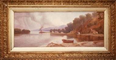 Lakes Entrance Historical Society
Photograph - Maringa Creek, 1997c
Walter Seehusan, first art teacher at Bairnsdale School of Mines. Painting in possession of St Nicholas Anglican Church, Lakes Entrance, Victoria, bequeathed by Miss E L Phillips. Original painting 1890c.Colour photograph of a painting by W Seehusan of view from site of Kalimna Jetty towards Nungurner, showing mill workers cottages, jetty and steamers at Maringa Creek sawmill. Fisherman's cottage in right foreground, settlement at Maringa Creek, Gippsland Lakes, by mill workers and fishermen. Painting shows denuded cliffs and timber slide. Lakes Entrance Victoriawaterways, boats and boating, settlement -
 Orbost & District Historical Society
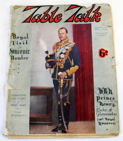
magazine, Table Talk, August 1 1934
This magazine was published as a souvenir to commemorate the centenary of European settlement in Victoria, 1934A 104 page soft covered magazine relating to Melbourne's first 100 years. It contains stories about the settlement of early Melbourne, businesses, land purchases and advertisements. The front cover has a brown background and a colour reproduction of a painting titled Pioneers by W. B. McInnes.tourism recreation history melbourne magazine table-talk -
 Federation University Historical Collection
Photograph, Ballarat 1852
Photograph of a framed oil painting titled 'Ballarat 1852 Tent Settlement from Black Hill. Shows Ballarat Flat, Golden Point township. Black Hill Flat and Sebastopol.ballarat, black hill, golden point, ballarat flat, tents, settlement, black hill flat, sebastopol -
 Port Melbourne Historical & Preservation Society
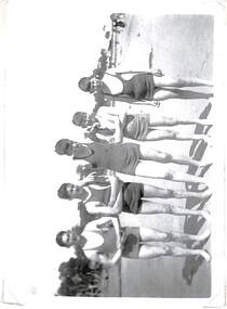
Photograph - Port Melbourne Settlement, beach party, 1930s
Lasercopy of Port Melbourne Settlement photo: five boys at beach party for Settlement, late 1930s?societies clubs unions and other organisations, ken turner, port melbourne settlement -
 Bendigo Historical Society Inc.
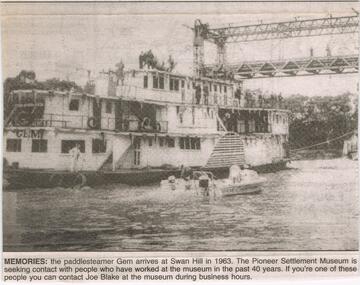
Newspaper - JENNY FOLEY COLLECTION: MEMORIES
The paddle steamer "Gem was first launched in 1876 as a passenger and cargo mode of transport on the Murray River. In the '30's and '40's it operated as a tourist passenger boat. In 1948 it sunk in 15 feet of water but was repaired and refloated. It was retired in 1950. In 1962 it was sold to the Swan Hill pioneer Settlement. The Swan Hill Folk Museum was Australia's first open air museum and opened to the public in 1966, It was renamed the Pioneer Settlement.Bendigo Advertiser ''The way we were'' from 2003. Memories: the paddle steamer Gem arrives at Swan Hill in 1963. the pioneer Settlement Museum is seeking contact with people who have worked at the museum in the past 40 years. The clip is in a folder.newspaper, bendigo advertiser, the way we were