Showing 797 items matching "shire avenue"
-
 Phillip Island and District Historical Society Inc.
Photograph, 1960
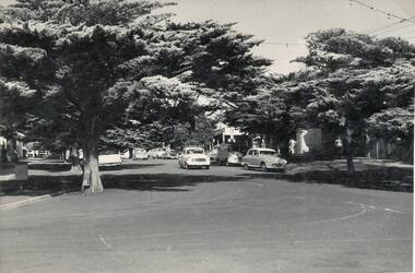
One of a collection of over 400 photographs in an album commenced in 1960 and presented to the Phillip Island & Westernport Historical Society by the Shire of Phillip IslandPhotograph taken in 1960 and looking south along Thompson Avenue, Cowes.local history, photography, thompson avenue, cowes, black & white photograph, thompson avenue cowes, john jenner, bryant west -
 Phillip Island and District Historical Society Inc.
Photograph
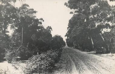
One of a collection of over 400 photographs in an album commenced in 1960 and presented to the Phillip Island & Westernport Historical Society by the Shire of Phillip IslandPhotograph looking north along the old Main Road now Thompson Avenuelocal history, photography, thompson avenue, black & white photograph, thompson avenue cowes, phillip island, john jenner, bryant west -
 Phillip Island and District Historical Society Inc.
Photograph, 1900
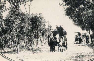
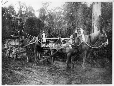
One of a collection of over 400 photographs in an album commenced in 1960 and presented to the Phillip Island & Westernport Historical Society by the Shire of Phillip IslandCopy of a Postcard of Horse Drawn Lorries carting wool along Thompson Avenue in the early 1900'slocal history, photography, wool carting, black & white photograph, horse transport, wool industry, thompson avenue cowes, john jenner, bryant west -
 Phillip Island and District Historical Society Inc.
Photograph
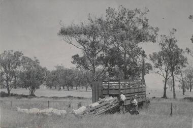
One of a collection of over 400 photographs in an album commenced in 1960 and presented to the Phillip Island & Westernport Historical Society by the Shire of Phillip IslandPhotograph of Sheep from Swan Hill being unloaded from at "Byfrons", Thompson Avenue, Cowes.local history, photography, sheep unloading, black & white photograph, rural industry, sheep, "byfrons", john jenner, bryant west -
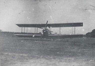 Phillip Island and District Historical Society Inc.
Photograph, 1920
One of a collection of over 400 photographs in an album commenced in 1960 and presented to the Phillip Island & Westernport Historical Society by the Shire of Phillip IslandPhotograph of an early Bi Plane landing on the site of the Main Garage, Thompson Avenue, Cowes - 1920local history, photography, aeroplane, black & white photograph, air transport, bi planes, john jenner, bryant west -
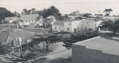 Phillip Island and District Historical Society Inc.
Photograph, c. 1959
One of a collection of over 400 photographs in an album commenced in 1960 and presented to the Phillip Island & Westernport Historical Society by the Shire of Phillip IslandAerial photograph of the intersection of Thompson Avenue & Chapel Street showing General Store, Phillip Island Garage and Catholic Church.local history, photography, intersection thompson avenue & chapel street, cowes, black & white photograph, thompson avenue cowes, chapel street cowes, garages, churches, john jenner, bryant west -
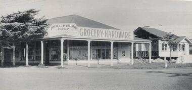 Phillip Island and District Historical Society Inc.
Photograph, 1959
One of a collection of over 400 photographs in an album commenced in 1960 and presented to the Phillip Island & Westernport Historical Society by the Shire of Phillip IslandPhotograph of corner Grocery & Hardware Shop, Thompson Avenue & Chapel Street intersection. 1959local history, photography, phillip island co-op store, black & white photograph, shops, thompson avenue cowes, old store, john jenner, bryant west -
 Greensborough Historical Society
Map, Melbourne and Metropolitan Board of Works. Survey Division, MMBW, Yarra 2500 / 12.20. Watsonia Railway Station and environs, 1983_03
Melbourne and Metropolitan Board of Works. Yarra 2500 [base map]. 12-20, Parishes of Keelbundora 2856, Municipalities of Diamond Valley 257 and 228. Shows street names, easement sizes, lot numbers, lodged plan numbers, names of prominent features, contour values, creek or river names. Watsonia Railway Station and environs. Prominent streets: Watsonia Road, Elder Street, Morwell Avenue and Nepean Street. Includes former Watsonia Technical School and Gresswell Rehabilitation Centre sites.MMBW Map in 1:2500 [scale] series. Cream parchment with green tape reinforcing on edges and punched holes on left edge.mmbw, melbourne and metropolitan board of works, shire of diamond valley, watsonia - maps -
 Greensborough Historical Society
Map, Melbourne and Metropolitan Board of Works. Survey Division, MMBW, Yarra 2500 / 17.26. Hurstbridge, 1978_01
Melbourne and Metropolitan Board of Works. Yarra 2500 [base map] 17-26. Hurstbridge. Municipalities of Diamond Valley 257 and Eltham 238. Prominent streets include: Flat Rock Road and Heather Avenue. Includes Hurstbridge Railway Station.MMBW Map in 1:2500 [scale] series. Cream parchment with green tape reinforcing on edges and punched holes on left edge.mmbw, melbourne and metropolitan board of works, shire of diamond valley, hurstbridge - maps -
 Greensborough Historical Society
Map, Melbourne and Metropolitan Board of Works. Survey Division, MMBW, Yarra 2500 / 17.27. Central Hurstbridge, 1978_02
Melbourne and Metropolitan Board of Works. Yarra 2500 [base map] 17-27. Central Hurstbridge. Parish of Greensborough 2724, Municipalities of Diamond Valley 257, Eltham 238 and Whittlesea 239. Prominent streets include: Anzac Avenue and Hurstbridge-Arthurs Creek Road. MMBW Map in 1:2500 [scale] series. Cream parchment with green tape reinforcing on edges and punched holes on left edge.mmbw, melbourne and metropolitan board of works, shire of diamond valley, hurstbridge - maps -
 Greensborough Historical Society
Map, Melbourne and Metropolitan Board of Works. Survey Division, MMBW, Yarra 2500 / 16.23. Diamond Creek, 1978_02
Melbourne and Metropolitan Board of Works. Yarra 2500 [base map] 16-23. Diamond Creek. Parish of Nillumbik 3310. Municipalities of Diamond Valley 257 and Eltham 238. Prominent streets include: Phipps Crescent, Bishop Avenue, and Reynolds Road. Includes the former Diamond Creek Technical School.MMBW Map in 1:2500 [scale] series. Cream parchment with green tape reinforcing on edges and punched holes on left edge.mmbw, melbourne and metropolitan board of works, shire of diamond valley, diamond creek - maps -
 Greensborough Historical Society
Photograph, Vacant land, Corner Wilson Avenue and Rattray Road Montmorency 1985, 1985_
A photograph of vacant land, Corner Wilson Avenue and Rattray Road Montmorency 1985, taken by Peter Graham, a Shire of Eltham Councillor.1 colour photograph.montmorency, peter graham, rattray road montmorency, wilson avenue montmorency -
 Greensborough Historical Society
Map, Melbourne and Metropolitan Board of Works. Survey Division, MMBW, Yarra 2500 / 15.28. Yarrambat, 1977_10
Melbourne and Metropolitan Board of Works. Yarra 2500 [base map] 15-28. Yarrambat. Municipalities of Diamond Valley 257 and Whittlesea 239. Prominent streets include: Edward Henty Avenue, Charles Sturt Drive and Creighton Way. MMBW Map in 1:2500 [scale] series. Cream parchment with green tape reinforcing on edges and punched holes on left edge.mmbw, melbourne and metropolitan board of works, shire of diamond valley, yarrambat - maps -
 Greensborough Historical Society
Map, Melbourne and Metropolitan Board of Works. Survey Division, MMBW, Yarra 2500 / 16.27. Hurstbridge, 1977_10
Melbourne and Metropolitan Board of Works. Yarra 2500 [base map] 16.27. Hurstbridge. Parish of Greensborough 2724. Municipalities of Whittlesea 239 and Diamond Valley 257. Prominent streets include: Haleys Gully Road, Kendalls Lane and Bingley Avenue. MMBW Map in 1:2500 [scale] series. Cream parchment with green tape reinforcing on edges and punched holes on left edge.mmbw, melbourne and metropolitan board of works, shire of diamond valley, shire of whittlesea, hurstbridge - maps -
 Greensborough Historical Society
Map, Melbourne and Metropolitan Board of Works. Survey Division, MMBW, Yarra 2500 / 13.24. Plenty, Memorial Drive, 1979_03
Melbourne and Metropolitan Board of Works. Yarra 2500 [base map] 13-24. Plenty, Memorial Drive. Parish of Morang 3183. Municipalities of Diamond Valley 257 and Whittlesea 239. Prominent streets include: Oatland Road, River Avenue and Memorial Drive. Includes Plenty River and SEC Transmission easement.MMBW Map in 1:2500 [scale] series. Cream parchment with green tape reinforcing on edges and punched holes on left edge.mmbw, melbourne and metropolitan board of works, shire of diamond valley, plenty - maps -
 Greensborough Historical Society
Map, Melbourne and Metropolitan Board of Works. Survey Division, MMBW, Yarra 2500 / 14.20. Montmorency, Sherbourne Road, 1977_06
Melbourne and Metropolitan Board of Works. Yarra 2500 [base map] 14.20. Montmorency, Sherbourne Road. Municipality of Diamond Valley 257 and Eltham 238. Prominent streets: Sherbourne Road, Karingal Drive and Calrossie Avenue. Features include Montmorency Station and Meruka Park.MMBW Map in 1:2500 [scale] series. Cream parchment with green tape reinforcing on edges and punched holes on left edge.mmbw, melbourne and metropolitan board of works, shire of diamond valley, montmorency - maps -
 Greensborough Historical Society
Photograph, Unknown, Studleys of Scotland Avenue, 1920c
G.H. Studley [probably] and two children at 11 Scotland Avenue Greensborough. G. H. Studley was the son of Mr. G. Studley [it is supposed] who was Shire President of Heidelberg and prominent citizen in the 1860-1880s. Studley Road in Heidelberg is named after him.Copy of Black and white photograph in mount.studley, scotland avenue -
 Greensborough Historical Society
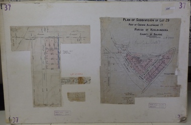
Planning Document, Subdivision Plan # 37. Poulter Avenue and Bicton Street; and, Adeline Street and Grimshaw Street Greensborough, 1971_
Plan of subdivision Lot 29, Part of Crown Allotment, Parish of Keelbundoora, County of Bourke. Poulter Avenue and Bicton Street; and, Adeline Street and Grimshaw Street.An example of hard copy subdivision plans from the Greensborough area. Mainly from the Shire of Diamond Valley era (1964-1994).Plan (2 sheets) mounted on heavy card. subdivision plans, grimshaw street, poulter avenue, adeline street -
 Greensborough Historical Society
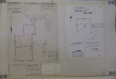
Planning Document, Subdivision Plan #1041. Elder Street Greensborough, 20/04/1983
Plan of Consolidation of Allotments 3 and 4 Brixton Avenue and Plan of Subdivision for Elder Street. An example of hard copy subdivision plans from the Greensborough area. Mainly from the Shire of Diamond Valley era (1964-1994).Plan (2 sheets) mounted on heavy card.Stamped and handwritten Council permissions, dates and other details.subdivision plans, elder street, brixton avenue -
 Glenelg Shire Council Cultural Collection
Slide - Slide - Glass Plate Negative Queens Avenue Portland, 1890-1910
Glass plate negative. 'Queens Avenue' - Percy Street looking north from the Julia Street corner. -
 Eltham District Historical Society Inc
Photograph, Parking Avenue, The Mountain Trail, Kinglake
Source: Mrs. McMinn, KinglakeThis photo forms part of a collection of photographs gathered by the Shire of Eltham for their centenary project book,"Pioneers and Painters: 100 years of the Shire of Eltham" by Alan Marshall (1971). The collection of over 500 images is held in partnership between Eltham District Historical Society and Yarra Plenty Regional Library (Eltham Library) and is now formally known as the 'The Shire of Eltham Pioneers Photograph Collection.' It is significant in being the first community sourced collection representing the places and people of the Shire's first one hundred years.Digital imagesepp, shire of eltham pioneers photograph collection, kinglake, mountain trail, parking avenue -
 Eltham District Historical Society Inc
Photograph, Shire of Eltham, Montmorency - Calrossie Avenue (newly constructed road and footpaths), November 1966
New paved road, footpaths and gutters on Calrossie Avenue, Montmorency.This photo forms part of a collection of photographs gathered by the Shire of Eltham for their centenary project book, "Pioneers and Painters: 100 years of the Shire of Eltham" by Alan Marshall (1971). The collection of over 500 images is held in partnership between Eltham District Historical Society and Yarra Plenty Regional Library (Eltham Library) and is now formally known as 'The Shire of Eltham Pioneers Photograph Collection.' It is significant in being the first community sourced collection representing the places and people of the Shire's first one hundred years.Digital imagesepp, shire of eltham pioneers photograph collection, montmorency, calrossie avenue, road construction, footpaths -
 Eltham District Historical Society Inc
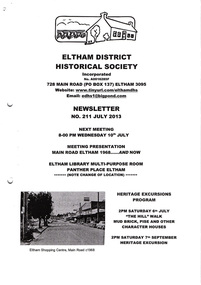
Newsletter, Newsletter, No. 211 July 2013
Contents: • Next meeting, Presentation: Main Road Eltham 1968…..And Now • July Meeting • July Excursion – Mud Bricks, Pise and Other ‘Character Houses’ • Nillumbik Reconciliation Plaques • A Busy Time for Enquiries, Donations and Other Things • Mac Ball • Former Hat Factory • Avenue of Honour • And Also The Shire of Eltham Historical Society was formed in October 1967. The first newsletter of the Society was issued May 1978 and has been published continuously ever since on a bi-monthly basis. With the cessation of the Shire of Eltham in late 1994, the Society's name was revised to Eltham District Historical Society and this name first appeared with issue No. 103, July 1995. The collection of the Society's newsletters provides a valuable resource on the history of the Society's activities, office bearers and committee members, guest speakers and subjects of historical interest pertinent to the former Shire of Eltham and the Eltham District.A4 photocopied newsletter distributed to membersnewsletter, eltham district historical society, shire of eltham historical society -
 Eltham District Historical Society Inc
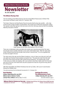
Newsletter, Newsletter, No. 223 July 2015
Contents: • The Eltham Racing Club • July Meeting • July Excursion - Montmorency - the farm on the Plenty • Building and Completion of Saint Margaret's Church 1860-2014 by Geoff Sandy • Miss Bessie Wingrove - that Queer Creature Called a Land Lover by Maureen Jones • Eltham Avenue of Honour - Launch of New Markers by Jim Connor • Membership Subscriptions • ....and also • Contacts for the Eltham District Historical Society The Shire of Eltham Historical Society was formed in October 1967. The first newsletter of the Society was issued May 1978 and has been published continuously ever since on a bi-monthly basis. With the cessation of the Shire of Eltham in late 1994, the Society's name was revised to Eltham District Historical Society and this name first appeared with issue No. 103, July 1995. The collection of the Society's newsletters provides a valuable resource on the history of the Society's activities, office bearers and committee members, guest speakers and subjects of historical interest pertinent to the former Shire of Eltham and the Eltham District.A4 photocopied newsletter distributed to membersnewsletter, eltham district historical society, shire of eltham historical society -
Eltham District Historical Society Inc
Newspaper - Newsclipping, Nillumbik Mail, "A Memorial Avenue of Honour", A Journey in Time: A column about Nillumbik's history, Nillumbik Mail, 24 May 2000, p4, 2000
Main Road, Eltham, south from Brougham Street to Dalton Street, c.1911 View looking down Policeman’s Hill on Maria Street (Main Road) from near Brougham Street towards Dalton Street, site of the Avenue of Honour established in 1916-1917 in memory of the soldiers who served in the First World War, 1914-1918. At the bottom of the hill on the right is White Cloud Cottage, home of the Jarrold family, three women standing out front observing the photographer. The road passes over a culvert which runs to the west in front of the cottage. The cottage was originally located closer to the Diamond Creek but was subject to flooding. It was dragged by horse to the present site shown, which was chosen for the higher ground that had been created as a result of land fill being deposited here from the quarry further around the bend on Main Road (site of present-day Eltham Primary School carpark) where the stone had been quarried for building the State School in Dalton Street. Immediately at the end of the straight section of the main road can be seen the gas streetlamp in front of the Jarrold home and the pond at the bottom of Dalton Street. The cottage had previously been rented for use as a Police Station / residence prior to the building of the permanent police house and station at the corner of Maria and Brougham streets in 1859. At the time of collection of photos for the centenary of the Shire of Eltham (1971) the cottage was owned by the Skipper family and remains in the family to present day (2021). On the left is the Grant house on the corner of Main Road and Dalton Street now the present-day site of Eltham Clinic. Photographer: J.H. Clark John Henry Clark was the youngest of three boys born to William Henry Clark (1823-1877) and Maria White (1843-1914). He and his brothers, William Charles Clark (1872-1945), Clement Kent Clark (1874-1912) operated a photography business (Clark Bros.) from 25 Thomas Street, Windsor near Prahran during the period c.1894 to 1914. Following death of Clement in September 1912 and their mother in 1914, the Clark Bros business appears to have dissolved, the premises demolished, and a new house was under construction in 1915. John set up business independently in 1914 operating out of 29 Moor Street, Fitzroy where he is registered in the 1914 and 1915 Electoral Rolls. By 1916 John had relocated to Eltham where he continued his practice as a photographer and took many of the early images around the district of Little Eltham. Around 1930 John changed professions and opened a small cobbler's shop in 1931 near the pond opposite Dalton Street adjacent to the Jarrold family cottage. He never married and continued his profession as a bootmaker from this little shop, maintaining a close relationship with Mrs Jarrold for the rest of their lives. His bootmaker shop remains today beside the Whitecloud cottage and is one of only three remaining shops in the area from the early 20th century. There are a couple of images of Eltham taken by Clark Bros. in the Eltham District Historical Society collection, one such example being Hunniford’s Post Office with Miss Anne Hunniford out front (EDHS_00140 - marked on the back of the print, Clark Bros., 25 Thomas St. Windsor), which would date this image between c.1894 and 1914. Other early images of Eltham taken by John Henry Clark are marked on the face “J. H. Clark Photo” and it is assumed these are dated between 1914 and 1930. It is noted that the Grant of Probate for John H Clark of Eltham South dated 5 April !957 (513/387) records his occupation as "X Photographer".Newsprint pageNillumbik Mail publication details; Edition 4, 24 May 2000, p4dalton street, avenue of honour, eltham clinic, gas lamp, grant house, j.h. clark photo, jarrold cottage, jarrold family, main road, shire of eltham pioneers photograph collection, white cloud cottage -
 Eltham District Historical Society Inc
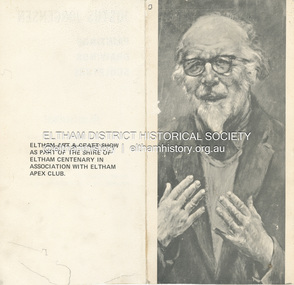
Folder, Jorgensen, Justus
1. Exhibition Invitation: Justus Jorgensen; Paintings, Drawings, Sculpture, A Retrosepctive Exhibition, to be opened by Professor W. MacMahon Ball, Montsalvat, Hillcrtest Avenue, Eltham , Saturday 3rd April (1971) at 11.00 a.m.. (Eltham Art and Craft show as part of the Shire of Eltham Centenary in association with Eltham Apex Club). 2. Mini Biography: Justus Jorgensen (1894-1975) 3. An ode to the trendies, John March, The Age, Saturday, August 12, 1978, p15 - a review of a visit to Montsalvat and poetry reading during the 1978 Eltham Fesitval. Includes picture of Justus Jorgensen and cartoon sketch by Harper (?) 4. Mini Biography: Justus JorgensenFolder of information on Justus Jorgensen, artist and architect, Montsalvat.justus jorgensen, artist, eltham apex club, eltham art & craft show, exhibition, invitation, montsalvat, shire of eltham centenary, william macmahon ball, biography, 1978, david campbell, dorothy hewett, eltham festival, frank kellaway, poetry reading, poets, rosemary dobson, eltham cemetery, lily jorgensen -
 Eltham District Historical Society Inc
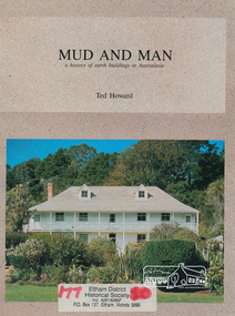
Book, Earthbuild, Mud and Man: a history of earth buildings in Australia by Ted Howard, 1992
Includes references to local sites Bear's Castle, Yan Yean (City of Whitlesea), mud brick houses in Eltham, including at Montsalvat and Eltham Community Centre, Smith's Gully, Plenty Baptist Church and Warrandyte. Includes chapter on Alistair Knox. The author's own home appears in the book on page 100. It was situated at Batman Road, Eltham next to the manse and church opposite Stanley Avenue. It was demolished for unit development June 2004 after the author's death in 2003. A significant and oft cited history of the mud brick earth construction style of architecture which includes a number of examples within the Shire of Nillumbik, known to be a site of the environmental earth building movement following WW2.198 p. : ill. (some col.), maps ISBN 0646069624earth construction, mud bricks, pise, domestic architecture -
 Emerald Museum & Nobelius Heritage Park
Mounted Photograph, 25/4/1921
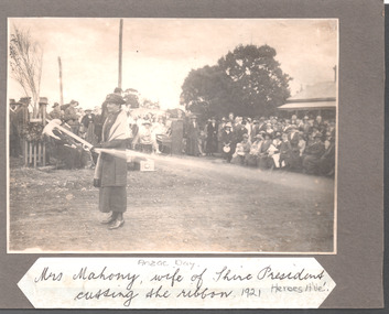
The object is historically and socially significant as it shows the opening of Heroes Avenue (Avenue of Honor) three years after the end of Word War I. The trees planted in the Avenue came from the Nobelius Nursery.Photograph mounted on card of the opening of Heroes Avenue, Emerald on ANZAC Day 1921. Showing Mrs Mahony cutting the ribbon.Mrs Mahony, wife of Shire President, cutting the ribbon. ANZAC Day 1921 Heroes Aveanzac, heroes avenue, avenue of honor, emerald -
 Emerald Museum & Nobelius Heritage Park
Mounted Photograph, 25/4/1921
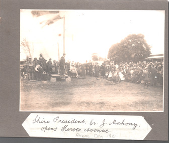
... . anzac heroes avenue avenue of honor emerald Shire President Cr J ...The object is historically and socially significant as it shows the opening of Heroes Avenue (Avenue of Honor) three years after the end of Word War I. The trees planted in the Avenue came from the Nobelius Nursery.Photograph mounted on card of the opening of Heroes Avenue, Emerald on ANZAC Day 1921. Showing Shire President Cr J Mahony opening the AvenueShire President Cr J Mahony, opens Heroes Avenue. ANZAC Day 1921anzac, heroes avenue, avenue of honor, emerald -
 Eltham District Historical Society Inc
Photograph, W.G. Gray with trees from Kinglake, 1918c
W.G (William George) Gray, owner of Allwood Nurseries in Hurstbridge, with horses and cart laden with trees from Kinglake from where he also had a property raising stock. Shire of Eltham Councillor Gray donated English oak and oriental trees for the Anzac avenue at Hurstbridge planted in 1918. In 1922 he operated a well cultivated property of 64 cleared acres, 56 of which were under nursery healthy stock, principally apples, peaches, plums and cherries. In addition to 4 acres of potatoes. This photo forms part of a collection of photographs gathered by the Shire of Eltham for their centenary project book, "Pioneers and Painters: 100 years of the Shire of Eltham" by Alan Marshall (1971). The collection of over 500 images is held in partnership between Eltham District Historical Society and Yarra Plenty Regional Library (Eltham Library) and is now formally known as 'The Shire of Eltham Pioneers Photograph Collection.' It is significant in being the first community sourced collection representing the places and people of the Shire's first one hundred years.Digital imagesepp, shire of eltham pioneers photograph collection, hurstbridge, william george gray, kinglake, horse-drawn vehicle, trees