Showing 577 items matching "shire of diamond valley"
-
 Greensborough Historical Society
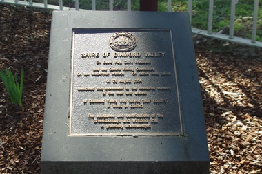
Photograph - Digital image, Marilyn Smith, Shire of Diamond Plaque, Greensborough War Memorial Park, 1994, 26/08/1994
... shire of diamond valley...This photograph shows the Shire of Diamond Valley plaque....' The Shire of Diamond Valley was a local government area from 1964 ...This photograph shows the Shire of Diamond Valley plaque in War Memorial Park Greensborough. The monument is 'dedicated to the honoured memory of the men and women of Diamond Valley who served their country in times of conflict.' The Shire of Diamond Valley was a local government area from 1964 to 1994.Digital copy of colour photograph.greensborough war memorial park, shire of diamond valley -
 Greensborough Historical Society
Memoir, The larrikin pig / by Nancy Fowkes (nee O'Neill), 1968-1975
... shire of diamond valley... of Diamond Valley.... a story of the Shire of Diamond Valley. A personal story of life ...Nancy Fowkes (nee O'Neill) relates a story of the Shire of Diamond Valley.A personal story of life in Greensborough.1 page text.shire of diamond valley -
 Greensborough Historical Society
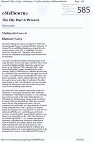
Article, Diamond Valley (eMelbourne), 1836o
... shire of diamond valley...A short history of the Diamond Valley and Shire of Diamond... Valley and Shire of Diamond Valley from the website ...A short history of the Diamond Valley and Shire of Diamond Valley from the website www.emelbourne.net.au 2 pages downloaded from eMelbourne site on 1/4/2012.shire of diamond valley, greensborough, diamond valley -
 Greensborough Historical Society
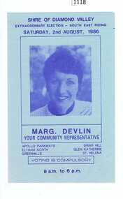
Leaflet, Margaret Devlin, Political advertisement for Margaret Devlin, 02/08/1986
... shire of diamond valley... in the Shire of Diamond Valley.... South East Riding election in the Shire of Diamond Valley ...Advertising leaflet for the 1986 South East Riding election in the Shire of Diamond Valley.One page, blue paper and black print.margaret devlin, shire of diamond valley -
 Greensborough Historical Society
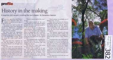
Newspaper clipping, Diamond Valley Leader, History In The Making, 2009_
... shire of diamond valley... Withers with the Shire of Diamond Valley.... of GHS President Noel Withers with the Shire of Diamond Valley ...Records the employment history of GHS President Noel Withers with the Shire of Diamond Valley.Highlights that residents' concerns from 40 years ago are similar to concerns in the current era.A Diamond Valley Leader article on the retirement of Noel Withers, written by Genevieve Gannon.Nilshire of diamond valley, noel withers, greensborough plaza, greensborough swimming pool -
 Greensborough Historical Society
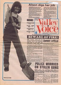
Newspaper, The Valley Voice, The Valley Voice, No. 28, 10 January 1979, 10/01/1979
... shire of diamond valley.... Contains local news in the Shire of Diamond Valley.... Valley. shire of diamond valley 16 p. black & white & colour ...Complete copy of The Valley Voice, 10 January 1979. Contains local news in the Shire of Diamond Valley.16 p. black & white & colour. shire of diamond valley -
 Greensborough Historical Society
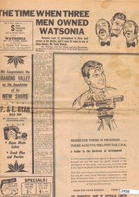
Newspaper Clipping, Diamond Valley News, The Time when three men owned Watsonia; St Katherine's Church at St Helena; When the railway came to the Diamond Valley, 29/09/1964
... shire of diamond valley... in the new Shire of Diamond Valley - Greensborough, Watsonia and St... on the history of suburbs in the new Shire of Diamond Valley ...Three articles from 1964 on the history of suburbs in the new Shire of Diamond Valley - Greensborough, Watsonia and St Helena.Articles on the building of Greensborough, Montmorency and Watsonia Railway Stations, and establishment of St Helena.Pp. 28-30 of Diamond Valley News, 29 September 1964.greensborough railway station, montmorency railway station, watsonia, watsonia railway station, beale family, frank watson, shire of diamond valley, st helena -
 Greensborough Historical Society
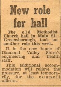
Newspaper Clipping - Digital Image, New role for hall, 28/11/1967
... shire of diamond valley... by the Shire of Diamond Valley for its Engineering and Health staff... in Main Street was used by the Shire of Diamond Valley for its ...The old Methodist Church Hall in Main Street was used by the Shire of Diamond Valley for its Engineering and Health staff in 1967.Digital copy of newspaper clipping.methodist church greensborough, shire of diamond valley -
 Greensborough Historical Society
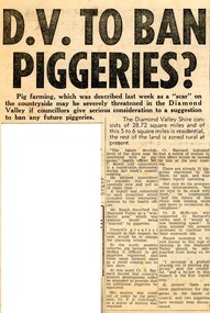
Newspaper Clipping - Digital Image, D.V. to ban piggeries? 1966, 19/07/1966
... shire of diamond valley...In 1966, approximately 25% of the Shire of Diamond Valley...% of the Shire of Diamond Valley was zoned rural. There were up to 25 ...In 1966, approximately 25% of the Shire of Diamond Valley was zoned rural. There were up to 25 piggeries operating in the Shire. In this article, councillors are considering phasing out piggeries by proposing a change to by-laws.An article about changes of the area from rural to residential in the time of Shire of Diamond Valley.News clipping, black and white text.shire of diamond valley, piggeries, pig farms -
 Greensborough Historical Society
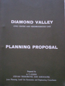
Document - Planning Document, Diamond Valley Civic Centre and Neighbourhood Unit: Planning Proposal, 1960s
... shire of diamond valley... for a Civic Centre in the (then) Shire of Diamond Valley. The plans... for a Civic Centre in the (then) Shire of Diamond Valley. The plans ...This document proposes the change of land use from farming and quarrying to residential. This also includes the proposal for a Civic Centre in the (then) Shire of Diamond Valley. The plans listed in the 'Schedule of Plans' on last page are missing.Includes proposal for the Aqueduct to be converted to an underground system. Includes statistics relating to population increase. Dark brown plastic folder. 23 foolscap-size pages. Maps, Application for Permits to subdivide land in the Greensborough area.partington family, mitchell family, whittingham family, albion reid, diamond valley civic centre, shire of diamond valley -
 Greensborough Historical Society
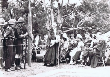
Photograph, Cr Jessop opens a venue in Diamond Creek
... shire of diamond valley... in the Diamond Valley Story, published by the Shire of Diamond Valley... by the Shire of Diamond Valley in 1979. diamond creek cecil jessop ...This undated photograph shows Councillor Cecil Jessop, as Mayor of Heidelberg, opening a venue in Diamond Creek, possibly a pool. Photographed b G. Cox, this photograph appeared in the Diamond Valley Story, published by the Shire of Diamond Valley in 1979.Large black and white photograph of a group of people at an official event.diamond creek, cecil jessop, shire of diamond valley -
![Photograph - Digital image, Civic Centre [Greensborough], 02/05/2013](/media/collectors/4f729f5697f83e03086015b8/items/5729b7242162f108e8de0add/item-media/5729b7552162f108e8de1585/item-fit-380x285.jpg) Greensborough Historical Society
Greensborough Historical SocietyPhotograph - Digital image, Civic Centre [Greensborough], 02/05/2013
... shire of diamond valley... of the Shire of Diamond Valley but is now the offices of the Shire... Centre was originally the offices of the Shire of Diamond Valley ...These three photographs of the Civic Centre precinct, including the Diamond Valley Library; were taken in 2013 to show changes over 40 years; based on Ron Reynold’s sketches in the 1973 publication 'Greensborough and Greenhills' published by Cypress Books. Built in the 1970s, the Civic Centre was originally the offices of the Shire of Diamond Valley but is now the offices of the Shire of Nillumbik.Digital copy of 3 colour photographs.greensborough and greenhills, shire of diamond valley, shire of nillumbik, ron reynolds -
 Eltham District Historical Society Inc
Photograph, Book launch "Pioneers & Painters", 7 Jul 1971
... Shire of Diamond Valley... of Greensborough. Fell was a founding councillor for the Shire of Diamond... of Parliament Councilors Shire of Diamond Valley Greeting municipal ...Launch of "Pioneers and Painters: One Hundred years of Eltham and its Shire" by Alan Marshall. The history was commissioned by the Shire of Eltham and published as part of the Shire of Eltham centenary celebrations. Cr. G.C. Dreverman, Cr. A.F.C. Glover and Mr Robert W. Fell, M.L.A. for the electorate of Greensborough. Fell was a founding councillor for the Shire of Diamond Valley in 1964. He served as M.L.A. 1970-1973. This photo forms part of a collection of photographs gathered by the Shire of Eltham for their centenary project book, "Pioneers and Painters: 100 years of the Shire of Eltham" by Alan Marshall (1971). The collection of over 500 images is held in partnership between Eltham District Historical Society and Yarra Plenty Regional Library (Eltham Library) and is now formally known as 'The Shire of Eltham Pioneers Photograph Collection.' It is significant in being the first community sourced collection representing the places and people of the Shire's first one hundred years.Digital imagebook launch, cr. a.f.c. glover, cr. g.c. dreverman, robert w. fell, painters and pioneers, shire of eltham pioneers photograph collection, sepp, member of parliament, councilors, shire of diamond valley, greeting, municipal officials -
 Eltham District Historical Society Inc
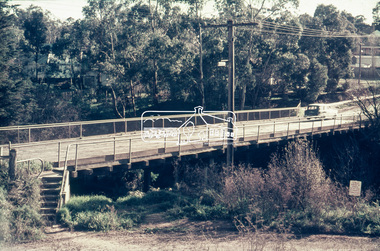
Slide - Photograph, Russell Yeoman, Para Road / Carter Street Bridge over the Plenty River, Briar Hill, c.Jul 1969
... shire of diamond valley... between the Shire of Eltham and the Shire of Diamond Valley... between the Shire of Eltham and the Shire of Diamond Valley ...Bridge over the Plenty River at Briar Hill before widening and alterations. The Plenty River at Briar Hill represented the boundary between the Shire of Eltham and the Shire of Diamond Valley. The bridge was known as the Carter Street Bridge as prior to 1969 Para Road, Briar Hill became Carter Street, Greensborough across the river. It was at this time that the name Para Road was continued and replaced Carter Street.35mm colour positive transparency blue Agfacolour Service plastic mount1969-07, briar hill, carter street bridge, para road, para road bridge, shire of diamond valley, shire of eltham, bridge, plenty river, shire of eltham pioneers photograph collection -
 Eltham District Historical Society Inc
Negative - Photograph, Russell Yeoman, Para Road / Carter Street Bridge over the Plenty River, Briar Hill, c.Jul. 1969
... shire of diamond valley... between the Shire of Eltham and the Shire of Diamond Valley... between the Shire of Eltham and the Shire of Diamond Valley ...Bridge over the Plenty River at Briar Hill before widening and alterations. The Plenty River at Briar Hill represented the boundary between the Shire of Eltham and the Shire of Diamond Valley. The bridge was known as the Carter Street Bridge as prior to 1969 Para Road, Briar Hill became Carter Street, Greensborough across the river. It was at this time that the name Para Road was continued and replaced Carter Street.This photo forms part of a collection of photographs gathered by the Shire of Eltham for their centenary project book,"Pioneers and Painters: 100 years of the Shire of Eltham" by Alan Marshall (1971). The collection of over 500 images is held in partnership between Eltham District Historical Society and Yarra Plenty Regional Library (Eltham Library) and is now formally known as the 'The Shire of Eltham Pioneers Photograph Collection.' It is significant in being the first community sourced collection representing the places and people of the Shire's first one hundred years.Digital image 35 mm B&W negativeshire of eltham pioneers photograph collection, briar hill, 1969-07, bridge, carter street bridge, para road, para road bridge, plenty river, shire of diamond valley, shire of eltham -
![Book - Map, Land Conservation Council, Melbourne Study Area Report, [December 1973]](/media/collectors/4f729f7b97f83e03086018a5/items/6469bc241d76dd4b008a829f/item-media/646b0013d841f8920fa4323c/item-fit-380x285.jpg) Eltham District Historical Society Inc
Eltham District Historical Society IncBook - Map, Land Conservation Council, Melbourne Study Area Report, [December 1973]
... Shire of Diamond Valley... melbourne maps Shire of Diamond Valley population geology topography ...The Melbourne Study Report is a series of volumes describing the physical nature of the land and its environment, examines the likely forms of land use, and assesses the hazards associated with these uses. This is Volume 2 (coloured maps). The first page featues a black and white map described as "Shire of Diamond Valley" with public land marked in yellow. Followed by eight large fold out maps. Melbourne Study Area Public land and descriptive blocks, Population description, Geology, Physiography, topography and rainfall, vegetation and water supply. The Land Conservation Act 1970 established the Land Conservation Council whose functions is to "carry out investigations and make recommendations to the Minister with respect to the use of public land in order to provide for the balanced use of land in Victoria. This report sets out to describe and assess the natural resources of the public lands in the Melbourne area and provides a factual basis on which members of the community may base submissions to the [Land Conservation] Council of Victoria.A collection of eight large fold out coloured maps published in a bound book formnon-fictionThe Melbourne Study Report is a series of volumes describing the physical nature of the land and its environment, examines the likely forms of land use, and assesses the hazards associated with these uses. This is Volume 2 (coloured maps). The first page featues a black and white map described as "Shire of Diamond Valley" with public land marked in yellow. Followed by eight large fold out maps. Melbourne Study Area Public land and descriptive blocks, Population description, Geology, Physiography, topography and rainfall, vegetation and water supply. The Land Conservation Act 1970 established the Land Conservation Council whose functions is to "carry out investigations and make recommendations to the Minister with respect to the use of public land in order to provide for the balanced use of land in Victoria. This report sets out to describe and assess the natural resources of the public lands in the Melbourne area and provides a factual basis on which members of the community may base submissions to the [Land Conservation] Council of Victoria. maps, shire of diamond valley, population, geology, topography, rainfall, vegetation, water supply, land use, public lands -
 Eltham District Historical Society Inc
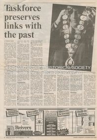
Document - News Clipping, Natalie Town, Taskforce preserves links with the past, Diamond Valley News, September 11, p8, 1996
... Shire of Diamond Valley... Chain Peter Williams Roma O'Callaghan Shire of Diamond Valley ...About former Shire / City council memorabilia. On the reverse side an article "Timing was the problem: chief" regarding Nillumbik CEO Barry Rochford dismissing claims that coulcil failed to follow correct statutory procedure when announcing the release of development plans for thje former Eltham Shire Office site in which developer Dallas Howgate intended to build a service station, convenience store, fast food outlet and community facilities including an information desk and meeting area.895 main road, barry rochford, bev marshall, dallas howgate, eltham shire office, nillumbik shire council, banyule city council, city of heidelberg, david hay, heidelberg historical society, honour board, joint memorabilia taskforce, mayoral chain, peter williams, roma o'callaghan, shire of diamond valley, shire of eltham -
 Eltham District Historical Society Inc
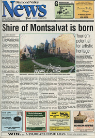
Newspaper - Newspaper article, Diamond Valley News, Shire of Montsalvat is born by Duska Sulicich, Diamond Valley News, October 26, p1, 1994
... Shire of Diamond Valley... of Diamond Valley Shire of Montsalvat Shire of Nillumbik Newsprint ...montsalvat, local government board, council amalgamation, 1994, city of banyule, city of heidelberg, shire of eltham, shire of diamond valley, shire of montsalvat, shire of nillumbik -
 Eltham District Historical Society Inc
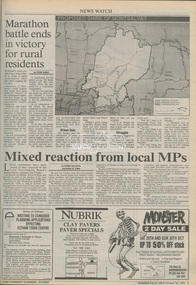
Newspaper - Newspaper article, Diamond Valley News, Marathon battle ends in victory for rural residents by Fiona Kaegi, Diamond Valley News, October 26, p3, 1994
... Shire of Diamond Valley... Government Board Montsalvat Shire of Diamond Valley Newsprint ...council amalgamation, shire of eltham, shire of montsalvat, shire of nillumbik, 1994, city of banyule, city of heidelberg, local government board, montsalvat, shire of diamond valley -
 Eltham District Historical Society Inc
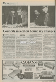
Newspaper - Newspaper article, Diamond Valley News, Councils mixed on boundary changes by Fiona Kaegi and Natalie Town, Diamond Valley News, October 26, p8, 1994
... Shire of Diamond Valley... Government Board Montsalvat Shire of Diamond Valley Newsprint ...council amalgamation, shire of eltham, shire of montsalvat, shire of nillumbik, 1994, city of banyule, city of heidelberg, local government board, montsalvat, shire of diamond valley -
 Eltham District Historical Society Inc
Newspaper - Newspaper article, Diamond Valley News, Board's report considered growth patterns: Burke by John Dubois, Diamond Valley News, October 26, p9, 1994
... Shire of Diamond Valley... Government Board Montsalvat Shire of Diamond Valley Newsprint ...council amalgamation, shire of eltham, shire of montsalvat, shire of nillumbik, 1994, city of banyule, city of heidelberg, local government board, montsalvat, shire of diamond valley -
 Eltham District Historical Society Inc
Newspaper - Newspaper article, Diamond Valley News, Residents gather to challenge new shire by Duska Sulichich, Diamond Valley News, November 2, p1, 1994
... , Diamond Valley News, November 2, p1...Shire of Diamond Valley... Government Board Montsalvat Shire of Diamond Valley Newsprint ...council amalgamation, shire of eltham, shire of montsalvat, shire of nillumbik, 1994, city of banyule, city of heidelberg, local government board, montsalvat, shire of diamond valley -
 Eltham District Historical Society Inc
Newspaper - Newspaper article, Diamond Valley News, Contentious conclusion; fears about new shire by Duska Sulichich, Diamond Valley News, November 2, p8, 1994
... Sulichich, Diamond Valley News, November 2, p8...Shire of Diamond Valley... Government Board Montsalvat Shire of Diamond Valley Newsprint ...council amalgamation, shire of eltham, shire of montsalvat, shire of nillumbik, 1994, city of banyule, city of heidelberg, local government board, montsalvat, shire of diamond valley -
 Eltham District Historical Society Inc
Newspaper - Newspaper article, Diamond Valley News, Rearguard action to stay in shire by Fiona Kaegi, Diamond Valley News, November 9, p7, 1994
... Rearguard action to stay in shire by Fiona Kaegi, Diamond...Shire of Diamond Valley... Government Board Montsalvat Shire of Diamond Valley Newsprint ...council amalgamation, shire of eltham, shire of montsalvat, shire of nillumbik, 1994, city of banyule, city of heidelberg, local government board, montsalvat, shire of diamond valley -
 Eltham District Historical Society Inc
Newspaper - Newspaper article, Diamond Valley News, Eltham rejects west poll by Fiona Kaegi, Diamond Valley News, November 16, p1, 1994
... Shire of Diamond Valley... Government Board Montsalvat Shire of Diamond Valley Newsprint ...council amalgamation, shire of eltham, shire of montsalvat, shire of nillumbik, 1994, city of banyule, city of heidelberg, local government board, montsalvat, shire of diamond valley -
 Eltham District Historical Society Inc
Newspaper - Newspaper article, Diamond Valley News, West riding votes for Montsalvat by Fiona Kaegi, Diamond Valley News, November 16, p5, 1994
... Shire of Diamond Valley... Government Board Montsalvat Shire of Diamond Valley Newsprint ...council amalgamation, shire of eltham, shire of montsalvat, shire of nillumbik, 1994, city of banyule, city of heidelberg, local government board, montsalvat, shire of diamond valley -
 Eltham District Historical Society Inc
Newspaper - Newspaper article, Diamond Valley News, Shire approves border changes by Natalie Town, Diamond Valley News, November 16, p7, 1994
... Shire of Diamond Valley... Government Board Montsalvat Shire of Diamond Valley Newsprint ...council amalgamation, shire of eltham, shire of montsalvat, shire of nillumbik, 1994, city of banyule, city of heidelberg, local government board, montsalvat, shire of diamond valley -
 Eltham District Historical Society Inc
Newspaper - Newspaper article, Diamond Valley News, Shire now Nillumbik by Natalie Town, Diamond Valley News, November 23, p3, 1994
... Shire of Diamond Valley... Government Board Montsalvat Shire of Diamond Valley Newsprint ...council amalgamation, shire of eltham, shire of montsalvat, shire of nillumbik, 1994, city of banyule, city of heidelberg, local government board, montsalvat, shire of diamond valley -
 Eltham District Historical Society Inc
Newspaper - Newspaper article, Diamond Valley News, Last ditch submission by Fiona Kaegi, Diamond Valley News, November 23, p7, 1994
... Shire of Diamond Valley... Montsalvat Shire of Diamond Valley Newsprint; Newspaper, bound volume ...And - Campaign not 'too late' to suceedcouncil amalgamation, shire of eltham, shire of montsalvat, shire of nillumbik, 1994, city of banyule, city of heidelberg, local government board, montsalvat, shire of diamond valley -
 Eltham District Historical Society Inc
Newspaper - Newspaper article, Diamond Valley News, New police station plan by Jodie Haythorne, Diamond Valley News, November 30, p3, 1994
... Shire of Diamond Valley... Government Board Montsalvat Shire of Diamond Valley Police Station ...council amalgamation, shire of eltham, shire of montsalvat, shire of nillumbik, 1994, city of banyule, city of heidelberg, local government board, montsalvat, shire of diamond valley, police station, shire of eltham office site