Showing 241 items
matching site survey
-
 Port Melbourne Historical & Preservation Society
Letter - re Site of Sandridge Municipal Council Chambers, 5 Oct 1860
Handwritten letter advising of the proclamation of the site for Municipal Council Chambers at Sandridge 5th October 1860local government - municipal district of sandridge, built environment - zoning, department of lands and survey, clement hodgkinson -
Port Melbourne Historical & Preservation Society
Letter - Department of Lands and Survey granting land for temporary reserve, 18 Mar 1860
Handwritten letter from Dept of Lands and Survey granting Crown land for temporary reserve as site for abattoirs 18 March 1861local government - borough of sandridge, industry - noxious, department of lands and surveys, clement hodgkinson -
Port Melbourne Historical & Preservation Society
Letter - Department of Lands and Survey re notification of crown grants for Sandridge municipal chambers and market site, Department of Lands and Survey, 20 Jun 1862
Handwritten letter on blue foolscap laid paper, from Dept of Lands and Survey 20.6.1862 notifying Town Clerk of two crown grants, for municpal chambers and for market site. Paper watermarked A.Cowan & Sons 1855Notations in pencil on back, upper leftlocal government - borough of sandridge, market reserve, port melbourne town hall -
Port Melbourne Historical & Preservation Society
Letter - Department of Lands and Survey re proclaimation for site of Town Hall, Sandridge, Department of Lands and Survey, 30 Dec 1861
... Department of Lands and Survey re proclaimation for site of... and Survey re proclaimation for site of Town Hall, Sandridge ...Handwritten letter on blue foolscap laid paper, from Dept of Lands and Survey 30.12.1861 directing attention to proclamation in Government Gazette re site for Town Hall at Sandridge. Paper, watermarked with Britannia symbollocal government - borough of sandridge, port melbourne town hall -
Port Melbourne Historical & Preservation Society
Letter - Department of Lands and Survey re proclaimation for site of Sandridge municipal common, Department of Lands and Survey, 10 Oct 1863
... Department of Lands and Survey re proclaimation for site of... and Survey 10.10.1863, directing attention to proclamation ...Handwritten letter on blue foolscap laid paper, from Dept of Lands and Survey 10.10.1863, directing attention to proclamation in Government Gazette re site for Sandridge municipal common. Paper, watermarked TH Saunders 1862local government - borough of sandridge, port melbourne town hall -
 Port Melbourne Historical & Preservation Society
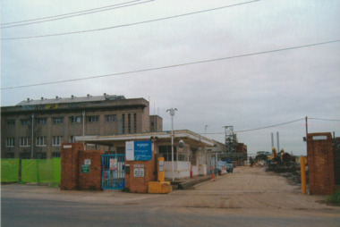
Photograph - J Kitchen & Sons perimeter survey, Williamstown Road and Normanby Road, Dec 2013
As the former j Kitchen & Sons site was being cleared, Lionel Layfield, who had worked at the site for many years undertook several pictorial perimeter surveys. These photos were taken in Dec 2013.Series 1 of colour photographs taken by Lionel Layfield as he walked around the perimeter of the J Kitchen & Sons Pty Ltd factory site during the early demolition of most of the buildings. .01-.08 - corner of Williamstown Road and Normanby Road to Ingles Streetindustry - manufacturing, built environment - industrial, business and traders - soaps/candles, demolitions, j kitchen & sons pty ltd, symex holdings ltd, north port oval, port melbourne cricket and football oval -
 Port Melbourne Historical & Preservation Society
Photograph - J Kitchen & Sons perimeter survey, Munro Street, Dec 2013
As the former j Kitchen & Sons site was being cleared, Lionel Layfield, who had worked at the site for many years undertook several pictorial perimeter surveys. These photos were taken in Dec 2013.Series 1 of colour photographs taken by Lionel Layfield as he walked around the perimeter of the J Kitchen & Sons Pty Ltd factory site during the early demolition of most of the buildings. .09-.15 - from Munro St entrance by the weighbridgeindustry - manufacturing, built environment - industrial, business and traders - soaps/candles, demolitions, j kitchen & sons pty ltd, symex holdings ltd, north port oval, port melbourne cricket and football oval -
 Port Melbourne Historical & Preservation Society
Photograph - J Kitchen & Sons perimeter survey, Ingles Street, Dec 2013
As the former j Kitchen & Sons site was being cleared, Lionel Layfield, who had worked at the site for many years undertook several pictorial perimeter surveys. These photos were taken in Dec 2013.Series 1 of colour photographs taken by Lionel Layfield as he walked around the perimeter of the J Kitchen & Sons Pty Ltd factory site during the early demolition of most of the buildings. .16-.30- from Munro St along Ingles Street to Woodruff Streetindustry - manufacturing, built environment - industrial, business and traders - soaps/candles, demolitions, j kitchen & sons pty ltd, symex holdings ltd, north port oval, port melbourne cricket and football oval -
 Port Melbourne Historical & Preservation Society
Photograph - J Kitchen & Sons perimeter survey, Woodruff Street, Dec 2013
As the former j Kitchen & Sons site was being cleared, Lionel Layfield, who had worked at the site for many years undertook several pictorial perimeter surveys. These photos were taken in Dec 2013.Series 1 of colour photographs taken by Lionel Layfield as he walked around the perimeter of the J Kitchen & Sons Pty Ltd factory site during the early demolition of most of the buildings. .31-.36 - looking into the factory site from Woodruff Streetindustry - manufacturing, built environment - industrial, business and traders - soaps/candles, j kitchen & sons pty ltd, symex holdings ltd, north port oval, port melbourne cricket and football oval -
 Port Melbourne Historical & Preservation Society
Photograph - J Kitchen & Sons perimeter survey, Boundary Street, Dec 2013
As the former j Kitchen & Sons site was being cleared, Lionel Layfield, who had worked at the site for many years undertook several pictorial perimeter surveys. These photos were taken in Dec 2013.Series 1 of colour photographs taken by Lionel Layfield as he walked around the perimeter of the J Kitchen & Sons Pty Ltd factory site during the early demolition of most of the buildings. .37-.45 - along Boundary Street past White Street to Normanby Roadindustry - manufacturing, built environment - industrial, business and traders - soaps/candles, j kitchen & sons pty ltd, symex holdings ltd, north port oval, port melbourne cricket and football oval -
 Port Melbourne Historical & Preservation Society
Photograph - J Kitchen & Sons perimeter survey, north corner Ingles and Woodruff Streets, Dec 2013
As the former j Kitchen & Sons site was being cleared, Lionel Layfield, who had worked at the site for many years undertook several pictorial perimeter surveys. These photos were taken in Dec 2013.Series 1 of colour photographs taken by Lionel Layfield as he walked around the perimeter of the J Kitchen & Sons Pty Ltd factory site during the early demolition of most of the buildings. .46-.54- warehouse on North corner of Ingles and Woodruff streetsindustry - manufacturing, built environment - industrial, business and traders - soaps/candles, j kitchen & sons pty ltd, symex holdings ltd, north port oval, port melbourne cricket and football oval -
Port Melbourne Historical & Preservation Society
Photograph - J Kitchen & Sons perimeter survey, from North Port Oval, Dec 2013
As the former j Kitchen & Sons site was being cleared, Lionel Layfield, who had worked at the site for many years undertook several pictorial perimeter surveys. These photos were taken in Dec 2013.Series 1 of colour photographs taken by Lionel Layfield as he walked around the perimeter of the J Kitchen & Sons Pty Ltd factory site during the early demolition of most of the buildings. .55-.60 - panorama looking towards Kitchens (city views behind) from Port Melbourne football groundindustry - manufacturing, built environment - industrial, business and traders - soaps/candles, j kitchen & sons pty ltd, symex holdings ltd, north port oval, port melbourne cricket and football oval -
 Port Melbourne Historical & Preservation Society
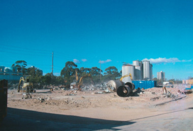
Photograph - Demolition, J Kitchen & Sons perimeter survey, May 2014
As the former j Kitchen & Sons site was being cleared, Lionel Layfield, who had worked at the site for many years undertook several pictorial perimeter surveys. These photos were taken c. May 2014.Series 2 of colour photographs taken by Lionel Layfield again walking around the perimeter of J Kitchen and Sons, but several months later than series 1, and so demolition has progressed. Many photos show bricks, bluestone and other salvage materials. Photos .10 and .11 include the old bomb shelter.industry - manufacturing, built environment - industrial, demolitions, j kitchen & sons pty ltd -
 Port Melbourne Historical & Preservation Society
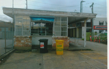
Photograph - Demolition, J Kitchen & Sons perimeter survey, Jul 2014
As the former j Kitchen & Sons site was being cleared, Lionel Layfield, who had worked at the site for many years undertook several pictorial perimeter surveys. These photos were taken July 2014.Series 3 of colour photographs taken by Lionel Layfield again walking around the perimeter of J Kitchen and Sons during demolition (later than series 2) . In particular the photographs show the weighbridge, as it was still functioning for the demolition trucks. Details of the interior refer to the weighbridge scales, security and customs associated functions.industry - manufacturing, built environment - industrial, transport - motor vehicles, j kitchen & sons pty ltd -
 Port Melbourne Historical & Preservation Society
Photograph - Demolition, J Kitchen & Sons perimeter survey, Jul 2014
As the former j Kitchen & Sons site was being cleared, Lionel Layfield, who had worked at the site for many years undertook several pictorial perimeter surveys. These photos were taken July 2014.Series 4 of colour photographs taken by Lionel Layfield again walking around the perimeter of J Kitchen and Sons during demolition (later than series 3) .industry - manufacturing, built environment - industrial, demolitions, j kitchen & sons pty ltd -
 Coal Creek Community Park & Museum
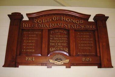
Honour Roll, Kilcunda Road School Honor Roll
This WWI Honor Roll was originally displayed in the Kilcunda Road State School (no.3337), which was located at the north east corner of the intersection of the Bena - Kongwak and Buchanans' Roads, Bena, Victoria, 3946. The school was located amongst the cypress trees at 645 Bena-Kongwak Road. The school was relocated in 2008 to the Coal Creek Community Park and Museum, 12 Silkstone Road, Korumburra, 3950 to become the Masonic Lodge building in the park display. On the west side of the intersection of the Bena - Kongwak and Buchanans' Roads is a brass plaque on a granite boulder with the following inscription TO COMMEMORATE THE DISTRICT OF KILCUNDA ROAD First Surveyed 1879. This is the site of the KILCUNDA ROAD UNITING CHURCH 1911 to 1966. Diagonally opposite at 645 Bena-Kongwak Road was the site of the KILCUNDA ROAD PRIMARY SCHOOL No: 3337, 1902 to 1975. Erected by The School Mother’s Club continuing as The Kilcunda Road Social Club 2008. One of the few remaining historic items from Kilcunda Road settlement.Honour roll of varnished wood, with three panels, an undulating shaped pediment, plain columns at sides, painted gold text and the Australian Imperial Forces insignia on base.Roll of Honor, Kilcunda Road State School. In Honor of Old Scholars of this school who served the Empire in the Great War, 1914-1919, Australian Imperial Force. (X) These made the supreme sacrifice. Sister J.E. Turner , E.N. Barge, E.F. Binding (X), E.H. Bunn, D. James (X), W.James, A. James (X), R. H. James, A.G. Rose (X), C.W. Stanlake, G. Wuchatsch, R. Wuchatsch, T.E. Young kilcunda road, honour roll, state school no.3337., wwi -
 Bendigo Historical Society Inc.
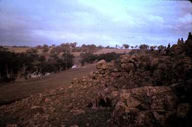
Slide - DAVID MCDONALD COLLECTION: EPPALOCK. CONSTRUCTION, c1960
Eppalock. Construction. On the right of the slide on top of the mound are at least 3 adults and 7 children surveying what has been done. Markings: Eppalock Dam site 1960.Kodakcivil engineering, water supply, eppalock -
 Bendigo Historical Society Inc.
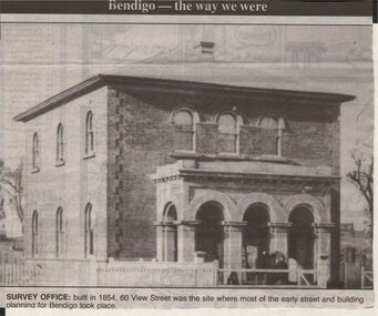
Newspaper - JENNY FOLEY COLLECTION: SURVEY OFFICE
Bendigo Advertiser "The way we were" from 1999. Survey Office: built in 1854, 60 View Streeet was the site where most of the early street and buiolding planning for Bendigo took place.newspaper, bendigo advertiser, the way we were -
 Bendigo Historical Society Inc.
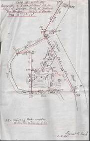
Plan - MCCOLL, RANKIN AND STANISTREET COLLECTION: PLAN OF SURVEY OF DAM SITE, 1941
... MCCOLL, RANKIN AND STANISTREET COLLECTION: PLAN OF SURVEY... Plan of Survey of Dam site...McColl Rankin & Stanistreet, Plan of Survey of Dam site... & Stanistreet Plan of Survey of Dam site McColl Rankin & Stanistreet ...McColl Rankin & Stanistreet, Plan of Survey of Dam site, Part of Crown Allotment 98 Section C, City of Bendigo, Parish of Sandhurst, County of Bendigo. Signed by Garnet G Birch 1 Feb 1941. 33.5 x 43. Attached is a Copy of Field notes, Dam Site in Crown Allotment 198 Sec. City of Bendigo, Parish of Sandhurst. True Meridian, County of Bendigo, Area 0A 1R 16P. Signed Garnet G Birch, 1/2/1941. Drawn in red and black pen. 20.8 x 33. Both maps are for Deborah Extended Gold Mining Co. No Liabilityorganization, mining, deborah extended gold mining co nl, mccoll rankin & stanistreet, plan of survey of dam site -
 Victorian Interpretive Projects Inc.
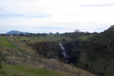
Photograph - Photograph - Colour, Clare Gervasoni, Lal Lal Falls, Victoria, 2014, 09/2014
Lal Lal Falls Reserve contains one of the most spectacular waterfalls in the Moorabool Shite. The watefall is part of the on Lal Lal Creek, a tributary of the Moorabool River. and plunges 30 metres from a high basalt column into a deep ravine. Culturally, the Falls are believed to be the earthly home of Bunjil, the All Father or Creator to most Victorian Aboriginal tribes. The name Lal Lal is thought to be Aboriginal for "dashing of waters". The Lal Lal Falls is listed on the Site Registry of Aboriginal Affairs Victoria as a spiritual place. in 1837 a Government Survey Party led by Frederick D'Arcy documented these Falls on the west branch of the Moorabool River. On the reserve opposite, a Race Meeting was held on every New Years Day from 1860 until 1938, attracting crowds of up to 20,000 people. A branch Railway Line was constructed from the Lal Lal station to the Racecourse to convey the crowds.Colour photographs of Lal Lal Falls near Ballarat, Victoria.lal lal falls, waterfall, lal lal, bunjil -
 Hepburn Shire Council Art and Heritage Collection
Public Art Work, 'Wombat' - Miriam Porter. 2013, 2012 - 2013
... of alluvial gold a town site was surveyed and founded in 1852 ...Commissioned by the Friends of Wombat Hill Botanical Gardens and gifted to the Hepburn Shire in 2012. Historical Significance - In 1848, Irish immigrant John Egan took up land on the future town site then known as Wombat Flat. He and a party of searchers found alluvial gold in 1851 on ground now covered by Lake Daylesford initiating the local gold rush. Other finds quickly followed. With the finding of alluvial gold a town site was surveyed and founded in 1852. Initially called Wombat, it was renamed Daylesford. Cultural and Artistic Significance - Miriam Porter's 'Wombat' is a symbol of the Wombat Hill Botanical Gardens where visitors and locals alike love being photographed. Large scale solid redgum wombat sculpture.Artist intends to sign the work with 'M' on one leg.daylesford, hepburn shire, public art, miriam porter, wombat, art, sculpture, red gum, australian wood, australia, tourist attraction -
Clunes Museum
Plan
PLAN HAS AN ATTACHED HAND PRINTED CARD WITH INFORMATION REGARDING SITES. THIS HAS BEEN ADDED AT A MUCH LATER DATE.1 PAGE - AN EARLY, UNDATED PLAN OF THE TOWNSHIP OF CLUNES, COUNTY OF TALBOT, SHOWING REDUCED LEVELS AND CHAIN SURVEY OF ALL SECTIONSlocal history, plans -
Stawell Historical Society Inc
Map, Department of Lands & Survey J. Noone, Township of Heatherlie. Parish of Baroka. County of Borung 1888, 1888
Stawell & Grampians Freestone Quarry Company Railway Reserve. Cross & masons Quarry Site. Mamnager'sHouse, Stead's boarding House Stawell and Grampians railwaySurveyed Township Showing Quarry and railway Reservephoto Lithographed at the Department of lands and Survey Melbourne By J Noone 15.6.88railway quarry -
Koorie Heritage Trust
Document - Printed Sheets, Bennett, Catherine, A report on the Aboriginal Skeletal Remains from the Chenery Burial, near Skipton, Site Number: 7522/20, 1987
29 P.; Appendices; plates; figs.; tables; refs.; 33 cm.skeletal remains-aboriginal-chenery near skipton vic. -
Koorie Heritage Trust
Document - Printed Sheets, Bennett, Catherine et al, Report on Aboriginal Skeletal Remains from Tarwin Meadows, South Gippsland - site number 80201/043, 1986
30 P.; appendices; maps; figs.; tables; plates; 32 cm.skeletal remains-aboriginal-tarwin meadows-south gippsland, anthropology-aboriginal-south gippsland., victorian archaeological survey-aboriginal skeletal remains -
Koorie Heritage Trust
Book, Aboriginal Affairs Victoria in conjunction with the Kerrup Jmara Elders Aboriginal Corporation, Lake Condah Heritage Management Strategy and Plan, 1993
During its 1977/78 summer field school season, the (then) Victoria Archaeological Survey began recording and mapping the stone fish trap and 'house' sites along the southern margins of Lake Condah, near Portland Victoria. This and subsequent archaeological work at Lake Condah and in the general region demonstrates that, on the basis of a number of criteria, the Aboriginal heritage sites found here are significant.vii, 388 p., [11]. leaves. : ill., foldout maps. ; 30 cm.During its 1977/78 summer field school season, the (then) Victoria Archaeological Survey began recording and mapping the stone fish trap and 'house' sites along the southern margins of Lake Condah, near Portland Victoria. This and subsequent archaeological work at Lake Condah and in the general region demonstrates that, on the basis of a number of criteria, the Aboriginal heritage sites found here are significant.conservation of natural resources -- victoria -- condah, lake, region. | aboriginal australians -- victoria -- condah, lake, region -- antiquities. -
Koorie Heritage Trust
Book, Burke, Christine, Analysis of the lithic assemblage from the Keilor archaeological site : site number : 7822/010, 1990
58 P. appendices; bib. graphs; figs. map.sites - conservation and protection. | keilor /? maribyrnong river (melbourne vic sj55-05) | excavations (archaeology) -- australia -- melbourne (vic.) sites - conservation and protection -
Whitehorse Historical Society Inc.
Document, List of significant sites in Nunawading, c1994
Non annotated list - probably prepared in preparation for the City of Nunawading Heritage Survey Project.Non annotated list - probably prepared in preparation for the City of Nunawading Heritage Survey Project.Non annotated list - probably prepared in preparation for the City of Nunawading Heritage Survey Project.city of nunawading heritage survey, arrowsmith, valda -
 Whitehorse Historical Society Inc.
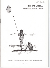
Document, Mt William Archaelogical Area, 1/08/1977 12:00:00 AM
Booklet issued by the Victorian Archaelogical Survey describing an abouiginal axe quarry at Mt William near Lancefield. The history of the site is described as is the archaelogical evidence.Booklet issued by the Victorian Archaelogical Survey describing an abouiginal axe quarry at Mt William near Lancefield. The history of the site is described as is the archaelogical evidence. A section describes the importance of axes in aboriginal culture. Map, illustrations.Booklet issued by the Victorian Archaelogical Survey describing an abouiginal axe quarry at Mt William near Lancefield. The history of the site is described as is the archaelogical evidence. aborigines, stone axes, mount william -
 Whitehorse Historical Society Inc.
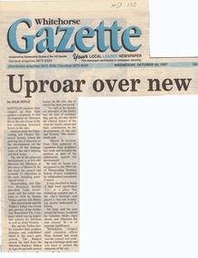
Article, Uproar over new units, 29/10/1997 12:00:00 AM
Mitcham residents and the Nunawading and District Historical SocietyMitcham residents and the Nunawading and District Historical Society have joined the growing list of objectors to a proposed 16 unit development at the corner of Mitcham Road and Meerut Street on the site of one of the few remaining historical homes in the area. The house was built in 1934 by Stanley and Helen Walker. Mr Walker's family was owner and operator of the Australian Tessellated Tile Company, an important industry for Mitcham and Victoria. The house was recognised in the 1994 City of Nunawading Heritage Survey Project and was classified as being of high local significance,Mitcham residents and the Nunawading and District Historical Societymitcham road, mitcham, meerut street, walker, stanley, helen, arrowsmith, valda, daly, peter, seamer