Showing 516 items matching "strait"
-
 Lakes Entrance Historical Society
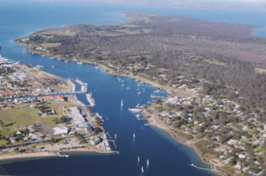
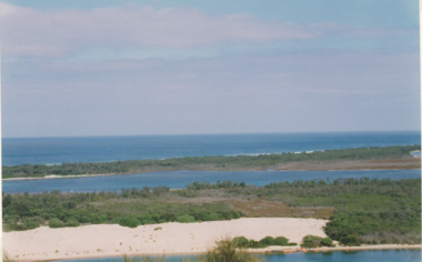
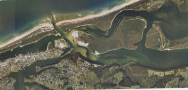
Photograph - McMillan Strait, 2005 c
Colour aerial photograph of McMillan Strait between Paynesville on left and Raymond Island on right on Gippsland Lakes Victoriaaerial photograph, township -
 Port Melbourne Historical & Preservation Society
Photograph - Various ferries working from Station Pier, Port Melbourne, Ron Laing, 1986 - 1999
A set of 38 photographs of various ferries (Bass Strait and local) which worked from Station Pier 1986-1999transport - ferries, piers and wharves - station pier, ron laing, abel tasman, incat 45, incat 46, incat 47, pollux, rip, south steyne, spirit of tasmania, spirit of victoria, wattle, franklin, australian endeavour, australian endurance -
 Lakes Entrance Historical Society
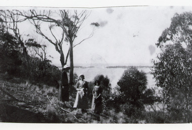
Photograph, 1920c
Black and white photograph showing three women at viewing site Kalimna of the Entrance to Bass Strait from the Gippsland Lakeswaterways, topography, people -
 Lakes Entrance Historical Society
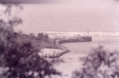
Photograph - The Entrance, Fish Marie, 1995
Black and white photograph of the eastern rock wall of the entrance to Bass Strait from the Gippsland Lakes, at Lakes Entrance, Victoria. waterways, boats and boating -
Lakes Entrance Historical Society
Book, Bringing them Home, 1997
A guide to major themes, findings and recommendations of the National Inquiry into the separation of Aboriginal and Torres Strait Islander children from their families.aboriginals -
 Flagstaff Hill Maritime Museum and Village
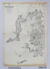
Document - Navigation Chart, Pescadores Islands Inner Anchorage
British Admiralty Navigation Chart - China - Formosa Strait - Pescadores Islands Inner Anchorage, from a French Goverment Survey 1886warrnambool, shipwrecked-coast, flagstaff-hill, flagstaff-hill-maritime-museum, maritime-museum, shipwreck-coast, flagstaff-hill-maritime-village, shipwrecked-artefact, navigation chart, british admiralty navigation chart, british admiralty, pescadores islands inner anchorage -
 Queenscliffe Maritime Museum
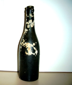
Bottle
Bottle recovered from wreck site of Joseph Sims - wrecked Prime Seal Island, Bass Strait 1/6/1930 -
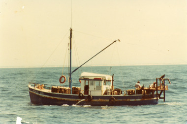
 Lakes Entrance Historical Society
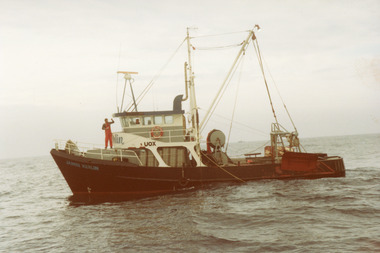
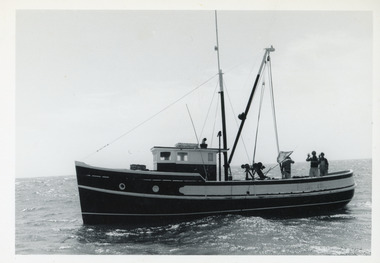
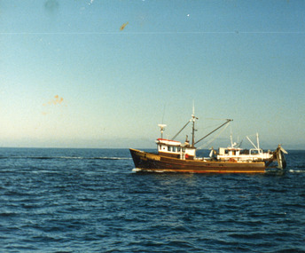
Photograph - Potts, 1980
Colour photograph of the scallop fishing boat Potts, two people on deck, at sea in Bass Strait, off Lakes Entrance, Victoriaboats and boating, fishing industry, ocean -
 Lakes Entrance Historical Society
Photograph - James Kerlin, 1980
Colour photograph of the fishing boat James Kerlin, one person on deck, at sea in Bass Strait off Lakes Entrance Victoria.boats and boating, fishing industry, ocean -
 Lakes Entrance Historical Society
Photograph - Gumleaf, 1970
Gumleaf owner / skipper Jim and Olive AldertonColour photograph of the fishing boat Gumleaf, two crew working on deck, at sea in Bass Strait off Lakes Entrance Victoriaboats and boating, fishing industry, ocean -
Victorian Aboriginal Corporation for Languages
Book, Human Rights and Equal Opportunity Commission, Bringing them home : National Inquiry into the separation of Aboriginal and Torres Straight Islander children from their families, 1997
A tribute to the strengths and struggles of many thousands of Aboriginal and Torres Strait Islander people affected by forcible removal. It acknowledges the hardship they endured and the sacrifices they made. Dedicated to those who found the strength to tell their stories to the Inquiry and to the generations of Aboriginal and Torres Strait Islander people separated from their families and communities. Includes stories and recommendations.maps, b&w photographs, tableschild protection, institutional care, australian aboriginal history, aboriginal children, social justice -
 Phillip Island and District Historical Society Inc.
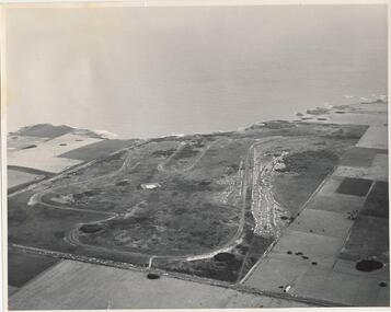
Photograph, J D Payens, Aerial photo of Grand prix track and painting of 1932 Grand Prix
The Circuit was built in the 1950's and opened in 1956. The circuit was closed in 1962 due to lack of finance for repair work to the track. In 1964 Len Lukey purchased the cirtuit and reopened in 1967, but once again was closed in 1978 as not suitable for modern racing. It was used only for Historic Rallies and the like until 1982. In 1985 The Circuit was purchsed by Placetac Pty Ltd. The Circuit was refurbished in 1988. In 1989 The Australian Motorcycle Grand Prix - 1st World Championship Round - was held at the Circuit on 9th April. 2004 the Circuit and surrounding land was purchased by The Linfox Group who still own it to this day (8/10/2016).Black & White aerial view of the Phillip Island Grand Prix Race Track with Bass Strait in the background and painting of 1932 Grand PrixJ. D. Payne - Commercial Photographer, Rice Street, Moorabbin. Phone: XL 3144phillip island g p circuit, grand prix circuit phillip island, len lukey, linfox group, jean parle, bill thompson, keith riordan, bugatti, 1932 grand prix -
 Lakes Entrance Historical Society
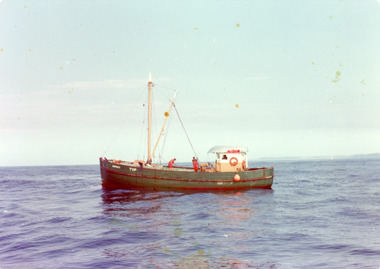
Photograph - Civic Star, 1975
Owner / skipper Civic Star John GuillotBlack and white photograph of the fishing boat Civic Star, three men on deck. At sea in Bass Strait, off Lakes Entrance Victoriaboats and boating, fishing industry -
 Lakes Entrance Historical Society
Photograph - Lakes Entrance, M Holding, 1/03/2004 12:00:00 AM
Colour photograph taken from Kalimna viewing platform from Rigby to outer barrier and Bass Strait beyond, East Gippsland Victoriawaterways, lakes entrance -
 Queenscliffe Maritime Museum
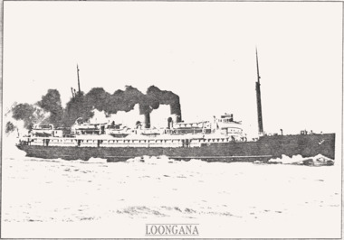
Photograph - B & W photocopy of the LOONGANA & written details, LOONGANA photo & article, c1936 or later
Mail/Passenger ferry, Bass Strait.Bass Strait Ferry serviceB & W photocopy of the LOONGANA & written details.Reverse " NIL "historical references -
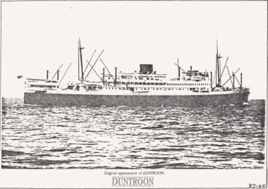 Queenscliffe Maritime Museum
Photograph - B & W photocopy of the DUNTROON & written details, DUNTROON photo & article, c1929 or later
Bass Strait coastal trader vesselBass Strait vessels c1929B & W photocopy of the DUNTROON & written details.Reverse " NIL "historical references -
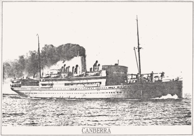 Queenscliffe Maritime Museum
Photograph - B & W photocopy of the ship CANBERRA & written details, CANBERRA photo & article, Between 1912 & 1959
Bass Strait coastal trader vesselPassenger vessel photo & details.B & W copy of a photo of the steamer CANBERRA, photo & details copied from an unknown book.Reverse " NIL "historical references -
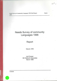 Victorian Aboriginal Corporation for Languages
Book, Judi Cooper, Needs survey of community languages 1996 : report : March 1998, 1998
Report of Needs Survey of Community Languages, including, Methodology, Victoria, NSW, Queensland, Torres Strait Islanders, Western Australia, Northern Territory and summary. -
Lakes Entrance Historical Society
Book, Loney Jack, Wrecks on the Gippsland Coast, 1968
Shipwrecks and incidents along the coast and in Bass Strait from Point Nepean to Cape Howe. Indexes of Ships and Localities included. Some ship illustrated.A J and H Murrell stamped on first pageshipwrecks, ships and shipping, lighthouses -
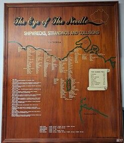 Flagstaff Hill Maritime Museum and Village
Artwork, other - Shipwreck Board, The Eye of the Needle: Shipwrecks, Stranding's and Collisions, ca 2002
The Shipwreck Board is a feature of Flagstaff Hill Maritime Museum and Village/ its subject is explained briefly in the Museum's handbook, The Flagstaff Hill Navigator, published in 2008: - "Known as the ‘Eye of the Needle’ the treacherous entrance to Bass Strait is littered with the wreckage of large international vessels and smaller sail and steam craft used in coastal trade. The vessels bringing emigrants and cargo to Australia found the western entrance to Bass Strait the most dangerous part of their voyage. They had to thread their way between the southern point of Victoria (Cape Otway) and the northern point of King Island, a stretch of water less than 90 km wide. Many smaller coastal vessels were lost at Portland, Port Fairy, Warrnambool and Apollo Bay which are not safe harbours in certain weather conditions. "The Shipwreck Board shows shipwrecks, strandings and collisions which occurred in this area up to the year 1940. Wrecks are identified by a yellow light and collisions/strandings by a green light. These lights also identify the decade the wreck occurred by lighting up when the relevant decade button is pushed. Interesting happenings of the decades are listed next to the buttons." The Shipwreck Board's demonstration of The Eye of the Needle is an interactive visual display that helps teach the perils and dangers faced by early settlers in Victoria. It tells of the vast number of lives lost. It lists the names of many infamous shipwrecks and significant events.The large stained and lacquered timber board is mounted in a timber, frame. It is painted with a small sketch of Australia, and an enlarged outline of the southern coast of Victoria, King Island and the North West coast of Tasmania. The interactive display highlights the shipwrecks, standings and collisions suffered by many vessels as they navigated the 'Eye of the Needle', a narrow stretch of Bass Strait. The locations of the Lighthouses are pinpointed. Lists of groups of ships are below the coastlines. A painted scroll shows eight major shipwrecks with the number of lives lost for each one. A table shows historical facts associated with the decades from pre-1830 to 1940. A system of coloured lights compares the decades with the vessels that suffered damage. The board was created by artist and signwriter, Alex O'Flynn Computer Signs.flagstaff hill, maritime museum, maritime village, shipwreck coast, eye of the needle, shipwreck locations, bass strait, basses strait, king island, north west tasmania, south coast of victoria, cape otway, victorian lighthouse, king island lighthouse, strandings, coastal tracers, emigrant ships, sea trade, 1930s-1940s, shipwreck board, the eye of the needle, collosions, alex o'flynn, alex o’flynn computer signs, shipwrecks of western victoria -
Queenscliffe Maritime Museum
Photograph - Photographs 5
Princess of Tasmania operated for 19 years across Bass Strait from 1952 to 1972 Empress of Tasmania operated for 14 years across Bass Strait from 1972 to 1986 when it was replaced by the Abel Tasman which still operatingVessels operated through the Rip and Port Phillip for 19 and 14 years respectively 5 Photographs: 1. MV Princess of Tasmania, 2. MV Empress of Australia, 3. Rip in 1951, 4. PV Akuna, 5. unknown phototasmanian ferry, mv princess of tasmania, mv empress of australia, pv akuna, storms, rip -
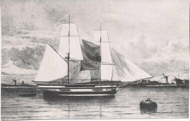 Phillip Island and District Historical Society Inc.
Photograph
One of a collection of over 400 photographs in an album commenced in 1960 and presented to the Phillip Island & Westernport Historical Society by the Shire of Phillip IslandPhotograph of a painting of The Lady Nelson with a buoy in the foreground and windmills on the shore in the background. The "Lady Nelson" was the first ship to sail Bass Strait from West to East.local history, photography, photographs, maritime technology, boats, sailing ship - lady nelson, black & white photograph, sailing ships, lady nelson, john jenner, bryant west -
Port Melbourne Historical & Preservation Society
Photograph - Demolition of Centenary Bridge, 1991
Twenty One (21) colour photographs of demolition of Centenary Bridge and redevelopment of Station Pier to create roll on/roll off facility for Bass Strait ferries.piers and wharves - station pier, engineering - bridges, centenary bridge, abel tasman, station pier gatehouse, princes street -
 Lakes Entrance Historical Society
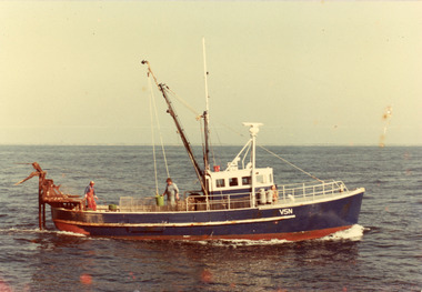
Photograph - Komuta, 1975c
Owner 1980's SotirakisColour photograph of the scallop fishing boat Komuta in Bass Strait. Bagged scallops on deck, two men sorting at the dredge table. Lakes Entrance Victoriafishing industry, ships and shipping, ocean -
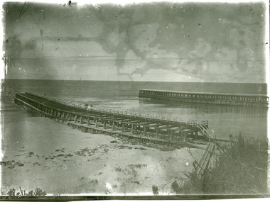 Lakes Entrance Historical Society
Photograph - Entrance Piers, 1905c
Black and white photograph showing piers and entrance to Gippsland Lakes from ocean Bass Strait. Few people on boardwalk on piers. Lakes Entrance Victoriaboardwalk, waterways, piers -
 Lakes Entrance Historical Society
Photograph - The Entrance, 1919
Black and white photograph showing entrance to Gippsland Lakes from ocean - Bass Strait. Beach on left side of Eastern Pier. Lakes Entrance Victoriapiers, waterways -
 Lakes Entrance Historical Society
Photograph - Lakes Entrance, Gippsland Ports, 2006 c
Colour aerial photograph showing view of entrance to Gippsland Lakes from Bass Strait Reeves Channel Rigby Island and township of Lakes Entrance Victoriaaerial photograph, historic site, dredging, waterways, lakes entrance -
 Lakes Entrance Historical Society
Photograph - Sand Groper, 1980c
Owner Keith Bonds from NungurnerColour photograph of the scallop fishing boat Sand Groper working the scallop beds in Bass Strait. Boat in background working in opposite direction. Lakes Entrance Victoriafishing industry, ships and shipping, waterways -
 Lakes Entrance Historical Society
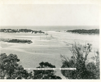
Photograph - The Entrance, Martin Orville, 1940c
Another copy Black and white 7 x 8.5 with inscription'View showing the Entrance, Lakes Entrance, Vic'Black and white photograph of Bullock Island, the New Works, township and entrance from Bass Strait to the Gippsland Lakes. Taken at high tide. Lakes Entrance Victoriaislands, waterways, topography -
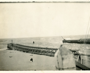
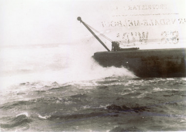 Lakes Entrance Historical Society
Photograph, 1910c
Also one other copy 9 x 12.5 cmBlack and white photograph showing ocean and southern end of western pier at entrance to Gippsland Lakes from Bass Strait, in heavy seas at Lakes Entrance, Victoria,piers, waterways