Showing 134 items matching "survey reserve"
-
 University of Melbourne, Burnley Campus Archives
Plan - Photocopy, Proposed Reserve for Horticultural and Experimental Garden in the Survey Paddock Richmond, 1862-1948
Photocopy of Plan Gazetted 01.08.1863. From Central Plan Office Department of Natural Resources.Original signed by Clement Hodgkinson, Deputy Surveyor General. Stamped Department of Lands and Survey 7.12.48 Neg.18377. Handwritten notes on back "Melb Roll 23, R.19(A)"burnley, horticultural and experimental garden, survey paddock, richmond, clement hodgkinson -
 Bendigo Historical Society Inc.
Document - Geological Survey of Victoria, Hustlers Line of Reef, Bendigo, April, 2014
Seven men were killed at the Great Extended Hustler's mine disaster on 2nd May 1914 by an explosion of dynamite occurring as the men were waiting at the plat to ascend the mine at the end of their shift. No blame was attached to anyone in the findings of the inquisition. It was unknown what caused the dynamite to explode. This document formed part of the research done at the time by Bendigo Historical Society, of the 100 years commemoration of the mine disaster, held at Hustler's Hill in 2014. Seven page photocopy of Department of Mines, Bulletin, Geological Survey of Victoria, Hustlers Line of Reef, Bendigo, No. 33 by H.S. Whitelaw. Includes plan of Hustlers Royal Reserve No. 2, (main shaft) showing location on Pall Mall, and location of Post Office and Law Courts; plan of location of Hustlers Royal Reserve No. 2 (Park Shaft) showing Jail (sic), Camp Hill State School, two 'lagoons' in between tennis court, croquet court and bowling green; a plan of the Great Extended Hustler's Shaft and two copied images of Hustler's Hill showing mining buildings, poppet heads and chimneys. Comet, K.K., Hustler's No. 1, Old Comet and United Hustler's and Redan Mines are shown in the images. great extended hustlers, goldmining, accident, quartz, mining, k.k. mine, comet mine, hustler's line of reef, old comet, united hustler's, redan -
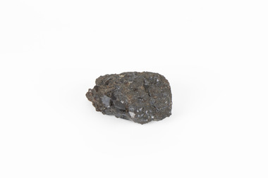 The Beechworth Burke Museum
Geological specimen - Garnet crystals in galena, Unknown
Majority of Galena in Australia is found in hydrothermal deposits emplaced around 1680 million years ago which have been heavily metamorphosed. Galena is the natural mineral form of lead sulfaide. It occurs generally as fine to large crystals due to syntectonic remobilization at low temperatures and moves to a suitable location. The colour is a shining lead and silvery gray with high specific gravity between 7.2 and 7.6 gms/cm3 and contains 86.6 lead sulfaide in its purest form. Its cyrstal system is cubic with perfect cleavages, and contract penetration and lamellar twinning. This particular specimen is from the Broken Hill mine, it is one of the largest lead mines located in Western New South Wales and still has ore reserves amounting to 20.9 million tonnes of ore grading of 7.4% lead, 9.4% zinc, and 61.5 million oz of Silver. Throughout its history, it has produced over 200 million tonnes of ore throughout its 127 years of mining history dating back to 1885. Galena mineral ore found in Australia is considered rare, as it is only currently found in the Broken Hill Mine of Western New South Wales. It represents heritage value through the systematic collecting of the geological surveyers in Victoria and Australia during the early to late 19th Century. The fact that it is only found in one mining area of Australia, shows that this specimen is rare for examples of Australian Galena. This mineral specimen is one part to a larger collection, aquistion, and distribution of Garnet in Galena around Australia and parts of the world and donated to the Burke Museum between 1860-1880. While this specimen was not found by the Victorian Geological Survey, it shows the historical need for mapping geological areas around the Gold Rush region to further identify areas of precious metal and gem aquisition. Additionally, collecting these specimens was an important part of mapping the scientific make up of the earth's surface. Many were sent to institutions for further contribution to research and scientific knowledge of the specimens. A solid coin-sized lead and zinc sulphaide and zinc silicate ore mineral in shades of black and red with shiny black points. GARNET CRYSTALS in / GALENA (lead sulphide), / SPALERITE (zinc sulphide), / WILLEMITE (zinc silicate) ore. / Locality: Broken Hill, NSWburke museum, #beechworth, indigo shire, beechworth museum, geological, geological specimen, mineral, galena, galena quartz, broken hill mine, broken hill, nsw -
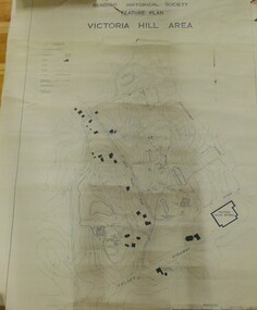 Bendigo Historical Society Inc.
Map - VICTORIA HILL AREA
Contour plan of the Victoria Hill area, with all of the historical features marked and namedCompiled by AHQ Survey Regt. CMF increment May 1971map, reserves, mining, bendigo goldfield, victoria hill -
 Bendigo Historical Society Inc.
Map - FORTUNA HUSTLER'S MINE - PLAN OF FORTUNA HUSTLER'S MINE
Map and plan of the Fortuna Hustler's Mine on the Hustler's Line of Reefs. Bulletin No 33, Plate No 1. Plan gives depth of the different levels. Bendigo Railway Station is on the map and also a number of the streets. Carpenter Street is called Cemetery Road. Also on the Hustler's Line of Reef is the Summer Hill Shaft. Shown is the Hustler's Royal Reserve No 2 Lease. Map has the Geological Survey of Victoria crest. It is signed by H Whit ? an Underground Survey Office Bendigo, September 1913. map, fortuna hustler's mine, hustler's royal reserve no 2 lease, summer hill shaft, hustler's line of reef -
 Bendigo Historical Society Inc.
Map - HUSTLERS LINE OF REEFS - LONGITUDINAL SECTION THROUGH THE SADDLE REEFS
Drawing with Longitudinal Section through the Saddle Reefs along portion of Hustler's Line of Reefs, Bendigo. Map shows the depth of the mines, reef numbers and Datum 700 ft above sea level. North and South is also noted on the map. Map signed by H. S, Whitelaw, Underground Survey Office, Bendigo, September 1913. Bulletin No 33, Plate No XXXIV. Bendigo Creek, Ironbark Creek and Long Gully are also noted. Mines are: Fortuna Hustlers, Hustler's Royal Reserve No 2 Main Shaft, Hustler's Royal Reserve No 2 Park Shaft, Royal Hustler's, Imperial Hustler's, Extended Hustler's Freehold, Great Extended Hustler's Tribute (Pups), Old Shaft, Great Extended Hustler's Reef No 2, Great Extended Hustler's Main Shaft, Old Shaft, Hustler's Reef, Hustler's Reef No 1, Comet, K. K., United Hustler's & Redan, Old Shaft and Hustler's Consols. Has Geological Survey of Victoria Crest and underneath is: H. Herman, Director, W. Dickson, Secretary for Mines, The Hon. J Drysdale Brown M L C. Minister of Mines.Geological Survey of Victoria Crestmining, hustler's reef maps, hustlers line of reefs, bendigo creek, royal hustler's, imperial hustler's, extended hustler's freehold, great extended hustler's tribute (pups), great extended hustler's reef no 2, great extended hustler's main shaft, hustler's reef, hustler's reef no 1, united hustler's & redan, old shaft and hustler's consols.h s whitelaw, underground survey office bendigo september 1913 -
 Bendigo Historical Society Inc.
Document - MARKS COLLECTION: PARISH PLAN OF WHITE HILLS
Sepia coloured map showing allotments in Parish of Sandhurst (White Hills) Written on LH side of map town and Suburban Lots White Hills Parish of Sandhurst. Scale is shown in chains. Surveyed by Horage Walker. Photo lithographed at the Department of Lands & Survey, Melbourne by J.Noone, Price 1/-. 6th. January 1865. Map shows Race Course Reserve at top of sheet, Municipal boundary is marked on LH side. Comments re vegetation throughout map. For example, poor soil timbered with Box scrub.on the back--Plan of Land White Hills Sandhurstbendigo, planning, white hills parish map, horage walker, j noone, department of lands and survey, -
 Bendigo Historical Society Inc.
Map - HUSTLER'S ROYAL RESERVE NO 2 CO. - LONGITUDINAL SECTION OF THE HUSTLER'S ROYAL RESERVE NO 2 CO
Longitudinal Section of the Hustler's Royal Reserve No 2 Co. on the Hustler's Line of Reef Bulletin No 33, Plate No VIII. Note - Plates 4, 8, 13, 20, 26 & 31 form a Longitudinal Section from Fortuna Hustler's to Hustler's Consols Mine. Mines mentioned are the Hustler's Royal Reserve No 2 Main Shaft, Hustler's Royal Reserve No 2 Park Shaft, Royal Hustler's, Imperial Hustler's, Great Extended Hustler's Freehold and the Great Extended. Section shows depth of levels, datum lines and height of sill above sea level yield in oz. of gold. Geological Survey of Victoria emblem. H. Herman, Director, W. Dickson, Secretary for Mines and The Hon. J. Drysdale Brown MLC, Minister for Mines and signed by H S Whitelaw, Underground Survey Office Bendigo, September 1913. mining, parish map, hustler's royal reserve no 2, royal hustler's, imperial hustler's, great extended hustler's freehold, great extended, geological survey of victoria, underground survey office bendigo, h s whitelaw, h herman, w dickson, the hon j drysdale brown -
 Bendigo Historical Society Inc.
Map - HUSTLER'S ROYAL RESERVE NO 2 MINE - PLAN OF THE HUSTLER'S ROYAL RESERVE NO 2 MINE
Plan of the Hustler's Royal Reserve No 2 Mine Bulletin No 33, Plate No V. Plan shows the Hustler's Royal Reserve No 2 (Main Shaft), Hustler's Royal Reserve No 2 (Park Shaft.), the Royal Hustler's, the Imperial Hustler's and the Extended Hustler's Freehold on the Hustler's Line of Reefs. Also mentioned is the Lightning Hill Line of Reefs. Map shows some of the levels, approximate boundary of lease and the boundary of Lease No 8892 and 8897. There are also street names and the locations of jail, lagoons, Post Office, Rosalind Park and the State School, High School and Continuation School. Geological Survey of Victoria emblem. H. Herman Director, W. Dickson, Secretary of Mines and The Hon. J. Drysdale Brown MLC, Minister of Mines. Signed by zh Whitdan, Underground Survey Office, Bendigo, September 1913.mining, parish map, hustler's royal reserve no 2 mine, royal hustler's, imperial hustler's, extended hustler's freehold, geological survey of victoria, h herman, w dickson, the hon j drysdale brown, h whitdan, hustler's line of reefs, lightning hill line of reefs -
 Bendigo Historical Society Inc.
Map - HUSTLER'S ROYAL RESERVE NO 2 MINE - PLAN OF THE HUSTLER'S ROYAL RESERVE NO 2 MINE
Plan of the Hustler's Royal Reserve No 2 Mine on the Hustler's Line of Reefs Bulletin No 33, Plate No VI. Boundary of Leases No 8898 and 8897 shown. Various levels shown and some geographical features. Geological Survey of Victoria emblem. H . Harman, Director, W. Dickson, Secretary for Mines and The Hon. J. Drysdale Brown, Minister of Mines and signed by H Whitdon, Underground Survey Office, Bendigo, September 1913. mining, parish map, hustler's royal reserve no 2 mine, hustler's line of reefs, geological survey of victoria, h herman, w dickson, the hon j drysdale brown mlc -
 Bendigo Historical Society Inc.
Map - HUSTLER'S ROYAL RESERVE NO 2 CO - TRANSVERSE SECTION OF THE HUSTLER'S ROYAL RESERVE NO 2 CO
Transverse Section of the Hustler's Royal Reserve No 2 Co Mine on the Hustler's Line of Reef Bendigo, Bulletin No 33, Plate No VII. Section shows the poppet legs and the sill of Shaft at 707.65 ft above sea level, depth of levels, stone encountered and geological features. Geological Survey of Victoria emblem. H. Herman Director, W. Dickson Secretary of Mines and The Hon. J. Drysdale Brown MLC, Minister of Mines. Signed by H S Whitelaw, Underground Survey Office Bendigo, September 1913. mining, parish map, hustler's royal reserve no 2 co, h s whitelaw, undergrou;nd survey office bendigo, geological survey of victoria, h herman, w dickson, the hon. j drysdale brown mlc -
 Bendigo Historical Society Inc.
Map - HUSTLER'S ROYAL RESERVE NO 2 (PARK SHAFT.) - TRANSVERSE SECTION OF THE HUSTLER'S ROYAL RESERVE NO 2
Transverse section of the Hustler's Royal Reserve, No 2 (Park Shaft.) on the Hustler's Line of Reef. Bulletin No 33, Plate No IX. Section shows poppet legs and sill of shaft at 755.70 ft above sea level, depth of levels, type of stone encountered including lava and geological features. Geological Survey of Victoria emblem and beneath it H. Herman, Director, W. Dickson, Secretary of Mines and The Hon. J. Drysdale Brown MLC Minister of Mines and signed by H S Whitelaw, Underground Survey Office, Bendigo September 1913.mining, parish map, hustler's royal reserve no 2 (park shaft.), h s whitelaw, underground survey office bendigo, geological survey of victoria, h herman, w dickson, the hon j drysdale brown mlc, hustler's line of reef -
Stawell Historical Society Inc
Map, Department of Lands & Survey J. Noone, Township of Heatherlie. Parish of Baroka. County of Borung 1888, 1888
Stawell & Grampians Freestone Quarry Company Railway Reserve. Cross & masons Quarry Site. Mamnager'sHouse, Stead's boarding House Stawell and Grampians railwaySurveyed Township Showing Quarry and railway Reservephoto Lithographed at the Department of lands and Survey Melbourne By J Noone 15.6.88railway quarry -
 Federation University Historical Collection
Book, Final recommendations Ballarat Study Area Land Conservation Council, Victoria, 1982, 1982
Yellow soft covered report of 95 pages . The contents of the report include: Parks, reference areas, wildlife reserves, water production, hardwood production, softwood production, flora Reserves and Flora and Fauna reserves, bushland reserves, historic area and reserves, rivers and streams, Roadside conservation and Highway parks, Education areas and School Plantations, Lake Reserves, geological reserves, recreation, scenic reserves, agriculture, mineral and stone production, utilities and survey, township land, Uncommitted Land, military training, other reserves and public land. Maps include: The Study area 1: 250 000 Supplementary Mapsland conservation authority, ballarat, endowment plantations, pine plantations, langi ghiran state park, mount buangor state park, enfield state park, ballarat-creswick regional park, rossbridge, black lake, flax mill swamp, dereel lagoon, lake bolac, lake wongan, langi ghiran reservoir, gong gong reservoir, pincotts reservoir, beales reservoir, wilsons reservoir, moorabool reservoir, korweinguboora, korweinguborra reservoir, learmonth bores, sago hill, illabarook reservoir, ballarat water commission, dunneworthy, mount cole, mont lonarch, ben major, waterloo, trawalla, linton, ross creek, canadian, shepherds flat, lal lal, mount doran, raglan, chute, carngham, buninyong, watsons hill, enfield, cape clear, illabrook, rokewood junction, mount warrenheip, nerrina, jubilee, golden stream, australasian deep lead mine, happy valley school, piggoreet, berringa, bulldog, ballarat common, wildlife, water, timber, flora, rivers, geology, agriculture, warrenheip, biodiversity