Showing 4374 items
matching the avenue
-
 Lakes Entrance Historical Society
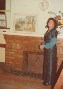
Photograph - Barkes Avenue Lakes Entrance Victoria, M Holding, 2006
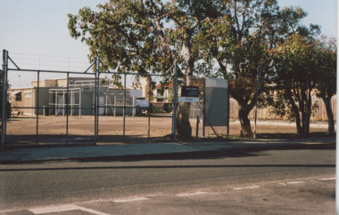
R S L Anzac site in Barkes Avenue showing small brick building and cleared grounds enclosed by security fence site of earlier guesthouse Lakes Entrance Victoria. Also a colour photograph of Telstra building enclosed by security fence and shrubs Barkes Avenue 04283.1 size 10 x 15 cmColour photograph of R S L Anzac site in Barkes Avenue showing small brick building and cleared grounds enclosed by security fence site of earlier guesthouse Lakes Entrance Victoria. Also a colour photograph of Telstra building enclosed by security fence and shrubs Barkes Avenue 04283.1 size 10 x 15 cmbusinesses, township, roads and streets -
 Bacchus Marsh & District Historical Society
Photograph, Osage Orange Avenue Taverner Street Bacchus Marsh
A.C. (Arthur Charles) Simon a pioneer orchardist in the Bacchus Marsh district planted this avenue of Osage orange trees in about 1883, creating an imposing entrance to his property from Taverner Street. Simon also believed that the trees on his orchard property would provide a protective shelter for his other plants. Osage orange trees (Maclura pomifera) are a small deciduous tree or large shrub, native to the south-central United States. It usually grows to about 8 to 15 metres high. The distinctive fruit, a multiple fruit that resembles an immature orange, is roughly spherical in shape, about 8 to 15 centimetres in diameter, and turns bright yellow-green in the autumn. A. C. Simon is believed to have imported the Osage orange seeds from America around the 1860s and later used them to plant the trees depicted in this image. The date of this image is not certain but it probably shows the trees around the 1900s or 1910s. The avenue of trees was known for many years in Bacchus Mars as 'Simons Avenue', and were featured in a Rose series postcard dating from around 1900-1920. The remnants of this avenue or grove of trees can be seen on some of the properties on the north side of Taverner Street Bacchus Marsh and along the Werribee River west of the FIsken Street bridge.The Bacchus Marsh Heritage Study of 1995 described the Osage Orange Tree avenue as being of regional historical significance as a landscaping practice, pioneering of its type, It was also described as of local significance as a well-known landmark due to it be being represented on widely distributed post cards which depicted scenes of Bacchus Marsh in the early part of the twentieth century. This early photographic image is evidence of this social and cultural significance.A black and white photograph print mounted on mounting board showing an avenue of Osage orange trees. trees, osage orange trees, simon family bacchus marsh, arthur charles simon 1833-1924, orchardists -
 Lakes Entrance Historical Society
Photograph - Memorial Carvings by John Brady, 1999
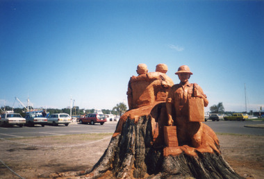
sculptures carved from WW1 Memorial Avenue cypress trees, by John Brady c1999 Lakes Entrance VictoriaColour photograph of sculptures carved from WW1 Memorial Avenue cypress trees, by John Brady c1999 Lakes Entrance Victoriaworld war 1914-1918, memorials -
 Lakes Entrance Historical Society
Photograph - Memorial Carvings by John Brady, 1999c
sculptures carved from WW1 Memorial Avenue cypress trees by John Brady c1999 Lakes Entrance VictoriaColour photograph of sculptures carved from WW1 Memorial Avenue cypress trees by John Brady c1999 Lakes Entrance Victoriaworld war 1914-1918, memorials -
 Ringwood and District Historical Society
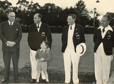
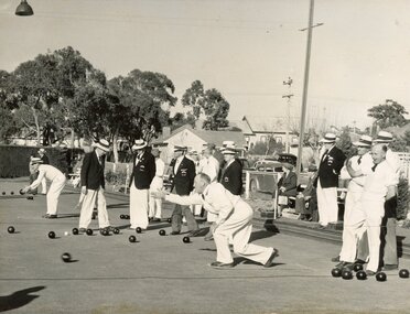
Photograph, Ringwood Bowls Club - Opening day in the 1954-55 season at the Miles Avenue green, with three Ringwood bowlers, a boy and an official looking man
... the Miles Avenue green, with three Ringwood bowlers, a boy and ...Black and white photograph"Written on back of photograph" Opening Day, 1954-55 -
 Ringwood and District Historical Society
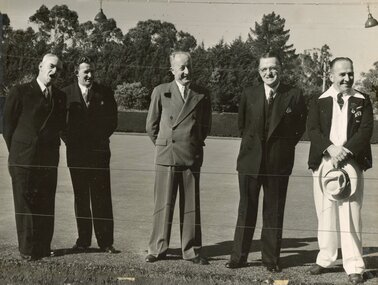
Photograph, Ringwood Bowls Club - Opening day in the 1953-54 season at the Miles Avenue green, with one Ringwood bowler and some officials
... the Miles Avenue green, with one Ringwood bowler and some ...Black and white photograph"Written on back of photograph" Opening Day, 1953-54. -
 Ringwood and District Historical Society
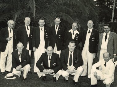
Photograph, Ringwood Bowls Club - Opening day in the 1953-54 season at the Miles Avenue green, with Ringwood bowlers and officials
... the Miles Avenue green, with Ringwood bowlers and officials. ...Black and white photograph"Written on back of photograph" Opening Day, 1953-54. -
 Ringwood and District Historical Society
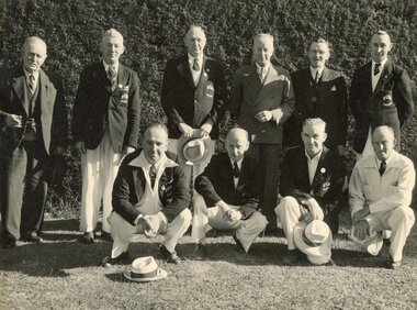
Photograph, Ringwood Bowls Club - Opening day in the 1954-55 season at the Miles Avenue green, showing club house, a large crowd and bowlers competing on the green
... the Miles Avenue green, showing club house, a large crowd and ...Black and white photograph"Written on back of photograph" Opening Day, 1954-55. -
 Ringwood and District Historical Society
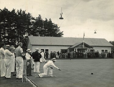
Photograph, Ringwood Bowls Club - Opening day in the 1953-54 season at the Miles Avenue green, looking East, showing bowlers competing on the green
... the Miles Avenue green, looking East, showing bowlers ...Black and white photograph"Written on back of photograph" Opening Day, 1953-54. -
 Ringwood and District Historical Society
Photograph, Ringwood Bowls Club - Opening day in the 1954-55 season at the Miles Avenue green, near a palm tree, showing a group of Ringwood bowlers
... the Miles Avenue green, near a palm tree, showing a group of ...Black and white photograph"Written on back of photograph" Opening Day, 1954-55. -
 Whitehorse Historical Society Inc.
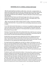
Document, Growing Up At 1 Vernal Avenue, 1947 - 1962
Childhood memories of Jenny Brash & her neighbours. She grew up at 1 Vernal Avenue, Mitcham and later Glenburnie Road.Childhood memories of Jenny Brash & her neighbours as she grew up at 1 Vernal Avenue, Mitcham and later Glenburnie Road.Childhood memories of Jenny Brash & her neighbours. She grew up at 1 Vernal Avenue, Mitcham and later Glenburnie Road.vernal avenue mitcham no1, brash jenny, orient avenue mitcham, wills jack, wills victor, glenburnie road mitcham no25 -
 Kew Historical Society Inc
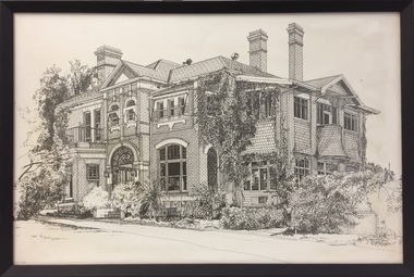
Print - 'Monnington', Adeney Avenue, Trompf, 1977
In the mid 1960s, the Monnington Special Education Centre was established at 15 Adeney Avenue as an offshoot to 'Glendonald' in Marshall Avenue. In 1988, the amalgamation of Princess Elizabeth Junior School for Deaf Children, the Monnington Centre and Carronbank School for Deaf Blind Students allowed the Victorian Government to sell each of the sites. Monnington [Adeney Avenue, Kew] reverted to private ownership, while Glendonald and Carronbank in Marshall Avenue were demolished and subdivided. The donor, Mr Murray Osler, was Principal of the Monnington Special Education Centre in Adeney Avenue (Kew) from 1976. This photo, and an accompanying drawing of 'Carronbank' are important primary resources for the history of the delivery of education to and for deaf-blind children in Victoria.Gift of Murray Osler, 2021This limited and numbered print [number 10/100], framed under perspex, is of Monnington in Adeney Avenue, Kew when it functioned as a Special Education Centre for deaf/blind children during the 1960s to the 1990s. . "Monnington Special Ed. Centre / 60s-90s / (Parent Guidance for Deaf/Blind Ch. / Adeney Ave, Kew / Murray Osler / Principal 76-80s"schools -- kew (vic.), mornington -- adeney avenue -
 Whitehorse Historical Society Inc.
Map, Parish of Nunawading, 1939
Plan of subdivision part of crown portions 81, 82 and 89,Plan of subdivision part of crown portions 81, 82 and 89, Parish of Nunawading, County of Bourke, Blackburn Wellington Avenue amended from Stanley RoadPlan of subdivision part of crown portions 81, 82 and 89, street names, parish of nunawading, blackburn road, blackburn, wellington avenue, blackburn, wolseley crescent, blackburn, gordon crescent, blackburn, clarke street, blackburn, central road, blackburn -
 Lakes Entrance Historical Society
Photograph - Ellen Parke , Lakes Entrance Artworks at first exhibition at RSL Hall, M Fish, 1980
Ellen Parke founder of Lakes Entrance Artworks at first exhibition at RSL Hall Barkes Avenue Lakes Entrance VictoriaColour photograph of Ellen Parke founder of Lakes Entrance Artworks at first exhibition at RSL Hall Barkes Avenue Lakes Entrance Victoriaarts, businesses, people -
 City of Kingston
Pamphlet - Colour, Ozone Hill Estate, Cheltenham, 1923
Sales plan for land in the suburb of Cheltenham, along both sides of Victori Avenue, off Weatherall Road.The developing urban area of Cheltenham within the City of Kingston. This land sale pamphlet illustrates the subdivision of land within the municipality and the changing demographic of the district as new houses are constructed.Colour pamphlet advertising for sale the Ozone Hill Estate, Cheltenham. Incorporates a map of the estate on either side of Victor Avenue, off Weatherall Road. Handwritten in blue ink on the subdivision map: 'Sold' is written on subdivisions 1-4, 8, 11, 13, 16-26, 28, 29, 33, 39-41 Handwritten in blue ink on the subdivision map: 'House being erected' is written on subdivisions 22 and 33. Handwrittten in grey pencil adjacent to subdivisions 21 and 22: Tennis / Courts / being / constructed / here Handwritten in grey pencil at bottom of page: Revised to 30/1/24 Handwritten in grey pencil on subdivision map: assumed land sale price is recorded on subdivisions 5-9, 9-10, 12, 14-15, 27, 30-32, 34-38. land sales, cheltenham, estate -
 Phillip Island and District Historical Society Inc.
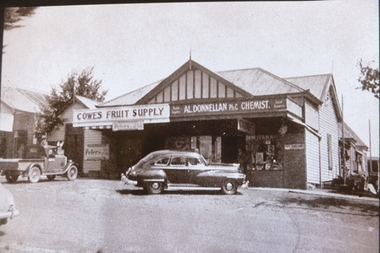
Photograph, 1940's
One of a collections of photographs purchased from Photo First, Thompson Avenue, Cowes, when it closed in June 2014. The store was previously the Cowes General Store. It changed ownership several times.Large Black & White photograph of Cowes Fruit Supply and a L Donnellan Ph Chemist in Thompson Avenue, Cowes. cowes general store, a. l. donnellan, photo first phillip island -
 Kew Historical Society Inc
Plan - Subdivision Plan, Windella-Darnley Subdivision, Studley Park, 1920s
Subdivision plans are historically important documents used as evidence of the growth of suburbs in Australia. They frequently provide information about when the land was sold on which a built structure was subsequently constructed as well as evidence relating to surveyors and real estate and financial agents. The numerous subdivision plans in the Kew Historical Society's collection represent working documents, ranging from the initial sketches made in planning a subdivision to printed plans on which auctioneers or agents listed the prices for which individual lots were sold. In a number of cases, the reverse of a subdivision plan in the collection includes a photograph of a house that was also for sale by the agent. These photographs provide significant heritage information relating house design and decoration, fencing and household gardens.Version 1 of two subdivision plans (the later one is MAP.0027) for the section of Studley Park Road near the Junction on the south side. Named in the subdivision are the mansions of Darley and Windella (now demolished). Before the subdivision of Darley and Windella, both houses fronted Studley Park Road. Both houses appear to be advertised as lots in the subdivision. Bisecting the subdivision is a street, Antrim Avenue that was never constructed. A street, which was subsequently constructed in this vicinity, was Merrion Place, which now runs between Studley Park Road and Highfield Grove. There are 14 proposed lots in this subdivision."Antrim Avenue. See over for new plan"subdivision plans - kew, studley park, windella, darnley, studley park road -- kew (vic.), merrion place -- kew (vic.), merrion grove -- kew (vic.), highbury grove -- kew (vic.) -
 Melton City Libraries
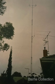
Photograph, Antenna for Mount Cotterill Fire Brigades Group, Unknown
Erected 1974, dismantled 2000s. The Headquarters was operated from the family home at Ferris road at its inception, and in 1974 to the Barrie home at First Avenue Melton South. A storage office and Radio Tower was erected in the yard. A connection phone line was linked to the home of Wayne and Lynn Sullivan who lived at the rear in Kurrajong Cr later became LY remote. Wayne later became Communications Officer and the Headquarters moved location to the Melton Fire Station. The Mount Cotterill Group encompassed the Rural Fire Brigades of Melton, Rockbank, Sydenham, Toolern Vale, Truganina, and Werribee and later Diggers Rest. In the stage of transition from H.F.( High Frequency) to Very High Frequency some radio sets were non CFA Tankers when the group was established. Antenna was at 19 First Avenue, Melton.emergency services -
Whitehorse Historical Society Inc.
Article, Multi-unit gets nod, 1991
Article on the development of seven housing unitsArticle on the development of seven housing units for young people in Ormond Avenue, Mitcham, following grant of an application made by Nunawading Council and Housing and Construction Victoria.Article on the development of seven housing unitshousing and construction victoria, city of nunawading, youth, houses, ormond avenue, mitcham -
Whitehorse Historical Society Inc.
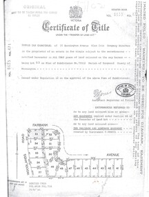
Document, Certificate of Title, 1924, 1934
Certificate of Title, Enoch CooperCertificate of Title, Enoch Cooper, Lot 55, Premier Avenue, Mitcham. Vol 4920 Fol 983886. Correspondence re rates, enforcement of charge, 1934.Certificate of Title, Enoch Cooperland titles, shire of blackburn and mitcham, rates, cooper, enoch, premier avenue, mitcham -
Whitehorse Historical Society Inc.
Document, 8 Hazelmere Avenue Mitcham, c1953
Plan and elevation for proposed brick veneer residencePlan and elevation for proposed brick veneer residence, 8 Hazelmere Avenue, Mitcham for O.M.T. Grant Esq. J. Chugg, 2 Morey Street, Burwood, Builder.Plan and elevation for proposed brick veneer residencegrant, max, hazelmere avenue, mitcham, no 8, j.r.., chugg -
 Lakes Entrance Historical Society
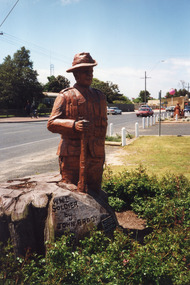
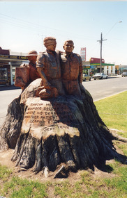
Photograph - Memorial Carvings by John Brady, first sculpture carved by John Brady, 1999
first sculpture carved from WW1 Memorial Avenue cypress trees of WW! Digger carved by John Brady , Lakes Entrance VictoriaColour photograph of first sculpture carved from WW1 Memorial Avenue cypress trees of WW! Digger carved by John Brady , Lakes Entrance Victoriaworld war 1914-1918, memorials -
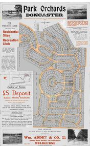 Ringwood and District Historical Society
Map, Park Orchards Land Sale Advertisement, Doncaster, Victoria, Circa 1926
Large linen backed map of the Park Orchards subdivision for private sale of residential sites and recreation club, highlighting local facilities, services and layout of the estate. Surveyors - Tuxen & Miller, 34 Queen Street, Melbourne. Agents - Wm Addey & Co., Pty Ltd., National Mutual Buildings, 395 Collins Street, Melbourne, Phone F3906. Terms £5 deposit balance monthly installments of £1 with the residue at the end of five years. Subdivision includes Alva Avenue, Arundel Road, Aviemore Avenue, Berringa Road, Bowmore Avenue, Brucedale Crescent, Brympton Avenue, Camber Avenue, Cawdor Avenue, Colin Avenue, Corriedale Crescent, Craithie Avenue, Daintree Avenue, Dalry Avenue, Dirlton Crescent, Drayton Crescent, Elgin Crescent, Enfield Avenue, Ennismore Crescent, Euston Avenue, Feversham Avenue, Frogmore Crescent, Gosford Crescent, Granard Avenue, Hopetoun Road, Hylton Avenue (later Knees Road), Jura Avenue, Park Road. -
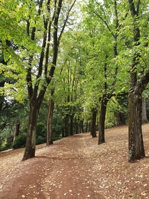 Ballarat Heritage Services
Photograph - Photograph - Colour, Clare Gervasoni, Wombat Botanic Gardens, Daylesford, 2019, 23/04/2019
The Daylesford Botanic Gardens are of historic, scientific (botanic), and aesthetic significance to the State of Victoria. The Daylesford Botanic Gardens are historically significant as a fine example of a regional botanic garden demonstrating the typical characteristics of a carriage drive, informal park layout, decorative structures and works such as the memorial tower, conservatory, rotunda, cascade and fernery, which contrasts with the open lawns planted with specimen trees, areas of intensive horticultural interest and close proximity to a township developed during the mid to late nineteenth century. The Daylesford Botanic Gardens are historically significant for the design input by noted landscape designer William Sangster, and for the survival of his 1884 plan, which is a rare example of a plan from this prolific garden designer. The Daylesford Botanic Gardens are of scientific (botanic) significance for the extensive conifer collection and cool climate plants. The Gardens contain an outstanding collection of conifers and other mature trees, many of which were donated by renowned botanist Ferdinand von Mueller. Significant trees include Pinus ponderosa (Western Yellow Pine), Pinus coulteri (Big Cone Pine), twoAbies nordmanniana (Caucasian Fir), Abies pinsapo, (Spanish Fir) and a Cedrus atlantica f. glauca(Blue Atlas Cedar), Pinus wallichiana (Bhutan Pine), Pinus pinaster (Maritime Pine), Sequoiadendron giganteum (Giant Redwood), (Monkey Puzzle) and Aesculus hippocastanum (Horse Chestnut), many the largest or finest examples in Victoria. Other outstanding trees include a Tilia cordata (Small-leaved European Linden), a row of Cupressus lusitanica (Mexican cypress), a Quercus robur (English Oak) planted in 1863, avenues of Dutch Elms and a rare Quercus leucotrichophora (Himalayan Oak). The Daylesford Botanic Gardens are of aesthetic significance as a rare example of a botanic garden spectacularly sited on an extinct volcanic cone which allows a panoramic view, aided by the 1938 Pioneers’ Memorial Tower, as well as vistas within and out of the gardens and from the township to the gardens. As the most prominent local landmark, the Garden’s vertical dominance in the landscape provides a dark contrast to the elms avenues, oaks and other deciduous species. (Heritage Victoria Register, 2025)An avenue of trees in the Wombat Hill Gardens. wombat botanical gardens, daylesford botanical gardens, daylesford, trees -
 Lakes Entrance Historical Society
Photograph - Memorial Carvings by John Brady, 1999
sculptures carved from WW1 Memorial Avenue cypress trees by John Brady 1998-1999, Lakes Entrance VictoriaColour photograph of sculptures carved from WW1 Memorial Avenue cypress trees by John Brady, Lakes Entrance Victoria c 1999 plus 2 other photographs world war 1914-1918, memorials -
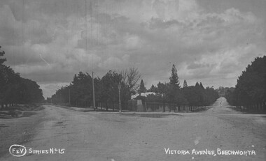 The Beechworth Burke Museum
Photograph
Taken in Beechworth, this photograph depicts the intersection between Victorian Avenue and Loch Street. Black and white photograph printed on a rectangular postcardObverse: F & V SERIES NO 15 VICTORIA AVENUE, BEECHWORTH (hand printed) Reverse: A03086 97.21.99 POST CARD R Pigram Cootamundra beechworth, victoria avenue, loch street, burke museum, photograph, postcard, intersection -
 Ringwood and District Historical Society
Document, Certificate of Title Vol 8633 Fol 471, Plan of Subdivision No. 73512, Parish of Ringwood, County of Mornington
A4 Title Search Enquiry printout dated 2003, with Subdivision Map including Fairbank Avenue and Woodlands Road, Heathmont, Vic.Issued under Regulation 12 on the approval of the above Plan of Subdivision. Derived from Vol 8618 Fol 718, 26/8/1966. Proprietor - Donald Ian Carmichael of 37 Dorrington Avenue Glen Iris. -
 City of Kingston
Pamphlet - Colour, Smith, Nicolson Pty. Ltd, Cheltenham Estate, c. 1890
Sales plan for land in the suburb of Cheltenham, bounded by Point Nepean Road and Swinden Avenue, including Evesham Road and Wallingford Street.The developing urban area of Cheltenham within the City of Kingston. This land sale pamphlet illustrates the subdivision of land within the municipality and the changing demographic of the district as new houses are constructed close to infrastructure.Colour pamphlet advertising for private sale Cheltenham Estate. Incorporates a map of the estate bordered by Point Nepean Road and Swinden Avenue, including Evesham Road, and Wallingford Street.Handwritten in red ink on subdivison 45: D / H Handwritten in red ink on subdivision 46: Anderson Handwritten in red ink on subdivisions 88, 87, 77 and 56: K / D Handwritten in red ink on subdivision 86: D / H Handwritten in red ink on subdivision 63 and 62: Hudson Handwritten in red ink on subdivision 59 [indecipherable] Handwritten in red ink on subdivision 58: aB Handwritten in red ink on subdivision 57: Lavosh Handwritten in grey pencil on subdivision 28, 26, 24, 67, 58, 49: B Handwritten in grey pencil on subdivisions 78 and 79: Paint Handwritten in purple pencil on subdivsion 114 and 86: B land sales, estate, cheltenham -
 Glen Eira City Council History and Heritage Collection
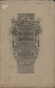
Booklet, D. W. Paterson Co. Pty. Ltd, "AVENUES OF HONOUR The Councils of the Municipalities of the CITY OF CAULFIELD TOWN OF BRIGHTON acting in conjunction PUBLIC DEMONSTRATION SAT 3rd AUG. 1918 AT 3oCLOCK SOUVENIR"
Souvenir Programme from the Councils of the Municipalities of the City of Caulfield and the Town of Brighton for a Public Demonstration to be held on Sat 3rd August 1918 at 3 o'clock for the proposed Avenues of Honour to be planted in memory of fallen WWI soldiers. One of two known copies, this copy has "Town Clerk" stamped in the upper corner, rhs.Commemorative booklet, grey cover with text printed on the grey textured paper and an image of four trees and a wreath. Image of a kookaburra on the back. Inside, 28 numbered pages with b/w text and photographic images including a transparent paper representation of the proposed Avenues of Honour on Brighton Road and Point Nepean Road. Souvenir programme for a Public Demonstration for the Avenues of Honour as detailed on the front. From Honour Roll Display 2019 interpretation panel - Brighton-Caulfield Avenue of Honour It is hard to imagine but a grand arboreal Avenue of Honour once lined parts of North Road, McMillan Street and Point Nepean Road (now Nepean Highway). The Avenue of Honour was a distinctly Australian phenomenon with hundreds being constructed throughout Australia during and following World War One, most of these in Victoria. Consisting of tree lined streets with each tree representing a solider, the Avenue of Honour signalled a more egalitarian approach to commemoration where rank was not a consideration. Arguably the most famous Avenue of Honour in Victoria still exists at Ballarat. Stretching for nearly 22 kilometres, the entrance to the Avenue is marked by the imposing Arch of Victory. Smaller in scale, the Brighton-Caulfield Avenue of Honour was dedicated to the ‘memory of (Brighton and Caulfield’s) kith and kin who came from (the) district and who died in the Great War’. A joint project between the neighbouring Councils, the idea was first reported in The Argus on 1 July 1918. Plans moved along quickly and on 3 August 1918 the Governor of Victoria Arthur Stanley planted the first Australian flowering gum. The next of kin were then invited to plant trees for lost sons, brothers, uncles, nephews and husbands. In all, over 400 trees were planted. Intensely personal, the Avenue also acted as a focus of grief and remembrance for the wider community. For many years, the annual civic Anzac Day service was held at the Avenue on Point Nepean Road, near Glen Huntly Road, Elsternwick. The service was moved to Caulfield Park upon the completion of the Cenotaph in 1930. Due to road widening and disease the last original tree was replaced in the 1980s, however a plaque in Caulfield Park records the Avenue’s plantation. Inkstamp upper corner rhs: "TOWN CLERK" -
 Lakes Entrance Historical Society
Photograph - Memorial Carvings by John Brady, 1999c
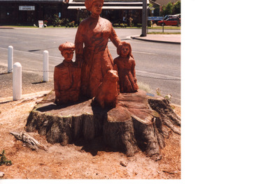
most eastly of the three sculputres carved from WWI Memorial Avenue adjacent to the western boat Harbour Esplande Lakes Entrance Victoria Carved by chainsaw artist John Brady, September 1998.Colour photograph of the most eastly of the three sculputres carved from WWI Memorial Avenue adjustant to the western Hharbour Esplande Lakes Entrance Victoriaworld war 1914-1918, memorials