Showing 276 items matching "the loddon"
-
 Bendigo Military Museum
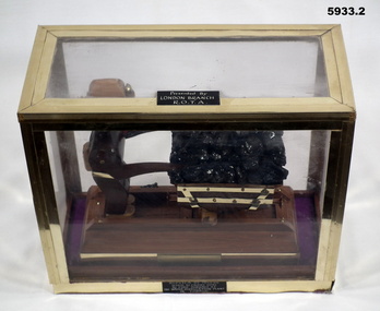
Souvenir - SOUVENIR, COAL TRUCK, Post WW2
Coal was used to run the Water Distillation Plant in Tobruk during the Seige. On plaque, "London Branch", This may actually be "Loddon Branch". Item in the collection re Ron Bollard VX14150, refer cat No 5919P for his service details..1) Base with model depiction of a soldier pushing a coal truck loaded, wood, metal, construction, each side has a brass plaque on the coal truck base, the lower base has a black plaque on..1) Brass plaque, "9th Division 1941", "replica of trucks used to carry coal". .2) On lid, "Donated by LONDON Branch R.O.T.A"sovenir, model, tobruk, coal -
 Bendigo Military Museum
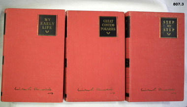
Book - SET OF BOOKS, Odhams Press Limited, 1) My Early Life; .2) Great Contempories; .3) Step by Step, 1) -.3) Reprinted 1948
3. Volume set. Autobiography by Winston Churchill; red cloth covers. Titles in gold on black panels. .1) 373 pages, plain, illustrated, black and white photographs. .2) 309 pages, plain, illustrated, black and white photographs. .3) 350 pages, plain, illustrated, map..1) - .3) Handwritten blue ink on title page "J.M. Coglin Feb 16th, 1949". .2) Handwritten blue ink on title page "Ralph ????ling Strathmore Loddon Vale"books, biography, military history -
 Bendigo Military Museum
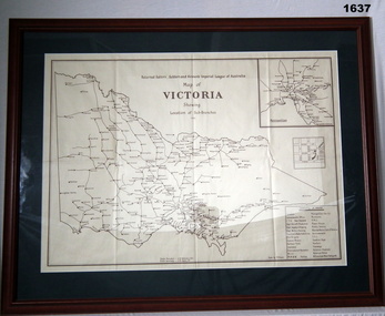
Map - RSL'S VICTORIA, FRAMED, Bethany Gallery, 1949
This map originally came via Mitiamo East Loddon RSL who when they closed their Sub branch the map and their records were handed to the Bendigo RSL for safe keeping. It was framed and was hanging in the Office of the SMI until the renovations to the building in 2016.Dark green mount with brown wooden frame. Brown printing on cream paper. Perspex covering map.Top centre of map: “Returned Sailors, Soldiers & Airmen's Imperial League of Australia Map of Victoria showing Sub Branches 1949” Stamped on rear: Bethany Gallery. Traditionally a touch of Excellence Terry ? Jarvis, 116 Bridge Street, Bendigo Vic 3550 Ph (03) 5442 4771brsl, smirsl, map rsl's -
 Bendigo Historical Society Inc.
Map - JANIEMBER WEST : COUNTY OF BENDIGO, September 1955
Map. Janiember West, County of Bendigo, Powlett, Janiember East, Jarklan, Kinypanial, River Loddon, Kelsh's Lagoon. By authority W.M. Houston, Government Printer. Drawn and reproduced at the Department of Lands and Survey, Melbourne. Price 2/-.September 1955. (number 64 in map cupboard 1)W.M. Houston, Government Printermap, bendigo, janiember west -
Bendigo Historical Society Inc.
Map - JANIEMBER WEST : COUNTY OF BENDIGO, September 1955
Map. Janiember West, County of Bendigo. Loddon River, Janiember East, Powlett, Kinypanial, Jarklan. Welsh's Lagoon. By authority W.M. Houston, Government Printer, Melbourne. Drawn and reproduced at the Department of Lands and Survey, Melbourne, September 1955, Price 5/-. (number 66 in map cupboard 1)W.M. Houston, Government Printer, Melbourne.map, bendigo, janiember west -
 Bendigo Historical Society Inc.
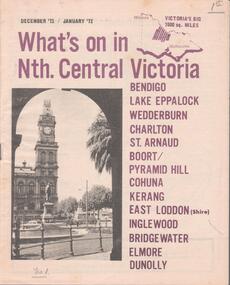
Document - WHAT'S ON IN NTH CENTRAL VICTORIA
Four issues of the ''What's on in Nth. Central Victoria'' advertising booklets. The booklets cover the area of Bendigo, Lake Eppalock, Weddeburn, Charlton, St. Arnaud, Boort, Pyramid Hill, Cohuna, Kerang, East Loddon, Inglewood, Bridgewater, Elmore and Dunolly. Published from December 1971 to May 1972 -
Bendigo Historical Society Inc.
Map - TARNAGULLA : COUNTY OF BENDIGO, 1959
Map. Tarnagulla, County of Bendigo, Sheet 3, Kingower, Glenalbyn, Inglewood, Loddon River, Derby, Gladstone. Drawn and reproduced at the Department of Lands and Survey, Melbourne, 1959. Price 5/- per sheet. By authority A.C. Brooks, Government Printer, Melbourne. (number 35 in map cupboard 1)A.C. Brooks Government Printer, Melbourne.map, bendigo, tarnagulla -
Bendigo Historical Society Inc.
Map - BRIDGEWATER : COUNTY OF BENDIGO, 6-10-27
Map. Bridgewater, County of Bendigo, Inglewood, Salisbury, Derby, Leichardt, Yarraberb, Yarrayne, Bullock Creek, Loddon River, Sandhurst and Inglewood Railway. Photo-Lithographed at the Department of Lands and Survey Melbourne by W.J. Butson, 6-10-27. Price 1/-. (number 53 in map cupboard 1)W.J. Butsonmap, bendigo, bridgewater -
 Victorian Aboriginal Corporation for Languages
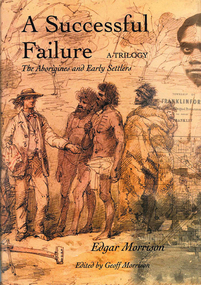
Book, Edgar Morrison, A successful failure, a trilogy : the Aborigines and early settlers, 2002
Tells of the Aboriginal Protectorate System in Colonial Victoria during the period 1838 to 1852. The system was designed to be a buffer between the original inhabitants and the influx of white squatters. That the system failed is of little wonder. This story traces the times of Edward Stone Parker, Assistant Aboriginal Protector in the Loddon region of Victoria.maps, b&w photograph, colour photographs -
 Bendigo Historical Society Inc.
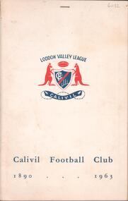
Book - CALIVIL FOOTBALL CLUB 1890-1963, 1964
41 page soft cover booklet 'Calivil Football Club 1890-1963' A history of this football club in the Loddon Valley League with B&W team photos. Edited by H.A .Lister, past player, Captain-Coach, Secretary and Presidemt of the club. Death notice of H.A.Lister stapled inside front cover.H A Lister -
Bendigo Historical Society Inc.
Map - DERBY : COUNTY OF BENDIGO, 1959
Map. Derby, County of Bendigo, Inglewood, Tarnagulla, Woodstock, Leichardt, Bridgewater, Loddon River, Bendigo Railway, Calder Highway, Maldon to Bridgewater Road.By authority A.C. Brooks, Government Printer, Melbourne. Drawn and reproduced at the Department of Lands and Survey, Melbourne, 1959. Price 5/-. (number 59 in map cupboard 1)A.C. Brooks, Government Printer, Melbourne.map, bendigo, derby -
Bendigo Historical Society Inc.
Map - SALISBURY WEST : COUNTY OF BENDIGO, 3-3-1944
Map. Salisbury, County of Bendigo, County of Gladstone, Powlett, Yarrayne, Bridgewater, Inglewood, River Loddon, Bullabul Creek, Glenalbyn, Kurting. By Authority H.E. Daw, Government Printer, Melbourne. Drawn and reproduced at the Department of Lands and Survey, Melbourne., 3-3-1944. Price 5/-. (number 94 in map cupboard 1)H.E. Daw, Government Printer, Melbourne.map, bendigo, salisbury west -
Bendigo Historical Society Inc.
Tool - INDIGENOUS STONE TOOL COLLECTION: DARK GREY STONE AXE HEAD
Dark grey to black stone axe head. Finely shaped and smoothed with knapped edge on longer end. Sides are bevelled off. This axe is markedly different to other artefacts in this collection. No provenance but was in a collection of stone tools found in the Axedale, Strathfieldsaye and Loddon regions. Further research required, could be Mt. William greenstone. -
 Ballarat Heritage Services
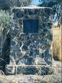
Photograph - Photograph - Colour, Clare Gervasoni, Edward Stone Parker Memorial, Franklinford, 25/10/2015
Franklinford is in the 'shadow' of Mt Franklin, the site of Edward Stone Parker's Aboriginal Protectorate.Photograph of a stone memorial cairn to Edward Stone Parker, Protector of Aborigines. "Edward Stone Parker 1802-1865 Regional Pioneer, Protector of Aborigines Established the Loddon Aboriginal Station Homestead, Church and School near this site in 1841. His devoted service remains a challenge and an Inspiration. April 1965."edward stone parker, protector of aboriginies, aboriginal protectorate, loddon aboriginal protectorate, franklinford aboriginal protectorate, franklinford -
 Tarnagulla History Archive
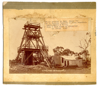
South Gippsland Syndicate mine, Nick o' Time Lead, 1905, 1905
John James is standing on the staircase. He erected the poppet head and buildings on behalf of the syndicate. He was an experienced mine manager and highly regarded local engineer. The mine was located close to and on the western side of the Newbridge-Eddington Road, approximately one kilometer north of the Poseidon Road intersection. The remains of a once-prominent mullock head can be seen on the site. Paper label stuck onto image reads 'Plant erected by John James for Mr J. Jackson (seated - J. James, standing). Lower Hewett & Young. Nick O Time South of Newbridge ON LODDON 1905'. -
Bendigo Historical Society Inc.
Map - SALISBURY WEST : COUNTY OF BENDIGO, 24-6-24
Map. Salisbury, County of Bendigo, County of Gladstone, Powlett, Yarrayne, Bridgewater, Inglewood, Glenalbyn, Kurting, River Loddon, Bulabul Creek. By authority A.J. Mullett, Government Printer, Melbourne. Photo-Lithographed at the Department of Lands and Survey, Melbourne by W.J. Butson, 24-6-24. Price 1/-. (number 116 in map cupboard 1)A.J. Mullett, Government Printer, Melbourne.map, bendigo, salisbury west -
 Bendigo Historical Society Inc.
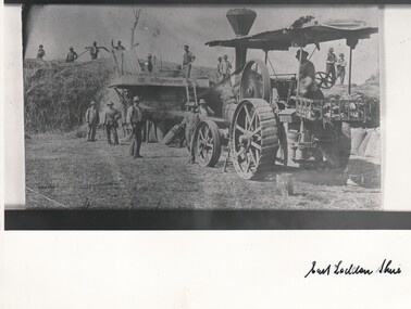
Photograph - HARRY BIGGS COLLECTION: D. COGHILL AND SONS
Copy of a photograph of a group of men using a threshing machine, the name D. Coghill and sons is written on the machine. There is one man seated on the traction engine and six other men standing. There is a large pile of hay at the rear of the machine with ten men standing on the stack, most of the men are holding pitchforks. East Loddon Shire is written on the base of the phototopic, farming, threshing, traction engine, threshing machine, d. coghill and sons -
 Bendigo Historical Society Inc.
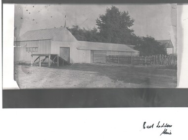
Photograph - HARRY BIGGS COLLECTION: SHEARING SHED
B&W Photograph of a shearing shed, with a wooden extension, there are sheep yards off to the side of the extension. There is a weather vane attached to the gable, there are trees in the background. Another shed with a weather vane can be seen behind the trees. A ramp extends upwards from a door in the end of the shed. The words 'East Loddon Shire' are written at the bottom of the Photoplace, building, shearing shed, east loddon shire, shearing shed -
 Bendigo Historical Society Inc.
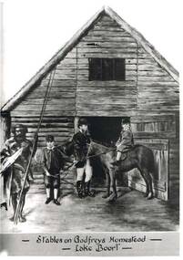
Photograph - HARRY BIGGS: STABLES ON GODGREYS HOMESTEAD
Black and white photo of Mr Henry Godfrey and his sons along with Prince Charlie of the Jajoweroung or Loddon Tribe. The group are standing in front of wooden stables with a window in the roof above the open door. One son is on a horse and the other is holding the reins. The boys are both wearing hats and are dressed in stockings and breeches. Mr Godfrey is the background wearing a hat riding boots, breeches and a 3/4 coat. In the front to the left is Prince Charlie holding two spears and is in native costume. At the bottom of the photo written in black ink is: Stables on Godfreys Homestead - Lake Boort - On the back of the Photo is written in clue Ink "Stables on Godfrey's Boort Homestead, Lake Boort, November 1863. W. Henry Godfrey and his sons, with "Prince Charlie" of the jajoweroung or Loddon Tribe.photo, group, godfreys homestead, stables on godfreys homestead, lake boort, prince charlie, henry godfrey and his sons. -
 Bendigo Historical Society Inc.
Document - MANUSCRIPT: THE ''HISTORY OF OLD INGLEWOOD'' (NO ACTUAL TITLE)
Thirty paged manuscript re the ''History of old Inglewood'' (No actual title or stated author. The 'Preface' (last page) states that in 1961 the town would celebrate its centenary and, also, that it lost its official identity (amalgamation with the Shire of Korong). Comprises:Introduction; Aboriginal life and early history of interaction with settlers; Major Mitchell exploration in area (''Yarrayne'' as name given for the Loddon; Mt Korong - aboriginal ''Barrabungale''); Pioneers on the Loddon - land tenure (Order of Council 1847), ref to Simson (Donald Campbell; Hector Norman); Charlotte Plains (run); John Catto (of Loddon) and John Catto (of Berlin); William Allen; Alexander Moffat Allen; Mr Sellars; 1852 gold rush to Mt Korong (surface); 1859 discovery of gold at Inglewood ( A J Thompson, T Thompson, T Harvey); detail of gold mining in Inglewood; Borough of Inglewood (1863); growth of the town - hotels, banks, newspapers; 1863 fire in township; fire brigade at Inglewood; selection of land; the ''Land Convention''; the ''Duffy Act''; land selection; 'modern' developments in Inglewood(rail, gas); Jack Donaldson - runner 100 yds sprint title; armed services involvement of Inglewood (WW1 & WW2); government departments.inglewood, history, early history, lodden, mt korong, donald campbell, hector norman, inglewood fire brigade, duffy act, jack donaldson, alexander moffat, john catto, major mitchell, ww1, ww2. aboriginal life, order of council 1947. -
Bendigo Historical Society Inc.
Map - NERRING : COUNTY OF BENDIGO, August 1952
Map. Nerring, County of Bendigo, Yarraberb, Leichardt, Marong, Sandhurst, Huntly, Neilborough, Bendigo and Swan Hill Railway, Bendigo and Kulwin Railway, Loddon Valley Highway. By authority J.J. Gourley, Government Printer, Melbourne. Drawn and reproduced at the Department of Lands and Survey, Melbourne, Victoria. August 1952. Price $1.00. (number 76 in map cupboard 1)J.J. Gourley, Government Printer, Melbourne.map, bendigo, nerring -
Bendigo Historical Society Inc.
Map - POWLETT : COUNTY OF BENDIGO, 2-12-15
Map. Powlett, County of Bendigo, County of Gladstone, Janiember West, Janiember East, Yarrayne, Salisbury West, Kurting, Korong, River Loddon. By Authority Albert J. Mullett, Government Printer, Melbourne. Photographed at the Department of Lands and Survey, Melbourne by W. J. Butson.2-12-15. Price 1/-. (number 119 in map cupboard 1)Albert J. Mullett, Government Printermap, bendigo, powlett -
Bendigo Historical Society Inc.
Tool - INDIGENOUS STONE TOOL COLLECTION: AXEDALE AREA STONE AXE HEAD
Dark grey, very hard stone, knapped at one end to sharp edge. Number '8' stuck on stone with tape. Interpretive sign with stone reads ' Stone age implements, exhibits 6 - 10, all found near Axedale, Victoria. Stone axe heads, compare these with a selection of axe heads from the banks of the Loddon, Exhibits 11 - 13' -
 Bendigo Historical Society Inc.
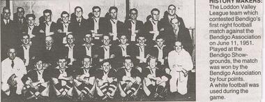
Newspaper - JENNY FOLEY COLLECTION: HISTORY MAKERS
BHS CollectionBendigo Advertiser ''The way we were'' from Monday, December 6, 2004. History makers: the Loddon Valley league team which contested Bendigo's first night football match against the Bendigo Association on June 11, 1951. Played at the Bendigo Showgrounds, the match was won by the Bendigo Association by four points. A white football was used during the game.newspaper, bendigo advertiser, the way we were -
 Bendigo Historical Society Inc.
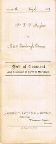
Document - CONNELLY, TATCHELL, DUNLOP COLLECTION: DOCUMENT
Deed of Covenant and Extension of Term of Mortgage, dated 11 August 1899 between Thomas Francis Moylan of Loddon Vale and William Fairclough, Bank of Victoria London and Gilbert Wilson Brown, Mathoura Raod, Toorak extend the Mortgage until the 16 August 1902. Orange Victoria One Penny Duty Stamp attached. Small red seal next to signature.business, legal, connelly & tatchell, connelly & tatchell collection - document, deed of covenant and extension of term of mortgage, connelly tatchell & dunlop, thomas francis moylan, william fairclough, bank of victoria london, gilbert wilson brown, davidson, j b young -
Bendigo Historical Society Inc.
Map - JANIEMBER EAST : COUNTY OF BENDIGO, 15-1-34
Map. Janiember East, County of Bendigo, Jarklan, Pompapiel, Yarrayne, Powlet, Janiember West, Serpentine Creek, Caney's Blind Creek Long Plain Creek, Loddon River. By authority : H.J. Green, Govt. Printer, Melbourne. Drawn and reproduced at the Department of Lands and Survey, Melbourne, Victoria. Price 2/-. 15-1-34. (number 45 in map cupboard 1)H.J. Green, Govt. Printer, Melbourne.map, bendigo, janiember east -
Bendigo Historical Society Inc.
Tool - INDIGENOUS STONE TOOL COLLECTION: AXE HEAD OR SCRAPER, AXEDALE AREA
Brown stone, has slight granite appearance. Short edge knapped to provide a sharp edge. Number 10 stuck on stone with tape. Interpretive sign with item reads' Stone Age Implements, exhibits 6 - 10, all found near Axedale, Victoria. Stone Axe heads ( compare these with a selection of Axe Heads from the banks of the Loddon, Exhibits 11 - 15) -
 Bendigo Historical Society Inc.
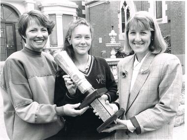
Photograph - BENDIGO ADVERTISER COLLECTION: SPORTS STAR AWARDS PRESENTATIONS, 9/11/93
Black and white photograph, multiple people, photograph of Helen Ward, Sally Reynolds and Maxine Crouch in front of the Bendigo CCB Catherine McAuley College Bendigo Advertiser description: 9/11/93 ALP SPORTS AWARDS WINNERS Helen Ward 8 Loddon Valley Netball League Sally Reynolds, 16, Tumbler Maxine Crouch Pres of BGO Sportswomens Associationrecreations, sports, awards -
NMIT (Northern Melbourne Institute of TAFE)
Book: Furniture and equipment layouts for TAFE colleges Victoria. 1981
A4 size loose pages published by the Public Works Department and the Education Department Victoria in 1981. The contents cover the following Colleges: Moorabin, Dandenong, Collingwood, Newport, Box Hill, Sunraysia, Yallourn, Footscray, RMIT, Preston, School of Mines & Industries Ballarat, McMillan Rural Studies, Loddon Valley Bendigo, Wangaratta and Latrobe Street Complex. Plans and diagrams included.manuals, tafe colleges, preston technical college, collingwood tedhnical college, nmit -
 Ballarat Heritage Services
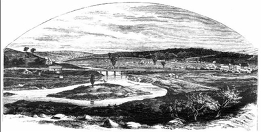
Photograph - Image, Guildford, Victoria, 1867
Black and white image of Guildford, near Castlemaine, VictoriaGUILDFORD Is a small township situated at the junction of Campbell's Creek and the Loddon. It is about seven miles from Castlemaine, on the road from that town to Ballaarat and Daylesford. The land near the Loddon is very rich, and as a large number both of theoretical and practical miners believe that a rich goldfield underlies the surface basalt, there is every probability of Guildford being ere an important goldfield. A large area of land in the neighbourhood has been already worked, principaIy by Chinamen, who until very recently mustered in great force in the locality. (Illustrated Adelaide Post, 23 March 1867)guildford, loddon river