Showing 2753 items matching "towers"
-
 Stawell Historical Society Inc
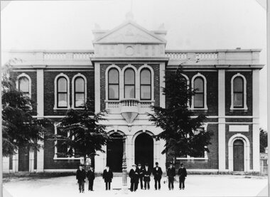
Photograph, Stawell Town Hall c1910
Stawell Town Hall without clock tower. C1910Town Hall with suited men probably important out front No Clock tower. Large trees in front of building.stawell -
 Port Fairy Historical Society Museum and Archives
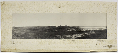
Photograph, Tower Hill Koroit, unknown
Panoramic mounted photograph of Tower Hill Volcano with lake.Interesting photograph of Tower Hill before extensive re-vegetation works carried out in the 1960s.Panoramic landscape black and white photograph of Tower Hill, Koroit. Mounted black and white photograph on card, rectangular.? Aberline, 26 Faversham R?, Canterbu? On back of card mount Fred Rogersvolcanoes, tower hill -
 Tatura Irrigation & Wartime Camps Museum
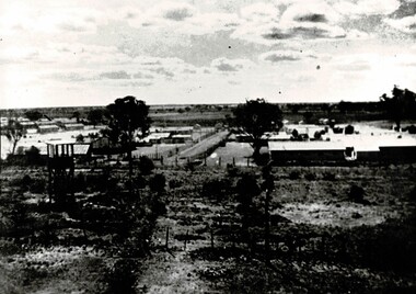
Photograph, Dhurringile, C. 1940
Imposing brick mansion with tower, built by James Winter 1877 .Photo shows enclosed barbed wire internment camp 1939/ POW camp for German officers and other ranks 1941 - 1945Brick two story mansion, with water tower on stand in foreground. -
 Tatura Irrigation & Wartime Camps Museum
Photograph, Camp 3 from water tower, 1947
Picture of Camp 3, B and C compounds, taken from the water tower by Vollmer family, 1947, prior to repatriation to Germany. Several other copies in file.Black and white photographs of huts surrounded by perimeter fences with guard tower in foreground.internment camps, pow's, camp 3, water tower camp 3 -
 Ballarat Heritage Services
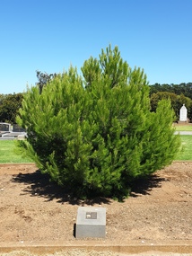
Photograph - Photograph - Colour, Clare Gervasoni, Aleppo Pine, Tower Hill Cemetery, 2019, 03/01/2019
The Tower Hill Cemetery is located near Koroit on the north side of the Princes Highway The, between Port Fairy and Warrnambool. The first burial at Tower Hill Cemetery took place in 1856. Over 150 years there has been over 8,000 burials. Around 45 percent of the burials are in unmarked graves. In 2023 this tree was no longer in existence, and a smaller tree was struggling in this site.Colour photographs of an Aleppo Pine planted in the Tower Hill Cemetery to mark the centenary of the landing at Galipolli.aleppo pine, anzac centenary, centenary, anniversary, tower hill cemetery, gallipoli -
 Wodonga & District Historical Society Inc
Photograph - Wodonga Water Tower, July 1984
THE WATER TOWER is a major landmark of High Street, Wodonga. It began operation from 1924 until it ceased operation in 1959. It stood unused for a decade until the lower section was modified and put to use as “ The Tower’s Cobbler’s Inn” in 1962. In 1972 Wodonga City Council proposed to demolish the Tower. Their suggestion received an unfavorable response from the city’s citizens, so the Tower still stands today. This image shows High Street and Hovell Street looking to the north The Civic Centre Theatre is on the right in Hovell Street. On the left in High Street is Tower Place on left. On the far left Repco which by 1998 became a Chinese restaurant and remains so in 2022.This photo is significant as it depicts a major building which has been used to represent the city of Wodonga in many souvenirs and publications over time.One of many photos of the Wodonga Water Tower in our collection. It is a large black and white image which has been mounted in a metal frame.wodonga water tower, wodonga city -
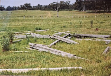 Tatura Irrigation & Wartime Camps Museum
Photograph, Arthur Knee, Guard tower ruins camp 13, 1989
Camp 13 guard observation tower beams (ruins) in paddock. Timber and wire fence mid distance.Camp 13, Camp Road, Murchison, Victoria. Timber beams, remnants of guard observation tower (foreground).camp 13, internment camp, murchison victoria, observation tower, ruins, guard tower ruins -
 St Kilda Historical Society
Photograph, Esplanade St Kilda
view from Luna Park tower black and white photograph, unmounted, good conditionMelbourne Suburbs St Kilda View of Esplanade St Kilda from Luna Park Tower, stamped National Library of Australia -
 Eltham District Historical Society Inc
Photograph, Shire of Eltham War Memorial, Memorial Park, Garden Hill, Eltham-Yarra Glen Road, Kangaroo Ground, c.1936, 1936c
On November 11th 1926 the Shire of Eltham War Memorial Tower at Kangaroo Ground was opened. It is regarded as one of Melbourne’s most outstanding lookout towers. It commands a magnificent 360 degree panorama from Kinglake across the Diamond Valley to Macedon and the You Yangs. It is built on a peak which was once a volcano, 237 metres above sea level. After World War one a memorial cairn was erected on the site, and in 1925 a committee of public-minded citizens began to plan for a tower. Many generous donations of material and money were forthcoming so that in 1926 the Governor General Lord Stonehaven was able to unveil the plaque before a crowd of 500 people There was some concern in the 1960s when the Forests Commission wanted to build a firespotters cabin on the top. At first R.S.L. branches opposed the idea, but it was realised that this use could combine with its use as a tourist attraction, and would ensure its maintenance for the future. Today the Kangaroo Ground tower provides one of the best views around Melbourne and is a fitting memorial to those who died in two world wars. From: Historic items for Diamond Valley Community Radio September 1990 (EDHS collection) On November 8th, 1951, the memorial was re-dedicated by the Governor of Victoria, Sir Dallas Brooks with the addition of the names of men from the Shire of Eltham who fell in the Second World War. Further wreaths were added subsequent to this image in time for the 2001 Reembrance Day service to commemorate the men from th shire who had fallen in the Malayan, Korean, Borneo and Vietnam campaigns. Sepia photograph showing two ladies standing in front of the towergarden hill, kangaroo ground, kangaroo ground memorial, memorial park, shire of eltham war memorial tower, war memorial -
 Ballarat Heritage Services
Photograph - Colour, Tower Hill, 2016, 31/12/2016
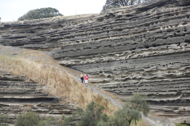
Tower Hill is a volcanic formation believed to have erupted about 32,000 years ago. Its formation is known as a "nested maar" and it is the largest example of its type in Victoria. During formation, molten lava pushed its way up through the Earth’s crust and encountered a layer of water-bearing rock. Violent explosions followed creating a shallow crater which later filled with water to form the lake. Further eruptions occurred in the centre of this crater, creating the islands and cone shaped hills. In 1892 Tower Hill became Victoria’s first National Park. In 1961, Tower Hill became a State Game Reserve under the then Fisheries and Wildlife Department and a major re-vegetation program began. (https://www.towerhill.org.au/index.php/about-reserve/history, accessed 23 December 2019)A number of photographs taken at Tower Hill, including the lakes, volcanic ash layer, and koala.tower hill, ash layer, volcano -
 Kew Historical Society Inc
Textile - Souvenir Textile, Souvenir of Palestine, c1939-45
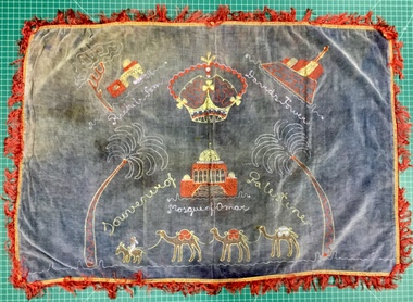
Souvenir probably bought by an Australian soldier in the 2nd A.I.F., and brought back to Australia as a souvenir.Rectangular blue faded to grey velveteen water damaged textile with a plain white cotton backing with a red fringe. The front of the textile is embroidered in red, yellow, blue and white chain stitch. It shows two palms flanking the Mosque of Omar lower centre with three camels and a man on a horse below, Rachel's Tomb with tree upper left and David's Tower upper right."Souvenir of Palestine"; "Rachels tomb"; "Mosque of Omar"; "David's Tower"second world war 1939-1945, table cover, palestine, 2nd aif, souvenir, textiles - embroideries, wwi -
 Kew Historical Society Inc
Postcard, Holy Trinity Church, 1905-1913
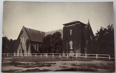
Holy Trinity Anglican Church is one of the parishes of the Diocese of Melbourne in the Anglican Church of Australia. Services of worship began in this building in March, 1863. The Vicarage was built in 1873, and both carry National Heritage classifications. The church contains many stained glass windows dating from the 19th century.Monochrome postcard showing the exterior of Holy Trinity Church, High Street, Kew. The western exterior of the church is viewed from High Street, Kew. The Church is surrounded by extensive vegetation, some later removed. The postcard predates 1913 when the tower was completed."Reg-No-KHS-411. Holy Trinity Church Kew - Prior to tower completion (1913)"holy trinity church -- kew (vic.), churches -- kew (vic.), postcards -- kew (vic.), postcards -- churches (vic.) -
 Rutherglen Historical Society
Photograph - Aerial Images, c2000
The Rutherglen 'Big Wine Bottle', once a water tower to supply the town's water, is now kept as a tourist attraction.Colour aerial photograph of the old Rutherglen water tower with the structure on top to make it look like a wine bottle.water tower, water supply, rutherglen winebottle -
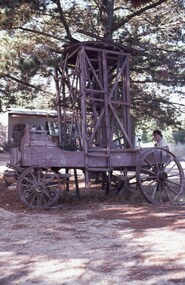 Ballarat Tramway Museum
Slide - 35mm slide/s, David Verrier, ESCo wooden Tower wagon, 26/04/1975
Photo of the first horse drawn tower wagon at Sovereign Hill. This item was offered to the BTPS but declined as it did not have the storage space for it. Understood to have later been dismantled.Yields information about the appearance of the horse drawn tower wagon of ESCo.Agfa colour slide, white blue plastic mount. Photograph Saturday 26/4/1975 at the time of the first COTMA conference. Photo by David Verrier. See also Reg Item 7689 for another photograph by Andrew Howlett.On back of slide in ink' "Saturday 26/4/75 Tower Wagon Sovereign Hill Ballarat"tramways, trams, tower wagon, sovereign hill, cotma -
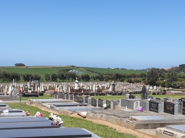 Ballarat Heritage Services
Photograph - Photograph - Colour, Clare Gervasoni, Tower Hill Cemetery, 2019, 03/01/2019
The Tower Hill Cemetery is located near Koroit on the north side of the Princes Highway The, between Port Fairy and Warrnambool. The first burial at Tower Hill Cemetery took place in 1856. Over 150 years there has been over 8,000 burials. Around 45 percent of the burials are in unmarked graves. Colour photograph of the Tower Hill Cemetery. with potatoes being irrigated in te background. The cemetery is laid out on design of a Celtic Cross.tower hill cemetery, tower hill, cemetery -
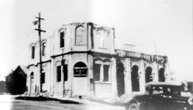 Surrey Hills Historical Society Collection
Photograph, Demolition of Tower House Day and Boarding School, Surrey Hills in 1932 (1)
This building dated back to the 1880s and had previously operated as Delany's Hotel and then the Royal Hotel. It was built near the site of the original Delany's Hotel, built in 1856. The Royal Hotel closed in 1921 after the area voted to be a 'dry area' in the local option poll. Tower House Day and Boarding School operated from 1921 until 1932. Norman Carter took many photos of Surrey Hills and Mont Albert from the 1920s; many were associated with events and activities of the Church of England.Black and white photo of a partially demolished building. The roof and part of the second storey are missing. What remains indicates that it has been a large building in the Victorian style. Along one side at ground level there are 4 arches, perhaps entry to a covered veranda, above which is a colonnade, and perhaps an open veranda on the upper level. There is a mixture of treatments to the surrounds of the windows. On the corner, within an arch which may have once been a doorway, is a sign reading: "TOWER HOUSE / DAY / & / BOARDING SCHOOL". There is a car with a retractable hood in the lower RH Corner of the photo.Rear top centre in blue biro "1932" (crossed out); top RH corner "498" in red biro; centre "Demolition of / Tower House Day & Boarding / cr Canterbury & Broughton Rds / previously Tower House Hotel / originally Royal Hotel / See partner photo."; bottom RH cnr "demol (in red biro) / 20-8-32". All in Jocelyn Hall's handwriting.tower house day and boarding school, schools, education, royal hotel, hotels, construction and demolition, dry area, licensing polls, temperance movement, delany's hotel, norman carter -
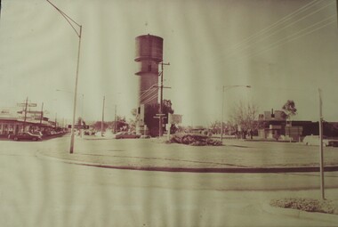
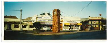 Tatura Irrigation & Wartime Camps Museum
Photograph, Clock Tower intersection, Hogan Street, Tatura
Shows picture of businesses at the Clock Tower intersection, Hogan Street, Tatura,.Colour photograph showing intersection where the Clock Tower is located in Hogan Street, Tatura. Photograph stuck onto piece of white cardboard. hogan street tatura, criterion hotel tatura, max's supermarket tatura, tatura handyman's hardware, tatura florist, tatura post office -
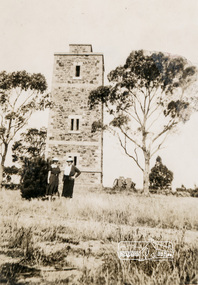
 Eltham District Historical Society Inc
Photograph, Shire of Eltham War Memorial, Memorial Park, Garden Hill, Eltham-Yarra Glen Road, Kangaroo Ground, c.1936
Showing front angle view of tower and old fire watchbox on top On November 11th 1926 the Shire of Eltham War Memorial Tower at Kangaroo Ground was opened. It is regarded as one of Melbourne’s most outstanding lookout towers. It commands a magnificent 360 degree panorama from Kinglake across the Diamond Valley to Macedon and the You Yangs. It is built on a peak which was once a volcano, 237 metres above sea level. After World War one a memorial cairn was erected on the site, and in 1925 a committee of public-minded citizens began to plan for a tower. Many generous donations of material and money were forthcoming so that in 1926 the Governor General Lord Stonehaven was able to unveil the plaque before a crowd of 500 people There was some concern in the 1960s when the Forests Commission wanted to build a firespotters cabin on the top. At first R.S.L. branches opposed the idea, but it was realised that this use could combine with its use as a tourist attraction, and would ensure its maintenance for the future. Today the Kangaroo Ground tower provides one of the best views around Melbourne and is a fitting memorial to those who died in two world wars. From: Historic items for Diamond Valley Community Radio September 1990 (EDHS collection) On November 8th, 1951, the memorial was re-dedicated by the Governor of Victoria, Sir Dallas Brooks with the addition of the names of men from the Shire of Eltham who fell in the Second World War. Further wreaths were added subsequent to this image in time for the 2001 Reembrance Day service to commemorate the men from th shire who had fallen in the Malayan, Korean, Borneo and Vietnam campaigns.Black and white photograph showing front angle view of tower and old watchbox on topgarden hill, kangaroo ground, kangaroo ground memorial, memorial park, shire of eltham war memorial tower, war memorial -
 Whitehorse Historical Society Inc.
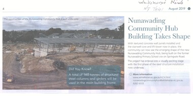
Article, Nunawading Community Hub, 2019
The construction of the Nunawading Community Hub.The construction of the Nunawading Community Hub is taking shape with textures concrete wall panels and the stairwell core and lift tower now in place.The construction of the Nunawading Community Hub.nunawading community hub, city of whitehorse, nunawading primary school no. 4190 -
 Sunbury Family History and Heritage Society Inc.
Photograph, 15th
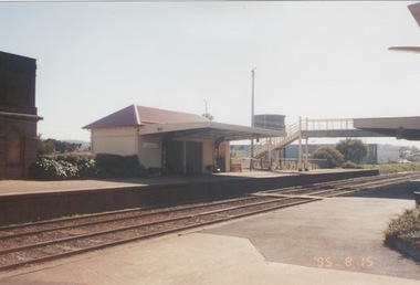
The Number 2 platform at Sunbury Station is featured in this image along with the former wooden pedestrian bridge and partial view of the two water towers, which in the past were used to supply water for the steam engines. A coloured photograph of a platform at a railway station which includes a pedestrian bridge and metal water tower. sunbury railway station -
 Hume City Civic Collection
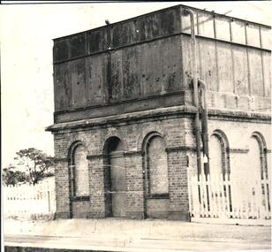
Photograph
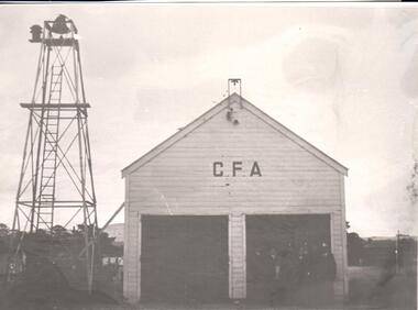
This photograph was taken in Evans Street, Sunbury near Sunbury Square. The wooden structure was the home of the Country Fire Authority and the bell tower was used to raise the alarm for fires.A black and white photograph of a weatherboard fire station next to a metal tower with a bell on top and a ladder leaning against it.sunbury fire brigade, country fire authority, bell towers, fire stations, evans street, sunbury, george evans collection -
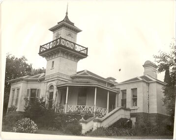 Kew Historical Society Inc
Photograph, J E & B L Rogers, 'Swinton', Swinton Avenue, c.1960
'The land on which 'Swinton'was later built was first purchased by John Bakewell in 1851 and later sold to Edmund Laskey Splatt in 1858. Splatt was a member of the first provisional committee of the National Bank of Australia in Melbourne and built the first house on the land naming it 'Laskey Villa'. By 1863 the house was occupied by Herbert Henty. The Johnson family connection with the property began with the marriage in 1858 of Annabella Johnson to David Syme, owner of the Áge' newspaper and owner of the adjacent property 'Blytheswood'. Annabella's brother, Francis Johnson, bought the villa in 1876 and renamed it 'Swinton' after his birthplace in Yorkshire. The property was later owned by the artistic Colquhoun family. The house is one of the earliest examples of the Italianate style in Victoria - the outstanding element being the tower with its cantilevered walkway and heavily bracketed pryamidal tower.' Source: Victorian Heritage RegisterThis work forms part of the collection assembled by the historian Dorothy Rogers, that was donated to the Kew Historical Society by her son John Rogers in 2015. The manuscripts, photographs, maps, and documents were sourced by her from both family and local collections or produced as references for her print publications. Many were directly used by Rogers in writing ‘Lovely Old Homes of Kew’ (1961) and 'A History of Kew' (1973), or the numerous articles on local history that she produced for suburban newspapers. Most of the photographs in the collection include detailed annotations in her hand. The Rogers Collection provides a comprehensive insight into the working habits of a historian in the 1960s and 1970s. Together it forms the largest privately-donated collection within the archives of the Kew Historical SocietySwinton in Kew and its tower. This side of the house faces the Yarra River.swinton, laskey villa, swinton avenue, kew, dorothy rogers -
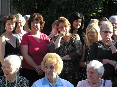 Ballarat Heritage Services
Digital photograph, International Womens Day, Bell Tower Conference Centre, Ballarat
Clare Gervasoni and Dorothy Wickham at International Women's Day function at the Bell Tower Conference Centre, Ballarat at the launch of "Amongst Ballarat's Finest", a publication about some of Ballarat's amazing women. Jacqueline Dark, soloist; Dorothy Wickham, guest speaker.Three photorgraphs of women at the International Womens Day event, Bell Tower Conference Centre, Ballaratinternational women's day, clare gervasoni, dorothy wickham -
Queenscliffe Maritime Museum
Functional object - Bottle
The Victoria Tower was lost on her maiden voyage from Liverpool to Melbourne on 17 October 1869/10/1869 after 85 days at sea. It was wrecked on Lonsdale Reef while approaching Port Phillip Heads. The 2,300 tons cargo contained general cargo, bottled beer, slates, iron pipes and hardware. It was owned by the White Star Line, T. Ismay. The Master of the vessel was Captain Kerr. The weather conditions were hazy, squally, thick and clearing at times. The cause was attributed to running ashore in thick weather and careless navigation. There were 34 passengers and 16 crew members on board all of whom survivied.A beer bottle with an attached sticker Victoria TowerMB, CV, Property of the Manufacturers Bottle Co of Victoria Pty Ltd. Underneath F 40shipwrecks, victoria tower, bottle -
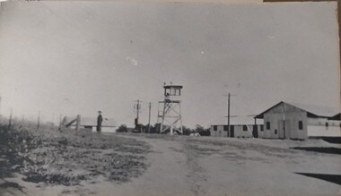 Tatura Irrigation & Wartime Camps Museum
Photograph, Camp Buildings and sentry tower, 1939
Dhurringile camp view. General view of buildings, sentry tower and a lone guard.Black and white photograph of general view of huts, lookout tower, fence and lone soldier with road sweeping front right, swinging left. Taken at Dhurringile Mansion camp.dhurringile pow camp -
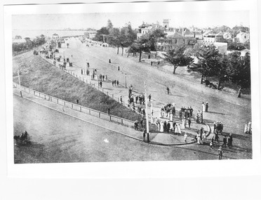
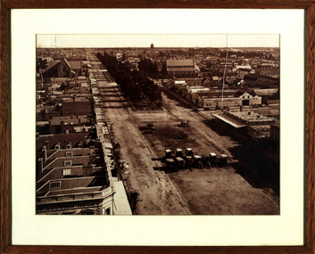 Federation University Historical Collection
Photograph - Photograph - sepia, Ballarat Looking West from the Town Hall, 1872, 1972
This photograph was taken from the newly completed tower of the Ballarat Town Hall. Further details on the photographer, William H. Bardwell, can be found at http://bih.ballarat.edu.au/index.php/William_H._BardwellFramed sepia photograph showing Sturt Street Ballarat as taken from the Ballarat Town Hall. The bluestone St Patrick's Cathedral can be seen in the background to the left, with St Andrew's Kirk opposite it. The two towers in the centre background are the Ballarat West Fire Brigade and the Ballarat Hospital tower (Drummond Street).ballarat town hall, ballarat, bardwell, sturt street, horse drawn carriage, gibbings's livery stables, gibbings, proctor, proctor coach builder, ballarat hospital, carriages, ballarat west fire brigade, ballarat streetscape, ballarat townscape, william bardwell, fotobiennale -
 Rutherglen Historical Society
Images, 1960s
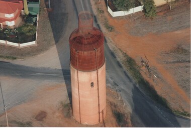
One of a collection of photographs from the Iggsten Estate. The water tower in the background is located in Hunter Street and was built in 1899-1900 to serve as the town's water supply. A new reservoir was built in 1945 with water being pumped from the Murray. A steel mesh structure, to make it look like a wine bottle, was added to the top in 1969 with funds from the Rutherglen Wine Festival.Black and white photograph of a water tower, at the top of a hill, silhouetted against the sky.water tower, wine bottle, tourism -
 Hume City Civic Collection
Photograph, c 1974
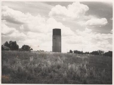
The mounted photograph is one of a series used for display purposes. The water tower at Sunbury Station was built in 1861 by J. Bett. it is of state significance and is an indicator of the importance of the railway to Sunbury's expansion in the Nineteenth Century. Steam trains needed sufficient steam power to climb the steep gradients over the Great Dividing Range and the water tower at Sunbury was used to replenish the trains' water supply for the remainder of the journey.A black and white photograph of the water tower at Sunbury Railway Station. The base of the tower is a brick construction with an arched doorway and two bricked in arched windows at either side of the doorway and a further two bricked in arched windows on the side. Above the base is a large square iron water storage tank with two downpipes at the side. There is a picket fence either side of the building. Mounted on board.sunbury railway station, water towers, victorian railways, bett, j., george evans collection -
 Tatura Irrigation & Wartime Camps Museum
Album - Photograph album, Tatura Water Tower Mural Project
Book presented to the Museum from Tatura RSL showing the work that went into creating the Tatura Water Tower Mural. The Water tower on the north side, depict a full size picture of Sir John Monash in uniform. The south side of the tower depicts a thread of poppies. Sir John was the engineer who designed the water tower which was opened in 1912. A letter from Tatura RSL is in the book.White hard covered book. Front has two pictures of a water tower. One has poppies on it and the other a man in Army uniform. Back cover has to picture of part of a building with Victory Hall on it and the Australian flag up a flag pole flying.tatura rsl, tatura water tower mural, sir john monash, water tower engineers -
 City of Ballarat Libraries
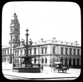
Glass Slide, Ballarat Post Office
It is believed the ball on the tower flag pole was raised and lowered to indicate when mail had been sorted and was ready.Previously unknown image of Ballarat. The set and its subjects indicate these images were produced to promote Ballarat and were perhaps aimed at tourists.Ballarat Post Office, ne corner Sturt and Lydiard Streets, image not dated but tower erected 1885. In foreground Burke and Wills memorial fountain, erected 1867.horse and cart, fountain, telegraph pole