Showing 190 items matching "victoria floods"
-
 Wodonga & District Historical Society Inc
Album - Hume Reservoir Australia Album - Detail plan and explanation, Department of Public Works, N.S.W, 1927
This set of photos is from a leather bound album bearing the inscription "HUME RESERVOIR AUSTRALIA" plus 'The Rt. Hon. L. C. M. S. Amery, P. C., M .P.' all inscribed in gold. It was presented to The Rt. Hon. L. C. M. S. Amery, P. C., M. P, Secretary of State for Dominion Affairs on the occasion of his visit to the Hume Reservoir on 2nd November 1927. This album is of local and national significance as it documents the planning and development of the Hume Reservoir up to 1927. It was the largest water reservoir in the British Empire. The album records the pioneering engineering work that went into its construction.2. Detail Plan and Section. Starting from the New South Wales and there will be an earthen embankment 430 feet 6 inches long which is retained by the North Wing Wall. Then come the sluice section 284 feet 3 inches long, the spillway 720 feet long and the South Wing Wall, making a total length of 1,042 feet 6 inches of concrete wall. Beyond the South Wing Wall is earth embankment again to a length of 3,827 feet. The Full Supply Level is R.L.626.00 and allowance has been made for a surcharge of 9 feet. A road will run along the top of the dam at R.L.642.00. The sluice section contains seven offlets, the three nearest the north wing wall being 13 feet in diameter for hydro-electric purposes and the other four 9 feet in diameter for regulation purposes only. There are to be stony sluice gates on the upstream ends of the outlets and needle valves on the downstream ends. The shock of the discharged water will be taken by a stilling pool. Trash racks will protect the intake ends of the outlets. Next comes the spillway section, which is curved on the downstream face, and carried up to within 15 feet of the full supply level. Above that will be a series of piers between which will be the flood gates and on top of which the roadway will be carried. The gates will be 20 feet wide and 15 feet high and will be 29 in number. They will slide down the face of the wall when opened for the escape of the water. The investigation of the control of this cascade of water was made by means of a model and as a result the form of “bucket” or energy dissipater shown on the section of the spillway was decided upon. The earth embankment in Victoria is being constructed by the State Rivers and Water Supply Commission of Victoria who are the Constructing Authority for that State under the River Murray Waters Agreement. The core of the embankment is of concrete 6 feet wide at the base tapering to 2 feet at the top end and is reinforced with steel rods from the level of the decomposed rock upwards. On the downstream side, at about natural surface level, is a tunnel for drainage and inspection purposes. Above the tunnel is a vertical layer of large stones to drain any seepage to the tunnel. Against the core wall is packed selected material of as impervious a character as can be got locally and beyond that the bank is carefully built up in horizontal layers by means of horses and wheel scoops. The upstream slope is 3-to-1 hardening to 2½-to-1 at the top and the downstream slope is 2½-to-1 hardening to 2.07-to-1 at the top. The thrust of the upstream toe is taken by a mass of granite blocks, and this face is protected by concrete laid in situ. The width of the bank at base is 650 feet and at top 32 feet.hume reservoir australia, river murray waters scheme, hume weir diagrams, hume plan details -
 Wodonga & District Historical Society Inc
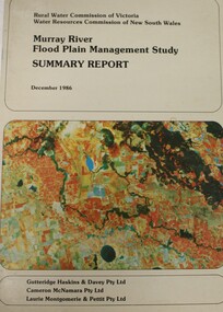
Book - Murray River Flood Management Study December 1986 - Summary Report, Rural Water Commission of Victoria
This publication is the Summary Report of a study of the management of water resources and management of the Murray River. It was jointly commission by the Rural Water Commission of Victoria and the Water Resources Commission of New South Wales. The Rural Water Commission of Victoria was established in 1984. The Commission was renamed in 1992, becoming the Rural Water Corporation. The Water Resources Commission of NSW was constituted in 1976. The Water Administration Act, 1986 abolished the Water Resources Commission replacing it with the Department of Water Resources on 1 January 1987.non-fictionThis publication is the Summary Report of a study of the management of water resources and management of the Murray River. It was jointly commission by the Rural Water Commission of Victoria and the Water Resources Commission of New South Wales. The Rural Water Commission of Victoria was established in 1984. The Commission was renamed in 1992, becoming the Rural Water Corporation. The Water Resources Commission of NSW was constituted in 1976. The Water Administration Act, 1986 abolished the Water Resources Commission replacing it with the Department of Water Resources on 1 January 1987. floodplain management -- murray river, water resources -
 Wodonga & District Historical Society Inc
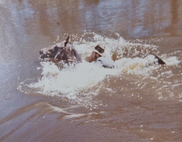
Album - Ringer's River by Des Martin - Plate 29 - Keiran drowns
A flash flood caused by the cloudburst upstream catches them all in the river and Keiran is drowned.The album and images are significant because they document literature written by a prominent member of the Wodonga community. The presentation of this precis was supported by several significant district families and individuals.Ringer's River Album Coloured photo Plate 29des martin, many a mile, ringer's river, northeast victoria stories -
 Wodonga & District Historical Society Inc
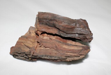
Geological specimen - Murray River Red Gum Geological Specimen c. 6000 BP
This wood was cut from a 6000 year old Murray River red gum retrieved from the Wodonga gravel pits on the flood plain. The Museum of Victoria displayed this wood in the base on which Phar Lap stands. It was made by Kevin Barton of the Kiewa Valley to the order of Dr. James Bowler, the geologist who dated the ancient gravel pit red gums. This specimen is historically significant and unique in local, national, and international context. It is unique, of scientific and research value, and exceptionally rare due to its age. 6000 year old wood from a Murray River red gum. geology, geological, murray river, red gym, murray river red gum, kiewa, wodonga, history -
 Wodonga & District Historical Society Inc
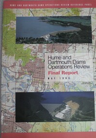
Book - Hume and Dartmouth Dams : Operations Review Final Report and Recommendations, Hume and Dartmouth Dams Operations Review Reference Panel, May 1999
During 1997 and 1998, the Hume and Dartmouth Dams Operations Review Reference Panel has undertaken a broadly based review of the way in which these two major water storages were operated. The Panel’s terms of reference were essentially to consider how the operating rules might be amended to better address the competing objectives of water supply, environmental enhancement and flood mitigation. This report includes summaries of feedback considered by the reference panel as well as its final recommendations.non-fictionDuring 1997 and 1998, the Hume and Dartmouth Dams Operations Review Reference Panel has undertaken a broadly based review of the way in which these two major water storages were operated. The Panel’s terms of reference were essentially to consider how the operating rules might be amended to better address the competing objectives of water supply, environmental enhancement and flood mitigation. This report includes summaries of feedback considered by the reference panel as well as its final recommendations.hume reservoir nsw, dartmouth dam victoria, water management -
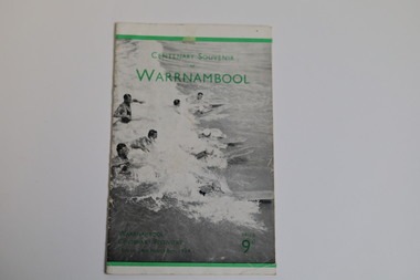 Warrnambool and District Historical Society Inc.
Booklet - Centenary Souvenir of Warrnambool, H. J. Paynter, 1934
In 1934, Victoria and Melbourne celebrated their centenaries. Realising how impossible it would be for the majority of Warrnambool residents to participate in the Victorian celebrations, the organising committee of the Warrnambool Centenary celebrations devised a week long comprehensive programme of activities including exhibitions, a pageant re-enactment at the breakwater and a mass children's display at the showgrounds. Sir Harold Gengoult Smith officially opened the Warrnambool Centenary Exhibition of Arts, Crafts, Antiques and Historical Relics. This booklet was designed and written in 1934 for the Warrnambool Centenary festivities by Frank H. Ford, Lava Street, Warrnambool. The souvenir booklet contains a brief history of Warrnambool, a map and description of Warrnambool and its facilities in 1934.The last three pages include a business directory which would be useful for research.A twenty page booklet printed on shiny paper. The front cover has a black and white photo of nine swimmers in the water (five male & four female) some with surfboards. There is a 4mm green line printed 12mm from the upper edge and a 3mm green line printed 6mm from the lower edge of the cover. There is green printing over the photograph on the front cover. On the rear cover there are two small black and white photographs of an aerial view of the city of Warrnambool and the Hopkins Falls in flood. The green line extend across the rear cover and are intersected by a perpendicular 4mm green line running from the upper to the lower edge 18mm to the left of the spine. Words are printed in black on the rear cover and the printer details are printed in green at the bottom edge.Front cover: Centenary Souvenir of Warrnambool Warrnambool Centenary Festivities 13th to 24th November 1934 Price 9d Rear Cover: Beautiful Warrnambool "City of the West" Victoria Australiawarrnambool, frank h. ford, foyle photos, a. wilkins photos, warrnambool centenary festivities 1934, warrnambool souvenir, warrnambool business directory -
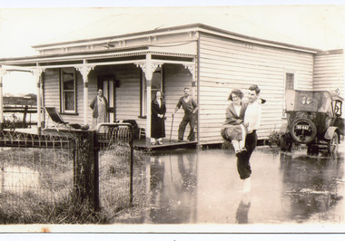 Lakes Entrance Historical Society
Photograph - Rosemont/Fraser, 1935 C
Sepia toned photograph of a man carrying a woman through flood water surrounding Rosemont House, Barkes Avenue. On the veranda of boarding house are Alice Fraser nee Falk, her daughter Joan and husband George leaning on stick, beside house is a soft topped sedan car with sign Telsons on back, Lakes Entrance Victoria.genealogy, guesthouses, floods -
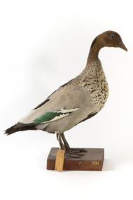 The Beechworth Burke Museum
Animal specimen - Australasian Wood Duck (male), Trustees of the Australian Museum, 1860-1880
The Australasian Wood Duck is commonly described as 'goose-like' in appearance. They reside throughout Australia and Tasmania in regions including grasslands, open woodlands, wetlands, flooded pastures and along the coast and bays. Unlike some breeds of ducks, this species can walk on land with ease and can often be seen perched on logs and in trees. The Wood Duck eat grass, clover and other herbs. On occasion they eat insects. This specimen is part of a collection of almost 200 animal specimens that were originally acquired as skins from various institutions across Australia, including the Australian Museum in Sydney and the National Museum of Victoria (known as Museums Victoria since 1983), as well as individuals such as amateur anthropologist Reynell Eveleigh Johns between 1860-1880. These skins were then mounted by members of the Burke Museum Committee and put-on display in the formal space of the Museum’s original exhibition hall where they continue to be on display. This display of taxidermy mounts initially served to instruct visitors to the Burke Museum of the natural world around them, today it serves as an insight into the collecting habits of the 19th century.This specimen is part of a significant and rare taxidermy mount collection in the Burke Museum. This collection is scientifically and culturally important for reminding us of how science continues to shape our understanding of the modern world. They demonstrate a capacity to hold evidence of how Australia’s fauna history existed in the past and are potentially important for future environmental research. This collection continues to be on display in the Museum and has become a key part to interpreting the collecting habits of the 19th century.This male Australian Wood Duck has a dark brown head with a pale brown-grey speckled body. The lower belly of this specimen is dark brown and the bill is a pale grey-yellow. The legs are a pale grey and stand upon a wooden platform. There is a paper tag tied to the upper part of the Wood Duck's right leg, a white label attached to the front right of the wooden platform and a grey label on the left beside the white label. 132. / Maned Goose / Male / 132taxidermy mount, taxidermy, animalia, burke museum, beechworth, australian museum, skin, reynell eveleigh johns, bird, australian birds, australaisian shovelor, shovelor, wood duck, male, male duck, australian wood duck -
 Lakes Entrance Historical Society
Photograph, 2012
Date made December 2012Colour photograph of the railway bridge over Boggy Creek at Nowa Nowa. Bridge is built on combination of solid concrete piers, timber trestle piers on concrete to flood level, and timber piers. Nowa Nowa Victoriabridges, waterways, transport -
 Lakes Entrance Historical Society
Photograph - Floods, 1952
... Date made June 1952 Floods Halls Houses Roads and Streets ...Date made June 1952Black and white small format photograph of flood waters in Mechanics Street, showing extent of inundation around Mechanics Hall on left and having housing on right of image looking towards Cunninghame Arm. Lakes Entrance VictoriaOn reverse - Flood water near Mechanics Hall June 1952. The pumps were working when this was taken.floods, halls, houses, roads and streets -
 Lakes Entrance Historical Society
Photograph - Floods, 1934
... seen at lobby steps. Lakes Entrance Victoria Photograph Floods ...Severe flooding all over Gippsland in August 1934. All low lying areas of Lakes Entrance flooded.Black and white photograph of flood waters around the Mechanics Hall. Shows external stairway to bio-box addition for film projector. Mr Syd Allen projectionist seen at lobby steps. Lakes Entrance VictoriaOn Back Old Cat No 77floods, halls, houses, roads and streets -
 University of Melbourne, Burnley Campus Archives
Newspaper - Newspaper Cutting, The Age, Horticultural Society, 1865
... of victoria flood damage ornamental garden used for fruit trees ...Copy of article in "The Age" 20 July, 1865 p7. Description of Annual General Meeting. Grounds unfit for purpose after 1863 flood. Young stock being planted in part of Ornamental Garden. Government allowing Society to select more suitable ground near to present garden.floods, gardens, annual general meeting, horticultural society of victoria, flood damage, ornamental garden used for fruit trees, additional grant of land -
 Bendigo Historical Society Inc.
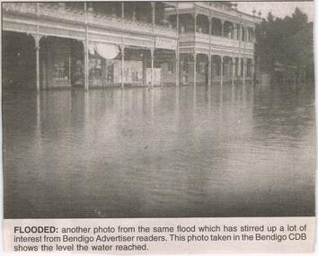
Newspaper - JENNY FOLEY COLLECTION: FLOODED
Bendigo Advertiser ''The way we were'' from 2003. Flooded: another photo from the same flood which has stirred up a lot of interest from Bendigo Advertiser readers. This photo was taken in the Bendigo CBD shows the level the water reached. The Way we were picture confusion: the way we were picture in the Bendigo Advertiser on February 5 is in fact not Bendigo at all. I believe the picture taken is of Rochester, Victoria. The two main buildings pictured are the Shamrock hotel and the Commercial hotel and next to that hidden behind the tree is the old Westpac building. T. Parsons, the name in the photo, used to be a clothing merchant in Rochester. Written by Brian Leahy, Rochester. The clip is in a folder.newspaper, bendigo advertiser, the way we were -
 Lakes Entrance Historical Society
Photograph - Bullock Island, 1930c
Black and white photograph of Bullock Island, showing the footbridge to the island, the rock groynes at the western end of the island, built to direct flood and tide waters to entrance. Photo taken from Kalimna Hill, scub in foreground. Lakes Entrance Victoriawaterways, islands, township -
 Lakes Entrance Historical Society
Photograph - Business, Lakes Post Newspaper, 1998c
Black and white photograph of the North Arm, showing hire boat jetty covered with flood waters caused by a high tide, four hire boats and rowing boat at jetty. House visible on top of Kalimna Heights in background. Lakes Entrance Victoriaboats and boating, tourism, businesses -
 Lakes Entrance Historical Society
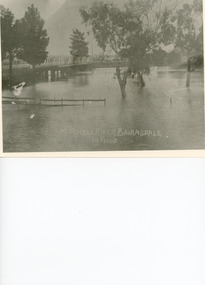
Photograph - Floods, 1919
... Bridges flooding Black and white photograph showing ...Black and white photograph showing Mitchell River in flood at the old highway bridge at east end of town. Roof of Imperial Hotel in background at far end of bridge, trees and fences under water in foreground. Bairnsdale Victoriabridges, flooding -
 Lakes Entrance Historical Society
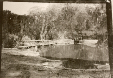
Photograph - Bridges, 1910
Also black and white identical copy 10 x 15 cm, donated by Marion Holding. 02288.1Sepia toned photograph of the old road crossing at Bunga Creek, between Lake Tyers and Lakes Entrance. It shows a rustic footbridge over waterway beside flooded road, horse and buggy with man and woman on board at edge of water. Lakes Entrance Victoriabridges, waterways -
 The Beechworth Burke Museum
Geological specimen - Fossil Leaves
A fossil refers to any remains or traces of past life that are preserved in the rock. It could be remains of plants or animals. Fossil leaves are commonly found on different types of rocks. These fossils can go as far back as the Triassic Age just like the series of fossil plants collected at Denmark Hill, Ipswich in Queensland. Fossils leaves are formed when dead plants get buried by sediments like mud, sand, or volcanic ash. Often, it gets detached cleanly from stems along a special layer of weak cells, then twigs, and, less commonly, cones of conifers and fruits and seeds of flowering plants. Over time, the leaves or pieces of leaves get buried by more sediments and eventually gets 'lithified' or hardened into a rock. Erosions and mining can cause the rocks to break and reveal the fossils buried in it. Fossilisation frequently takes place at sites in the lowlands where deposits of clay, silt, sand are found. This is usually due to weathering and erosion of rocks. Fossil leaves can provide information about ancient Australia's way of living. It contributes to Victorian biodiversity records and its botanical collections. It also contributes information on the geographical profile of Victoria as fossilisation usually occur at estuaries and deltas of rivers, river flood plains, ponds and lakes. This specimen is part of a larger collection of geological and mineral specimens collected from around Australia (and some parts of the world) and donated to the Burke Museum between 1868-1880. A large percentage of these specimens were collected in Victoria as part of the Geological Survey of Victoria that begun in 1852 (in response to the Gold Rush) to study and map the geology of Victoria. Collecting geological specimens was an important part of mapping and understanding the scientific makeup of the earth. Many of these specimens were sent to research and collecting organisations across Australia, including the Burke Museum, to educate and encourage further study.Piece of light brown rock with fossilised leaves in shades of golden yellow and brown.Existing label: Fossil Leaves / Locality unknown / might be worth checking if this is Glossopteris, a Permian age plant. / C. William 16/4/21 geological specimen, geology, geology collection, burke museum, beechworth, fossil leaves, fossilization, 1868 geological survey of victoria, lithified, rocks, fossilised leaf, rock, fossils, leaves -
 Charlton Golden Grains Museum Inc
Photograph, Cameron, Ian, 1973 February Flood, Feb 1973
... , Charlton Victoria, Flood James Paterson Bridge Charlton B/W ...1973 flood. High water depth under Paterson Bridge, Charlton Victoria,B/W photograph of 1973 flood. High water depth under Paterson Bridge.flood, james paterson bridge, charlton -
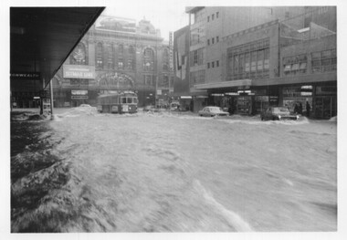 Melbourne Tram Museum
Photograph - Set of 5 black and white - Elizabeth St flood, Peter Duckett, 17-2-1972
Shows the impact of a major rain event near the Victoria Market and the former creek bed of Elizabeth Street acting as a drain. Cars floated and trams were damaged.Yields information about a major rain event in Elizabeth St during 1972 and the impact it had on vehicles and tramway operations.Set of five black and white photographs of major flooding in Elizabeth St 17-2-1972. Copied by the donor from negatives provided by the photographer.floods, elizabeth st, tramways, events, trams, melbourne -
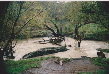 Darebin Parklands Association
Darebin Creek in flood 1990, Darebin Parklands Association, 1990
Colour photograph. This item and all other Darebin Parklands Association archival material is now held by State Library Victoria (Accession No: YMS 13746). Please contact State Library Victoria if access is required. -
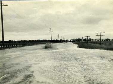 Charlton Golden Grains Museum Inc
Photograph, Charlton Tribune, 1973 Flood, Nov 1971
... Highway, Charlton, Victoria Flood Calder Highway B/W photograph ...1971 flood, Car driving through flood water on Calder Highway, Charlton, VictoriaB/W photograph of 1971 flood. Car driving through floodwater on Calder Highway.flood, calder highway -
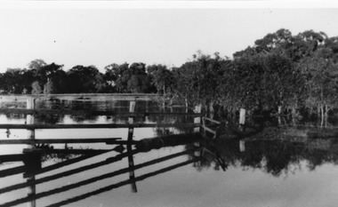 Charlton Golden Grains Museum Inc
Photograph, B/W photograph of Flooded Billabong Cadrows Dairy in the bend of the Avoca River
... River, Charlton, Victoria Flood Charlton Avoca River Cadgow B/W ...Flooded Billabong Cadrows Dairy in the bend of the Avoca River, Charlton, VictoriaB/W photograph of Flooded Billabong Cadrows Dairy in the bend of the Avoca River, Charlton, Victoriaflood, charlton, avoca river, cadgow -
 Charlton Golden Grains Museum Inc
Photograph, Charlton Tribune, B/W Photograph of 1973 Flooded Avoca River, February 1973
... Flood Charlton Victoria...1973 Flooded Avoca River in Charlton Victoria ...1973 Flooded Avoca River in Charlton Victoria at the Paterson Bridge. Water Level 25ft 1 1/2 inches - all local waterunframed 1973 Flooded Avoca River in Charlton Victoria at the Paterson Bridge. Water Level 25ft 1 1/2 inches - all local waterflood charlton victoria, james paterson bridge, local water -
Lakes Entrance Historical Society
Book, Anderson Christopher, The Snowy River Floodplains Railway Bridge, 2003
Research interpretation and management recommendations for the Snowy river Flood plains railway bridge, near Orbost East Gippsland victoria by Forestec studentbridges, transport, employment -
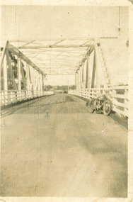 Lakes Entrance Historical Society
Photograph - Bridges, 1940
After 1934 flood damage to second bridge, centre pile was replaced by a truss girder, this survived until 1971 floodBlack and white photograph showing second Orbost Bridge over the Snowy River, wooden planks, railing and overhead support. Motor bike leaning on railing at near end of bridge. Orbost, Victoria.bridges, waterways -
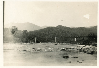 Lakes Entrance Historical Society
Photograph - Bridges
Black and white photograph showing partially built McKillops Bridge on Snowy River, East Gippsland, Victoria.Cantilever new bridge over Snowy River at McKillops Crossing, 45 feet above recorded flood, washed away before officially opened, decking, etc, down stream more than a mile. (on back)bridges, waterways, topography, construction -
 Eltham District Historical Society Inc
Photograph - Digital Photograph, Alan King, Diamond Creek, Barak Bushlands, Eltham, 2008
A habitat corridor and it strengthens the community. Published: Nillumbik Now and Then / Marguerite Marshall 2008; photographs Alan King with Marguerite Marshall.; p185 Barak Bushlands lie west of the Diamond Creek on the corner of Falkiner Street and busy, noisy Main Road. They form part of an important habitat corridor linking the Yarra River to the Kinglake National Park.1 Manna Gums, tawny frogmouths and platypuses are some of the indigenous plants and animals that have made their home there. The bushlands are the result of more than nine years of hard work by the local community with the Nillumbik Council, to transform a degraded flood plain into this refuge of natural beauty. In 1997, shortly after moving into the new Riverside Estate on Falkiner Street, Eltham, several residents noticed the sorry state of the Diamond Creek and surrounding area. Part of it was used as a cow paddock and although small patches of vegetation survived, the area was infested with weeds, rabbits, rubbish and drainage from the housing estate. At various times the 4.4 hectares had been used as a market garden and for shire stock piles. The residents began to restore the area by revegetating land along the Diamond Creek. In 1998 they established the Friends of the Diamond Creek Falkiner Street Reserve2 and 35 families joined from the 90-house Estate. Carolyn Mellor, as the Friends’ Land Manager, undertook a four-year horticulture course to guide this massive project for a volunteer organisation. Since 1999, she has been the Friends’ President. In 1999 the Friends urged the Nillumbik Council to undertake a feasibility study into establishing a wetland system and urban forest. Work began in 2002 with Nillumbik Council funding the project, supplemented by government grants. The Friends also received grants from Melbourne Water and Parks Victoria. Aided by the Friends and other community members, the Council created the Barak Bushlands consisting of a forest, a wetland, a bridge, a path and open space. The beautiful wetland treats most of the estate’s stormwater runoff. Storm water is filtered through plants in the wetland ponds then is released slowly into the billabong, before flowing into the Diamond Creek. The wetland also helps to minimise flooding and the improved water quality provides a flora and fauna habitat. The Friends and other volunteers planted more than 27,000 plants, more than one third of which they grew from seeds they collected at Lower Eltham and Wingrove Parks. Eltham High School students planted thousands of these through a Year Eight program introduced for this purpose. Other groups who assisted were: Green Corps, local Scouts and Guides – 2nd Montmorency, 1st Diamond Creek and 1st Eltham Cub Packs, Eltham College students, Eltham East Primary School, Landcare members, Eltham Lions Club and the Eltham Baptist Church. To maintain enthusiasm for the mammoth task, the Friends and other volunteers ‘adopted’ trees to water and wrote their names on the stakes. In 2004, to recognise the area’s original occupiers, the reserve was named Barak Bushlands. William Barak, who lived from 1824 to 1903, was the last chief of the Yarra Yarra tribe of the Wurundjeri-willam people. Traces of these original inhabitants remain in scar trees (bark sections removed to make a shield or canoe). That same year the Friends’ group was a finalist in the prestigious Federal Government, Banksia Environmental Awards. The Friends have also participated in Clean Up Australia, removing tonnes of rubbish and regularly testing the billabong, wetland and creek, for pollutants. For years the Friends, together with the Australian Platypus Conservancy, have tagged, measured and checked the health of platypuses from the Diamond and Mullum Mullum Creeks. With Latrobe University the Friends have conducted night walks to view owls, possums, bats and sugar gliders. Challenges for the council and the Friends continue with a large rabbit population, some vandalism, weed eradication and maintenance. However, thanks to this community effort, locals can now escape confined urban living on small blocks of land and enjoy the beauty of indigenous plants and animals. Working together has also strengthened the local community,This collection of almost 130 photos about places and people within the Shire of Nillumbik, an urban and rural municipality in Melbourne's north, contributes to an understanding of the history of the Shire. Published in 2008 immediately prior to the Black Saturday bushfires of February 7, 2009, it documents sites that were impacted, and in some cases destroyed by the fires. It includes photographs taken especially for the publication, creating a unique time capsule representing the Shire in the early 21st century. It remains the most recent comprehenesive publication devoted to the Shire's history connecting local residents to the past. nillumbik now and then (marshall-king) collection, barak bushlands, diamond creek (creek), eltham -
 Eltham District Historical Society Inc
Photograph - Digital Photograph, Marguerite Marshall, Eltham Retirement Centre (Judge Book Memorial Village), Diamond Street, Eltham, 23 October 2006
Thousands of elderly people at this centre have contributed much. Published: Nillumbik Now and Then / Marguerite Marshall 2008; photographs Alan King with Marguerite Marshall.; p161 Thousands of elderly people, who have contributed much to Nillumbik and beyond, have made their home in the treed Eltham Retirement Centre. The centre, which opened in 1956, has housed the disadvantaged in particular, through good times and hard, including floods, fire and even burglaries. As part of the Melbourne Citymission, a non-denominational Christian organisation that cares for people living with disadvantage, the centre was built to celebrate 100 years of the Melbourne Citymission’s work since 1854. Standing on a former poultry farm called Willandra (Still Waters), the centre includes independent units, hostel, nursing home accommodation and a Day Therapy Centre, which is available for non-residents as well. Despite being metres from the busy Main Road and railway station, the centre provides a quiet oasis on 6.8 hectares bordered by the Diamond Creek to the west, and the railway line to the east. The centre was originally named Judge Book Memorial Village after Judge Clifford Book, Deacon of the Collins Street Baptist Church. Book was also President of the Baptist Union of Victoria and Grand Master of the Masonic Lodge. He was so respected that, at his death, several Pentridge prisoners asked to attend his funeral. In 1993 the centre’s name was changed to clarify that it was part of the Melbourne Citymission. However Judge Book’s name continues in the Judge Book Memorial Garden, opened in 2006. The Diamond Creek has flooded the centre several times, however rarely causing serious damage. Volunteer Alan Field recalls a flood in 1974 when the resident manager Reverend Norman Pearce and his wife, were rescued by boat from their home with their budgerigar. On February 3, 2005, when the creek almost flooded Metzner Hall, 35 ambulances evacuated residents to nearby nursing homes, hostels and local homes. Residents were also evacuated during the 1965 bush fire, but fortunately a change of wind direction saved the centre. Residents have also endured several burglaries. Despite much rebuilding and modernisation over the years, traces of the original farmhouse remain in the administration areas. In 1991 the Willandra Hostel was built and in 2001 the Eltham Lodge Nursing Home with each room having a garden view. Several buildings are named after people who have given special service to the centre including the Norman Pearce Day Hospital after general manager and pastor Rev Pearce. Metzner Hall was named after the Metzner family who had been active in the auxiliary since it began and had donated generously to the Recreation Hall fund.3 A bridge was named after Sister Lila Murray who had worked at the village for 42 years in various capacities including as relieving manager. Field remembers Sister Murray as ‘the Mother Teresa and soul of what the village aspired to, with love and care’. Since 1957 the Eltham Auxiliary, later called the Residents’ Association, has worked to improve the residents’ quality of life by volunteering and raising funds. An outstanding volunteer, Field, who was drawn to the centre in 1971 with his wife Chris, has held positions on the early Eltham boards, auxiliaries and Residents’ Association. Much of his work has been supporting people with no family and those of limited means. He says he and his wife look at their work as having shared ‘our lives with amazing people’. The wealth of experience and wisdom in the Retirement Village has benefited many people, including local school children. Residents have acted as proxy grand-parents at local schools, by assisting small learning groups or telling their life stories. Conversely, students from local schools have visited to perform, or to assist in programs like craft activities. Resident Val Bell, whose mother Rose Bullock lived at the centre before her, sums up the centre’s most important attribute for her: ‘The Christian care. They could not be more caring’.This collection of almost 130 photos about places and people within the Shire of Nillumbik, an urban and rural municipality in Melbourne's north, contributes to an understanding of the history of the Shire. Published in 2008 immediately prior to the Black Saturday bushfires of February 7, 2009, it documents sites that were impacted, and in some cases destroyed by the fires. It includes photographs taken especially for the publication, creating a unique time capsule representing the Shire in the early 21st century. It remains the most recent comprehenesive publication devoted to the Shire's history connecting local residents to the past. nillumbik now and then (marshall-king) collection, diamond street, eltham, eltham retirement centre, eltham retirement village, judge book memorial village -
 Bendigo Historical Society Inc.
Document - DRAINAGE PROBLEMS - MINERS SENSATIONAL EXPERIENCE AT THE VICTORIA QUARTZ
Handwritten notes from a Bendigo Advertiser report, Thursday June 16th 1910. Management had for some time been apprehensive that the flooding in the deep mines to the south would affect them. Lansell's 180 took the precaution of baling. On the Tuesday night the men at the Victoria Quartz had a sensational experience. The storage dam at 3324 ft level receives the overflow from the flooded mines to the south. The level connects with the 3310 level at the Big 180. The water flows uninterrupted into thestorage dam which has a capacity of about 270 tanks. The dam had been emptied on Tuesday morning and work continued until 10 pm that night. The platman noticed that the water was coming down the shaft in a regular torrent. They didn't take much notice as they thought it was a leakinig outlet valve on the ascending tank. At 11 pm the releiving shift came down the shaft and said that the dam at 3,324 ft must be overflowing. The velocity of the water pouring down the shaft increased and the men made a hurried exit from the bottom of the shaft which is down 310 ft from the 4.254 ft plat (a total depth of 4,564 ft). An inspection of the dam at the 3324 ft level found it to be overflowing. By morning (Wednesday) the shaft had filled, and the water rose to 7 ft in the plat at 4254 feet. Mining inspector hgave orders that men were not to go below the 3324 ft level. Baling continued without cessation at the Big 180 all day and could not lower the water. Drilling machines etc and a powerful air winch at the 4254 ft plat are under water. An inspection made of the 3100 ft level at the 180 mine where the workings are connected with the New Chum & Victoria showed that water was running strongly from that mine proving that the inrush was due to flooded water from the southern deep mines to the south. Document from Albert Richardson Collection of mining history. Document from Albert Richardson Collection of mining history.document, gold, drainage problems, new chum drainage scheme, miners sensational experience at the victoria quartz, bendigo advertiser 16/6/1910 page7, lansell's 180, big 180, new chum & victoria