Showing 522 items
matching victoria. public record office
-
 Ballarat Tramway Museum
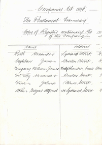
Document - Photocopy, Public Records Office of Victoria, List of Ballaarat Tramway Company Directors, c1994
... by the Public Records Office of Victoria, arranged by Alan Bradley c1994.... underneath. Made from records held by the Public Records Office ...Photocopy over two pages of the Register of Company Directors of the Ballaarat Tramway Co. Limited (horse trams) giving the name, address, occupation and position held within the Company. Made up the Victoria Companies Act. of 1896, Section 166. Document not dated. Has a hand stamp giving the full company name with the name of Secretary underneath. Made from records held by the Public Records Office of Victoria, arranged by Alan Bradley c1994.trams, tramways, horse trams, company directors, ballaarat tramway company, management -
 Ballarat Tramway Museum
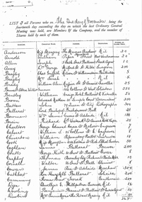
Document - Photocopy, Public Records Office of Victoria, List of shareholders of the Ballaarat Tramway Co, c1994
... . Made from records held by the Public Records Office of Victoria... by the Public Records Office of Victoria, arranged by Alan Bradley c1990 ...Photocopy over three pages of the members (shareholders) and the number of shares held in the Ballaarat Tramway Company Limited (horse trams). Date given as 2nd day of November, but no year given. Possibly 1896 following the introduction of the new Companies Act. Company Secretary was a person with the surname of Brown, possibly Edward Nathan, who is on the list of shareholders and occupation shown as Accountant. List gives Surname, Christian Name, Address, occupation and the number of shares held. Made from records held by the Public Records Office of Victoria, arranged by Alan Bradley c1990.trams, tramways, horse trams, shareholders, ballaarat tramway company, management -
 Ballarat Tramway Museum
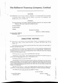
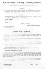
Document - Photocopies, Public Records Office of Victoria, "The Ballaarat Tramway Company Limited - Directors' Report" - BTCo Reports - 1897 - 1902, 1994
... of Company Records held in the Public Records Office of Victoria... Records held in the Public Records Office of Victoria. Item Year ...Photocopies of the half year Directors' reports for the Ballaarat Tramway Company Limited for the period 28 Feb 1897 to 31 August 1902. Gives details of the shareholders meetings and the Directors' reports along with details of Directors standing for office. Photocopies arranged by Alan Bradley c 1990 from files of Company Records held in the Public Records Office of Victoria. Item Year 1247.1 - 2/1897 1247.2 - 8/1897 1247.3 - 2/1898 1247.4 - 8/1898 1247.5 - 2/1899 1247.6 - 8/1899 1247.7 - 2/1900 1247.8 - 8/1900 1247.9 - 2/1901 1247.10 - 8/1901 1247.11 - 2/1902 1247.12 - 8/1902 All reports single page and printed with Edgar A. Akins as Secretary except for the last one, 1247.12, which is typed, mentions the forthcoming takeover by ESCo and the death of the former Company Secretary and signed by George A. Grace as Secretary.trams, tramways, annual reports, ballaarat tramway company, horse trams, edgar a. akins -
 Ballarat Tramway Museum
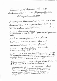
Document - Photocopy, Public Records Office of Victoria, "Summary of Capital & share of the Ballaarat Tramway Co. Ltd. (in Liquidation) up to 21st day of April 1903", c1994
... . Handwritten original. Made from records held by the Public Records... from records held by the Public Records Office of Victoria ...Photocopy over seven pages of the summary of Capital and shares of the members of the Horse tram co. Ballaarat Tramway Co. at 21/4/1903 which was being liquidated following the takeover by ESCo. Gives details of calls on each share, amounts forfeited, details of the Directors and details of each member; Surname, Christian Name, Address, Occupation and amount of shares held. Handwritten original. Made from records held by the Public Records Office of Victoria, arranged by Alan Bradley c1990.trams, tramways, horse trams, shareholders, ballaarat tramway company, liquidation -
 Ballarat Tramway Museum
Document - Photocopy, Public Records Office of Victoria, "Statutory Declaration verifying Liquidators' Statement in the matter of the Ballaarat Tramway Co. in liquidation.", c1994
... . Made from records held by the Public Records Office of Victoria... by the Public Records Office of Victoria, arranged by Alan Bradley c1990 ...Photocopy over three pages of the Statutory Declaration verifying Liquidators' Statement in the matter of the Ballaarat Tramway Co. in liquidation. Gives details of the liquidation, the names of the liquidators and details of the final accounts of the horse tram operator, Ballaarat Tramway Co. dated 23/10/1903. Made from records held by the Public Records Office of Victoria, arranged by Alan Bradley c1990.trams, tramways, horse trams, shareholders, ballaarat tramway company, liquidation -
 Ballarat Tramway Museum
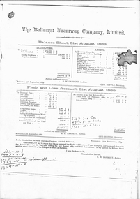
Document - Photocopies, Public Records Office of Victoria, BTCo Financial Reports, 1994
... in the Public Records Office of Victoria. Item Year 1250.1 - 8... in the Public Records Office of Victoria. Item Year 1250.1 - 8/1889 ...Photocopies of the half yearly financial reports for the Ballaarat Tramway Company Limited, giving details of the Balance sheets, the Profit and Loss statement and the Auditors reports (first three only) for the periods 31/8/1889 to 31/8/1890 (three number) and 28 Feb 1897 to 31 August 1902. Photocopies arranged by Alan Bradley c 1990 from files of Company Records held in the Public Records Office of Victoria. Item Year 1250.1 - 8/1889 1250.2 - 2/1890 1250.3 - 8/1890 1250.4 - 2/1897 1250.5 - 8/1897 1250.6 - 2/1898 1250.7 - 2/1899 1250.8 - 8/1899 1250.9 - 2/1900 1250.10 - 8/1900 1250.11 - 2/1901 1250.12 - 8/1901 1250.13 - 2/1902 1250.14 - 8/1902* All reports single page and formally typeset and printed. *1250.14 - Profit and loss account hand copied and type following being missed in the photocopying by the PROV. Rest of statement, typed and copied over two pages.trams, tramways, annual reports, ballaarat tramway company, horse trams, financial statements -
 Ballarat Tramway Museum
Document - Photocopy, Public Records Office of Victoria, "Proceedings of Inquest - Elizabeth Clarke, Ballarat", 19/02/2007 12:00:00 AM
... /3/1936. The copy of the inquest from the Public Records.... The copy of the inquest from the Public Records Office Victoria ...Yields information about a serious head on collision between two trams in Wendouree Parade, issues with the systems and tramcars and training. Gives extensive details of the accident and its consequences.Twenty Seven page photocopy of a Coroner's Inquest and proceedings into the death of Elizabeth Clark in Ballarat following a collision between Scrubber Tram and No. 26 in Wendouree Parade, 5/2/1936, near Barrett Avenue. The Coroners Inquest was held on 4/3/1936. The copy of the inquest from the Public Records Office Victoria - VPRS 24/P/O, unit 1303, file 1936/302. For detail scans of photographs by the Police Photographer see Reg. Item 3688. Contains witness statements by: Henry Morganti (Barrister & Solicitor), Dr. William Griffiths, Lillian Oliver (passenger on tram), Jean Oliver (passenger on tram), George Stock (Police Photographer), Alfred Forte (SEC - Tram track assistant), Albert Mawby (Inspector - SEC), Frederick Thompson (Driver of No. 26), John Tucker (Driver of the Scrubber Car) and 1st Constable Roy Vinnicombe (Victoria Police).On rear - PROV stamp and file number.trams, tramways, accidents, collision, coroners inquests, wendouree parade, barrett ave -
 Ballarat Tramway Museum
Document - Photocopy, Public Records Office of Victoria, "Inquisition, Proceedings - Bernard John Bourke, Ballarat", 26/02/2007 12:00:00 AM
... from the Public Records Office Victoria - VPRS 24/P2, unit 62.... The copy of the inquest from the Public Records Office Victoria ...Yields information about a collision between a tram and motor vehicle at the Victoria St terminus and issues with the driver of the motor vehicle being fatigued and the effects of alcohol - see article written on Coroners inquests by Alan Bradley.Ten page copy, from scanned original of a Coroner's Inquest and proceedings into the death of Bernard John Bourke in Ballarat following a collision between a motor car driven by the deceased and SEC tram No. 12 at the Victoria St terminus on, 5/7/1963. The Coroners Inquest was held on 28/8//1963. The copy of the inquest from the Public Records Office Victoria - VPRS 24/P2, unit 62, file 1963/1399. For detail scans of photographs by the Police see Reg. Item 3710. Contains witness statements by: Desmond Ian Domaschenze - Motorman SEC, William Alexander Maes, Motorman SEC and Constable Neil Thomas Patterson. Not copied was the post mortem report: The deceased, Bernard John Bourke, was dead on arrival at Ballarat Base Hospital. A post mortem on 7 July found fractures of ribs and associated lung damage, and concluded that “death was caused by stove in chest”. On 8 July Bourke’s blood was analysed. The conclusion: “I analysed this blood and found it to have an alcohol content of 0.120%. This blood alcohol level in an eleven stone man would be equivalent to the minimum consumption of eight, seven ounce glasses of beer”. This was transcribed by Alan Bradley from the file.On rear - PROV stamp and file number.trams, tramways, accidents, collision, coroners inquests, victoria st -
 Ballarat Tramway Museum
Document - Photocopy, Alan Bradley, "Plan and Front Elevation of Car Depot", 2000
... by the Public Records Office Victoria of the Ballarat ESCo Tramway Depot... held by the Public Records Office Victoria of the Ballarat ESCo ...Set of three A3 size photocopies of a drawing held by the Public Records Office Victoria of the Ballarat ESCo Tramway Depot, dated 2/8/1912. Drawn at a scale of 1/16" = 1', shows building layout, track layout, overall dimensions, a proposed extension to hold eleven trailers, a front elevation showing pits, extension (drawn at 1/8" = 1'). On the current tracks, shows the individual track capacities - 26 trams. Drawings copied by Alan Bradley for archives and research.trams, tramways, ballarat, esco, depot, drawings -
 Ballarat Tramway Museum
Document - Photocopy, Alan Bradley, "Tram Depot / Wendouree Pde. Ballarat", 2000
... held by the Public Records Office Victoria of the Ballarat SEC...-T11-8574 held by the Public Records Office Victoria ...Set of four A3 size photocopies of a drawing BA-T11-8574 held by the Public Records Office Victoria of the Ballarat SEC Tramway Depot, dated c1936. Drawn at a scale of 1" = 16', shows building layout, track layout, overall dimensions, fence types and gates. A front elevation showing the new facade and an internal elevation (drawn at 1/8" = 1'). Drawings copied by Alan Bradley for archives and research.trams, tramways, ballarat, sec, depot, drawings -
 Ballarat Tramway Museum
Document - Photocopy, Alan Bradley, "Car Depot / Wendouree Pde.", 2000
... by the Public Records Office Victoria of the Ballarat SEC Tramway Depot.../8709c held by the Public Records Office Victoria of the Ballarat ...Set of four A3 size photocopies of a drawing VB4/8709c held by the Public Records Office Victoria of the Ballarat SEC Tramway Depot, dated 5/11/1971, Revision C 22/11/1971. Drawn at a scale of 1" = 20', shows building layout, track layout, overall dimensions, tree locations, pit details, rooms, paint shop, reduced levels, streets, toilets, steps to pits, tennis court and datum point. Drawn after the closure of the tramways, possibly to enable planning for the redevelopment and sale of the property. Drawings copied by Alan Bradley for archives and research.trams, tramways, ballarat, sec, depot, drawings -
 Ballarat Tramway Museum
Document - Photocopies, Alan Bradley, "The Electric Supply Company of Victoria Limited - Annual Reports", c1995
... from the Public Records Office of Victoria, Company Reports... of finalising the sale. Photocopies from the Public Records Office ...Set of A4 photocopies of 15 years of annual reports of The Electric Supply Company of Victoria Limited from 1920 to 1934. Most of the reports comprise three sheets - Directors Report, left hand side of the Balance Sheet, Trading Account and Profit and Loss Account on the right hand side. Some reports have a statutory declaration by the Manager and Secretary that the reports submitted are a true copy of the report. Items .1 to .12 detail the number of lamps connected, passengers carried and trading account for the last three years. This practice stopped when ESCo sold the company to the SEC but continued to manage it for a further four years. The Directors report from 9/1900 note the forthcoming sale of the company to the British Insulated Wire Company Limited and the problems of finalising the sale. Photocopies from the Public Records Office of Victoria, Company Reports, obtained by Alan Bradley c1995. All three sheets, unless noted otherwise. .1 - 1919 - 1920 .2 - 1920 - 1921 .3 - 1921 - 1922 .4 - 1922 - 1923 .5 - 1923 - 1924 .6 - 1924 - 1925 .7 - 1925 - 1926 - four sheets .8 - 1926 - 1927 .9 - 1927 - 1928 - four sheets .10 - 1928 - 1929 .11 - 1929 - 1930 .12 - 1930 - 1931 - four sheets .13 - 1931 - 1932 - four sheets .14 - 1932 - 1933 .15 - 1933 - 1934 Items separated by yellow coloured A4 sheets.trams, tramways, esco, british insulated wire company, annual reports, directors reports -
 Ballarat Tramway Museum
Document - Photocopies, Alan Bradley, "The Ballaarat Tramway Company Limited - Half Yearly Reports", c1995
... of finalising the sale. Photocopies from the Public Records Office... from the Public Records Office of Victoria, Company Reports ...Set of A4 photocopies of 6 years of half yearly reports of The Ballaarat Tramway Company Limited (Horse Trams) from 3/1897 to 9/1902. All reports except the last one comprise a two sheet printed or typeset report giving notice of meeting, directors report, statement of assets and liabilities, share structure and profit and loss account. The last report 9/1902 is typed, and lists assets and credits only on the profit and loss account. Meetings were held at Craig's Hotel, Lydiard St. The Directors report from 9/1900 note the forthcoming sale of the company to the British Insulated Wire Company Limited and the problems of finalising the sale. Photocopies from the Public Records Office of Victoria, Company Reports, obtained by Alan Bradley c1995. .1 - 3/1897 .2 - 9/1897 .3 - 3/1898 .4 - 9/1898 .5 - 3/1899 .6 - 9/1899 .7 - 3/1900 .8 - 9/1900 .9 - 4/1901 .10 - 10/1901 .11 - 3/1902 .12 - 9/1902 All reports signed by the Company Secretary Edgar A. Akins, except the last one, Geo A Grace. The report notes that Mr. Akins had passed away. Geo. Grace was appointed as Secretary Pro-tem. Items separated by yellow coloured A4 sheets.trams, tramways, ballaarat tramway company, horse tram, esco, british insulated wire company, annual reports, directors reports -
 Ballarat Tramway Museum
Document - Photocopies, Alan Bradley, Liquidator's Statement of the winding up of the Ballaarat Tramway Company, c1995
... Photocopy of a four page document, from the Public Records... Photocopy of a four page document, from the Public Records Office ...Photocopy of a four page document, from the Public Records Office of Victoria, c1995 of the Statutory Declaration verifying the Liquidator's Statement of the winding up of the Ballaarat Tramway Company (Horse Tramway) 27/11/1903. Made under the Victorian Companies Act of 1896. First page - cover page - with Victorian Company Registrar General's stamp. Second page - Statutory declaration Third and Fourth page - statement of accounts over two pages giving details of the realization and disbursements and an analysis of balance. Gives details of dividends to share holders - 10/- share on 21/1/1903 and final dividend of 1/2d per share on 17/7/1903.trams, tramways, ballaarat tramway company, horse tram, winding up, liquidators statement -
 Bendigo Historical Society Inc.
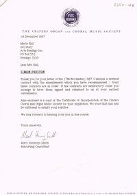
Document - MERLE HALL COLLECTION: VARIOUS INWARDS CORRESPONDENCE
... as to their use of Plaza Theatre, Geelong; Public Record Office Victoria... as to their use of Plaza Theatre, Geelong; Public Record Office Victoria ...Various Inwards Correspondence from; Crafers Organ and Choral Music Society re Simon Preston; Bendigo Woollen Mills re Craft exhibition; Craft Council of Victoria; Sandhurst Trustees re sponsorship of Craft Exhibition; Regional Arts Victoria re 2001 closure of Arts Bendigo; Bendigo Advertiser re 1988 Annual Supplement; Don Mackay - 2001 congratulatory letter to AB; Barry Ackerman (Mayor) with congratulations to AB 2001; John Little congratulations 2001 to AB; Roman Rudnytsky (pianist) re forthcoming visit 1997; Marketing Images & Technology re visit of Simon Preston 1988 (with supplementary material); William Feasley- guitar?- re confirmation of Bendigo performance (no stated year); Geelong Society of Operatic and Dramatic Art re information as to their use of Plaza Theatre, Geelong; Public Record Office Victoria re application for Local History Grants Program; sue Prain re possible appointment as coordinator/rehearsal leader of Bells and Brass Project; Victorian Arts Council (1981) re performance of ''You're a Good Man, Charlie Brown''; Australian Dance Theatre re details of trip to Bendigo October 1987; Sandhurst Trustees Bendigo Easter Fair Festival (1997) re inclusion of AB/BRAC event - ''Facing the Music''; Victorian Arts Council re letter of agreement for ''Wish You Were Here'' (1993). -
 Ballarat Tramway Museum
Document - Display Board with mounted signs, Peter Lambert, 23/04/2020 12:00:00 AM
... in Shelters through a Public Records Office of Victoria grant during... installed in Shelters through a Public Records Office of Victoria ...Set of 12 A3 proofs, colour, for comment in a large envelope with notes on the outside written by Dave Macartney of the almost final versions of the 12 panels that were installed in Shelters through a Public Records Office of Victoria grant during March 2020. Designed by Peter Lambert Design. 1 - Depots backed by Victoria St 2 - Tram Types - backed by the Mt Pleasant Line 3 - Beginnings backed by the Lydiard St Line 4. - Conductors backed by the Sebastopol line 5 - Carlton St backed by Trams in the City 6 - The Gardens backed by The Gardens lines. The final version for the two at St Aidans drive were changed following Council consultation into a different sized panel but with the same content. Image files are those from Peter Lambert that went to the panel makers. Panels by The Sign Shop The image files are not opened by this program. trams, tramways, displays, interpretation, pro, grants, st aidans drive, gardens, depot, tramcar design, carlton st, world war i -
Bendigo Historical Society Inc.
Booklet - The Civil Establishment of the Colony of Victoria for 1851
Port Phillip was first settled in 1803 and became a part of NSW in 1836. It became it's own governing colony in 1851. This statistical book lists public servants for the colony alphabetically, their role, place of employment, and a page reference to a description of the role can be found. Included positions in the fields of Government officers, Police , penal, judicial medical, ecclesiastical and education. Includes salaries for the various positions.Blue soft cover booklet of 76 pages. Titled 'The Civil Establishment of The Colony of Victoria for the Year 1851' Reproduced in facsimile from the Victoria 'Blue Book, No,1 First published in 1976 by the Public Record Office, Melbourne. Printed by C.H.Rixon, Government Printer, Melbourne civil establishment, victoria 1851 -
Bendigo Historical Society Inc.
Booklet - Statistics and Civil Establishment of the Colony of Victoria for 1856
Victoria became its own colony in 1851, after being the Port Phillip district of NSW from 1803. These books that were produced regularly to provide statistical information of the Civil, Judicial, Police, Penal, Medical, Ecclesiastical and educational establishments. The civil list includes public servants, listed alphabetically, their role, place of situation and reference to a later page that describes the actual role.113-page blue soft cover booklet. Civil Establishment of the Colony of Victoria for 1856 (Reprint) in the front section. Statistics of the Colony of Victoria for 1856 in the back section. Compiled from Official Records in the Registrar General's Office. First published in 1858, Reprinted in 1975 by C.H.Rixon, Government Printer for the Public Records Office, Melbournestatistics, port phillip district -
 Kew Historical Society Inc
Plan, Melbourne & Metropolitan Board of Works : Borough of Kew : Detail Plan No.1576, 1904
... ownership and usage. The copies in the Public Record Office Victoria ...The Melbourne and Metropolitan Board of Works (MMBW) plans were produced from the 1890s to the 1950s. They were crucial to the design and development of Melbourne's sewerage and drainage system. The plans, at a scale of 40 feet to 1 inch (1:480), provide a detailed historical record of Melbourne streetscapes and environmental features. Each plan covers one or two street blocks (roughly six streets), showing details of buildings, including garden layouts and ownership boundaries, and features such as laneways, drains, bridges, parks, municipal boundaries and other prominent landmarks as they existed at the time each plan was produced. (Source: State Library of Victoria)This plan forms part of a large group of MMBW plans and maps that was donated to the Society by the Mr Poulter, City Engineer of the City of Kew in 1989. Within this collection, thirty-five hand-coloured plans, backed with linen, are of statewide significance as they include annotations that provide details of construction materials used in buildings in the first decade of the 20th century as well as additional information about land ownership and usage. The copies in the Public Record Office Victoria and the State Library of Victoria are monochrome versions which do not denote building materials so that the maps in this collection are invaluable and unique tools for researchers and heritage consultants. A number of the plans are not held in the collection of the State Library of Victoria so they have the additional attribute of rarity.Original survey plan, issued by the MMBW to a contractor with responsibility for constructing sewers in the area identified on the plan within the Borough of Kew. The plan was at some stage hand-coloured, possibly by the contractor, but more likely by officers working in the Engineering Department of the Borough and later Town, then City of Kew. The hand-coloured sections of buildings on the plan were used to denote masonry or brick constructions (pink), weatherboard constructions (yellow), and public buildings (grey). Development in the 20th century has irreparably altered that part of Kew represented in this plan. In the block bounded by Cotham Road, Charles Street, Wellington Street and Gellibrand; just one house standing in 1903 remains. This block included two of the most historic houses in Kew: ‘Ordsall’ (later ‘Southesk’) and ‘Madford’ (previously ‘Elm Lodge’). Ordsall was the home of the second chairman of Kew, John Halfey. It contained some of the most significant interior murals in Kew, created for Halfey by artists working for Cullen & Co. It was demolished in 1960 to make way for the Kew Civic Centre. Elm Lodge had been built for William Siddeley in ca. 1864. Arthur Septimus King purchased it in 1874. The lower paddocks of Madford were sold in 1905 by his wife to the Borough of Kew and, after landscaping by George and Thomas Pockett, opened as the Alexandra Gardens in 1908. Elm Lodge/Madford was in 1922 to become St. Anthony’s Home for Little Children before its subsequent demolition in the 1980s.melbourne and metropolitan board of works, detail plans, maps - borough of kew, mmbw 1576, cartography -
 Kew Historical Society Inc
Plan, Borough of Kew Detail Plan No.1577, 1904
... ownership and usage. The copies in the Public Record Office Victoria ...The Melbourne and Metropolitan Board of Works (MMBW) plans were produced from the 1890s to the 1950s. They were crucial to the design and development of Melbourne's sewerage and drainage system. The plans, at a scale of 40 feet to 1 inch (1:480), provide a detailed historical record of Melbourne streetscapes and environmental features. Each plan covers one or two street blocks (roughly six streets), showing details of buildings, including garden layouts and ownership boundaries, and features such as laneways, drains, bridges, parks, municipal boundaries and other prominent landmarks as they existed at the time each plan was produced. (Source: State Library of Victoria)This plan forms part of a large group of MMBW plans and maps that was donated to the Society by the Mr Poulter, City Engineer of the City of Kew in 1989. Within this collection, thirty-five hand-coloured plans, backed with linen, are of statewide significance as they include annotations that provide details of construction materials used in buildings in the first decade of the 20th century as well as additional information about land ownership and usage. The copies in the Public Record Office Victoria and the State Library of Victoria are monochrome versions which do not denote building materials so that the maps in this collection are invaluable and unique tools for researchers and heritage consultants. A number of the plans are not held in the collection of the State Library of Victoria so they have the additional attribute of rarity.Original survey plan, issued by the MMBW to a contractor with responsibility for constructing sewers in the area identified on the plan within the Borough of Kew. The plan was at some stage hand-coloured, possibly by the contractor, but more likely by officers working in the Engineering Department of the Borough and later Town, then City of Kew. The hand-coloured sections of buildings on the plan were used to denote masonry or brick constructions (pink), weatherboard constructions (yellow), and public buildings (grey). MMBW Plan No.1577 includes some of the most significant houses in Kew: Herbert Henty’s ‘Roxeth’ (now part of Trinity Grammar), ‘Butleigh Wooton’, ‘Bokara’ and ‘Harrow’. It also includes the streets that have since changed their names. That part of College Parade linked to Glenferrie Road is now named College Place, College Parade now extends further north, and Charles Street did not yet reach Barkers Road. Roxeth is one of a number of Henty houses in Kew. Herbert Henty made his home here and was elected a member of Kew Municipal Council in 1864 and mayor in 1868-69. Walter Henry Serle, of Harrow served in the First World War. He was awarded the Military Medal ‘’For conspicuous bravery and devotion to duty. On 29th September near BELLICOURT he showed the greatest bravery and determination when his platoon was attacked by enemy bombing parties. It was due largely to his personal efforts that all the attacks were repulsed. Until wounded, his utter disregard of personal safety and boldness in dealing with the attacks were the means of saving the situation and were an inspiring example to his men.’melbourne and metropolitan board of works, detail plans, maps - borough of kew, mmbw 1577, cartography -
 Kew Historical Society Inc
Plan, Melbourne & Metropolitan Board of Works : Borough of Kew : Detail Plan No.1578, 1904
... ownership and usage. The copies in the Public Record Office Victoria ...The Melbourne and Metropolitan Board of Works (MMBW) plans were produced from the 1890s to the 1950s. They were crucial to the design and development of Melbourne's sewerage and drainage system. The plans, at a scale of 40 feet to 1 inch (1:480), provide a detailed historical record of Melbourne streetscapes and environmental features. Each plan covers one or two street blocks (roughly six streets), showing details of buildings, including garden layouts and ownership boundaries, and features such as laneways, drains, bridges, parks, municipal boundaries and other prominent landmarks as they existed at the time each plan was produced. (Source: State Library of Victoria). This plan forms part of a large group of MMBW plans and maps that was donated to the Society by the Mr Poulter, City Engineer of the City of Kew in 1989. Within this collection, thirty-five hand-coloured plans, backed with linen, are of statewide significance as they include annotations that provide details of construction materials used in buildings in the first decade of the 20th century as well as additional information about land ownership and usage. The copies in the Public Record Office Victoria and the State Library of Victoria are monochrome versions which do not denote building materials so that the maps in this collection are invaluable and unique tools for researchers and heritage consultants. A number of the plans are not held in the collection of the State Library of Victoria so they have the additional attribute of rarity.Original survey plan, issued by the MMBW to a contractor with responsibility for constructing sewers in the area identified on the plan within the Borough of Kew. The plan was at some stage hand-coloured, possibly by the contractor, but more likely by officers working in the Engineering Department of the Borough and later Town, then City of Kew. The hand-coloured sections of buildings on the plan were used to denote masonry or brick constructions (pink), weatherboard constructions (yellow), and public buildings (grey). MMBW Plan No.1578 is significant in that it defines the extent of two private schools: Xavier College and Kew High School (now part of Trinity Grammar) by 1904. In relation to the latter, the plan clarifies which buildings the High School operated from behind the mansion ‘Molina’. Established in 1902, Trinity Grammar was to later lease and subsequently buy Molina (now ‘Merritt House’) and ‘Elsinore’ (now ‘Roberts House’). Xavier College had been established in 1872. This 1904 plan delineates the West Wing and the Great Hall (built in 1890).melbourne and metropolitan board of works, detail plans, maps - borough of kew, mmbw 1578, cartography -
 Kew Historical Society Inc
Plan, Melbourne & Metropolitan Board of Works. Borough of Kew Detail Plan No.1579, 1904
... ownership and usage. The copies in the Public Record Office Victoria ...The Melbourne and Metropolitan Board of Works (MMBW) plans were produced from the 1890s to the 1950s. They were crucial to the design and development of Melbourne's sewerage and drainage system. The plans, at a scale of 40 feet to 1 inch (1:480), provide a detailed historical record of Melbourne streetscapes and environmental features. Each plan covers one or two street blocks (roughly six streets), showing details of buildings, including garden layouts and ownership boundaries, and features such as laneways, drains, bridges, parks, municipal boundaries and other prominent landmarks as they existed at the time each plan was produced. (Source: State Library of Victoria). This plan forms part of a large group of MMBW plans and maps that was donated to the Society by the Mr Poulter, City Engineer of the City of Kew in 1989. Within this collection, thirty-five hand-coloured plans, backed with linen, are of statewide significance as they include annotations that provide details of construction materials used in buildings in the first decade of the 20th century as well as additional information about land ownership and usage. The copies in the Public Record Office Victoria and the State Library of Victoria are monochrome versions which do not denote building materials so that the maps in this collection are invaluable and unique tools for researchers and heritage consultants. A number of the plans are not held in the collection of the State Library of Victoria so they have the additional attribute of rarity.Original survey plan, issued by the MMBW to a contractor with responsibility for constructing sewers in the area identified on the plan within the Borough of Kew. The plan was at some stage hand-coloured, possibly by the contractor, but more likely by officers working in the Engineering Department of the Borough and later Town, then City of Kew. The hand-coloured sections of buildings on the plan were used to denote masonry or brick constructions (pink), weatherboard constructions (yellow), and public buildings (grey). While MMBW Plan No.1579 does not include many buildings, those that it does show are significant to Kew’s history. These include the ‘Kew [Railway] Station’ in Denmark Street and the ‘Recreation Hall’ and rear courts off Wellington Street. The plan shows the outline of the Recreation Hall, constructed in 1880, at the rear of which is listed a bowling green, two tennis courts, a ‘skittle alley’ and a pavilion. When the Hall was first built, the Kew Cricket Club occupied an adjacent ground, however in 1885 this was acquired by the State Government as the future location of the Kew Railway Station. The Plan also shows a single oval at Xavier College. This oval was completed in 1883. One of the current ovals conforms to this oval’s original shape and position in the school grounds.melbourne and metropolitan board of works, detail plans, maps - borough of kew, mmbw 1579, cartography -
 Kew Historical Society Inc
Plan, Melbourne and Metropolitan Board of Works, Borough of Kew : Detail Plan No.1580, 1904
... ownership and usage. The copies in the Public Record Office Victoria ...The Melbourne and Metropolitan Board of Works (MMBW) plans were produced from the 1890s to the 1950s. They were crucial to the design and development of Melbourne's sewerage and drainage system. The plans, at a scale of 40 feet to 1 inch (1:480), provide a detailed historical record of Melbourne streetscapes and environmental features. Each plan covers one or two street blocks (roughly six streets), showing details of buildings, including garden layouts and ownership boundaries, and features such as laneways, drains, bridges, parks, municipal boundaries and other prominent landmarks as they existed at the time each plan was produced. (Source: State Library of Victoria)This plan forms part of a large group of MMBW plans and maps that was donated to the Society by the Mr Poulter, City Engineer of the City of Kew in 1989. Within this collection, thirty-five hand-coloured plans, backed with linen, are of statewide significance as they include annotations that provide details of construction materials used in buildings in the first decade of the 20th century as well as additional information about land ownership and usage. The copies in the Public Record Office Victoria and the State Library of Victoria are monochrome versions which do not denote building materials so that the maps in this collection are invaluable and unique tools for researchers and heritage consultants. A number of the plans are not held in the collection of the State Library of Victoria so they have the additional attribute of rarity.Original survey plan, issued by the MMBW to a contractor with responsibility for constructing sewers in the area identified on the plan within the Borough of Kew. The plan was at some stage hand-coloured, possibly by the contractor, but more likely by officers working in the Engineering Department of the Borough and later Town, then City of Kew. The hand-coloured sections of buildings on the plan were used to denote masonry or brick constructions (pink), weatherboard constructions (yellow), and public buildings (grey). The area represented in this detail plan has undergone significant change during the 20th century. The widening of High Street in the 1930s and 1950s involved the shops on the south side of High Street being demolished and later rebuilt to fit the widened street. Another significant loss was the mansion ‘Drayton’ fronting Wellington Street, owned at this stage by Susannah Fenton. Her family name would later to be given to Fenton Way, which was to be built over the grounds of the house following its demolition. The plan of the garden is particularly interesting, containing a batten dome fronting Wellington Street, an ornamental pond, a fountain and a brick and glass conservatory. The notes by the plumbing contractor on this plan are particularly detailed. Pink borders delineate the ownership of the varying parcels of land. Some of the better known owners listed include the real estate agent Cr. Henry de Castres Kellett (bt) and John Padbury, the funeral director. This particular plan provides a clear view of the configuration of the Kew Junction in 1903 and the commercial buildings that surrounded it.melbourne and metropolitan board of works, detail plans, maps - borough of kew, mmbw 1580, cartography -
 Kew Historical Society Inc
Plan, Melbourne & Metropolitan Board of Works : Borough of Kew : Detail Plan No.1581, 1904
... ownership and usage. The copies in the Public Record Office Victoria ...The Melbourne and Metropolitan Board of Works (MMBW) plans were produced from the 1890s to the 1950s. They were crucial to the design and development of Melbourne's sewerage and drainage system. The plans, at a scale of 40 feet to 1 inch (1:480), provide a detailed historical record of Melbourne streetscapes and environmental features. Each plan covers one or two street blocks (roughly six streets), showing details of buildings, including garden layouts and ownership boundaries, and features such as laneways, drains, bridges, parks, municipal boundaries and other prominent landmarks as they existed at the time each plan was produced. (Source: State Library of Victoria)This plan forms part of a large group of MMBW plans and maps that was donated to the Society by the Mr Poulter, City Engineer of the City of Kew in 1989. Within this collection, thirty-five hand-coloured plans, backed with linen, are of statewide significance as they include annotations that provide details of construction materials used in buildings in the first decade of the 20th century as well as additional information about land ownership and usage. The copies in the Public Record Office Victoria and the State Library of Victoria are monochrome versions which do not denote building materials so that the maps in this collection are invaluable and unique tools for researchers and heritage consultants. A number of the plans are not held in the collection of the State Library of Victoria so they have the additional attribute of rarity.Original survey plan, issued by the MMBW to a contractor with responsibility for constructing sewers in the area identified on the plan within the Borough of Kew. The plan was at some stage hand-coloured, possibly by the contractor, but more likely by officers working in the Engineering Department of the Borough and later Town, then City of Kew. The hand-coloured sections of buildings on the plan were used to denote masonry or brick constructions (pink), weatherboard constructions (yellow), and public buildings (grey). The streets and built structures in this plan were surveyed in 1903 and released to contractors in 1904. In addition to the designation of building types by colour, the plan includes detailed descriptions of land use and ownership. While many buildings remain from this period, a number of the buildings represented have been demolished including the original Kew Town Hall, and the Congregational and Roman Catholic churches in Walpole Street. While the mansion ‘Illapa’ in Princess Street is still extant – now part of ‘Rylands’ – the neighbouring mansion ‘Elsmere’ was demolished some decades ago. Rivalling Illapa and Elsmere in size were two mansions in Walpole Street, one named on the plan as ‘Gnarlbine’. Over time, Kew Junction and the south side of High Street have been reconfigured and widened, so that the commercial buildings on the corner of Princess and High Street no longer exist. A surprising feature of this part of central Kew to the northwest of Kew Junction is the amount of vacant land. In a number of cases, this land is noted by the contractor as used for vegetable gardens.melbourne and metropolitan board of works, detail plans, maps - borough of kew, mmbw 1581, cartography -
 Kew Historical Society Inc
Plan, Melbourne & Metropolitan Board of Works : Borough of Kew : Detail Plan No.1582, 1904
... ownership and usage. The copies in the Public Record Office Victoria ...The Melbourne and Metropolitan Board of Works (MMBW) plans were produced from the 1890s to the 1950s. They were crucial to the design and development of Melbourne's sewerage and drainage system. The plans, at a scale of 40 feet to 1 inch (1:480), provide a detailed historical record of Melbourne streetscapes and environmental features. Each plan covers one or two street blocks (roughly six streets), showing details of buildings, including garden layouts and ownership boundaries, and features such as laneways, drains, bridges, parks, municipal boundaries and other prominent landmarks as they existed at the time each plan was produced. (Source: State Library of Victoria)This plan forms part of a large group of MMBW plans and maps that was donated to the Society by the Mr Poulter, City Engineer of the City of Kew in 1989. Within this collection, thirty-five hand-coloured plans, backed with linen, are of statewide significance as they include annotations that provide details of construction materials used in buildings in the first decade of the 20th century as well as additional information about land ownership and usage. The copies in the Public Record Office Victoria and the State Library of Victoria are monochrome versions which do not denote building materials so that the maps in this collection are invaluable and unique tools for researchers and heritage consultants. A number of the plans are not held in the collection of the State Library of Victoria so they have the additional attribute of rarity.Original survey plan, issued by the MMBW to a contractor with responsibility for constructing sewers in the area identified on the plan within the Borough of Kew. The plan was at some stage hand-coloured, possibly by the contractor, but more likely by officers working in the Engineering Department of the Borough and later Town, then City of Kew. The hand-coloured sections of buildings on the plan were used to denote masonry or brick constructions (pink), weatherboard constructions (yellow), and public buildings (grey). Public buildings, coloured grey on the Plan 1582 include the police station and post office, churches and schools. The earliest church school, Common School No.356 was located at the rear of the Congregational Church in Peel Street. It was constructed in 1859. The first buildings of Kew Primary School No.1075 on the other side of Peel Street were constructed in 1871. The school in 1903 only occupied a small fraction of its current site. In 1903, where the rear playground is now located, were two weatherboard and one brick villa. Trinity Grammar School was founded in 1902 and opened in the Parish Hall at the rear of Holy Trinity Anglican Church. It was not to move to its current site until 1906. The outline of the building housing the Kew Fire Brigade in the centre of the north side of Walton Street is shown but not named on the plan. Further down Pakington Street stood the two-storey Italianate mansion ‘Overton’. The home of Stanford Chapman, it was to be featured in the Imperial Institute series of bromide photographs of Victoria, Vol. 1: Homes and scenery. It was later to become a boarding house before it was later demolished.melbourne and metropolitan board of works, detail plans, maps - borough of kew, mmbw 1582, cartography -
 Kew Historical Society Inc
Plan, Melbourne & Metropolitan Board of Works : Borough of Kew : Detail Plan No.1585, 1904
... ownership and usage. The copies in the Public Record Office Victoria ...The Melbourne and Metropolitan Board of Works (MMBW) plans were produced from the 1890s to the 1950s. They were crucial to the design and development of Melbourne's sewerage and drainage system. The plans, at a scale of 40 feet to 1 inch (1:480), provide a detailed historical record of Melbourne streetscapes and environmental features. Each plan covers one or two street blocks (roughly six streets), showing details of buildings, including garden layouts and ownership boundaries, and features such as laneways, drains, bridges, parks, municipal boundaries and other prominent landmarks as they existed at the time each plan was produced. (Source: State Library of Victoria)This plan forms part of a large group of MMBW plans and maps that was donated to the Society by the Mr Poulter, City Engineer of the City of Kew in 1989. Within this collection, thirty-five hand-coloured plans, backed with linen, are of statewide significance as they include annotations that provide details of construction materials used in buildings in the first decade of the 20th century as well as additional information about land ownership and usage. The copies in the Public Record Office Victoria and the State Library of Victoria are monochrome versions which do not denote building materials so that the maps in this collection are invaluable and unique tools for researchers and heritage consultants. A number of the plans are not held in the collection of the State Library of Victoria so they have the additional attribute of rarity.Original survey plan, issued by the MMBW to a contractor with responsibility for constructing sewers in the area identified on the plan within the Borough of Kew. The plan was at some stage hand-coloured, possibly by the contractor, but more likely by officers working in the Engineering Department of the Borough and later Town, then City of Kew. The hand-coloured sections of buildings on the plan were used to denote masonry or brick constructions (pink), weatherboard constructions (yellow), and public buildings (grey). This plan, which covers parts of High Street, Pakington Street and Derby Street is dominated by two historic Kew mansions: ‘Konetta’ and ‘Ramornie’. Ramornie was constructed in 1890 for James Maitland Campbell, three times Mayor of Kew. Sold in 1940, it became a boarding house known as ‘The Towers’. Now a private residence again, it has only one of its three balconies remaining. The location of the missing two balconies can be seen on the plan. In 1903, the grounds of Ramornie included a large tennis court fronting Pakington Street. The rear of the property is shown as extending to Cobden Street. One of Kew’s oldest hotels, the Prospect Hill Hotel on the corner of High and Cobden Street was established in 1858. The outline of the hotel shown on the plan represents the second building on the site. During the 19th century it was often used for electoral meetings. The Prospect Hill Hotel was to be redeveloped again in 1928, by the local architect Robert McIntyre. Since the 1980s, the hotel has been a live music venue, the home of the Melbourne Jazz Club, a restaurant and a liquor outlet.melbourne and metropolitan board of works, detail plans, maps - borough of kew, mmbw 1585, cartography -
 Kew Historical Society Inc
Plan, Melbourne & Metropolitan Board of Works : Borough of Kew : Detail Plan No.1588, 1904
... ownership and usage. The copies in the Public Record Office Victoria ...The Melbourne and Metropolitan Board of Works (MMBW) plans were produced from the 1890s to the 1950s. They were crucial to the design and development of Melbourne's sewerage and drainage system. The plans, at a scale of 40 feet to 1 inch (1:480), provide a detailed historical record of Melbourne streetscapes and environmental features. Each plan covers one or two street blocks (roughly six streets), showing details of buildings, including garden layouts and ownership boundaries, and features such as laneways, drains, bridges, parks, municipal boundaries and other prominent landmarks as they existed at the time each plan was produced. (Source: State Library of Victoria)This plan forms part of a large group of MMBW plans and maps that was donated to the Society by the Mr Poulter, City Engineer of the City of Kew in 1989. Within this collection, thirty-five hand-coloured plans, backed with linen, are of statewide significance as they include annotations that provide details of construction materials used in buildings in the first decade of the 20th century as well as additional information about land ownership and usage. The copies in the Public Record Office Victoria and the State Library of Victoria are monochrome versions which do not denote building materials so that the maps in this collection are invaluable and unique tools for researchers and heritage consultants. A number of the plans are not held in the collection of the State Library of Victoria so they have the additional attribute of rarity.Original survey plan, issued by the MMBW to a contractor with responsibility for constructing sewers in the area identified on the plan within the Borough of Kew. The plan was at some stage hand-coloured, possibly by the contractor, but more likely by officers working in the Engineering Department of the Borough and later Town, then City of Kew. The hand-coloured sections of buildings on the plan were used to denote masonry or brick constructions (pink), weatherboard constructions (yellow), and public buildings (grey). This plan shows the original configuration of the Kew Post Office, Court House and Police Station, which had opened in 1888. This configuration was to essentially remain until the purchase of the Court House and Police Station by the City of Boroondara in 2007 and its subsequent renovation. Interestingly, the MMBW surveyors incorrectly labelled parts of the complex. In the triangle in front of the Post Office, before the erection of the Kew Cenotaph in 1925, was located a lawn and the Queen Victoria Jubilee Fountain. While many of the shops on the south side of High street had been constructed by 1903 a number of sites were still used as vegetable gardens. Further along High Street, on the corner of Charles Street, the Salvation Army Barracks can be seen on the plan. These Barracks predate the later Citadel and ‘Young People’s Hall’ that were opened in 1919. At 22 Charles Street can be seen the house of James Venn Morgan. Hailed as the ‘father of Kew’, Morgan arrived in Melbourne in 1840. He was first engaged as a bookmaker, but a fortunate venture on the goldfields enabled him to purchase land in Kew. He conducted a market garden and dairy in Kew for many years.melbourne and metropolitan board of works, detail plans, maps - borough of kew, mmbw 1588, cartography -
 Kew Historical Society Inc
Plan, Melbourne & Metropolitan Board of Works : Borough of Kew : Detail Plan No.1590, 1905
... ownership and usage. The copies in the Public Record Office Victoria ...The Melbourne and Metropolitan Board of Works (MMBW) plans were produced from the 1890s to the 1950s. They were crucial to the design and development of Melbourne's sewerage and drainage system. The plans, at a scale of 40 feet to 1 inch (1:480), provide a detailed historical record of Melbourne streetscapes and environmental features. Each plan covers one or two street blocks (roughly six streets), showing details of buildings, including garden layouts and ownership boundaries, and features such as laneways, drains, bridges, parks, municipal boundaries and other prominent landmarks as they existed at the time each plan was produced. (Source: State Library of Victoria)This plan forms part of a large group of MMBW plans and maps that was donated to the Society by the Mr Poulter, City Engineer of the City of Kew in 1989. Within this collection, thirty-five hand-coloured plans, backed with linen, are of statewide significance as they include annotations that provide details of construction materials used in buildings in the first decade of the 20th century as well as additional information about land ownership and usage. The copies in the Public Record Office Victoria and the State Library of Victoria are monochrome versions which do not denote building materials so that the maps in this collection are invaluable and unique tools for researchers and heritage consultants. A number of the plans are not held in the collection of the State Library of Victoria so they have the additional attribute of rarity.Original survey plan, issued by the MMBW to a contractor with responsibility for constructing sewers in the area identified on the plan within the Borough of Kew. The plan was at some stage hand-coloured, possibly by the contractor, but more likely by officers working in the Engineering Department of the Borough and later Town, then City of Kew. The hand-coloured sections of buildings on the plan were used to denote masonry or brick constructions (pink), weatherboard constructions (yellow), and public buildings (grey). Surveyed by the Board of Works in 1903 and published in 1904, Plan No.1590 shows development north of Cotham Road. While this plan includes built structures in Mary Street, Cotham Road, High Street, Park Hill Road, Kent Street, Ridgeway Avenue, and Ermington Lane (now Ermington Place), only part of this section was notated and coloured in this contractor’s copy. Numerous houses, large and small are named on the plan: ‘Cholula’, ‘Belper’, ‘The Uplands’, ‘Spring Grove’ facing Cotham Road; ‘Marion’ facing Kent Street; and ‘Kia Ora’ facing Ridgeway Avenue.melbourne and metropolitan board of works, detail plans, mmbw 1590, survey plans - borough of kew, cartography -
 Kew Historical Society Inc
Plan, Melbourne & Metropolitan Board of Works : Borough of Kew : Detail Plan No.1591, 1905
... ownership and usage. The copies in the Public Record Office Victoria ...The Melbourne and Metropolitan Board of Works (MMBW) plans were produced from the 1890s to the 1950s. They were crucial to the design and development of Melbourne's sewerage and drainage system. The plans, at a scale of 40 feet to 1 inch (1:480), provide a detailed historical record of Melbourne streetscapes and environmental features. Each plan covers one or two street blocks (roughly six streets), showing details of buildings, including garden layouts and ownership boundaries, and features such as laneways, drains, bridges, parks, municipal boundaries and other prominent landmarks as they existed at the time each plan was produced. (Source: State Library of Victoria)This plan forms part of a large group of MMBW plans and maps that was donated to the Society by the Mr Poulter, City Engineer of the City of Kew in 1989. Within this collection, thirty-five hand-coloured plans, backed with linen, are of statewide significance as they include annotations that provide details of construction materials used in buildings in the first decade of the 20th century as well as additional information about land ownership and usage. The copies in the Public Record Office Victoria and the State Library of Victoria are monochrome versions which do not denote building materials so that the maps in this collection are invaluable and unique tools for researchers and heritage consultants. A number of the plans are not held in the collection of the State Library of Victoria so they have the additional attribute of rarity.Original survey plan, issued by the MMBW to a contractor with responsibility for constructing sewers in the area identified on the plan within the Borough of Kew. The plan was at some stage hand-coloured, possibly by the contractor, but more likely by officers working in the Engineering Department of the Borough and later Town, then City of Kew. The hand-coloured sections of buildings on the plan were used to denote masonry or brick constructions (pink), weatherboard constructions (yellow), and public buildings (grey). That area of Kew bordered by Cotham Road, Park Hill Road, Ermington Lane (now Ermington Place), and Belmont Avenue contained some of the significant homes owned by Kew pioneers. Chief among these was ‘Park Hill’ on an enormous lot facing Park Hill Road. The Jubilee History of 1910 noted, six years after this plan was drawn, that: ‘Park Hill Road, forming the southern boundary of the cemetery, takes its name from Park Hill, the residence of Mr. Thomas Judd, who has resided there since December, 1852.’ Other named houses on the plan include ‘Ferndale’ facing Cotham Road; ‘Ermington’ adjacent to Judd’s Park Hill, facing Park Hill Road; and ‘Gilden’ and ‘Mont Belmont’ facing Belmont Avenue. Mont Belmont was designed by the architectural firm of Reed, Henderson and Smart for William George Lilley in 1887 and was completed in 1888. Lilley was Mayor of Kew in 1887-88, a Justice of the Peace and a member of the first Board of Guardians of Kew’s St. Hilary’s Church of England.melbourne and metropolitan board of works, detail plans, survey plans - borough of kew, mmbw 1591, cartography -
 Kew Historical Society Inc
Plan, Melbourne & Metropolitan Board of Works : Borough of Kew : Detail Plan No.1592, 1905
... ownership and usage. The copies in the Public Record Office Victoria ...The Melbourne and Metropolitan Board of Works (MMBW) plans were produced from the 1890s to the 1950s. They were crucial to the design and development of Melbourne's sewerage and drainage system. The plans, at a scale of 40 feet to 1 inch (1:480), provide a detailed historical record of Melbourne streetscapes and environmental features. Each plan covers one or two street blocks (roughly six streets), showing details of buildings, including garden layouts and ownership boundaries, and features such as laneways, drains, bridges, parks, municipal boundaries and other prominent landmarks as they existed at the time each plan was produced. (Source: State Library of Victoria). This plan forms part of a large group of MMBW plans and maps that was donated to the Society by the Mr Poulter, City Engineer of the City of Kew in 1989. Within this collection, thirty-five hand-coloured plans, backed with linen, are of statewide significance as they include annotations that provide details of construction materials used in buildings in the first decade of the 20th century as well as additional information about land ownership and usage. The copies in the Public Record Office Victoria and the State Library of Victoria are monochrome versions which do not denote building materials so that the maps in this collection are invaluable and unique tools for researchers and heritage consultants. A number of the plans are not held in the collection of the State Library of Victoria so they have the additional attribute of rarity.Original survey plan, issued by the MMBW to a contractor with responsibility for constructing sewers in the area identified on the plan within the Borough of Kew. The plan was at some stage hand-coloured, possibly by the contractor, but more likely by officers working in the Engineering Department of the Borough and later Town, then City of Kew. The hand-coloured sections of buildings on the plan were used to denote masonry or brick constructions (pink), weatherboard constructions (yellow), and public buildings (grey). In MMBW Plan No.1592, the pink line indicates that area of the plan for which the contracting engineer was responsible. Included in the Plan are a number of primarily brick villas in a section of Belmont Avenue off Cotham Road. The house ‘Uvadale’ north of Belmont Avenue, and facing Cotham Road is also included in the contract. Excluded from the contract but shown on the Plan are ‘Glendonald’, ‘Mont Belmont’ and ‘Gilden’.melbourne and metropolitan board of works, detail plans, survey plans - borough of kew, mmbw 1592, cartography