Showing 1377 items matching "walking"
-
 Marysville & District Historical Society
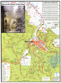
Map (Item) - Pocket map, Rooftop Mapping Services, Rooftop's Marysville Walks Pocket Map, 01-2009
A pocket map of ten walking tracks in an around Marysville. This map was published by Rooftop Mapping Services in January 2009.A pocket map of ten walking tracks in an around Marysville.marysville, victoria, australia, rooftop mapping services, steavenson falls, steavenson falls car park walk, beauty spot walk, marysville to el kanah guest house walk, gilberts gully walk, michaeldene track, man 'o' war walk, tree fern gully walk, marysville to woods lookout to mount gordon walk, keppels lookout walk -
 Marysville & District Historical Society
Photograph (item) - Colour photograph, Pre 2009
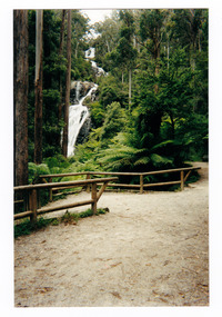
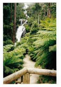
A colour photograph of the walking track leading to Steavenson Falls in Marysville in Victoria.A colour photograph of the walking track leading to Steavenson Falls in Marysville in Victoria. The Steavenson Falls is named after the Victorian Assistant Commissioner of Roads and Bridges, John Steavenson who arrived in Victoria in the early 1860s.Munroesteavenson falls, waterfalls, marysville, victoria, john steavenson -
 Marysville & District Historical Society
Photograph (item) - Colour photograph, Pre 2009
A colour photograph of the walking track leading to Steavenson Falls in Marysville in Victoria.A colour photograph of the walking track leading to Steavenson Falls in Marysville in Victoria. The Steavenson Falls is named after the Victorian Assistant Commissioner of Roads and Bridges, John Steavenson who arrived in Victoria in the early 1860s.Munroesteavenson falls, waterfalls, marysville, victoria, john steavenson -
 Marysville & District Historical Society
Painting (Item) - Watercolour painting, Miss I.K. Higgins, Michael Dene, Marysvile, Victoria, c1920
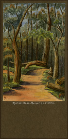
A watercolour painting of the Michael Dene walking track in Marysville in Victoria.A watercolour painting of the Michael Dene walking track in Marysville in Victoria by a Miss I.K. Higgins of Geelong in 1920. The Michaeldene Trail to Taggerty River Lookout is a 4.3 kilometer lightly trafficked loop trail located near Marysville, Victoria. The track is one of several walking tracks located in and around Marysville in Victoria.Michael.Dene.Marysville.Victoria Donated / by/ Elsie Stephens/ Mornington Painted by/ Miss I.K. Higgins/ of Geelong/ cc. 1920michael dene walking track, marysville, victoria, i.k. higgins, taggerty river -
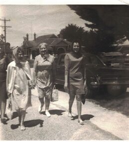 Linton and District Historical Society Inc
Photograph, Fundraising walk for Community Aid Abroad, 1968
Photograph shows Lintonians Mrs Hiscock, Carrie Murrell, Anne O'Beirne and Jennie Hiscock on a fundraising walk for Community Aid Abroad, November 20th 1968.Black and white photograph of four women walking along Clyde Street, Linton. Catholic Presbytery in background."Snap taken by Mr Frank O'Beirne Treasurer for "Community Aid Abroad" Nov. 20th 1968, Carrie Murrell, Anne O'Beirne and Jennie (Hiscock) Hocking walking for 'Walk want for C.A.A. (8 miles) 1968".carrie murrell, anne o'beirne, jennie hocking, jennie hiscock -
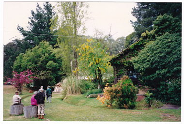 Marysville & District Historical Society
Photograph (item) - Colour photograph, 10-1993
A colour photograph of an unknown group of people walking through the gardens at Mountain Lodge in Marysville. The photograph was taken in October, 1993.A colour photograph of an unknown group of people walking through the gardens at Mountain Lodge in Marysville. The photograph was taken in October, 1993.Mountain Lodge - Marysville - Oct. '93marysville, victoria, australia, mountain lodge, accommodation, photograph, croquet -
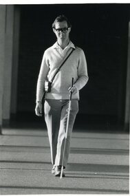 Vision Australia
Photograph - Image, Andrew with his sonic guide and white cane, 1987
Andrew walks along an external building verandah using a sonic guide and white cane.1 x B/W photograph of man walking with assistive devicesFile: Skills Training - O&M A white cane provides blind people with early warning of obstacles. (Andrew is also wearing a sonic guide in glasses.) Walking with the aid of sonic guide glasses. Technology for blind people at the Royal Blind Society. Credit: Rankin/1987royal blind society of new south wales, white cane day -
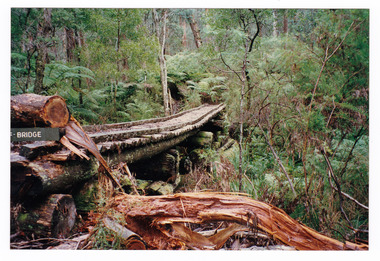 Marysville & District Historical Society
Photograph (item) - Colour photograph, 1996
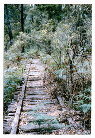
A colour photograph of the timber tramway bridge along the Michaeldene Walking Track near Marysville in Victoria.A colour photograph of the timber tramway bridge along the Michaeldene Walking Track near Marysville in Victoria. The Michaeldene Trail to Taggerty River Lookout is a 4.3 kilometer lightly trafficked loop trail located near Marysville, Victoria. The track is one of several walking tracks located in and around Marysville in Victoria.1996timber tramway, michaeldene walking track, marysville, victoria, walking track -
 Hume City Civic Collection
Photograph, c1920s
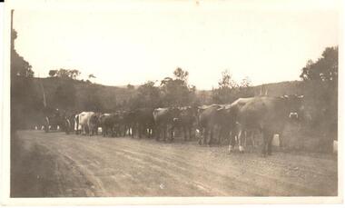
This image is of a bullock team belonging to Mr. Camm at Rupertswood. There are two men in the dray and one man in a white coat walkingA black and white photograph of a bullock team belonging to Mr. Camm. There are two men in the dray and one man in a white coat walking.animals, livestock, men, bullocks, camm, - (mr), rupertswood, drays, george evans collection -
 Marysville & District Historical Society
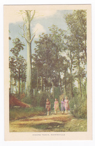
Postcard (item) - Colour tinted postcard, Nucolorvue Productions, Hikers Track, Marysville, c1950s
An early colour photograph of a group of ladies walking along a track in Marysville in Victoria.An early colour tinted potograph of a group of ladies walking along a track in Marysville in Victoria. This postcard was produced by Nucolorvue Productions in Elwood, Victoria as a souvenir of Marysville.POST CARD NUCOLORVUE PRODUCTIONS, ELWOOD, VICTORIAwalking track, marysville, victoria, nucolorvue productions, postcard, souvenir -
 Tatura Irrigation & Wartime Camps Museum
Photograph, Hogan Street, Tatura
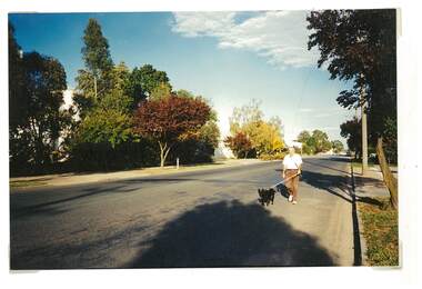
Shows picture of a man walking his dog down Hogan Street, Tatura, near Tatura Milk. Looking west along Hogan Street. Sepia photograph showing man walking a dog near Tatura Milk, Hogan Street, Tatura. Photograph stuck onto piece of white cardboard. tatura victoria, hogan street tatura -
 Marysville & District Historical Society
Photograph (item) - Colour photograph, 01-1964
A colour photograph of the timber tramway bridge along the Michaeldene Walking Track near Marysville in Victoria.A colour photograph of the timber tramway bridge along the Michaeldene Walking Track near Marysville in Victoria. The Michaeldene Trail to Taggerty River Lookout is a 4.3 kilometer lightly trafficked loop trail located near Marysville, Victoria. The track is one of several walking tracks located in and around Marysville in Victoria.MARYSVILLE JANUARY 1964timber tramway, michaeldene walking track, marysville, victoria, walking track -
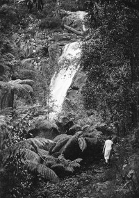 Marysville & District Historical Society
Photograph (item) - Black and white photograph, Unknown
A black and white photograph which shows a woman walking along the track that leads to the base of Steavenson Falls.A black and white photograph which shows a woman walking along the track that leads to the base of Steavenson Falls. The Steavenson Falls is named after the Victorian Assistant Commissioner of Roads and Bridges, John Steavenson who arrived in Victoria in the early 1860s.steavenson falls, marysville, victoria, waterfalls -
 Whitehorse Historical Society Inc.
Article, Many Questions on Land, 1/09/2014 12:00:00 AM
The Victorian State Governme.nt will protect 2 parcels of land totalling 15.4 ha. of the Healesville Freeway Reservation as Crown Land.The Victorian State Government will protect 2 parcels of land totalling 15.4 ha. of the Healesville Freeway Reservation as Crown Land and the planned walking and cycling path, running it's entire length, will go ahead.The Victorian State Governme.nt will protect 2 parcels of land totalling 15.4 ha. of the Healesville Freeway Reservation as Crown Land.healesville freeway reservation, cycling path, walkinig path -
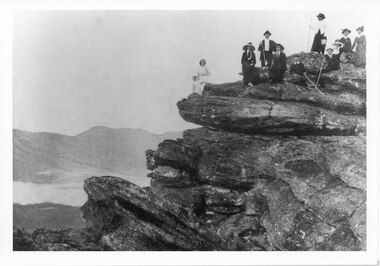 Halls Gap & Grampians Historical Society
Photograph - B/W
A walking group on an outcrop in the Grampians.The photo shows a group of ten people, seven women wearing long dresses, a man wearing dark trousers and jacket, a light coloured shirt and a hat, and two boys wearing dark clothes and caps, posed on a rocky outcrop/lookout. A number of people in the party are carrying long walking sticks. In the background another range can be seen across a valleyscenery, lookouts -
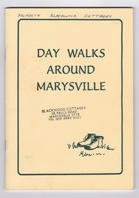
 Marysville & District Historical Society
Booklet - Paperback booklet, Maroondah Bushwalking Club Inc, Day Walks Around Marysville, 1996
A booklet outlining day walks of various difficulties in and around the surrounds of Marysville.Paperback booklet. Front cover shows title with a cartoon drawing of a pair of walking boots. Back cover shows details of the publisher and distributor of the publication.non-fictionA booklet outlining day walks of various difficulties in and around the surrounds of Marysville.marysville, victoria, day walks, bushwalking, maroondah bushwalking club, cathedral range, sugarloaf peak, neds gully, maroondah highway, woods lookout, cement creek, acheron, lake mountain, snowy hill, cumberland reserve, wilks creek, mount strickland, the beeches, mount margaret, stevensons falls, steavensons falls, de la rue lookout, oxlee lookout, keppel lookout, keppel hut, north jawbone peak, cumberland scenic reserve, acheron road, buxton, man o war track, phantom falls, keppel falls, athols abbey, sunds road, trestle track, booklet -
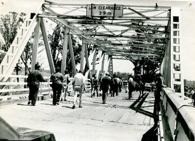 Orbost & District Historical Society
black and white photograph, 1976
This bridge over the Snowy River was opened on July 4 1922. It was constructed in 1922 alongside the previous suspension bridge. Its building was a combined effort of the Victorian Railways and the Country Roads Board at a cost of 35,000 pounds. It was replaced in 1976 by the present bridge after several major floods. This photograph shows people walking over the bridge for the last time.This is a pictorial record of the former Snowy River Bridge at Orbost.A black / white photograph showing a group of people walking across a bridge. There are several cars, a man on a horse and people standing on the side of the roadway.on back - "1976 - old bridge"snowy-river-bridge-1976 -
Whitehorse Historical Society Inc.
Letter - Correspondence, Yarran Dheran, 17/01/1979 12:00:00 AM
Letter from Yarran Dheran Committee of Management to Town Clerk, Nunawading 17/1/1979.Letter from Yarran Dheran Committee of Management to Town Clerk, Nunawading 17/1/1979 regarding walking and bicycle tracks between Schwerkolt Cottage and Yarran Dheran. With letter from Ann Creber to George Cox regarding meeting on the subject.Letter from Yarran Dheran Committee of Management to Town Clerk, Nunawading 17/1/1979.yarran dheran, parks and reserves, schwerkolt cottage, walking trails, bicycle paths -
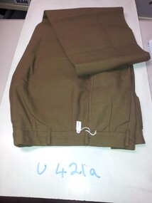
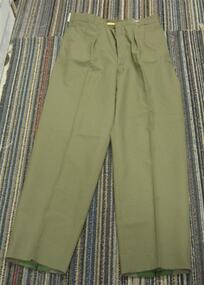 Running Rabbits Military Museum operated by the Upwey Belgrave RSL Sub Branch
Trousers - Poly
Walking Outuniform, c1960, army -
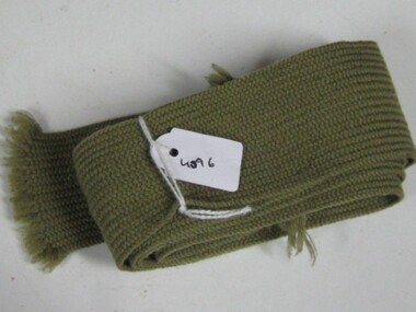 Running Rabbits Military Museum operated by the Upwey Belgrave RSL Sub Branch
Tie
Walking Outuniform, c1960, army -
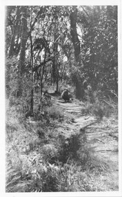 Halls Gap & Grampians Historical Society
Photograph - B/W
Photo shows a sheep on Zumstein's/MacKenzie Falls track 1925Sheep on Zumstein McKenzie Falls walking track / Stan Parfettaccess routes, walking track -
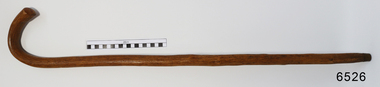 Flagstaff Hill Maritime Museum and Village
Accessory - Walking Stick, William Dale, early 1900's
In the words of the Donor, Betty Stone, "This walking stick was made by William Dale from wood obtained from his property Bluestone Quarries situated at Wangoom, Warrnambool. William Dale, the son of William Booth and Hannah (nee Broadbent) Dale was born on 8 July 1828 in Saddleworth, Yorkshire, England. He emigrated to Australia in 1852 and seven years later purchased twenty acres of land in the shire of Wangoom, Warrnambool where he operated a quarry known as The Dale Bluestone Quarries. According to family legend, when William and his wife Elizabeth (nee Chamberlain) first moved into their bluestone cottage on the property, it was surrounded by dense bush that abounded with wildlife. William Dale used this walking stick in his later years. Although physically bent after years of toil, his grandchildren remembered him wheeling his barrow and walking with his stick around the quarries when aged well over eighty years. William Dale died at his residence on 14 December 1913 aged 85 years." (Note: For additional information please refer to Betty Stone’s book “Pioneers and Places - A History of three Warrnambool Pioneering Families” ie. Chamberlain, Dale and Lees Families) This item is associated with the families of Chamberlain, Dale and Lees. These families are listed in the "Pioneers' Register" for Warrnambool Township and Shire, 1835-1900, published by A.I.G.S. Warrnambool Branch. The handmade walking stick was made from local resources.Walking Stick, polished wood with grain and knots showing. Brass tip, 'J' shaped handle. Made by William Dale in the early 1900's of wood from his property, "Dale Bluestone Quarries", Wangoom, Warrnambool. From the 'Chamberlain Dale and Lees Collection'.flagstaff hill, warrnaflagstaff hill, warrnambool, shipwrecked coast, flagstaff hill maritime museum, maritime museum, shipwreck coast, flagstaff hill maritime village, great ocean road, chamberlain, dale, lees, stone, betty stone, warrnambool pioneers, mbool, shipwrecked-coast, flagstaff-hill, flagstaff-hill-maritime-museum, maritime-museum, shipwreck-coast, flagstaff-hill-maritime-village, dale bluestone quarries, william dale, walking aid, walking stick, mobility aid -
Tatura Irrigation & Wartime Camps Museum
Photograph, Goulburn-Waranga Channel, 1957
Taken by the photographer for Victoria State Rivers and Water Supply Commission.Large sepia photograph Dragline left of centre, with scoop bucket in action, right of centire, two men left of dragline cabin - wall of earth in foreground.Above photo: "Goulburn - Waranga Channel / Bucyrus 200W Walking Dragline"irrigation, goulburn, victoria state rivers and water supply commission, channel, dragline, bucyrus 200w -
Running Rabbits Military Museum operated by the Upwey Belgrave RSL Sub Branch
Uniform Complete
RAAF "walking out" uniformmodel, 1970, raaf -
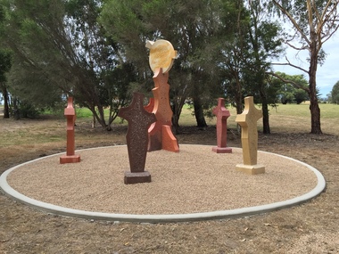 Federation University Art Collection
Sculpture, 'Mungo Moon' by Don Barrett, 2015
'Mungo Moon' by Don Barrett is the first sculpture erected on the Churchill Art and Culture Pathway. It was officially unveiled by Professor David Battersby on 15 April 2015 From Churchill & District News 16 October 2014 The Churchill Art and Culture Walking Pathway will have its official public opening on Saturday October 18, with a walk finishing at Federation University Australia’s Switchback Gallery at the Federation University Gippsland Campus. ... An important link on the newly developed pathway was recently completed with a path south of the FedUni Student West Residences. The path now allows walkers to turn off the Eel Hole Creek path before reaching Glendonald Estate and to follow a picturesque, tree lined walkway to join up with the footpath on the Eastern side of Northways Road. From there the footpath joins into Federation University’s network of walking paths that proceeds past the Switchback Art Gallery, down through the pine plantation and along Lake Kretlow and the Churchill Golf Course. Project Manager Mike Answerth, said the opening of the West Residences section of the path means there is now only one short link to complete. “We’re now very close to realising the project’s objective to join up all these walking paths to provide a continuous pathway that encompasses town, campus and parkland. The next stage of the project will be the completion of Latrobe City’s East West Link and the enhancement of the walking path with artistic and cultural features.” said Mr. Answerth. Head of Federation University Australia Gippsland Campus, Dr Harry Ballis, said the project had been made possible through the contributions of the five former Gippsland Education Precinct (GEP) partners. “The Art and Culture Pathway represents another important step in joining the Churchill township and the university campus as a physical and social entity,” Dr Ballis said. “This was an initiative of the GEP and it is pleasing to see it coming to fruition.” The path now reaches as far as the golf driving range but plans are already under way to connect with the Mathison Park board walk and pathway, which surrounds Lake Hyland in Churchill. When the loop is completed, residents and visitors will have an approximately 5km circular walking path which links up the Churchill town centre, Federation University Australia and Mathison Park. There are already art features along this route, including primary schools’ Bug Blitz totems near the Kurnai College school crossing, native vegetation and history panels near the Hare Homestead in Mathison Park, and outdoor sculptures in the pine trees near the Federation University Switchback Gallery. contemporaryA large sculpture in five pieces set in an external location. It is part of the Churchill Art and Culture Walking Pathway. Don Barrett’s work is mainly in concrete with added coloured oxides to portray the feeling of the Australian landscape. Barrett focuses on concepts of Australia’s short history and indigenous history. churchill art and culture pathway, barrett, don barrett, gippsland campus, federation university, churchill, sculpture -
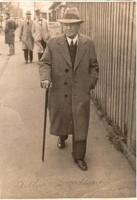 Hume City Civic Collection
Photograph
A b/w photograph of a male, Arthur Boardman wearing overcoat and hat, walking stick in hand walking along footpath.Handwritten on front: Arthur Boardman Handwritten on back: ARTHUR BOARDMAN / 18 Boardman / WQ23-8 Stamped on back: LEICAGRAPH PTY LTD / 210 FLINDERS LANE / MELBOURNEboardman, arthur, leicagraph pty ltd, portraits, males, clothing and dress, george evans collection -
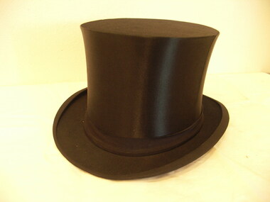 Friends of Westgarthtown
Top hat
Worn by Pastor Steiniger. Collapsible black top hat, leather band inside, lined.gold symbol of man walking on globe in top hat on inside top of hat.costume, male headwear, pastor, top hat, lutheran, steiniger -
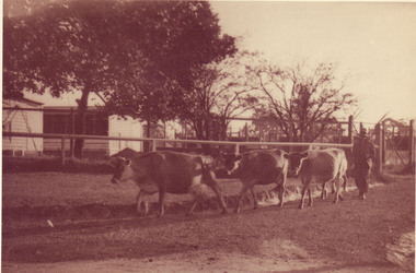 University of Melbourne, Burnley Campus Archives
Photograph - Sepia print, Jersey Cows, Unknown
Note associated with this photograph, "Removed from Record Book (B91.453) labelled, 'Stock Breeding Record,' Purple and Black [cows.]" Note by T.H. Kneen 8 April 1992, "Jersey cows moving from pastures at west end of property past the Egg-Laying Competition pens, heading for the milking shed."Sepia photograph. 3 jersey cows walking beside a fence with egg laying pens behind. Man walking behind them.stock breeding record, cows, jersey cows, egg-laying competition, dairy, lagoon paddock, milking shed, poultry pens, stockman -
 Running Rabbits Military Museum operated by the Upwey Belgrave RSL Sub Branch
Trousers - Dress
Army Trousers Dress Walking Outuniform, 1966, army