Showing 165 items
matching water crossing
-
 Eltham District Historical Society Inc
Photograph, Sign to Hume and Hovell Cricket Ground, at Allandale Road, Strath Creek, Autumn Excursion, Hume and Hovell's 1824 expedition, 26 May 1996, 26/05/1996
[article by Bettina Woodburn in EDHS Newsletter No. 109, July 1996:] ON THE TRAIL OF HUME AND HOVELL - REPORT ON THE AUTUMN EXCURSION - On a green and fresh morning (Sunday 26th May 1996) the Cobb and Co coach (driven by the most obliging Peter Tampion) set off in a north easterly direction from Eltham to connect with Hume and Hovell's route on their 1824 explorations of central Victoria. The Society would follow a series of monuments erected for the 1924 centenary of the expedition from King Parrot Creek (Tuesday 7th December 1824), through Strath Creek, over Sunday Creek (Sunday 12th December 1824) at Broadford, Tullamarine, St Albans, Deer Park, through Werribee, skirting east of the You Yangs to Lara and Avalon Beach. Because their distance-measuring wheel had broken and a one degree mistake was made in calculations, the two leaders of the original group of six convict-companions arrived at Corio Bay, instead of the expected Western Port, discovered earlier by Flinders. From below Mt. Disappointment (Hume and Hovell's difficulties in "scrambling over brush and rock", "leeches in forest, as well as no water", "cutting grass 4-5 ft. high", dreadful scrub", "devil flies") we took an easier route, saw the Strath Creek memorial in ground fog and a wonderful "field of dreams", the Hume-Hovell privately owned cricket ground with its white picket boundary fence. Now, after a steep climb, in sunshine under gums we stretched and viewed magnificent rolling hills and fog-filled valleys - not "smoke from Aborigines' bush fires". After morning tea at Broadford we followed the Sunday Creek valley beside the Hume Freeway, passed the Wallan Wallan Rest Area (more appropriately Hume and Hovell Rest Area) to tum right at Beveridge. In Gellibrand Hill Park, near the headwaters of the Moonee Ponds Creek, we experienced the landscape the first European settlers saw - huge river red gums and rolling pastures. The gardens and sheltered courtyard of the 1840s, timber, brought from .....[?] prefabricated Woodlands Homestead, provided a pleasant lunch stop. We enjoyed a private tour, panoramic views over Melbourne and surroundings and the excitement of arriving and departing aircraft. Our next river crossing was at Werribee, "in a vast treeless plain", then we drove on by-ways no coach had previously travelled, to find "an immense sheet of water" salty Corio Bay, off-course to the west. In late afternoon of a super, calm, late autumn day we headed homewards. Back at Eltham we were rather surprised to find that we had travelled a total of 347 km. Thanks again to Russell Yeoman for his research and organization. What a wonderful day! Colour photographactivities, hume and hovell, allandale road, strath creek -
 Eltham District Historical Society Inc
Photograph, Autumn Excursion, Hume and Hovell's 1824 expedition, 26 May 1996, 26/05/1996
[article by Bettina Woodburn in EDHS Newsletter No. 109, July 1996:] ON THE TRAIL OF HUME AND HOVELL - REPORT ON THE AUTUMN EXCURSION - On a green and fresh morning (Sunday 26th May 1996) the Cobb and Co coach (driven by the most obliging Peter Tampion) set off in a north easterly direction from Eltham to connect with Hume and Hovell's route on their 1824 explorations of central Victoria. The Society would follow a series of monuments erected for the 1924 centenary of the expedition from King Parrot Creek (Tuesday 7th December 1824), through Strath Creek, over Sunday Creek (Sunday 12th December 1824) at Broadford, Tullamarine, St Albans, Deer Park, through Werribee, skirting east of the You Yangs to Lara and Avalon Beach. Because their distance-measuring wheel had broken and a one degree mistake was made in calculations, the two leaders of the original group of six convict-companions arrived at Corio Bay, instead of the expected Western Port, discovered earlier by Flinders. From below Mt. Disappointment (Hume and Hovell's difficulties in "scrambling over brush and rock", "leeches in forest, as well as no water", "cutting grass 4-5 ft. high", dreadful scrub", "devil flies") we took an easier route, saw the Strath Creek memorial in ground fog and a wonderful "field of dreams", the Hume-Hovell privately owned cricket ground with its white picket boundary fence. Now, after a steep climb, in sunshine under gums we stretched and viewed magnificent rolling hills and fog-filled valleys - not "smoke from Aborigines' bush fires". After morning tea at Broadford we followed the Sunday Creek valley beside the Hume Freeway, passed the Wallan Wallan Rest Area (more appropriately Hume and Hovell Rest Area) to tum right at Beveridge. In Gellibrand Hill Park, near the headwaters of the Moonee Ponds Creek, we experienced the landscape the first European settlers saw - huge river red gums and rolling pastures. The gardens and sheltered courtyard of the 1840s, timber, brought from .....[?] prefabricated Woodlands Homestead, provided a pleasant lunch stop. We enjoyed a private tour, panoramic views over Melbourne and surroundings and the excitement of arriving and departing aircraft. Our next river crossing was at Werribee, "in a vast treeless plain", then we drove on by-ways no coach had previously travelled, to find "an immense sheet of water" salty Corio Bay, off-course to the west. In late afternoon of a super, calm, late autumn day we headed homewards. Back at Eltham we were rather surprised to find that we had travelled a total of 347 km. Thanks again to Russell Yeoman for his research and organization. What a wonderful day! Colour photographactivities, hume and hovell -
 Federation University Historical Collection
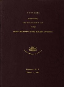
book, Truth & Sportsman Ltd, Souvenir commemorating the commencement of work by the Snowy mountains hydro-electric authority, 17/10/1949
It is assumed that a member of the Ballarat School of Mines attended the commencement of work at the Snowy Mountains hydro-electric centre.Burgundy cover with gold printing. Black print, photos and diagrams on white paper (31 pages). Bound by 3 staples. The contents include the story of the Snowy. Images include W.J. McKell, J.B. (Ben) Chifley, J. McGirr, Nelson Lemmon, Hume Weir, Jindabyne valley (now flooded), Jindabyne township (now flooded), illustration of water Power, survey team at Adaminaby, Snowy Mountains Relief Plan, Horseman crossing the Eucumbene River, Mildura, Burrinjuck Dam under construction, transmission lines, W. Hudson.snowy mountains hydro-electricty scheme, snowy mountains hydro-electric authority -
 Federation University Historical Collection
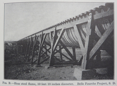
Book, Irrigation Practice and Engineering Volume 2: Conveyance of Water and Volume 3: Irrigation Structures and Distribution System by B.A. Etchevery, 1915 and 1916
Blue hard covered books. .2) Volume III Irrrigation Structures and Distrubution Systemirrigation, water canals, tunnels, flumes, pipes, concrete pipes, wrought iron and steel pipes, wooden pipes, california, diversion works, weirs, spillways, canals, check gates, railroad crossing, america, united states of america, university of california, yellowstone river, colorado, arizona, windlass hoist, twin falls, idaho, arkansas valley, truckee-carson, salmon river, umatilla, cippoletti weir box -
 Flagstaff Hill Maritime Museum and Village
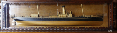
Craft - Ship Model, S.S. Nelson, 1877 - 1984
This beautifully made ship model is a side relief of the steam ship “S.S. Nelson”, which was launched in 1877. The model’s case stands out because of its ornately carved internal frame. Relief models of ships, sometimes called half models, were often built by the shipbuilders as an exact scale model of the finished ship. The shipbuilders would use the model to ensure that the design was balanced. They would use the model as a point of reference during building. Also, ship models were used to demonstrate the designs to prospective buyers. It is not known whether this model of the “S.S. Nelson” was made for these purposes. HISTORY of the “S.S. Nelson” During the period 1840-1890 shipping was the cheapest and most practical means of carrying produce and goods to and from coastal towns such as Warrnambool. In the 1850s regular domestic steamer services began and by 1870 the passenger trade was booming. Passengers were taken to the ship’s side in small boats called lighters, which took it to ships at anchorage in Lady Bay, then climbed aboard up ladders or gangways. Their fare covered accommodation Saloon/Cabin section (higher class and more expensive) or the Steerage section (lower class and less expensive, below deck level). Produce included livestock such as pigs and fowls, and dairy products, bales of wool, and potatoes. The goods were loaded from the Warrnambool Jetty into the lighters. The S.S. Nelson was built by Messrs Blackwood and Gordon of Port Glasgow for a cost £25,000 in 1877. She was an iron screw steamer with an overall length of 200 feet, beam 25.5 feet and a depth of hold of 19.4 feet, which gave her a gross measurement of 649 tons. Her engines gave her a best speed of 13 knots and a maintainable speed of 12 knots. She was described as a handsome, star decked, efficient steamship, fitted with accommodating for 75 first class passengers in a saloon, and 40 second class passengers in a cabin. The S.S. Nelson arrived in the colony of Victoria on March 9th, 1877. She was first registered in Warrnambool by the Warrnambool Steam Packet Company under the management of Mr William Evans, and employed in the coastal trade of south west Victoria. She was very popular in 1878, registered under the new ownership of the Western Steamship Navigation Company, trading between Melbourne, Warrnambool and Portland. Captained John Nicholson commanded the S.S. Nelson after the previous captain, Thomas Smith, was suspended in 1882 for six months by the Victorian Steam Navigation Board following the collision between the S.S. Nelson and the S.S. Julia Percy. Other Captains include S Drewet and John Thompson. The S.S. Nelson was sold to Messrs. Huddart, Parker and Co. and re-registered in Melbourne on June 23rd, 1890. The new owners intended to use her for their Bass Strait crossing between Melbourne, Victoria and Launceston, Tasmania. On the night of Friday, June 27th 1890, under the command of Captain Carrington, she was on her way to Launceston on her first crossing for her new owners. She had no passengers and very little cargo and was to return to Melbourne with passengers the following morning. She was only 21 hours out of the dock when she struck Porpoise Rock in the Tamar River. All crew of 25 were saved but the bulkheads gave way and she rapidly filled before keeling over and disappearing in approximately 130 feet of water. The new owners had fully insured the almost 14-year-old S.S. Nelson with the Australian Alliance Insurance Company and she had only been in their possession for four days. This ship model of the S.S. Nelson is significant for its connection with the steam screw ship S.S. Nelson, one of a fleet of vessels owned by the Warrnambool Steam Packet Company. The S.S. Nelson was specifically built and purchased for the Victorian coastal trade business of the late 19th century, when shipping was the cheapest and most practical means of transporting goods and passengers between Victoria’s coastal towns and the major port at Melbourne. Once the railway came to Warrnambool in 1889, the steam shipping industry began to decline.Ship model; relief of the S.S. Nelson, showing deck superstructure, ventilators and single funnel. Ship's name is painted on the bow "NELSON". Wood model, varnished finish over natural wood and black painted areas. Timber case with ornate edging and glass front and sides."NELSON" painted on bowflagstaff hill, warrnambool, shipwrecked-coast, flagstaff-hill, flagstaff-hill-maritime-museum, maritime-museum, shipwreck-coast, flagstaff-hill-maritime-village, s.s. nelson steam ship 1877, screw steamer, 1877 vessel, ship model s.s. nelson, blackwood and gordon port glasgow, warrnambool steam packet company, western steam navigation company, south west coast trader, sea transport melbourne to portland, victorian steam navigation board, s.s. julia percey, captain john nicholson, captain thomas smith, captain s drewet, captain john thompson, captain carrington, huddart, parker and co, bass strait crossing 1890, sea transport melbourne to launceston, porpoise rock tamar river, australian alliance insurance company, ship model making, vessels, victorian coastal trader -
 Yarra Glen & District Historical Society
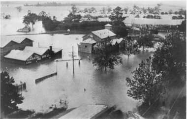
Black and white photographs, Flood waters in Yarra Glen December 1934
Black and white photograph of Bell street, Yarra Glen, taken in December 1934 from the tower of the Grand Hotel, looking south towards the railway crossing, during the floods. The Victoria Hall is the building in the centre of the photograph. Directly behind the Victoria Hall, the roof of 'River View' guest house can be seen. The Shell Garage, operated by Les Orenshaw, on the left of the photograph was originally built and occupied as a peg factory.The view extends from Bell street across the river flats with the high ground of Chateau Yering in the background. Bell Street is defined by the street trees where the water covers the road in the foreground grand hotel, victoria hall, bell street, floods 1934, 1934 flood, railway crossing, river view, guest house, shell garage, peg factory, river flats, chateau yering, les orenshaw, street trees -
 Federation University Historical Collection
Book, The Old Pioneers' Memorial History of Melbourne From the Discovery of Port Phillip to the World War, 1924
Blue hard covered book of 494 pages. Images, and a large plan of prominent burials in the Melbourne Old Cemetery, and a Map of Melbourne. melbourne, melbourne cemetery, melbourne old cemetery, john batman, edmund hobson, batman's map, st francis' church, james balfour, mrs hornbrook, paddy's market, wilson hall, working men's college, henry kendall, le souef's cottage, world war one, westernport, melbourne cup, hoddle, collingwood, south melbourne, prahran, richmond, kew, brunswick, coburg, preston, hawthorn, camberwell, nunawading, doncaster, st kilda, brighton, sandringham, cheltenham, caulfield, oalkleigh, footscray, sunshine, north melbourne, carlton, ballarat school of art library, ballarat technical art school, book plate, library plate, hume and hovell's overland journey 1824-5, major mtichell's overland journey, australia felix, booplate, aborigine, aboriginal, captain cook, arthur phillip, isaac smith, george bass, matthew flinders, john murray, catain baudain, captain collins, edward henty, portalnd, map od melbourne in 1938, john pascoe fawkner, the "enterprise: and fawkner's first home, old colonists' homes, rushall crescent north fitszroy, richard bourke, the old melbourne post offfice, old governmnt house, toorak, latrobe's house at jolimont, first melbourne land sale, melbourne water supply, peter henry smith, victorian legislative council opening, map of melbourne and collingwood, prince's bridge, crossing the rivers by punt, f.a> rucker, canvas city emerald hill, arrival of the gold escort in melbourne, the yarra, queen's wharf, tall ships, old st james, mary e. budd, st francis church, michael carr, meolbourne city mission, state library of victoria, melbourne public library, bourke street, angus mcmilan, methodist ladies college, ormond college, armistance celebrations, robert russell, mia mia, theatre royal bouke st, melbourne from flaggstaff hill, federal coffee palace collins st, lord melbourne, melbourne mint, old melbourne town hall, robert russell's melbourne and yarra falls, mandevalle hall, point lansdale lighthouse, wilson's promontory, margaret m. ward cole, williamstown, flinders st melbourne, queenscliff battery, broadmeadows soldiers' camp, embarkation of first troops on the 'ceramic', general monsash, ian hamilton, general bridges, victorian war memorial, national war memorial, st kilda pier, first melbourne cup, hoddle's grid, albert park, melbourne mechanic's institute, st kilda toll gate, munted policeman, springthorpe memorial, james bonwick, mornane's paddock, victorian railways melbourne and surburban lines, carlton gardens, thomas napier, wiliam westgarth, george augustus robinson, william lonsdale, elizabeth mary batman, peomena frances darling batman, dig tree, exhibition of 1854, exhibition of 1866, exhibition buildings, geelong harbour, jubilee lake, port campbell, warrnambool, queenscliff lightboat, batman's first house -
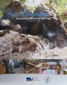 Federation University Historical Collection
Book, Department of Sustainability and Environment et al, Spa Country: Victoria's Mineral Springs, 2010, 2010
Soft covered book of 32 pages. Includes information of Victoria's mineral water springs.spa coutnry, mineral water, mineral springs, bottles, bottling, cans, ballan, blackwood, daylesford, central springs, sailor's falls, deep breek, glenlyon, woolnoughs crossing, hepburn springs, locarno spring, pavilion spring, swiss and italians, argyle spring, geology, kyneton, taradale, leitches creek, spargo creek, carroll's mineral spring, vaughan, glenluce, geelong, eastern beach mineral spring, hepburn democratic club, macaroni factory -
 Tatura Irrigation & Wartime Camps Museum
Photograph, Cattanach Canal, 1957
Taken by the photographer for Victoria State Rivers and Water Supply Commission.Large sepia photograph - Construction equipment middle foreground, two bridges, truck crossing second bridge, trees, flat paddock, scattered trees, man working on nearer concrete bridge support.Below photo: "Cattanach Canal / Rail and Highway Bridges near Murchison"irrigation, victoria state rivers and water supply commission, cattanach canal, bridges -
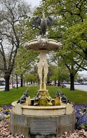 City of Ballarat
Artwork, other - Public Artwork, Petersen Fountain, 1922
This fountain was created as the result of a bequest from Ballarat businessman Carsten Heinrich Petersen who was killed at the age of eighty-five years when crossing Sturt Street opposite the Base Hospital. On the other side of the street were three brick shops which he owned. The fountain has four bronze frog water spouts beneath four marble stork spouts. Above the top bowl is another stork in bronze with its wings spread and water issues from its outstretched beak. The Petersen Fountain has been restored many times, first in 1977 with funds provided by the Rotary Club of Ballarat South. In 1989 further restoration works were completed to replace bronze frogs and a brass and copper stork made by Ballarat craftsman Lloyd Lusk to replace the original bird which was stolen and never recovered. The second stork was also stolen on the 3rd of August 1983 and further repairs of the fountain were carried out in 1993. The artwork is of historical and aesthetic significance to the people of Ballarat. The Petersen Fountain is carved marble, features storks carved into its base and the faces of cherubs in the bowl. It has a copper crane perched at the top and bronze frogs surrounding that spray water. The fountain stands on a granite base. PRESENTED/ BY/ C.H. PETERSEN/ BORN IN DENMARK 2nd MARCH 1836/ DIED BALLAARAT 9 FEBRUARY 1922petersen fountain -
 Hume City Civic Collection
Photograph, Early 1990's
The photograph was taken after Coles Supermarket and Sunbury Shopping Square were constructed on the railway land on the east side of the line in 1989, but before the Safeway-Woolworths complex was built in 2000 on the west side of the railway line. The open land on the west side of the line was used by rail communters as a car park.A coloured photograph showing part of the T intersection at Cornish and Horne Streets. A large pine tree is growing at the corner immediately in front of a pedestrian crossing. The railway car park, metal water tower and Coles Supermarket are in the background. A boy is walking along the footpath.cornish street, horne street, water towers, coles supermarket, sunbury railway station, george evans collection -
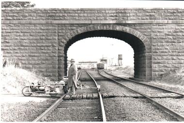 Hume City Civic Collection
Photograph, Pre 1989
The bluestone 'road over rail' bridge at Macedon Street is of state architectural, architectural, historical and engineering significance. It spans the first government regional railway. Its design and building was done according to strict English standards and made use of a bridge crossing instead of a level road crossing.A black and white photograph of a stone bridge with an eliptical arch spanning two rail tracks. A workman is standing between one set of tracks in the foreground and a railcart is next to the tracks. The station, footbridge and water tower are visible through the arch.road over rail bridge, bridges, sunbury railway station, water towers, pedestrian bridges, stone bridges, george evans collection -
 Sunshine and District Historical Society Incorporated
Photographs (1928), 'QUARTER MILE' BRIDGE Construction, 1928
One man lost his life during the building of this bridge. The bridge was constructed by the Victorian Railways between 1927 to 1929 to carry a new double track goods line. This enabled trains from all parts of the state except Gippsland to have direct access to the Tottenham marshalling and sorting yards. These yards were constructed in the 1920's to relieve congestion in the Melbourne Yard near Spencer Street station. The congestion was being caused by the construction of suburban passenger platforms associated with the electrification of the suburban railway network. Initially the bridge was for goods trains but during the Second World War it was also used by troop trains. When the standard gauge line was built in 1962 all trains to Albury and Sydney have used this route, thus avoiding travelling through Essendon and Pascoe Vale on the suburban tracks. The standard gauge track across the bridge took the place of one of the broad gauge tracks so broad gauge trains crossing the bridge in either direction have to now use the same track. The bridge is 1,257 feet (383.13 metres) long and 180 feet (54.86 metres) above the water level. It is just 63 feet (19.2 metres) short of a quarter mile in length between abutments. There is a similar bridge on the same railway line crossing the Moonee Ponds Creek between Gowenbrae and Glenroy, however it is smaller at 1060 feet (323.08 metres) length and 115 feet (35.05) height.The bridge is now Victorian Heritage Registered under Number: H1197, and Heritage Overlay Numbers HO5, and HO107. On the Heritage Register it is named RAIL BRIDGE (ALBION VIADUCT). According to the Heritage Report the bridge is scientifically and architecturally important because of its large size, and because of the cost effective design features such as two girders per span (one for each track), the K bracing in the towers, and the broad flange beams as columns. When it was being built it was the largest trestle bridge in Australia, and until the Sydney Harbour bridge was constructed it was the highest railway bridge.Five B&W yellowing photos showing stages of construction of the Maribyrnong River Viaduct known as the Trestle Bridge but mainly known locally as the QUARTER MILE BRIDGE. It is a railway only bridge which runs over the Maribyrnong River between Sunshine North and Keilor East. A sixth image, which is not part of this set of photos, is included to show what the completed bridge looks like. -
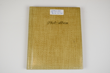 National Wool Museum
Photo Album, 1930-1934
The Photo Album was created by Hans Beck, who interned with the donor's father (Wilhelm Eckels). The Photo Album depicts wool buying and sheep station related life between 1927-1939. Each photograph has been individually labelled.Straw coloured booklet with gold cursive writing on front cover spelling 'Photo Album'. Inside are 18 pages containing 63 photographs, each individually captioned. Internal pages show signs of age with discolouration, particularly in areas of previous adhesive application.Lettering, Front: Historic Interest Before WME arrived - 1930-1934 Wool & Sheep Photo Album Lettering, Internal by Page: Page 1 - Bottom Left Conner: Table from right:/ O. Hilbert sen. / WW. Richter, W. Ehrig/ Sampler: C. McCarthy/ at desk: E.S. Bottom Right Corner: 1927/ Wool Sample Room/ O. Hilbert/ Terranora Buildings/ Reiby Lane Page 2 - Bottom Middle: 1931/ Opening Sale/ Sydney Page 3 - Bottom Middle: 1934/ Opening Sale/ Sydney Page 4 - Bottom Middle: 1933/ Wool Auctions/ Brisbane Page 5 - Top Left Corner: 1930 Escapade/ Sydney to CAIRNS/ via Bourke, Central/ Queensland, Hinter-/ land & Atherton/ Table Lands Top Right Corner: Dubbo: Main Street/ (1st Night)/ 31.7.1930 Middle Right: 1st Night-"OUT"/ Stranded 11 miles/ from Bourke. (Red/ Dust in Carburettor Bottom Right Corner: Our "ERSKINE'/ hits Culvert &/ breaks both King-/pins. 1 1/2 miles from/ CUNNAMULLA SW-Q. Page 6 - Top Right Corner: "Rosevale Station"/ via Cunnamulla SWQ/ "Gidgi" country/ Gidgi Creak &/ Warrigo R. Middle Left: STAN HILL Page 7 - Middle Top: Blackhall/ Tattersall's Hotel/ Yarning at Cross-/roads. Middle Left: FO Wool Sales/ 22 Horse team Middle Right: Roadsign to:/ ISIS DOWNS &/ Homestead (Fart Page 8 - Middle Top: Muster: 3000 sheep/ Semi-circular/ Shearing shed/ ISIS DOWNS Page 9 - Middle Top: Shearer/ Water Tower/ Counting out/ pens Middle Bottom: Shearers Cook/ Hot Water & Soup/ Cake for Shearing/ Shed Charity Ball Page 10 - Middle Left: Isis Downs Home-/ stead with fire// flood Lookout./ Artesian Borewell Bottom Right: Manager: Moore/ & Alfred Loh-/ mann with kills/ Ducks & Emus Page 11 - Top Middle: PORTLAND DOWNS/ Muster: 10,000/ Sheep Bottom Left: Manager:/ Mr. Luck/ with A.L./Moore Page 12 - Middle Top: ROOKWOOD Station/ near/ HUGHENDEN/ Central NWQ Page 13 - Top Middle: 'HINTERLAND"/ Cattle country/ Spear Grass/ Tracks Bottom Middle: Crossings:/ Creeks: Quick/ Sand/ Rivers: rocky Page 14 - Middle Right: Lyndhurst stat/tion/ Head Stockman Middle Left: -Valley of la-/goons/ Station Bottom Right Corner: Master Atkinson/ saves/ Petrol shortage Page 15 - Top Middle: ATHERTON TABLELANDS/ LAKE BERRINE Middle Centre: Tropical Rainforest/ near/ Lake Berrine Page 16 - Top Middle: ATHERTON TABLELANDS/ Timber Country Bottom Middle Edge: CAIRNS/ Imperial Hotel Page 17 - Hans Beck with/ Betty Hilbert/ Lapstone Hill 1931 wool - transportation, wool sales, wool growing, wool growing agriculture farming, wool industry, wool sales - sydney, wool sales - brisbane, dubbo, 1930, bourke, cunnamulla, isis downs, shearing, shearing - lifestyle, portland downs, muster, hughenden, hinterland, lake berrine, cairns -
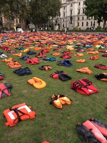 Ballarat Heritage Services
Digital photograph, Life jackets on lawn square outside Westminster Abbey, 2016, Monday 19 September 2016
Thousands of life jackets have been laid out on the grass in Parliament Square in London, as world leaders meet at the United Nations in New York to discuss the refugee crisis. The 2,500 jackets used in the one-day "life jacket graveyard" installation were all worn by those who tried to make the crossing from Turkey to the Greek island of Chios. More than 600 of the life jackets on display were used by children, but most of them are pretty useless. A lot of the life jackets provided by people smugglers are virtually fake, and actually soak up water instead — several of those displayed were sliced open. life jackets, refugees, installation -
 Mt Dandenong & District Historical Society Inc.
Photograph, Crescent Bridge Sassafras
The Crescent Bridge crossing Sassafras Creek on 'The Crescent' at Sassafras. View of water and ferns. c1912Black and white copy of a post card a bridge with a bush and tree fern background.On front: Crescent Bridge Sassafrassassafras, crescent bridge, the crescent, tree ferns, bridge -
 Ballarat Tramway Museum
Document - Letter/s, Lloyd Jenkins, Apr. 1999
Copy of letter to the Secretary (Original with Secretary and copy to Alan Bradley) from Lloyd Jenkins accompanying the donation of history of the Borough of Sebastopol (see Reg. Item 1090), along with notes discussing the reason for the tram track to Sebastopol crossing from one side of Albert St. to the other near Trinity Church and other stories of the tramway. The water supply dam for the Star of the East dam was in the way. Also comments regarding Fares Please! Has date received stamp in top right hand corner. Part of letter in May 1999 Fares Please! See May 1999 Fares Please!In top right hand corner, btm date received stamp and correspondence number.trams, tramways, sebastopol, albert st, star of the east, stories -
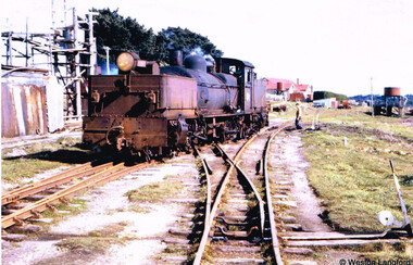 Otway Districts Historical Society
Photograph, Langford, Weston, Beech Forest: G42 traversing the scissors crossover, 1961, 9 August 1961
Colour. Locomotive G42 traversing the scissors or delta crossover during shunting operations at Beech Forest on 9 August 1961. A man operates the points. To the right the Beech Forest Hall and Otway Shire offices, and the Water Tank for the use of locomotives. On the left, the remains of a timber extraction system.beech forest; railways; delta crossing; scissors crossing; -
 Bendigo Historical Society Inc.
Slide - DIGGERS & MINING. GETTING THE GOLD, c1850s
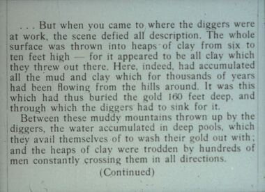
Diggers & Mining. Getting the Gold. Slide: But when you came to where the diggers were at work, the scene defied all description. The whole surface was thrown into heaps of clay from six to ten feet high - for it appeared to be all clay which they threw out there. Here, indeed, had accumulated all the mud and clay which for thousands of years had been flowing from the hills around, It was this which had thus buried the gold 160 feet deep, and through which the diggers had to sink for it. Between these muddy mountains thrown up by diggers, the water accumulated in deep pools which they avail themselves of to was their gold our with and the heaps of clay were trodden by hundreds of men constantly crossing them in all directions. (Continued) Markings: 33 994.LIF:4. Used as a teaching aid.hanimounteducation, tertiary, goldfields -
 Bendigo Historical Society Inc.
Slide - DIGGERS & MINING: THE DIGGERS, c1900s
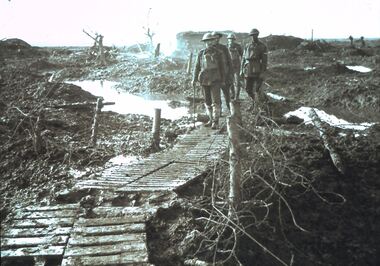
Diggers & Mining: The Diggers. Four Diggers crossing the boardwalk over the muddy was field. Boardwalk has posts either side with barbed wire on them. Water is lying either side of the boardwalk. No fighting at time of photo. Markings: VISAR COPYRIGHT SET - THE DIGGERS, 14. Used as a teaching aid.Visaireducation, tertiary, war -
 Bendigo Historical Society Inc.
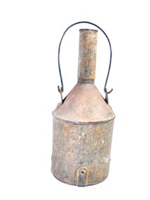
Container - Miner's Water Container
Containers like these were used to hold water for miners working underground. In mines the word "crib" refers to a meal break time. A crib tin would have accompanied the crib bottle. The word "crib" is probably of Cornish origin.A metal container 38 centimetres high and 16 centimetres wide made in three sections with a half centimetre thick metal handle that extends ten centimetres above the container. the bottom section is an oval shape 16 centimetres by 12 centimetres and is 18 centimetres high it is reinforced with two two centimetre wide straps crossing the bottom and extends six centimetres up the sides and is secured with rivets. The next section is a conical shape that extends for eight centimetres and finishes forming a four centimetre circle. A four centimetre tube extends for 12 centimetres.The handle is a 27 centimetres high loop of half centimetre round metal and is attached to the conical section of the container. metal container, crib bottle, miner's water container -
 Kew Historical Society Inc
Photograph - Crossing Dights' Falls on the Yarra by foot
Dight’s Falls in Studley Park is an artificial weir built on a natural rock bar across the Yarra. The weir was built in the 1840s to provide water to the ‘Ceres’ flour-mill, one of the first in Victoria. The falls were later to become known as Dight’s Falls after the owners of the mill. Later, a pumping station was built on the Kew side of the river, which pumped water uphill to a reservoir in Walmer Street that provided water to the Melbourne Botanical Gardens and to Albert Park Lake. The area around Dight’s Falls was and is frequently used for recreational activities.Rare original print photograph of people walking across Dight's Falls when the river flow was low. View west towards Abbotsford. Photograph taken from Kew side of river above the Falls.Reverse: "M Holmes"dight's falls, river yarra -- kew - abbotsford -
![Jebb's Pool, on the Erskine River, Near Lorne / [by] Nicholas Caire, circa 1876](/media/collectors/550653872162f11fb04854aa/items/57831524d0cdd1176c4c6452/item-media/5783159dd0cdd1176c4d1cd3/item-fit-380x285.jpg) Kew Historical Society Inc
Kew Historical Society IncPhotograph, Anglo-Australasian Photographic Company, Jebb's Pool, on the Erskine River, Near Lorne, c. 1876
Nicholas Caire was born on Guernsey in the Channel Islands in 1837. He arrived in Adelaide with his parents in about 1860. In 1867, following photographic journeys in Gippsland, he opened a studio in Adelaide. From 1870 to 1876 he lived and worked in Talbot in Central Victoria. In 1876 he purchased T. F. Chuck's studios in the Royal Arcade Melbourne. In 1885, following the introduction of dry plate photography, he began a series of landscape series, which were commercially successful. As a photographer, he travelled extensively through Victoria, photographing places few of his contemporaries had previously seen. He died in 1918. Reference: Jack Cato, 'Caire, Nicholas John (1837–1918)', Australian Dictionary of Biography.An original, rare photograph from the series 'Views of Victoria: General Series' by the photographer, Nicholas Caire (1837-1918). The 60 photographs that comprise the series were issued c. 1876 and reinforced a neo-Romantic view of the Australian landscape to which a growing nationalist movement would respond. Nicholas Caire was active as a photographer in Australia from 1858 until his death in 1918. His vision of the Australian bush and pioneer life had a counterpart in the works of Henry Lawson and other nationalist poets, authors and painters.'Jebb’s Pool, on the Erskine River, near Lorne’ : Views of Victoria (General Series) No.51 : Albumen silver photograph | Photo on card with Title and Description on reverse | Mounted 24 x 30 cm; Photo 12 x 17 cm.On Reverse: ‘Jebb’s Pool is situated about four miles from the township of Lorne, and is so called in consequence of a gentleman named Jebb, whilst crossing the cataract, having fallen in and was swept down by the current into a whirlpool which is continually in motion, owing to the particular formation of the river and the powerful current of water. The depth of water in the pool must be considerable, as but for the timely assistance rendered his life would have been sacrificed.’nicholas caire (1837-1918), lorne (vic), erskine river (vic), landscape photography - victoria -
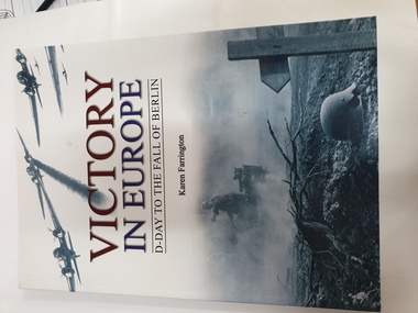 Clayton RSL Sub Branch
soft cover non-fiction book, Ice Water Press, Victory In Europe, 2010
The final crossing of the Rhine and the advance into Germany changed the course of European history forever. Introduces men and women from bith sides - British, American and German soldiers and civilians - whose bravery and endurance made the final push through Europe the defining drama of WW2.Soft cover book with 144 pagessticker on inside page P Cooper (personal contact details included on sticker) -
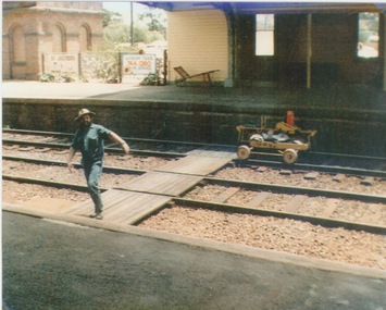 Sunbury Family History and Heritage Society Inc.
Photograph, c 1970
A railway maintenance person is crossing the railway tracks from Platform 2 to Platform 1 at Sunbury Station. There is a partial view of the historic brick water tower, which was used by the steam engines, on Platform 2.A coloured photograph of a maintenance man walking across a railway track at a station.sunbury railway station, water towers -
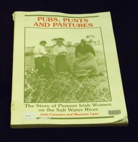 Melbourne's Living Museum of the West
Book, St Albans History Society Inc, Pubs, Punts and Pastures, 1988
Tells the story of early Irish Pioneering Women who settled the Maribyrnong River Valley (formerly Salt Water River) and founded the first hotels, punts (river crossing barges) and farms in the region; and focuses on six particular women and their stories.Book now out of print. Funds from the sales of this book were used to build the monument "The Pioneer Womens Shelter" in Pipemakers Park.Book, soft card cover, 178 pagesISBN 0958808406 Book dedication "This book is dedicated to all women who made the voyage under sail"book, womens history, irish women, pioneers, maribyrnong river, salt water river -
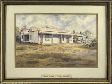 Port Fairy Historical Society Museum and Archives
Painting - painting, watercolour, Horse and Jockey Hotel Orford, 01.02.1984
Painted for Mrs Ruby Young whose family owned the hotel at one time - (since burnt down) The hotel was built around 1857 near "Shaw Crossing" when Cowton and Bland selected the site because the bullockies watered and rested their stock on route Belfast and Portland. The name of the hotel came about because the winning post for the horse races was in front of the inn and the jockeys weighed in there.Illustration of a hotel that became the hub of social life in Orford that no longer exists.Watercolour painting of "Horse and Jockey" Hotel Orford. Frame composite wooden gilt embossingChristopher Mathews Ruby Young 1989 50 Whalers Road Victor Harbor S.A. 5211 1/2/84local history, illustrations, watercolours, horse and jockey hotel, ruby young, horseracing -
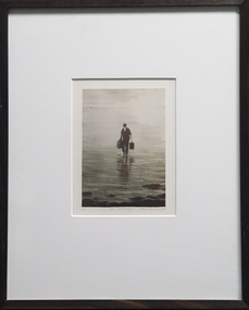 Federation University Art Collection
Print, Louise Tomlinson, The Crossing, 1999
... depicting a man carrying bags through water. The Crossing Print ...Louise TOMLINSON (1964- ) Born Tongala, Victoria In 1980 Louise Tomlinson decided to relocate to Ballarat to study fine artFramed lithograph depicting a man carrying bags through water.LL1/25 Centre "The Crossing" LR Thomlinson '98available, alumni